Monday, September 13, 2021

NYK tests AI system to automatically identify navigation hazards

Cameras and AI identify navigation hazards that might be missed by the human eye (NYK)
 
From Maritime Executive  

Efforts are continuing to explore the use of automation, artificial intelligence, and image recognition to improve the navigation and safety of ship operations.
Earlier this year, Japan’s Mitsui O.S.K. Lines demonstrated its efforts are using augmented reality (AR) technology to enhance navigational awareness and now NYK announced that it has begun a trial on the system that can monitor the horizon to recognize dangerous objects that might be within a ship’s range.

NYK working with its strategic research and development subsidiary MTI Co. installed the Automatic Ship Target recognition System developed in Israel by Orca AI on one of NYK’s vessels.
The goal is to verify the detection capability and the contribution the system can make to the role of the lookout on a ship’s bridge.
Working with Orca, NYK also plans to improve the target detection algorithm through the use of data collection and machine learning on the Israeli company’s servers.
During the trial, they are also looking to enhance the recognition rate so that the system could be used to enhance efforts to develop autonomous shipping.
 
Orca’s AI navigation and collision avoidance system is engineered to help create a new lookout support system for vessels by providing improved visibility in difficult conditions, preventing human error, and helping crews make informed decisions.
 
While research has been ongoing on automatic identification by image analysis, according to NYK earlier systems were limited by the ability of cameras to receiving images both at day and night especially with ships exposed the natural elements including rain and wind.
Also, they said that no system could measure the distance from the captured image to the target with a certain degree of accuracy.

The new system NYK explained uses a camera unit that can shoot day and night to automatically recognize ships and targets and measure the distance to them.
Information obtained from navigational equipment, including vessel names, distance, and time when the ship is closest to the target, can be superimposed and displayed in an integrated manner to a tablet or touch-panel monitor display.
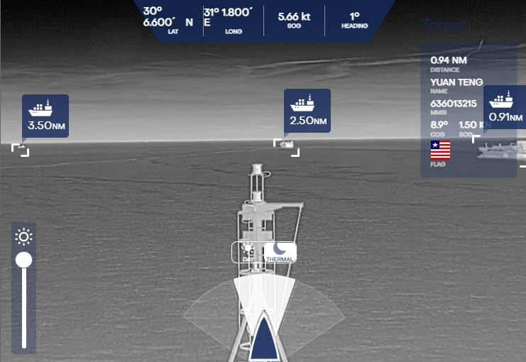

Using infrared cameras the system creates nighttime images (NYK)

Orca AI notes that nearly 4,000 maritime accidents occur annually and are caused they believe by low situational awareness in congested areas, lack of office visibility regarding misses and risk patterns, and insufficient data available for handling potential incidents.

The system is designed to automatically recognizing dangerous objects and other vessels that may be overlooked by the human eye, especially at night and in congested waters.
NYK is seeking to verify this capability noting that the system could be revolutionary in its capabilities to independently recognize small fishing boats and small markers that are not captured by radar and not equipped with AIS.
The system measures the distance to these targets and notifies the person on duty of collision danger.
 

The videos you are about to see were taken from real ships that sailed during the winter with Orca AI
 
The test vessel is equipped with three cameras and three infrared cameras to make nighttime imaging possible.
The system has an angle of view of 120 degrees.
With the video images and data also being relayed to Orca AI’s servers, NYK notes it is possible to monitor the movement of the ship from shore.

In addition, in joint research conducted by NYK and MTI with Orca AI, the system was also installed on domestic vessels to collect information on the Japanese coast, as well as fishing boats, fishing gear, and buoys peculiar to Japan.
This will be used in support of NYK’s efforts with autonomous shipping.

Links :

Sunday, September 12, 2021

New Zealand (Linz) update in the GeoGarage platform

9 nautical raster charts updated

Rolex Fastnet Race 2021 : an impressive spectacle

The 49th edition of Rolex Fastnet Race started from Cowes, England, on 8 August, with over 300 yachts setting off into the teeth of a strong westerly.
First held in 1925, the demanding offshore classic has a legendary status in sport. Organized by the Royal Ocean Racing Club, the race has been partnered by Rolex since 2001 and demands the very best in skill, determination and teamwork to succeed.
Divided into seven starting groups, the fleet crossed the Royal Yacht Squadron line and headed west down The Solent, before entering the English Channel.
Competitors are a mix of professional and Corinthians, experienced and newcomers, young and old. With the race finishing in Cherbourg, France for the very first time, the crews face a new twist to the near 100-year-old challenge.

Saturday, September 11, 2021

Image of the week :largest island in the North Sea bay of Kattegat, Denmark

Amazing layers of turbid waters surrounding and moving around the island which is the largest in the North Sea bay of Kattegat, northern Denmark Læsø ("Isle of Hlér") 
@CopernicusEU Sentinel2  2021-08-30
 
courtesy of Iban Amestoy
 
Læsø island with the GeoGarage platform

Friday, September 10, 2021

Arctic’s ‘last ice area’ may be less resistant to global warming

 
The German research icebreaker Polarstern heading toward the North Pole through thin ice last August.

From NYTimes by Henri Fountain

The region, which could provide a last refuge for polar bears and other Arctic wildlife that depends on ice, is not as stable as previously thought, according to a new study.

Last August, scientists aboard an icebreaker that had been drifting with the ice across the Arctic Ocean in a yearlong research expedition decided to take a detour to the North Pole.

They needed to get there quickly, so they used satellite data to find a route where the concentration of sea ice was low enough for the icebreaker, the Polarstern, to push through easily.
They found it in an unlikely place, the Wandel Sea, just north of Greenland.

“This area used to be one that was chock-full of this old, thick sea ice,” said Melinda Webster, a researcher at the University of Alaska Fairbanks who was on board for this part of the Mosaic expedition. 
“It’s not what we encountered when we went through there.”
 
Instead, the ice was thin and there was plenty of open water, Dr. Webster said.

Scientists have now shown why ice conditions in the Wandel Sea were vastly different last summer.
The warming Arctic climate thinned the ice, they say, and an unusual shift in winds pushed much of it out of the sea.
 

“As it is typically with extreme events, there’s an underlying climate change component,” said Axel J. Schweiger, a climate scientist at the University of Washington and the lead author of a paper describing the research published Thursday in the journal Communications Earth & Environment.

The findings have potentially troubling implications for the Wandel Sea and nearby waters north of Canada, a region often referred to as the “last ice area.”
Because a circular ocean current, the Beaufort Gyre, tends to keep ice trapped there, climate models have predicted that it will likely retain ice as warming causes the rest of the Arctic Ocean to become ice-free in summers, perhaps in the next few decades.

If this region does remain full of ice, it may provide a last summer refuge for polar bears and other Arctic wildlife that is dependent on sea ice.
But the new research suggests the area may be less resilient to warming, and that similar periods of low ice concentrations are to be expected.

“This region is not as stable as we used to think,” said Luisa von Albedyll, an ice-dynamics researcher with the Alfred Wegener Institute in Germany, who also was aboard the Polarstern when the route was chosen. Neither she nor Dr. Webster was involved in the new research.

Dr. Schweiger and other researchers had seen and studied thinning ice in the Wandel Sea in recent years, including a time in 2018 when a large area of open water, called a polynya, had opened.
The experience of the Polarstern also piqued Dr. Schweiger’s interest.
The route “normally wouldn’t be the first choice for an icebreaker captain,” he said.
 

Using satellite images and computer models that simulated sea ice, he and his colleagues showed that most of the effect on the ice in the Wandel in 2020 could be linked to natural variability in the winds in the area.

Those winds normally blow from the north and, with the Greenland and Canadian coasts to the south, tend to keep the ice in place.
 
In August 2020 they shifted so they were blowing in the opposite direction, causing much of the ice to leave the sea and drift elsewhere.
 

But the simulations also showed that climate change played a role by melting and thinning the ice, as it has elsewhere in the Arctic Ocean in recent decades.
While the world overall is warming as a result of human-caused emissions of carbon dioxide and other heat-trapping gases, the Arctic is warming about two and a half times faster than average, much faster than other regions.

The researchers also looked at what might have occurred in previous years under the same wind conditions that existed last summer, using data beginning in 1979, when modern satellite imagery of the Arctic began.

The analysis showed that if the same shifting winds had occurred in 2018 and 2019, similar low-ice conditions would have resulted.
“But the likelihood that this would have happened with ice from 1979 is a lot smaller,” Dr. Schweiger said, because the region had not warmed as much at that point and the ice was thicker.

Dr. Webster said the study provided a “very reasonable explanation” for what occurred last summer. And it illustrated an important point about the effects of climate change in the Arctic, she said.

“As sea ice thins and as it becomes more seasonal, it becomes more sensitive to what’s happening in the atmosphere and ocean,” she said. 
“So windy conditions will play a larger role.”

“What we experienced last summer was unprecedented,” Dr. Webster added.