Wednesday, May 20, 2020

Ancient vs modern nautical maps

Ancient nautical map of Ouessant island (France) from Beautemps-Beaupré hydrographer (1822)

 modern nautical chart (SHOM) overlaid upon Google Maps in the GeoGarage platform

Research expedition to map Scottish seabed

The HyBIS Robotic Underwater Vehicle collected more than 75 hours of high-definition video data.

From Hydro

Slow recovery of coral reef shows impact of bottom trawling

Newly developed 3D imaging technology has allowed scientists to map Darwin Mounds, a unique area of cold-water coral reefs off the coast of Scotland, to see whether it has recovered since being declared a Marine Protected Area sixteen years ago.

 Darwin mounts in the GeoGarage platform (UKHO nautical chart)


The images show that in areas of the Darwin Mounds that had been heavily trawled, coral growth is still very sparse, and there has been no real recolonization.
However, healthy coral growth was found in parts that had only been minimally damaged by bottom trawling, indicating that marine conservation measures are most effective when they are put in place before damage occurs.
The team also discovered a large amount of plastic waste snagged on the coral.

Dr Veerle Huvenne from the National Oceanography Centre (NOC), and chief scientist of the expedition that made these discoveries, said, “This proves once again that ecosystem recovery in the deep sea is very slow, and that it is better to put protective measures in place before damage occurs.
However, encouragingly, settlement experiments deployed in 2011 and recovered on this expedition indicate that new coral larvae can indeed settle in the area.”

 Ship Discovery

High-Definition Video Data

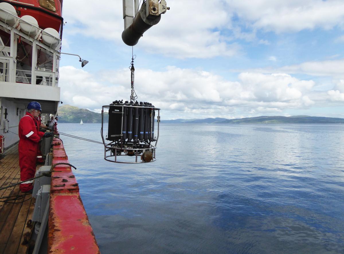
These findings are the result of a three-week research expedition in the North-East Atlantic on board the Royal Research Ship Discovery, home port Southampton, UK.
This expedition was a collaboration between the NOC, the University of Southampton, the Joint Nature Conservation Committee, the University of Edinburgh, University College Cork and the Scottish Association for Marine Science.
Using the latest in marine and robotic technology, the team collected data to evaluate the status of the Darwin Mounds, a series of cold-water coral reefs lying at water depths of 1,000 metres, once heavily impacted by bottom trawling.

BioCam, a combined stereo camera and laser scanner built by the University of Southampton under NERC’s Oceanids Programme, was used to create multi-hectare 3D visual reconstructions of the seabed.

This expedition saw the first deployment of a newly developed 3D imaging system called BioCam, a combined stereo camera and laser scanner built by the University of Southampton under NERC’s Oceanids Programme, which was used to create multi-hectare 3D visual reconstructions of the seabed.
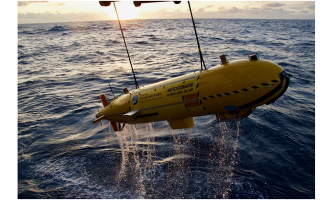
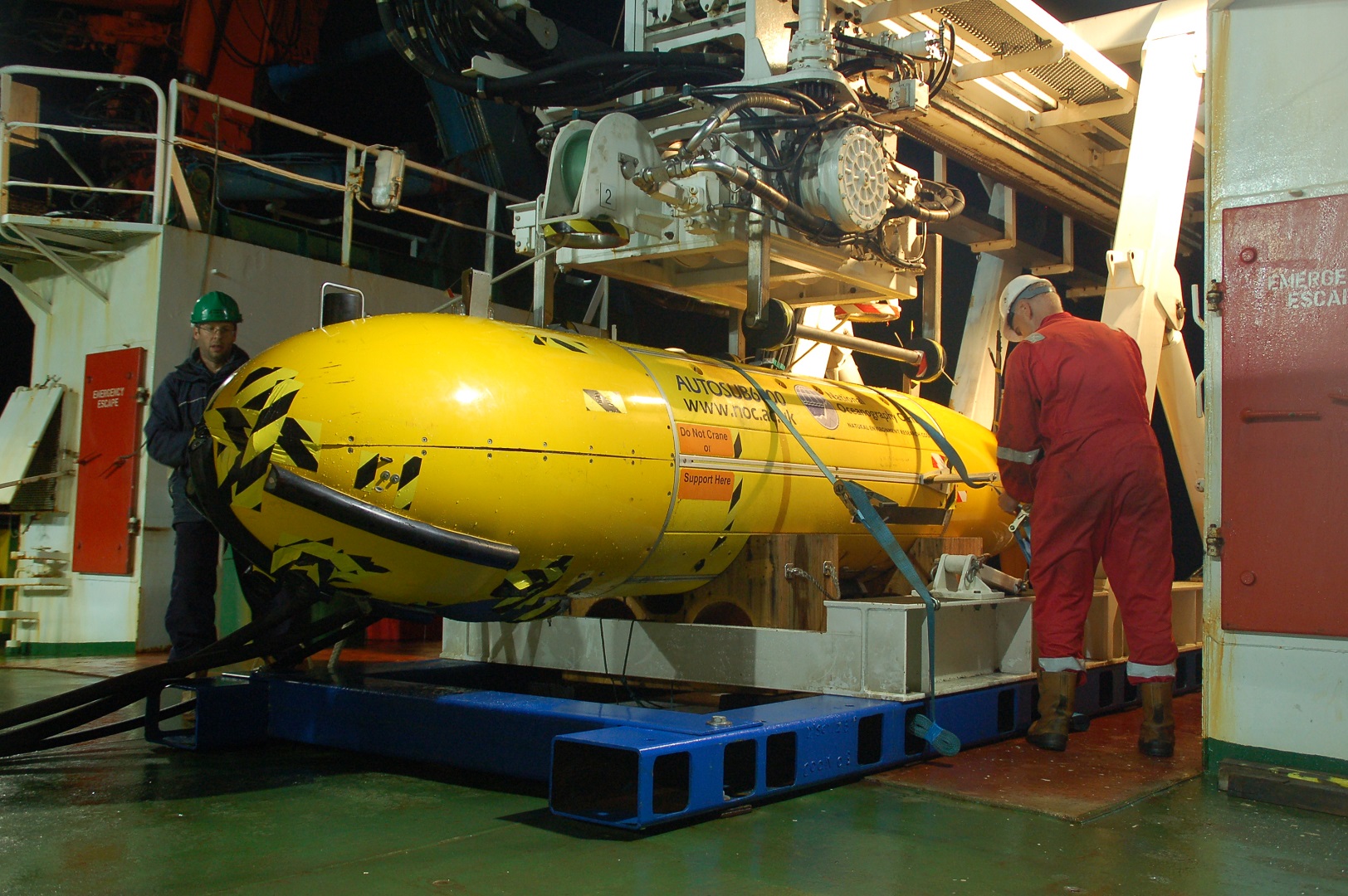
Mounted on Autosub6000, a robot sub developed and operated by the NOC, the system successfully mapped more than 50 hectares of seabed in less than 48 hours at photographic resolution.

Together with an extensive series of samples, and more than 75 hours of high-definition video data collected by the HyBIS Robotic Underwater Vehicle, the BioCam images provided evidence of healthy coral growth in locations that previously had seen only a minimal impact from bottom trawling.

 Autosub 6000

Cold-water Reefs

Cold-water corals are coral species that can live without light, and the reefs they build are important habitats for a wide variety of deep-sea life, including commercially important fish.
The Darwin Mounds have been protected from bottom contact fisheries since 2003, and were last studied in 2011, at which point they had not yet recovered from the fishing impacts.

Dr Veerle Huvenne continued, “It was very encouraging to see the recruitment of new coral polyps on the settlement experiments, although this has not yet translated into widespread new coral growth in the heavily impacted areas.
We will continue to monitor the site over the coming years to learn more about how deep-sea ecosystems recover after disturbance.”

“Working with the new BioCam system gave us an unprecedented insight into the spatial pattern of the coral growth.
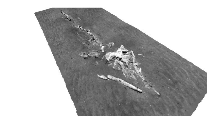
It also showed us how the marine animals are living with and around the coral, and it even provided us with unexpected discoveries, such as a complete whale skeleton that we had no idea was on the seabed in the area.”

Dr Blair Thornton, co-chief scientist and leader of the BioCam team said, “The multi-hectare scale maps generated by BioCam highlight a wide range of patterns in the spatial distribution of coral and the ecology at this site.
These range from the fine, metre-scale patterns seen in video surveys, to much larger patterns in the distribution of live coral over several hundreds of metres.
The data will help scientists to identify these and to measure the distribution of live coral in this area.”


Large amount of made-made litter

“The fact that BioCam was able to collect data that is useful for scientific monitoring on its first deployment is a tribute to the hard work that went into preparations for this expedition from the teams at the University of Southampton, the MARS team at the NOC, local industry partners and the captain and crew of the RRS Discovery.
We are looking forward to its next deployment.” Unfortunately, the imagery also demonstrated the presence of a large amount of man-made litter.
The area is characterized by strong tidal currents, and coral colonies form natural obstacles on which plastic debris can easily snag.

Hayley Hinchen from the Joint Nature Conservation Committee said, “It has been fascinating to see first-hand the coral mounds in the area, some of which are thriving and others which are struggling to recover.
This survey has confirmed that, even after more than 15 years of fisheries closures, the impacts of bottom trawling are still evident, and some newer pressures seem to be growing.
The level of litter that we observed across the site is quite shocking, and we still don’t know how this is affecting the seabed communities we’ve seen over the last three weeks.

“The wealth of data collected on this expedition will allow us to assess the current status of the habitats and species in the Darwin Mounds both at the small and large scale, and to define how it has changed over time.
The amazing 3D imagery from the BioCam system allows us to investigate huge areas of the seabed at millimetre-scale resolution – a tool that could really support marine monitoring and conservation efforts in the future”, Hinchen adds.

In their final blog post, two members of the expedition, Loic Van Audenhaege and Larissa Macedo, wrote, “Reef-forming cold-water corals and many sponges require specific environmental conditions for settlement, such as the presence of a hard substrate, which remains a rare feature of the seabed.
In the Darwin Mounds area, our dives allowed us to observe that sand and mud make up the primary substrate of the seafloor, except on the mounds themselves.”

They continued, “Reef-forming cold-water corals cannot grow on a soft substrate.
This was well-observed in our previous blog post as new cold-water corals were growing on an eight-year-old buoy, but none were observed growing on the surrounding seabed.
While many organisms can sustain themselves in a soft-substrate environment, the apparent biodiversity remains low, compared to what we can see from the pictures of the coral reefs.
However, it would be foolish to state that this type of habitat is not biologically interesting.
Photographs have limitations in terms of showing the full variety of forms in which life can occur.
For instance, as revealed by the box core operations, many tiny organisms thrive in the sediment and they may encompass an equally important part of the life at the Darwin Mounds site.”


Further detailed analysis of the imagery and samples will be necessary to fully evaluate the changes in biodiversity and communities of marine animals in the area since 2011.
This work is part of the CLASS programme (Climate Linked Atlantic Sector Science), which aims to increase our understanding of how the ocean will evolve under a changing climate and increased human exploitation, with the objective of supporting sustainable marine management.
The BioCam project is funded by the NERC’s Oceanids Programme.

About the NOC
The NOC is the UK’s primary centre for providing national capability for oceanographic sciences.
Our vision is to be one of the world’s top three oceanographic research institutions, leading the way in the advancement of knowledge and understanding of our oceans.
The institute provides the UK with the national capability needed to be a top global player and to lead and participate in international cooperation.
The NOC undertakes research in large-scale oceanography and ocean measurement technology innovation.
It works with government and business to turn great science and technology into advice and applications.
The NOC supports the UK science community, based in universities and smaller research institutes, with scientific facilities, research infrastructure and irreplaceable data assets – enabling the UK to harness the full power and diversity of its scientific talent in ocean science.

Links :

US (NOAA) layer update in the GeoGarage platform

5 nautical raster charts updated

Tuesday, May 19, 2020

Underwater telecom cables make superb seismic network

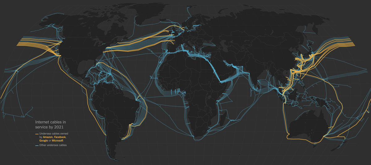
The oceans are criss-crossed by telecommunications cables, as illustrated by this graphic predicting the fiber-optic cables that will be operational by 2021, many of them (yellow) owned by private companies like Google and Microsoft.
These cables could serve a dual purpose as seismic stations to monitor earthquakes and fault systems over the 70% of Earth covered by water.
(Graphic courtesy of New York Times)

From Berkeley by Robert Sanders

Fiber-optic cables that constitute a global undersea telecommunications network could one day help scientists study offshore earthquakes and the geologic structures hidden deep beneath the ocean surface.

In a paper appearing this week in the journal Science, researchers from the University of California, Berkeley, Lawrence Berkeley National Laboratory (Berkeley Lab), Monterey Bay Aquarium Research Institute (MBARI) and Rice University describe an experiment that turned 20 kilometers of undersea fiber-optic cable into the equivalent of 10,000 seismic stations along the ocean floor.
During their four-day experiment in Monterey Bay, they recorded a 3.5 magnitude quake and seismic scattering from underwater fault zones.

Their technique, which they had previously tested with fiber-optic cables on land, could provide much-needed data on quakes that occur under the sea, where few seismic stations exist, leaving 70% of Earth’s surface without earthquake detectors.

“There is a huge need for seafloor seismology.
Any instrumentation you get out into the ocean, even if it is only for the first 50 kilometers from shore, will be very useful,” said Nate Lindsey, a UC Berkeley graduate student and lead author of the paper.

Lindsey and Jonathan Ajo-Franklin, a geophysics professor at Rice University in Houston and a faculty scientist at Berkeley Lab, led the experiment with the assistance of Craig Dawe of MBARI, which owns the fiber-optic cable.
The cable stretches 52 kilometers offshore to the first seismic station ever placed on the floor of the Pacific Ocean, put there 17 years ago by MBARI and Barbara Romanowicz, a UC Berkeley Professor of the Graduate School in the Department of Earth and Planetary Science.
A permanent cable to the Monterey Accelerated Research System (MARS) node was laid in 2009, 20 kilometers of which were used in this test while off-line for yearly maintenance in March 2018.

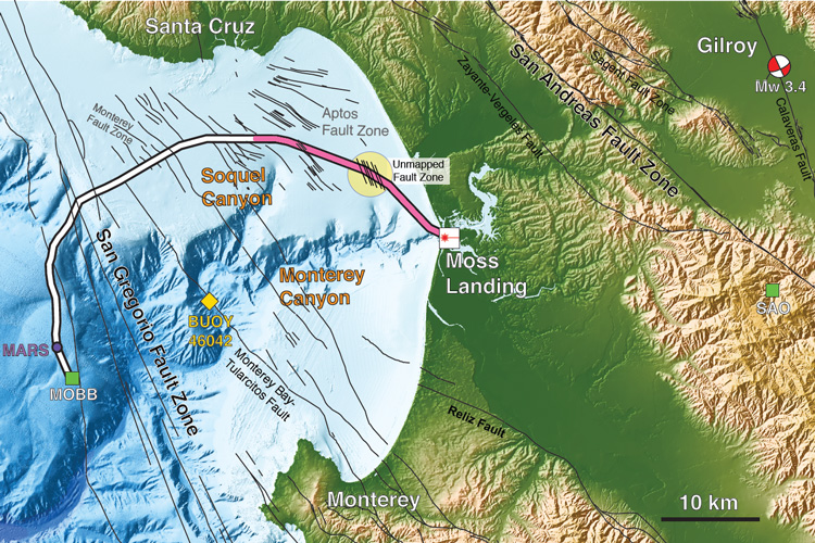
Researchers employed 20 kilometers (pink) of a 51-kilometer undersea fiber-optic cable, normally used to communicate with an off-shore science node (MARS, Monterey Accelerated Research System), as a seismic array to study the fault zones under Monterey Bay.
During the four-day test, the scientists detected a magnitude 3.5 earthquake 45 kilometers away in Gilroy, and mapped previously uncharted fault zones (yellow circle).
(Image by Nate Lindsey)

“This is really a study on the frontier of seismology, the first time anyone has used offshore fiber-optic cables for looking at these types of oceanographic signals or for imaging fault structures,” said Ajo-Franklin.
“One of the blank spots in the seismographic network worldwide is in the oceans.”

The ultimate goal of the researchers’ efforts, he said, is to use the dense fiber-optic networks around the world — probably more than 10 million kilometers in all, on both land and under the sea — as sensitive measures of Earth’s movement, allowing earthquake monitoring in regions that don’t have expensive ground stations like those that dot much of earthquake-prone California and the Pacific Coast.

“The existing seismic network tends to have high-precision instruments, but is relatively sparse, whereas this gives you access to a much denser array,” said Ajo-Franklin.
Photonic seismology

The technique the researchers use is Distributed Acoustic Sensing, which employs a photonic device that sends short pulses of laser light down the cable and detects the backscattering created by strain in the cable that is caused by stretching.
With interferometry, they can measure the backscatter every 2 meters (6 feet), effectively turning a 20-kilometer cable into 10,000 individual motion sensors.

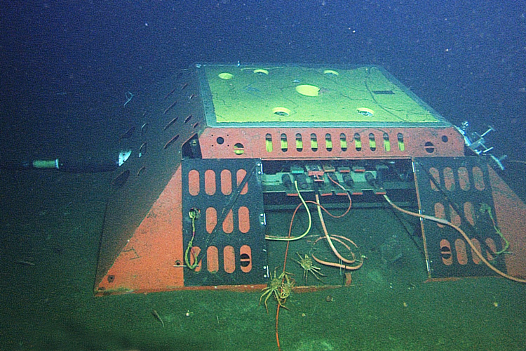
The Monterey Accelerated Research System (MARS) cabled observatory, a node for science instruments on the ocean floor 891 meters (2,923 feet) below the surface of Monterey Bay, is connected to shore by a 52-kilometer (32-mile) undersea cable that carries data and power.
About 20 kilometers of the cable was used to test photonic seismology on the seafloor.
(Copyright MBARI, 2009)

“These systems are sensitive to changes of nanometers to hundreds of picometers for every meter of length,” Ajo-Franklin said.
“That is a one-part-in-a-billion change.”

Earlier this year, they reported the results of a six-month trial on land using 22 kilometers of cable near Sacramento emplaced by the Department of Energy as part of its 13,000-mile ESnet Dark Fiber Testbed.
Dark fiber refers to optical cables laid underground, but unused or leased out for short-term use, in contrast to the actively used “lit” internet.
The researchers were able to monitor seismic activity and environmental noise and obtain subsurface images at a higher resolution and larger scale than would have been possible with a traditional sensor network.

“The beauty of fiber-optic seismology is that you can use existing telecommunications cables without having to put out 10,000 seismometers,” Lindsey said.
“You just walk out to the site and connect the instrument to the end of the fiber.”

During the underwater test, they were able to measure a broad range of frequencies of seismic waves from a magnitude 3.4 earthquake that occurred 45 kilometers inland near Gilroy, California, and map multiple known and previously unmapped submarine fault zones, part of the San Gregorio Fault system.
They also were able to detect steady-state ocean waves — so-called ocean microseisms — as well as storm waves, all of which matched buoy and land seismic measurements.

“We have huge knowledge gaps about processes on the ocean floor and the structure of the oceanic crust because it is challenging to put instruments like seismometers at the bottom of the sea,” said Michael Manga, a UC Berkeley professor of earth and planetary science.
“This research shows the promise of using existing fiber-optic cables as arrays of sensors to image in new ways.
Here, they’ve identified previously hypothesized waves that had not been detected before.”

According to Lindsey, there’s rising interest among seismologists to record Earth’s ambient noise field caused by interactions between the ocean and the continental land: essentially, waves sloshing around near coastlines.

“By using these coastal fiber optic cables, we can basically watch the waves we are used to seeing from shore mapped onto the seafloor, and the way these ocean waves couple into the Earth to create seismic waves,” he said.

To make use of the world’s lit fiber-optic cables, Lindsey and Ajo-Franklin need to show that they can ping laser pulses through one channel without interfering with other channels in the fiber that carry independent data packets.
They’re conducting experiments now with lit fibers, while also planning fiber-optic monitoring of seismic events in a geothermal area south of Southern California’s Salton Sea, in the Brawley seismic zone.

Links :


Monday, May 18, 2020

35 years of submarine cables in one map

The 400 or so submarine cables weave an invisible yet crucial network of the contemporary world. 1.3 million km long, they are essential to the smooth functioning of the Internet and host 99% of our intercontinental exchanges.

From VisualCapitalist by Nick Routley

You could be reading this article from nearly anywhere in the world and there’s a good chance it loaded in mere seconds.

Long gone are the days when images would load pixel row by pixel row. Now, even high-quality video is instantly accessible from almost everywhere. How did the internet get so fast? Because it’s moving at the speed of light.


The Information Superhighway

The miracle of modern fiber optics can be traced to a single man, Narinder Singh Kapany.
The young physicist was skeptical when his professors asserted that light ‘always travels in a straight line’.
His explorations into the behavior of light eventually led to the creation of fiber optics—essentially, beaming light through a thin glass tube.

The next step to using fiber optics as a means of communication was lowering the cable’s attenuation rate.
Throughout the 1960-70s, companies made gains in manufacturing, reducing the number of impurities and allowing light to cross great distances without a dramatic decrease in signal intensity.

By the mid-1980s, long distance fiber optic cables had finally reached the feasibility stage.
Crossing the Pond

The first intercontinental fiber optic cable was strung across the floor of the Atlantic Ocean in 1988.
The cable—known as TAT-8*—was spearheaded by three companies; AT&T, France Télécom, and British Telecom.
The cable was able to carry the equivalent of 40,000 telephone channels, a ten-fold increase over its galvanic predecessor, TAT-7.

Once the kinks of the new cable were worked out, the floodgates were open.
During the course of the 1990s, many more cables hit the ocean floor.

Deep on the ocean floor you will find communication cables made to carry signals from one land to another.
The first undersea communications cables, laid in the 1850s, carried telegraphy.
Now these cables carry our phone and Internet traffic.
Yet, they remain relatively hidden in the depths of the ocean.

By the dawn of the new millennium, every populated continent on Earth was connected by fiber optic cables.
The physical network of the internet was beginning to take shape.

As today’s video from ESRI shows, the early 2000s saw a boom in undersea cable development, reflecting the uptick in internet usage around globe.
In 2001 alone, eight new cables connected North America and Europe.

From 2016-2020, over 100 new cables were laid with an estimated value of $14 billion.
Now, even the most remote Polynesian islands have access to high-speed internet thanks to undersea cables.

*TAT-8 does not appear in the video above as it was retired in 2002.
The Shifting Nature of Cable Construction

Even though nearly every corner of the globe is now physically connected, the rate of cable construction is not slowing down.

This is due to the increasing capacity of new cables and our appetite for high-quality video content.

New cables are so efficient that the majority of potential capacity along major cable routes will come from cables that are less than five years old.

Traditionally, a consortium of telecom companies or governments would fund cable construction, but tech companies are increasingly funding their own submarine cable networks.


Amazon, Microsoft and Google own close to 65% market share in cloud data storage, so it’s understandable that they’d want to control the physical means of transporting that data as well.

These three companies now own 63,605 miles of submarine cable.
While laying cable is a costly endeavor, it’s necessary to meet surging demand—content providers’ share of data transmission skyrocketed from around 8% to nearly 40% over the past decade.
A Bright Future for Dark Fiber

At the same time, more aging cables will be taken offline.
Even though signals are no longer traveling through this network of “dark fiber”, it’s still being put to productive use.
It turns out that undersea telecom cables make a very effective seismic network, helping researchers study offshore earthquakes and the geologic structures on the ocean floor.

Links :