Go on an audio cruise of 27 islands never proven to have existed.
Berlin-based sound artist Andrew Pekler has created an interactive online map called Phantom Islands, which combines the histories of islands that were once found on nautical maps with speculative sounds from each of the 27 locations.
“Phantom Islands are artifacts of the age of maritime discovery and colonial expansion,” Pekler writes.
“During centuries of ocean exploration these islands were sighted, charted, described and even explored – but their existence has never been ultimately verified.
“Poised somewhere between cartographical fact and maritime fiction, they haunted seafarers’ maps for hundreds of years, inspiring legends, fantasies, and counterfactual histories.
“Phantom Islands – A Sonic Atlas interprets and presents these imaginations in the form of an interactive map which charts the sounds of a number of historical phantom islands.”
You can zoom in on individual islands to hear what Pekler describes as their “musical, biophonic and geophonic soundscapes” and click on their names to learn more about their story, or click ‘cruise mode’ to go on an audio tour.
Think of it as like an interactive ambient mixtape with an added history lesson.
Phantom Islands – which was was commissioned by the Jeu de Paume gallery in Paris for its Fourth Worlds: Imaginary Ethnography in Music and Sound exhibition – follows Pekler’s 2016 album Tristes Tropiques, an album of “synthetic exotica, pseudo-ethnographic music and unreal field recordings”.
Whilst the primary purpose of hydrography remains the production of navigational charts, the role of hydrographers is changing fast.
Watch the video to find out about the innovative technology Fugro is developing that will ensure the global hydrographic community is positioned to play a more efficient, effective and important role in managing the marine environment and resources for a liveable world.
A Chinese aircraft carrier leaves Dalian, in China’s northeastern Liaoning Province, in May.
(Li Gang/Xinhua via AP)
From Washington Post by John Lee John Lee is a nonresident fellow at the Hudson Institute in Washington and the United States Studies Center at the University of Sydney. He served as senior national security adviser to the Australian foreign minister from 2016 to 2018.
Indian Prime Minister Narendra Modi delivered the dinner address at the Shangri-La Dialogue, an annual meeting of defense ministers held in Singapore.
As with keynotes by Australia’s Malcolm Turnbull and Japan’s Shinzo Abe in preceding years, Modi championed democratic principles and a free and open Indo-Pacific, while emphasizing respect for territorial rights and international law rights.
The next morning, during the opening plenary session, Defense Secretary Jim Mattis pursued the same theme but in far more pointed terms, calling out China for its intimidation and coercion of smaller nations in the region, which is what much of the room wanted to hear.
Although a number of senior Chinese military officials, including Lt. Gen. He Lei from the Academy of Military Science, were in the room, Mattis’s Chinese counterpart was not there to receive the message.
Beijing has not sent a defense minister to this elite gathering of 40 nations since 2011.
One might empathize with Beijing’s determination to downgrade what it sees as an annual China-bashing event.
But the fact that China has lost the room speaks to the myth that authoritarian countries have the strategic advantage because they can take the long view.
courtesy of the Economist / Michael Morgenstem
Consider Chinese President Xi Jinping’s grand objective of achieving regional dominance through a combination of economic munificence and attempts to ease the United States out of the Indo-Pacific.
The latter can be achieved by degrading and weakening the United States’ alliances with regional powers, a strategy drawn directly from legendary strategist Sun Tzu.
In the last decade of the previous century, a more cautious China concluded relatively generous treaties with Russia, Kazakhstan, Kyrgyzstan and Tajikistan to resolve border disputes and improve ties.
With relations smoothed over, China’s economic weight eventually allowed it to replace Russia as the most significant player in Central Asia.
Xi is ignoring salient historical lessons.
By reigniting age-old territorial disputes or else cooking up history to justify new claims, such as in the East and South China Seas and in border disputes with India, the Chinese leader has managed to alienate almost every significant naval power in the Indo-Pacific.
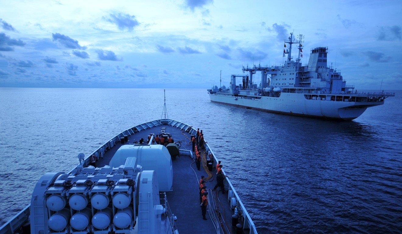
Chinese navy ships sail through the Strait of Malacca. Photo: Xinhua
The harsh words aimed against Beijing over the weekend are just one diplomatic consequence resulting from a counterproductive approach.
U.S. alliances and military cooperation with Japan and Australia are strengthening, as they are with India, which has been driven to discard its non-alignment philosophy in all but name.
We have never seen a powerful United States, Japan, India and China at the same time.
Although Chinese strategists have long feared the formation of a hostile maritime coalition of great powers, Beijing’s hubris is pushing these countries in that direction.
A web of security relationships is also starting to form between India and Vietnam, Indonesia and others.
These are not decisive, but they complicate the environment for China.
Taiwan is also less willing to countenance unification with the mainland than ever before — denying Beijing a strategic asset that Gen. Douglas MacArthur once called an “unsinkable aircraft carrier.” Control of Taiwan would enable the People’s Liberation Army Navy to break out into the Western Pacific.
Indeed, almost all significant maritime countries have moved from a neutral or hedging posture to a countering or balancing one to the extent that they are able.
This includes preparedness to host and support more U.S. military assets and closer naval and intelligence coordination with other countries in response to Chinese activity.
courtesy of the Economist
All this is occurring at a time when China has emerged as the largest merchandise trading country in the world, dependent on the oceans for an overwhelming majority of this trade, and the largest trading partner to 16 nations in its region.
Even more untimely for China is that it is attempting the difficult transition from a land-based mind-set established over several millennia toward becoming a dominant naval power for the first time in its history.
It is doing so without any true seafaring strategic allies or reliable security partners.
This brings us back to the apocryphal advantage of Chinese authoritarianism, the character of which is a direct cause of its lonely rise and strategic isolation.
The current Chinese approach to countries on its periphery is largely based on the same principles Xi is using to consolidate power for the Communist Party under his rule: convincing elites through economic seduction and dependency, or else threat and coercion.
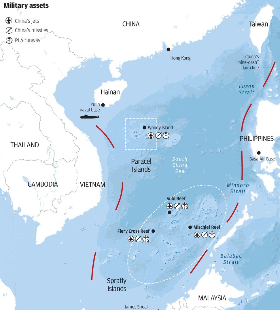
Chinese military assets in the South China Sea.
courtesy of SCMP
Aid and investment are deployed to buy obeisance from ruling elites in countries such as Cambodia, Laos and Brunei.
When larger and more open countries pursue unfavorable policies, Beijing threatens them with economic punishments.
That was the case against South Korea when Seoul decided to deploy America’s Terminal High Altitude Area Defense antiballistic missile system after North Korea conducted its fourth nuclear test in January 2016.
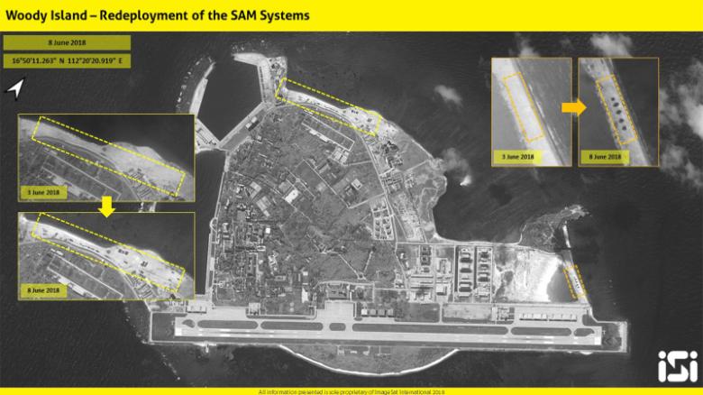
Satellite images provided to CNN on June 11 show before and after images of Woody Island.
About one-third of countries earmarked to take part in the flagship Belt and Road initiative are at risk of being unable to pay back the loans.
While countries such as Sri Lanka, Mongolia and Pakistan have been forced to concede to agreements on terms favorable to Beijing, the initiative is solidifying China’s reputation as a predatory partner.
These are poor and fragile foundations for aligning long-term interests and securing lasting loyalties.
New governments discard allegiances sold by predecessors, as is occurring in Malaysia.
Oppressive debt creates long-term resentments, as it has done in Sri Lanka.
Constitutional changes, which could allow Xi to become his country’s first “leader for life” since Mao Zedong, are hardly reassuring.
A return to one-man rule further reinforces widespread suspicion of China’s increasingly hierarchical view of the world.
Confused messages and noise emanating from the White House are unhelpful.
However, China is still an incomplete maritime power, and resistance against Beijing is on the rise.
The advantage remains with the United States.
The satellite carries one of the most sophisticated instruments ever to be put into orbit: Aladin, which includes two powerful lasers, a large telescope and very sensitive receivers.
The laser generates ultraviolet light that is beamed down into the atmosphere to profile the world’s winds – a completely new approach to measuring the wind from space.
These vertical slices through the atmosphere, along with information it gathers on aerosols and clouds, will improve our understanding of atmospheric dynamics and contribute to climate research.
As well as advancing science, Aeolus will play an important role in improving weather forecasts.
The mission will also complement information about the atmosphere being provided by the Copernicus Sentinel missions.
They say there is no gain without pain, but when the European Space Agency (Esa) set out in 2002 to develop its Aeolus satellite, no-one could have imagined the grief the project would bring.
Designed to make the most comprehensive maps of winds across the Earth, the mission missed deadline after deadline as engineers struggled to get its key technology - an ultraviolet laser system - working for long enough to make the venture worth flying.
But now, 16 years on, the Aeolus satellite is finished and ready to ship to the launch pad.
And far from being snuck out the back door at night in embarrassment at the huge delay, the spacecraft will be mated to its launch rocket with something of a fanfare.
Esa is taking pride in the fact that it overcame a major technical challenge.
"Many times I remember people saying, 'there's just no point in continuing because it is simply not possible to build a UV laser for space'. But this is the DNA of Esa - we do the difficult things and we don't give up," said the agency's Earth observation director, Dr Josef Aschbacher.
It helped of course that Aeolus promises data that many experts still believe will be transformative.
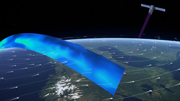
From its vantage point some 320km above the planet, the laser will track the movement of molecules and tiny particles to get a handle on the direction and speed of the wind.
Currently, we measure the dynamics of the atmosphere using an eclectic mix of tools - everything from whirling anemometers to other types of satellite that judge wind behaviour from the choppiness of seawater.
But these are all limited indications, telling us what is happening in particular places or at particular heights.
Aeolus, on the other hand, will attempt to build a truly global view of what the winds are doing on Earth, from the surface of the planet all the way up through the troposphere and into the stratosphere (from 0km to 30km).
How to measure the wind from space :
Aeolus will fire a laser through the atmosphere and measure the return signal
The light will scatter back off air molecules and particles moving in the wind
Meteorologists will adjust their numerical models to match this information
The biggest benefits should be in medium-range forecasts - a few days hence
Aeolus should pave the way for operational weather satellites with lasers
"The lack of wind profile observations is one of the most important gaps to fill in order to improve numerical weather prediction," Dr Florence Rabier, the DG at the European Centre for Medium-Range Weather Forecasts (ECMWF), told BBC News.
"The Aladin Doppler wind lidar instrument onboard Aeolus will be the first satellite instrument that provides wind profiles from space.
"We have very high expectations regarding the quality of the Aeolus wind profile data, and we are anticipating forecast quality to increase by 2-4% in the extra-tropics and up to 15% in the tropics. Aeolus is paving the way for significant improvements in weather forecasting".
There is an example that meteorologists quote from March 2014 - storminess that led to flooding in northern Europe.
When they did the post-event analysis to figure out why no-one had seen it coming, the conclusion was that inaccurate wind data six days previously had been used in the models.
Dr Alain Dabas from MeteoFrance explained: "The error was in the central Pacific at an altitude of about 11km. There was a mistake in the initial winds given to the models and that propagated to Europe.
"The question now is would Aeolus have solved this problem? Probably, yes."
It goes without saying that knowing what the wind is going to do reaches beyond just the nightly weather forecast on TV.
How it blows affects the distribution and transport of pollutants, and how quickly bad air in a hazy city, say, can be cleared away.
The first Doppler Wind-Lidar in Space
Aeolus will measure global wind speeds in horizontal slices up to 30 km above the Earth’s surface and improve the performance of numerical weather forecasts.
Aeolus will bring improvement for climate research and modelling.
Aeolus will be the first satellite capable of observing wind activity in our atmosphere using laser technology to produce dynamic 3D maps.
Then there are the requirements of safety to consider - think sailors at sea, or construction on high-rise buildings. And don't forget the sectors whose whole reason to exist rests on the wind.
"For instance, the wind energy industry," said Dr Anne Grete Straume, Esa's Aeolus mission scientist.
"They're exploiting the winds and they need to know how much energy they can produce at any point in time. For that they need very accurate forecasts and we hope that our mission can help them with their management."
But all this depends on the UV laser doing its job.
The engineers are very confident now that it can.
They recently put the finished Aeolus satellite in a space chamber for six months to simulate the conditions of being in orbit.
The whole system passed with flying colours.
It is worth recalling some of the past frustrations.
The first problem was in finding diodes to generate laser light with a long enough lifetime.
When those were identified, the mission looked in great shape until engineers discovered their design wouldn't actually operate in a vacuum - a significant barrier for a space mission.
Tests revealed that in the absence of air, the laser was degrading its own optics; as the high-energy light hit the lenses and mirrors, it would blacken them.
Companies across Europe were pushed to develop new coatings for the various elements.
The key breakthrough, however, was to introduce a small amount of oxygen to the instrument to prevent surfaces carbonising.
It's a tiny puff of gas - 40 pascals' worth; the same pressure you might expect to develop from the presence of a photosynthesising plant.
But it is sufficient to oxidise contaminants and remove them.
"When we started, the only references we had were classified because these types of lasers are used to represent atomic bombs, and those technologies were totally locked out," said Anders Elfving, Esa's Aeolus project manager.
"The motivation for my team all these years was that there is no alternative, and of course the user community is still so enthusiastic for what we've built.
"We want to see what is invisible - to see the wind in clear skies. And I think active lidars like Aladin are the future - for much more accurate measurements of CO2 and other trace gases in the atmosphere."
The launch of Aeolus on a Vega rocket is currently set for 21 August.