Thursday, August 18, 2016

Watch terrifying video of coral convulsing as seas heat up

Scientists from an Australian university say they have for the first time captured on video the coral bleaching process caused by rising sea temperatures.
Photo: Brett Lewis/Queensland University of Technology

From National Geographic by Mark Strauss

For the first time, time-lapse footage reveals the nightmarish horror of the heat-induced behavior known as bleaching.

Corals are dying in ocean reefs worldwide, the victims of abnormally hot waters warmed by El Niño and climate change.

Scientists have long known that higher ocean temperatures set off a biological reaction called bleaching.
Heat-stressed corals expel the colorful symbiotic algae that provide them with food, and in doing so, the corals turn bone white and face potential starvation.

Now, Australian scientists have captured these death throes on video—and it’s horrible to behold.
The researchers placed specimens of the coral Heliofungia actiniformis into aquatic tanks that simulate their natural environment, and then they turned up the heat.
The footage reveals that the corals eject the algae through a process called pulsed inflation.
They expand their bodies to as much as 340 percent of their normal size before violently contracting and spitting out the tiny organisms over a period of four to eight days. Seen in time-lapse video, the sea creatures turn paler with each convulsion.

In the short term, bleaching does have its benefits.
“The rapid expulsion of the coral's algal symbionts during thermal stress … could very well increase H. actiniformis's chance of survival during abnormally high sea temperatures," says Luke Nothdurft, one of the investigating scientists, in a press release.
That’s because, over time, the heat causes the symbiotic algae to become toxic, and expelling the algae keeps the coral alive.
But if the water doesn’t cool enough to allow new algae to quickly recolonize the coral, the bleached reef will die.

Signs of coral stress are already appearing around the globe.
In April, a comprehensive new map revealed that up to 93 percent of Australia’s famed Great Barrier Reef is suffering from the effects of bleaching.

Links :

Wednesday, August 17, 2016

A brief history of voyages through the Northwest Passage


The Gjøa expedition
Roald Amundsen’s expedition with the Gjøa was the first to navigate the Northwest Passage north of the Canadian mainland on one expedition and one ship.
In 1903-06 Amundsen accomplished this with six companions.
Two years were spent on the way in Gjoa Haven when the then-location of the North Magnetic Pole was established, proving that the Magnetic Pole moves over time.

From Time by Olivia B. Waxman

A cruise liner will tackle the route for the first time

On Tuesday, the luxury cruise ship Crystal Serenity begins a 32-day voyage carrying more than 1,000 passengers from Anchorage, Alaska, to New York City through the legendary Northwest Passage, which connects the Atlantic and Pacific Oceans through the Canadian Arctic Archipelago.
The vessel has been called “the first large-scale cruise ship packed with tourists” to “conquer” the 900-mile sea route that has been notoriously difficult to traverse due to its icy landscape and dangerous weather conditions.

In fact, European explorers spent centuries trying to find the passage in the first place.
James P. Delgado, Director of the Maritime Heritage Program at The National Oceanic and Atmospheric Administration and author of The Quest for the Northwest Passage, says the centuries-long quests started during the mini ice age of the Elizabethan era, in the mid-to-late 15th century, when “the English, desiring to reach the riches of ‘The Orient,’ figured they could find an oceanic shortcut through the Americas and not have to deal with Spanish-controlled waters, particularly in the aftermath the Treaty of Tordesillas,” which divided land discovered by Christopher Columbus between Spain and Portugal.


 Frobisher's first expedition left England in June 1576 and probably sighted what is now called Resolution Island (near Labrador) by the end of July.
Factors including poor weather would eventually force Frobisher west, but not before he entered the bay that now carries his name (Frobisher Bay) — though he believed it was a strait — on present-day Baffin Island.
There, he and his crew met the resident Inuit.
Relations soured between the European explorers and Inuit when five of Frobisher’s crew vanished after rowing to shore, apparently being taken captive.
Frobisher would never recover the men.
He then kidnapped an Inuit man, who had kayaked to the European ship to trade, and brought him back that fall to England, where the captive soon died.
Frobisher also brought with him a piece of ore and gave it to Lok, who believed it was valuable; an assayer later claimed that it contained gold.....

The list of failed attempts is a long one: Delgado says Martin Frobisher’s 1578 journey was the first major attempt, though the explorer ended up being sidetracked by false gold.
Henry Hudson would try in 1610, but end up in an area now known as Hudson Bay, which would later open up that part of the continent to the fur trade.
Explorers in the 17th century would mostly “poke and prod” around the Eastern approach until the American revolution and the War of 1812 when Britain ships and minds were diverted from exploration for the purposes of war.
After the war ended, explorer John Ross didn’t find the passage, but did find the North Magnetic Pole during his 1829-1833 expedition.
Captain Sir John Franklin and two ships carrying at least 128 men set off in 1845, then disappeared.

That disappearance, however, would prove to be a turning point: it “inspired expeditions to find him, and those search expeditions show there’s a passage through,” Delgado says.
(In fact, the search continued as recently as Sept. 2014, when Parks Canada discovered one of the two ships, the HMS Erebus.)

Robert McClure’s search expedition for Franklin would spot a passage via ice, but Norwegian explorer Roald Amundsen’s ship would be the first to go all the way through by water — East to West — between 1903 and 1906.
The Canadian schooner St. Roch would be the first ship to go in both directions in the early 1940s.

By the Cold War, things had changed.
The Arctic had become a “strategic frontier,” and the USS Seadragon made the first submerged passage in 1960, during a period when “Soviet and American submarines used it as a highway,” Delgado argues.
The 1969 voyage of the Humble Oil-sponsored SS Manhattan tanker would show “new commercial possibilities” by sailing through with icebreakers, along with accommodations so luxurious, TIME said it proved the Northwest Passage “could be tamed in style.”


 Experience the lure of Canada's high Arctic aboard an expedition cruise through the mythical Northwest Passage.

After the Cold War came an increase in ecological and cultural tourism, Delgado says, adding that “now with global warming, it is not same fearsome passage it was.”
One milestone was the summer of 2007, when TIME reported, “for first time in recorded history, the Northwest Passage was ice-free all the way from the Pacific to the Atlantic.”
Such conditions make trips like the Crystal Cruise possible and environmentalists worried about the long-term implications.
“Ice-free should bring a sense of horror to all because that means melting of so much ice that sea levels will be much higher,” says Delgado.
“You need to be careful what you wish for.”

Links :

Tuesday, August 16, 2016

8 maps show plastic’s impact on the world’s oceans — and what’s being done about it

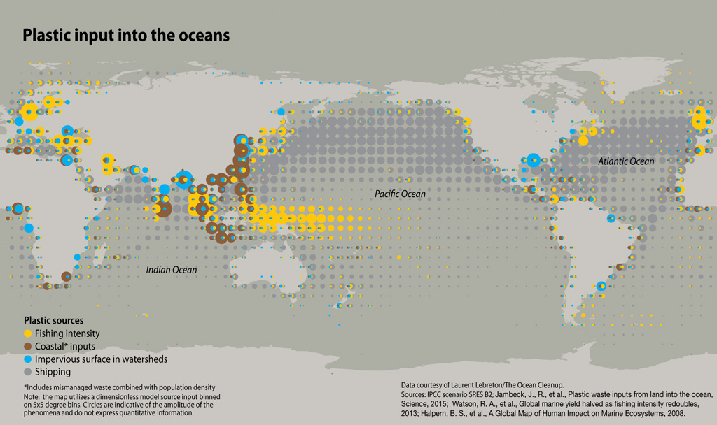
One of the major challenges of addressing plastic pollution in the world’s oceans is the fact that sources of entry are multiple and widespread.
Graphic by GRID-Arendal and Maphoto/Riccardo Pravettoni

From ENSIA by Todd Reubold

The world’s oceans are awash in plastic pollution, and as these maps and charts show, the situation is poised to worsen unless drastic changes take place.


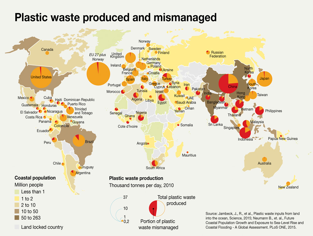
 Mismanagement
The global production of petroleum-derived plastic has increased dramatically, from 1.5 million metric tons (1.7 million tons) in 1950 to more than 300 million metric tons (330 million tons) in 2014. If the current production trend — approximately 5 percent increase per year — continues, another 33 billion metric tons (36 billion tons) of plastic will accumulate around the planet by 2050, further driving the need for better methods of collection and recycling.
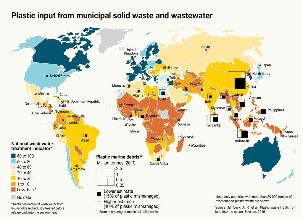
 Capturing Plastic at the Source
Not surprisingly, countries with limited wastewater treatment and municipal solid waste facilities often see larger amounts of plastic debris entering the ocean from their shores.
 Over the coming decades global plastic production is slated to increase nearly sixfold, and collection and recycling systems in many parts of the world already are struggling to keep up with the proliferation of plastic products and associated waste.

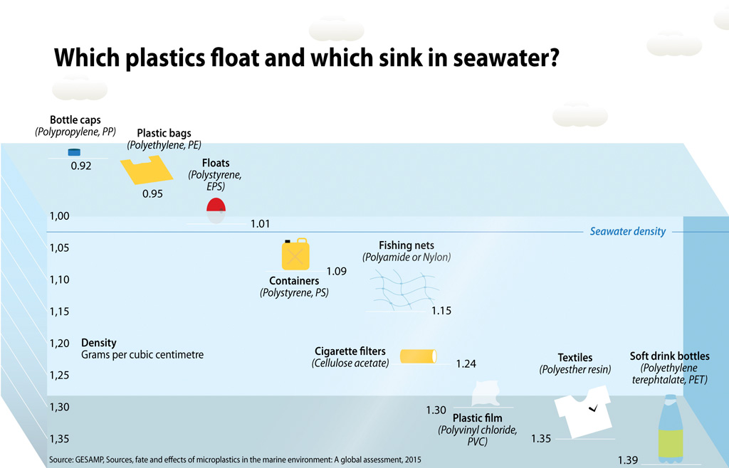
 Does It Float?
In terms of buoyancy, not all plastic is created equal. Absent from the graphic shown here are the ubiquitous fragments of micro- and nano-plastic plaguing the world’s oceans.

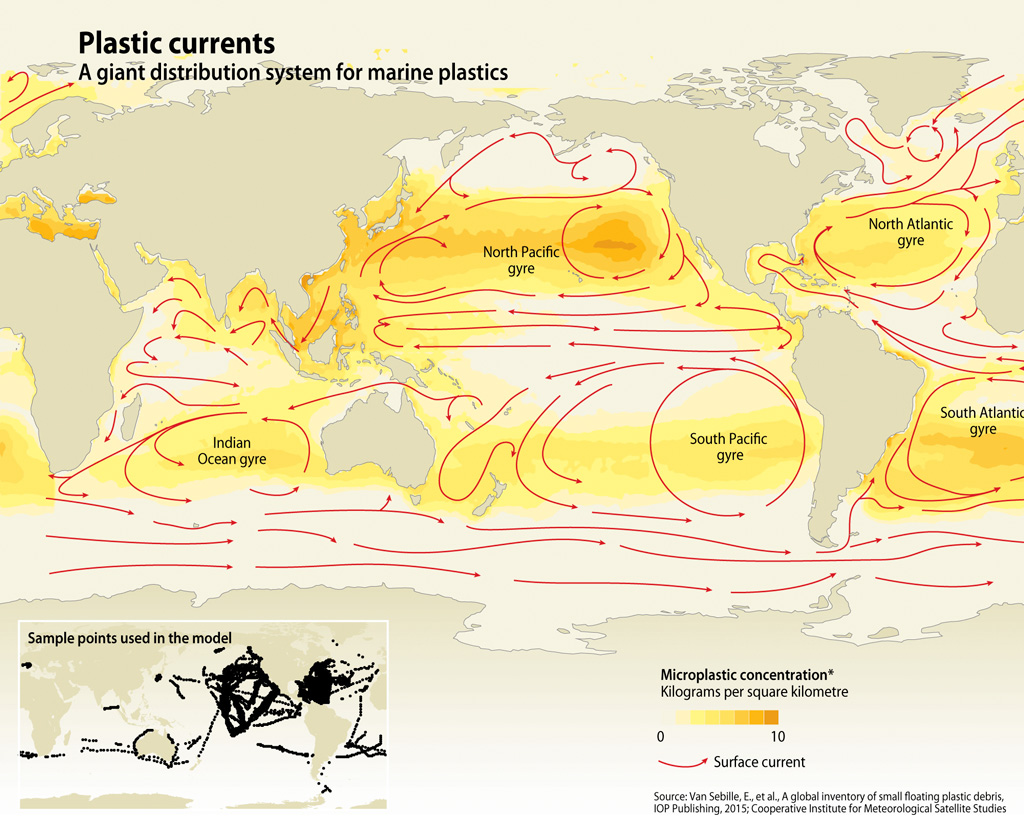
Plastic Currents
The geographic distribution of marine plastic debris is strongly influenced by the entry points and different ocean transport pathways, which are in turn determined by the density of plastic debris coupled with prevailing currents, wind and waves.

Broadly speaking, plastic pollution comes from three main sources: single-use applications such as food packaging and disposable consumer goods; long-lasting plastic items, including pipes and construction materials; and durable consumer products such as electronics and furniture.

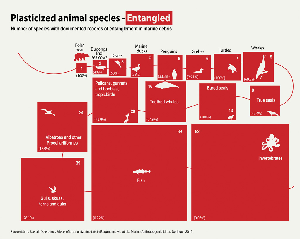
Entangled Marine Life
Entanglement can cause death due to drowning, starvation, strangulation, or cuts and injury that cause infection.
Much of the damage to marine life of this nature is caused by discarded fishing equipment — so-called “ghost fishing.”
Studies of scarring on whales from the Gulf of Maine indicate that more than 80 percent of right whales and 50 percent of humpback whales have experienced entanglement in fishing gear.

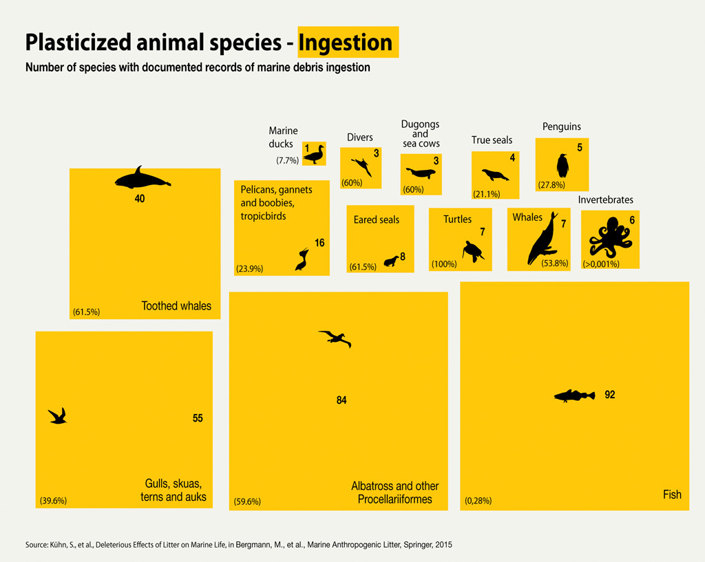
Marine Debris Ingestion
The ability of plastic particles in the ocean to attract organic chemicals that don’t dissolve, which include many well-known toxic substances, has led to a growing number of studies looking at plastics as a source of toxic chemicals in marine organisms.

The impacts of plastic — and in particular, microplastic — on marine life can be devastating. Hundreds of species of seabirds, turtles, seals, sea lions, whales and fish have suffered entanglement or death due to plastic pollution in recent decades.

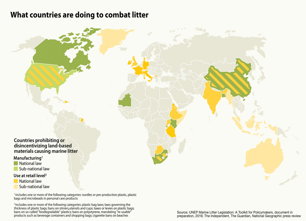
 The Way Forward
Legislation and policies aimed at reducing the release of litter on land and at sea,will help reduce the amount marine debris entering the world’s oceans.

This collection of maps and charts prepared by Norway-based GRID-Arendal — a United Nations Environment Programme affiliate and partner with a mission of creating environmental knowledge to enable positive change — explains how plastic ends up in the world’s oceans and explores steps being taken to reverse this trend.

Links :

Monday, August 15, 2016

Baie de Morlaix


Bay of Morlaix with the GeoGarage platform (SHOM chart)

Sunday, August 14, 2016