Tuesday, June 10, 2014

South Georgia: The lost whaling station at the end of the world


From BBC

Once British sailors were a big part of the whaling industry in the southern hemisphere.
Now only rusting buildings and ship skeletons remain, where once thriving whaling stations were, writes Adam Nicholson.
The abandoned whaling station at Leith Harbour on South Georgia in the south Atlantic looks as if it has been bombed. Rusty steel chimneys lie collapsed across the roadways.
Power plants and dormitory blocks lie half-smashed, their innards spilling out through the walls - cast-iron beds and baths, piping and wiring, cushions and mattresses all now leaking into the freezing air.
Some of the huge steel cylinders of the whale oil tanks, 30ft high and 30ft across, have had their sides folded in, as if by a giant hand.
But these are just the effects of time and the brutal winds of the Southern Ocean.


Uncover the story of Britain's Whale Hunters and the whales nearly driven to extinction

It is not somewhere you would ever like to be alone.
The winds that hurl off the mountains of this sub-Antarctic island, 800 miles east of the Falklands, on the same latitude as Cape Horn, make the whole place creak and groan.
Rusted corrugated sheets screech against their fixings, doors slam open and shut, the ventilator cowls on the giant processor plants still turn in the wind as they have done since the place was finally abandoned and left to the elements in 1965.
No-one is there now because Leith Harbour, like most of the other whaling stations on South Georgia, is strictly off-limits.
The collapsing structures are too dangerous and the asbestos in which the whale processing machinery is still wrapped makes the enclosed places too toxic.
The South Georgia government - this is one of Britain's few remaining overseas territories - had to give us permission to film in this breathtaking time-capsule of a forgotten way of British life.
And we had to be accompanied by Tommy Moore, a Yorkshireman familiar with asbestos safety, and dressed in full protective gear.


Pick your way through the buildings now and you find yourself in a forgotten world - mounds of harpoon heads lying rusted together, whale ribs and scapulae everywhere, abandoned tractors and rusted lathes.
In the manager's villa, graffiti tells of Argentine joy in 1982 at recovering their own, every word of it covered with the unequivocal responses of the crews of Royal Navy ships who arrived a few weeks later.
Snow clogs the doorways of the cinema where the whalers used to watch over and over again the few films they had, the dust-filled hall still filled with memories of Elizabeth Taylor and Deborah Kerr.
The hospital still has unopened bottles of milk of magnesia and tins of Prickly Heat Powder on the shelves of its half-trashed pharmacy.
Stinking fur seals lurk in the radio shack and among the overturned benches of the canteen. In the dormitories, the whalers' pin-ups still smile winsomely from the walls.
Hidden in attic spaces you can find the bowls, ladles and tins of yeast with which the whalers made the fearsome hooch to console themselves on long winter evenings 8,000 miles from home.

Stromness Bay with the Marine GeoGarage (UKHO chart)

The whole place is a monument to a huge and massively destructive episode in British history.
By the beginning of the 20th Century, whaling had virtually eliminated the stocks of whales in much of the northern hemisphere.
Europe had a growing appetite for the oils that whales could provide - most of it for margarine and soap - and the vast stormy waters of the Southern Ocean beckoned, teeming with krill and with the whales that fed on it.

“He is seldom seen; at least I have never seen him except in the remoter southern seas.”
Even by the beginning of the 19th century, whales were beginning to disappear from some coastal waters, and hunters had to travel further to make a living.
In 1871, 32 vessels were lost when they became trapped in the arctic ice.

Almost entirely fuelled by British finance, the whalers came south and embarked on a bonanza that lasted for two-thirds of the century.
Individual whalers made the kind of money they could only have dreamed of at home.
A young man returning to Shetland or the Hebrides in the 1950s after 18 months "at the ice" could buy a house, start a business or commission a fishing boat on his earnings.


Christian Salvesen, the Edinburgh-based whaling company that built Leith Harbour, could hope in some years for 100% dividend on their investment.
At the peak of the business in the 1920s, Salvesen's were making the equivalent £100m a year in profit in today's money.
None of it was easily earned.
The conditions were brutal.
Ice often clogged the rigging and individual catching boats were known to founder in the steep seas of the southern ocean.
Earnings were dependent on the number of whales caught and the skipper-gunners drove boats and crews relentlessly.
When the enormous bodies of the whales were hauled ashore into the huge processing plants, an army of men got to work, working 12-hour shifts, stripping the blubber from the carcasses, "like peeling a banana", as the whalers all say, shovelling the meat into the giant cookers, cutting up the bones with enormous steam saws and boiling them up for the oil they contained.
An entire whale, the size of a railway carriage, could be disposed of in 20 minutes.
If newly caught, there were consolations: "You could warm your hands in the fresh blood," Jock Murray, a whaler from the Hebrides remembers.
"If it was a week old, that was something else."


It is difficult to recover the frame of mind in which the destruction of so many of the greatest animals on earth seemed like a good idea.
About 1.6 million whales were killed in the Southern Ocean in about six decades.
The whalers remain deeply ambivalent about it today.
Many say they are proud to have done it but wouldn't do it now.
There are other ways, largely through plant extracts, of getting equivalents of the oils once taken from the whales.
But, as one of the whalers, John Alexander, says: "We thought we were doing some good for the country."
They were garnering fats which Britain desperately needed, particularly in the years after World War Two.
It was a difficult task, at which they became immensely skilled.
And as boys from crofts or fishing families in marginal parts of Scotland, they were providing for themselves in a way little else could have.

 Whale hunters in South Georgia in 1935

Monday, June 9, 2014

Arriving at St Helier harbour


Commodore Clipper arriving at St Helier harbour and berthing on the Elizabeth Harbour west berth.


Condor Rapide arriving into St Helier harbour and berthing onto the Elizabeth Harbour east berth

 Saint Hélier harbour, Jersey with the Marine GeoGarage

Sunday, June 8, 2014

World Oceans Day


The World Oceans Day 2013 & 2014 theme is "Together we have the power to protect the ocean".


Planet Ocean [UK]- the film by Yann Arthus-Bertrand

Links :

Saturday, June 7, 2014

Robby Naish surfing on the Amazon


From GuinnessBook

The famed Pororoca tidal bore on Brazil's Amazon River is no easy beast to tame.
When the tide hits the confluence of the Amazon and the Atlantic Ocean just right, it results in waves up to 4 m (13 ft) high that can travel for hundreds of kilometers.
This tidal bore has earned a reputation as a surfing hotspot, drawing some of the world's best to ride the Pororoca for some length.
But anybody can ride waves downstream.
Robby Naish prefers going against the grain.

"Five hour flight to LA, 11 hour flight to Sao Paolo, 3 hour flight to Sao Luis, then a three hour drive to a river 80 kilometers inland from the Atlantic coast to SUP a Pororoca tidal bore wave!Only one wave per day for three days, but the longest rides I have ever had."

The famed water sports athlete, with the backing of Red Bull, recently broke the record for the widest ride of a river bore on a stand-up paddleboard (SUP).
Cutting across the daunting tide, Naish paddled 450 meters (1,476 ft 4 in) over the Arari Pororoca, crossing from bank to bank.
Naish has enjoyed a long and storied career on the water.
A 24-time world windsurfing champion -- winning his first world title at age 13 in 1976 -- Naish has also branched out to kitesurfing and now SUP since retiring from competition.


Due to its tidal dependency, the bore appeared at a different hour each day, with Naish beginning his daily preparations at 6 a.m. across three days of attempts.
“The main challenge with the width record was trying to get from one side to the other as the bore tide wave shifts, because it is never connected all the way across at once," Naish said afterward.
"You weren’t just standing there riding one peak for ages. You had to look at the contour of the side of the river and figure out what to do to follow the wave."


Naish completed his 450-m crossing in just under 10 minutes.
He caught his record-breaking wave at 8:38 a.m.
Many times an unofficial world record holder for high speeds and other categories in his windsurfing days, this successful attempt marks Naish's first fully authenticated Guinness World Records achievement.


"This was the first time anyone has organized an actual challenge and record that we were trying to achieve," Naish said. "It was neat and exciting, sort of opens the door for opportunities to think about more things that could be attacked from that perspective."
And, if you ask the 51-year-old, he isn't done breaking records yet.
Whether or not they have anything to do with board sports is a different story.
"There are definitely possibilities out there with all the things that I do, so I’m going to have a look," Naish concluded.
"I’m definitely going to pull the Guinness World Records book out again and look at what the options are. Grow a big beard or something."


"A lot of people call me ‘Waterman’," Naish said.
"But I see myself as a 'board' person. It doesn't matter if it's surfing, windsurfing, kitesurfing, stand-up paddle, skate, or snowboard. I love the feeling of gliding, whether on water or some other surface."
Having competed around the globe in his career, Naish received a unique challenge on the Amazon, as the combination of river movements, heat, and the particularities of the massive ecosystem made the attempt a tall task.
The fickleness of the bore itself played a major role, for instance.

Friday, June 6, 2014

Mapping out a vital part of D-Day history

From the June 19, 1944, issue of TIME. (TIME Magazine)

From Wilts&GloustershireStandard by Brendan McFadden

ON June 6, 1944, Operation Neptune marked the beginning of the invasion of German occupied Europe by the Allied Forces under the command of General Dwight D. Eisenhower.

The Second World War invasion on the Normandy coast of France became commonly known as D-Day, and was the largest amphibious assault ever executed, involving five army divisions supported by over 7,000 ships and 11,000 aircraft.

Plans for D-Day were underway months in advance.

It is a little known fact that American regiment, the 654th Engineer Topographic Battalion, which was based in Tetbury (UK), had a key role in the success of the invasion, which was a major turning point of the war.
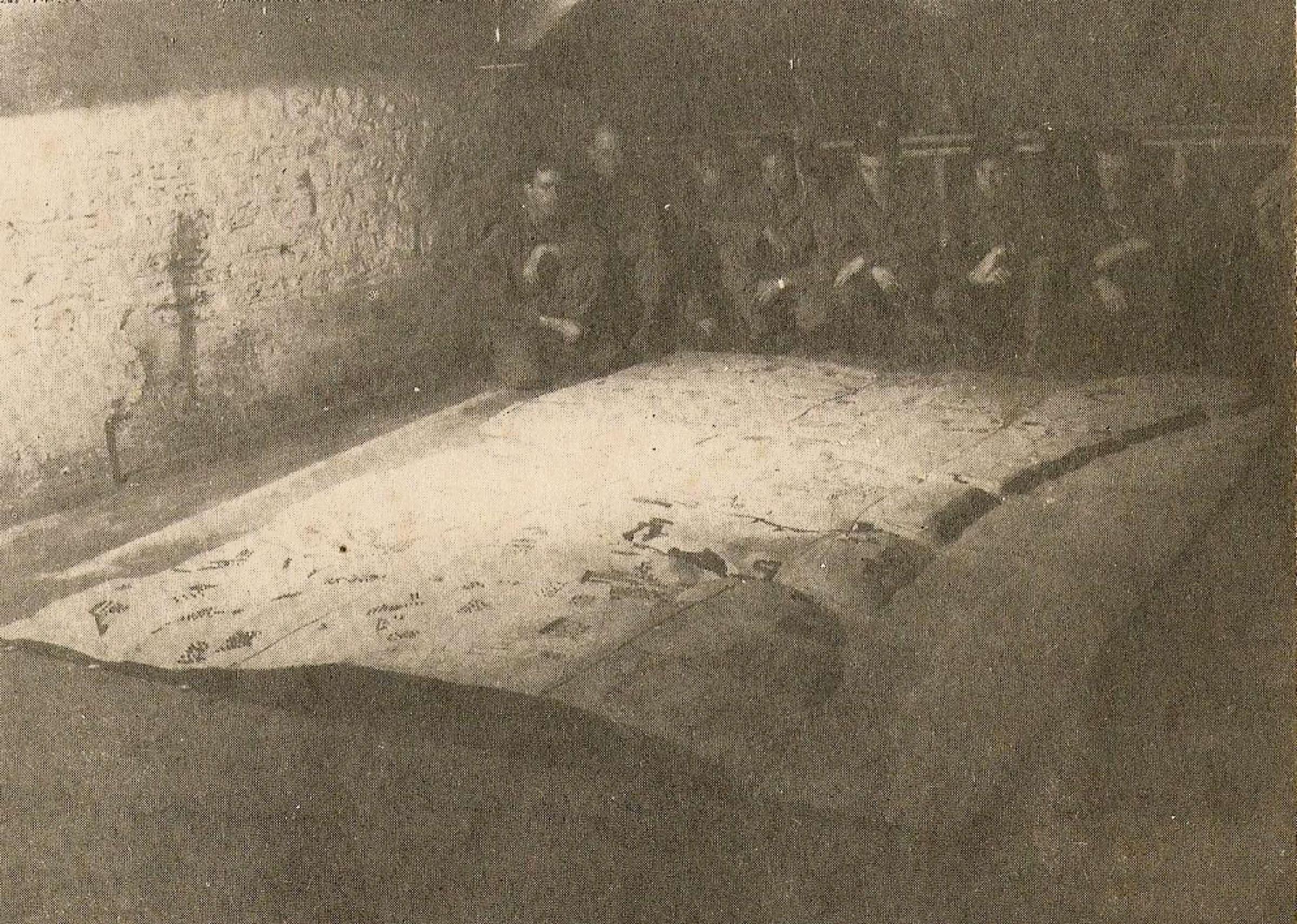
As part of a top secret project, the Tetbury-based troops devised a 3D map of Omaha Beach which became a vitally important tool used to capture the beach and move inland.

Troops with the 3D map of Omaha beach which they made at the Old Malthouse in Tetbury

Tetbury historian, Merlin Fraser has researched the work of the 300-man regiment, uncovering how they produced eight million ordinance maps, which helped American troops plot their route to Germany following D-Day.

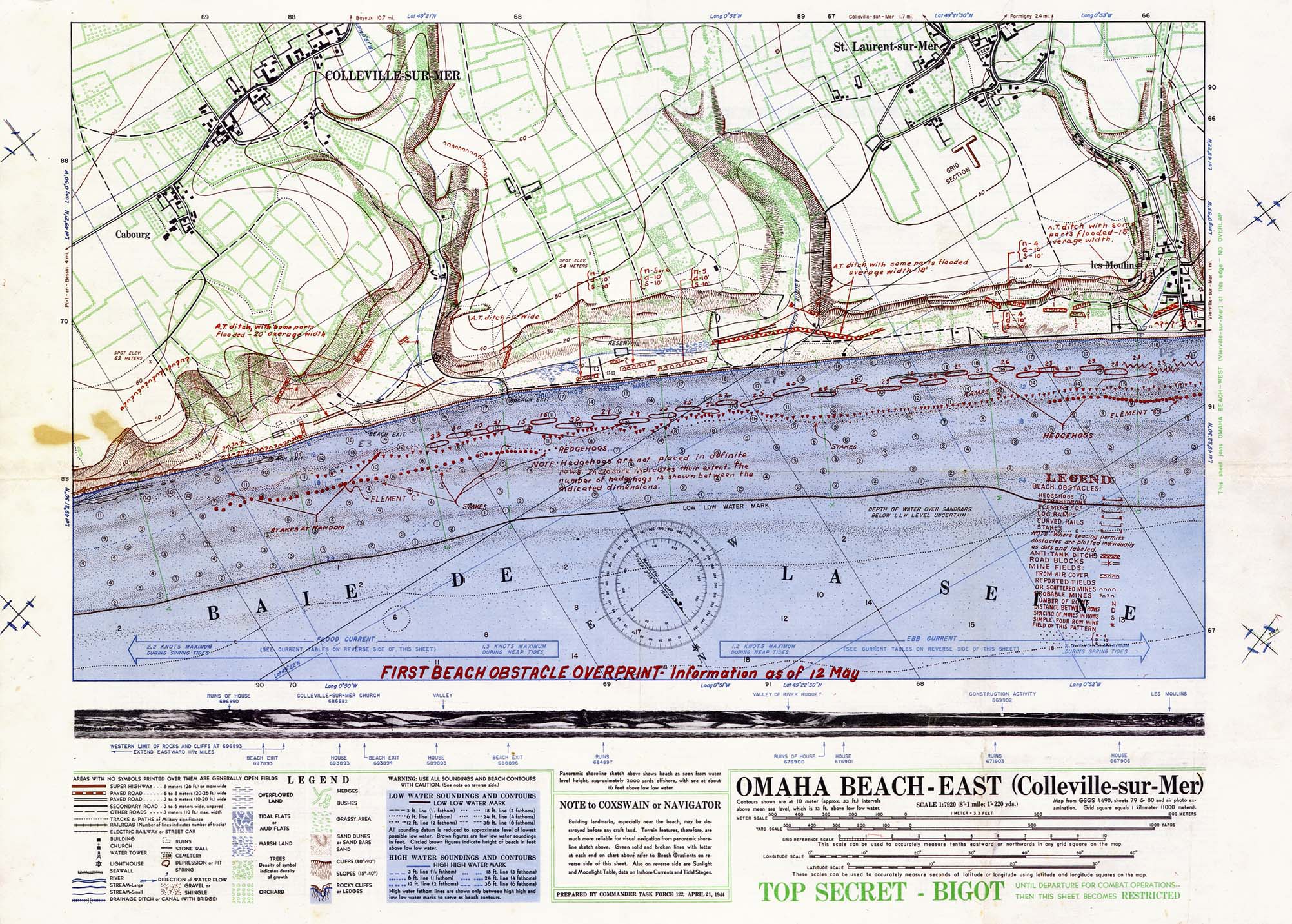
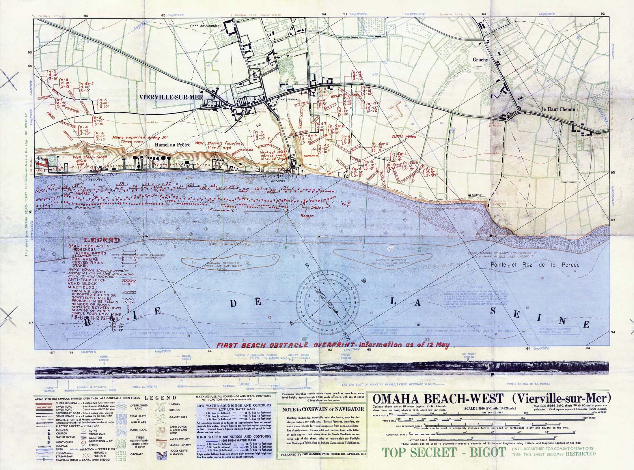
 Omaha beach detailed
(other : Utah beach)

Merlin is documenting his findings in a book called the Americans in Tetbury and together with Tetbury Town Council he has worked to install a plaque in the town to commemorate both the 70th anniversary of D-Day and the GI’s work in the town.
“In the grand scheme of all things historical what happened in the small Cotswold market town of Tetbury during the six months prior to those landings paled into obscurity overshadowed by the true horrors of war and what happened on those beaches that day,” Merlin said.
“The American soldiers stationed here were not front line troops and they were not part of that first day, however the work they did was of vital importance to the preparation, planning and execution of both Operation Neptune and Overlord.
“In a nutshell I guess you could say that these troops were part of the ‘Back Room Boys’ of Military Intelligence.”

 Wilts and Gloucestershire Standard: Soldiers from the battalion assemble maps
in a trailer in Berlin as part of the American’s march to Germany

The plaque, in the north-east corner of the Chipping car park, will look towards the old Malt House, where the 3D model of Omaha was created.
It is being unveiled on Friday, June 6 at 11am by Tetbury mayor Sandra Ball.

Aerial photo shows troops landing on D-Day at Sword Beach, France on June 6, 1944.
(British Ministry of Defense)
The battalion was split into three sections.
Company A, was based in and around the town, including the Old Malt House and was responsible for turning aerial reconnaissance into maps.
Company B was based at nearby Chavenage House and printed the maps.
Headquarters and the battalion’s officers were also based there.

Left : weather maps for 1,2,3 June 1944 at 1300GMT
Right : weather maps for 4 June 1300 GMT and 6 June 0600 GMT
(History of meteorology, James Fleming)


Chris Tubbs Deputy Chief Forecasters at the Met Office UK uses original weather charts for the day of the invasion, Tuesday the 6th of June.
He shows how there were brisk, north westerly winds coming across the country.
However some shelter from the wind and waves was provided in the Channel, enabling the allied, invasion troops to land successfully in Normandy.

In total, 75,215 British and Canadian troops and 57,500 US troops stormed the beaches on D-Day. with 23,400 landing from air by parachute or glider.

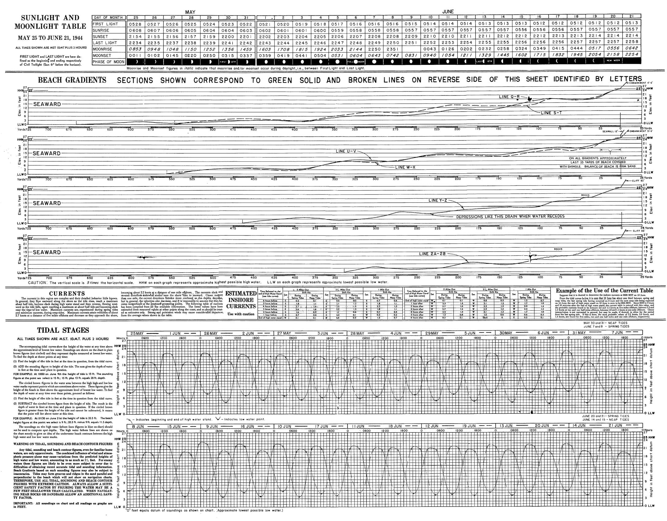
Prepared by the Commander Task Force 122, April 21, 1944.
"Map from GSGS 4490 Sheets 79 and 80 and air photo examination. Grid square equals 1 kilometer (1000 meters)."
Original scale 1:7,920.
"TOP SECRET - BIGOT Until Departure for Combat Operations -- Then This Sheet Becomes RESTRICTED".

After the Normandy Beaches success, the 654th Battalion followed the army across Europe, taking their survey, mapping and printing skills with them.

 'Approaches to Arromanches les Bains'.  A chart produced by the UK Hydrographic Department in July 1944 showing the layout of the harbour and soundings collected by HM Motor Launch 1001, the inshore survey vessel assigned to Mulberry B.

A photo mosaic from August 1944 showing an overview of Mulberry B as it was when in service.
(UKHO)

Merlin explained: “Omaha was the kick-off point but the maps were basically used for any theatre as they advanced." They resurveyed the area as they were advancing.”

Links :
  • Gigapan : D-Day map used by the allied forces to plan and execute the D-Day landings.
  • AppStore : D-day Hour by Hour
  • DailyMail : 'Port Winston' Mulberry harbour built off Normandy after D-Day is uncovered on the seabed 69 years later
  • CCOM UNH : High-Resolution Multibeam Sonar as a Tool for Archaeological Investigations: An Example from the D-Day Beaches of Normandy
  • UKHO : The Mulberry Harbours
  • Dassault Systems : D-Day Landings in 3D Virtual Reality