Tuesday, March 20, 2012

Deep ocean mysteries and wonders


In the deepest, darkest parts of the oceans are ecosystems with more diversity than a tropical rainforest.
Taking us on a voyage into the ocean -- from the deepest trenches to the remains of the Titanic -- marine biologist David Gallo explores the wonder and beauty of marine life.

David Gallo works to push the bounds of oceanic discovery.
Active in undersea exploration (sometimes in partnership with legendary Titanic-hunter Robert Ballard), he was one of the first oceanographers to use a combination of manned submersibles and robots to map the ocean world with unprecedented clarity and detail.
He was a co-expedition leader during an exploration of the RMS Titanic and the German battleship Bismarck, using Russian Mir subs.
On behalf of the Woods Hole labs, he appears around the country speaking on ocean and water issues, and leading tours of the deep-ocean submersible Alvin.

Links :

Monday, March 19, 2012

Surging seas maps sea level rise in Coastal U.S.


Interactive map to our city's future under the sea. Type in your zip code to see the flood risks of from rising sea levels and storms near you.


A new online site called Surging Seas from Climate Central maps the impact of climate change and sea level rise in coastal areas of the United States.


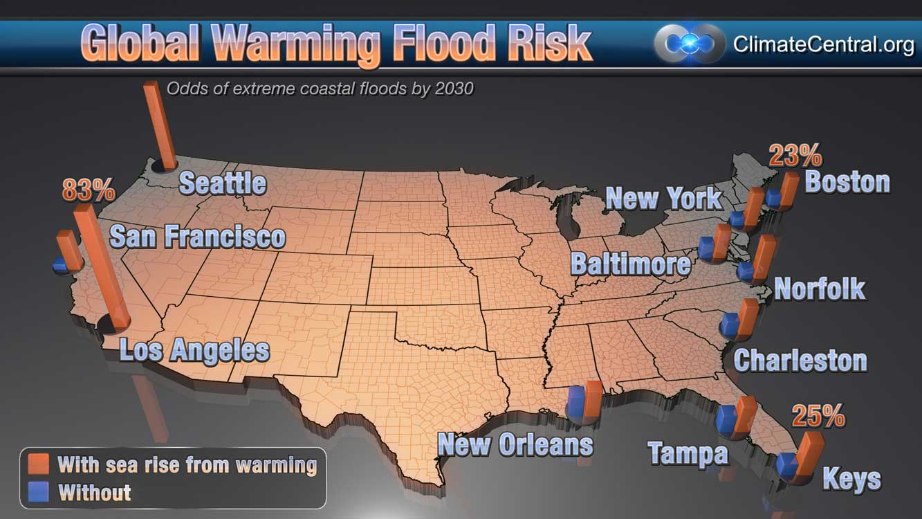
This map shows the odds of floods at least as high as historic once-a-century levels, occurring by 2030, based on Climate Central research.
The two bars extending from each study point contrast odds estimates incorporating past and projected sea level rise from global warming (red bars), and odds estimates not incorporating this rise (blue bars).
The century flood heights used for reference in these calculations are based on historic records, and expressed relative to sea level in 2009 to account for continually rising seas.

The online and interactive map displays the potential impacts of 2 to 7 more feet of sea level rise that is possible this century, which will impact the nearly 5 million people that live at less than 4 feet above high tide.

The map accompanies a report that looks at the impact of sea level rise and the risk from storm surges, with an estimate of the land, housing and population that are vulnerable.


A few shocking statistics from the report include:
  • In 285 municipalities, more than half the population lives below the 4-foot mark
  • In 676 towns and cities more than 10% of the population lives below the 4-foot mark

The Surging Seas website includes maps, reports, fact sheets, as well as downloadable data for all the cities, counties and states studied and links to dozens of local, state and national planning documents for coping with rising seas.

Links :
  • LiveScience : 4 Million Americans threatened by rising seas
  • NYTimes : Rising sea levels seen as threat to coastal U.S.

Sunday, March 18, 2012

To the Arctic - 3D documentary movie


An extraordinary journey to the top of the world, "To The Arctic 3D" tells the ultimate tale of survival.


Narrated by Oscar® winner Meryl Streep, the film takes audiences on a never-before-experienced journey into the lives of a mother polar bear and her twin seven-month-old cubs as they navigate the changing Arctic wilderness they call home.


Captivating, adventurous and intimate footage brings moviegoers up close and personal with this family's struggle to survive in a frigid environment of melting ice, immense glaciers, spectacular waterfalls, and majestic snow-bound peaks.

Saturday, March 17, 2012

Living the dream surfing Byron Bay

Byron Bay - The Meeting Place 'Trailer' from Rest Your Eyes

Thousands of years ago the Arakwal Aboriginal people recognised the rich beauty of the Byron region.
They called it Cavanbah ‘The Meeting Place’.

Located on the most easterly point of Australia’s unique coastline, Byron Bay slowly developed into a small sleepy whaling town and has now grown into one of Australia’s biggest tourist destinations with millions of visitors each year.

>>> geolocalization with the Marine GeoGarage <<<

‘Byron Bay – The Meeting Place’ is a beautiful and visually appealing 40-minute documentary that explores the journey Byron Bay has taken, and introduces the characters that have enriched the region’s culture; locals, hippies, surfers, travelers, indigenous folk, and people from all walks of life.
These people are all united by one factor, their love for Byron Bay.


The smooth surfer Jorgelina "Lina" Reyero hails from a small town on the Atlantic Coast of Argentina.
She's spent the last 6 years wandering the world with her surfboard in tow and has wound up near the beautiful Wategos Beach, 1,5 km East of Byron Bay town.
She mounted a little camera to the nose of her log and captured the beauty of an empty surf.

Friday, March 16, 2012

Wishful Mapping: a half-baked Alaska, and the passage that wasn't there

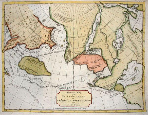
General Map of the Discoveries of Admiral de Fonte (detail version)

From BigThink

What a strange concoction this late-18th-century French map is.
Centred on the northwestern part of America, it is an eclectic mix of geographic fact and fiction. Some continental contours are instantly recognisable, for instance the Kamchatka peninsula of Russia’s Far East, and Canada’s Baffin and Hudson Bays.
But what is that thing in between, and what has it done to Alaska?

Even the mapmaker must have known there was something wrong with what he wrought.
Notice the contrast between the mostly soft-edged shores of this half-baked Alaska (
And of the wholly fictional islands to its north, floating in the Mer de Tartarie and inhabited by the mysterious Ye-Oue, or Nation des Pygmies. In the Middle Ages, 'Tartary' described all lands east of the Urals, little known in the West.), and the jagged coastlines of the real parts of the world.

Most of it corresponds to what we now consider to be Siberia (i.e. the Asian part of Russia).
The lack of detail for the former is intentional, a sign of deference by the cartographer to his lack of knowledge.
Smooth shorelines are a code between the maker and reader of maps, to be read as: Not yet surveyed.

Then take a look at the larger shape of this alternate Alaska, to the islands populating its northern shores, and to that strange strait that connects Pacific to Atlantic, while skirting both aforementioned Canadian Bays.
They’re proof of a curious constant in mapping fake geographies: even though imaginary islands, rivers and coastlines are as random as real ones, they mostly look like the fantasies they are. There’s just something inimitable about the haphazard quality of truly natural geography.

This map appeared in the third volume of
Diderot’s Encyclopédie as Didier Robert de Vaugondy’s version, dated 1772, of an English map by Thomas Jefferys (1768).
It purports to be a
General Map of the Discoveries of Admiral de Fonte, representing the great probability of a North-West Passage.


This was a popular map, as the Northwest Passage was a popular fantasy - and a prime example of wishful mapping.
The Passage found its origins in the early days after discovery, when America was still seen by Europeans as an obstacle to trade with China and Japan, rather than as an opportunity in its own right.
Its existence was first mooted in 1539 by
Francisco de Ulloa, whose voyage up the Gulf of California (the narrow body of water separating Baja California from the rest of Mexico. This peculiarity also prolonged the belief that California was, in fact, an island.) led him to propose that it was one end of a strait that ran all the way across the North American continent to the St. Lawrence River, flowing from the Great Lakes through Québec into the Atlantic.

This waterway, all the more mythical for being non-existent, started showing up on maps from the mid-16th century onward as the Strait of Anian, probably after a Chinese province mentioned in
Marco Polo’s Travels (where Anian and Toloman were mentioned together in such a way as to suggest that the former was Japan, the latter Kamchatka).
For centuries, it was one of that handful of fictional drivers of real exploration.
Others include the
Seven Cities of Gold (in North America) and El Dorado (generally sought in South America).
These places were always sought after but never found, and thus instrumental in pushing back the boundaries of the unknown.

The
Strait of Anian (or, as the British preferred to call it, the Northwest Passage), was the elusive prize of Sir Francis Drake’s visit to the North America’s West Coast (or, as he called it, Nova Albion (‘New Britain’)) in 1579.
In 1592, the Greek-born, Spanish-employed
Juan de Fuca (that’s Ioannis Phokas to his dear old mum and dad, but also sometimes Apostolos Valerianos. It’s not exactly clear to whom) claimed to have found it.
In reality, he probably sailed up the strait between Vancouver Island and the Olympic Peninsula that would later be named in his honour.

In 1609,
Henry Hudson ventured up the river that would be named after him, in search of the eastern terminus of the Northwest Passage.
He died a few years later, set adrift up north with his son and a few others by his mutineering crew into the icy bay that would later also bear his name.

An apocryphal Spanish tale has the Spanish admiral Bartolomeo de Fonte actually sail through the waterway in 1640, meeting a trading ship out of Boston that came in from the other side.

In the 1770s,
Captain Cook sailed up and down the coast of the Pacific Northwest, searching in vain for the entrance to the Strait of Anian.
His was the last, most vigorous attempt to do so.

The numerous, ever more northerly, and often deadly attempts to effect a Northwestern Passage were finally crowned with success in the early 20th century.
It took
Roald Amundsen three years (1903-1906) to make the crossing.

Too much ice and too shallow waters have always rendered this Northwest Passage uneconomical, but global warming might be changing that.
When the ice retreats far enough, the mythical waterway may yet become a reality, and finally connect the markets of the Old World with the fabled riches of Cathay and Xipangu (
China and Japan, if you were Marco Polo).