
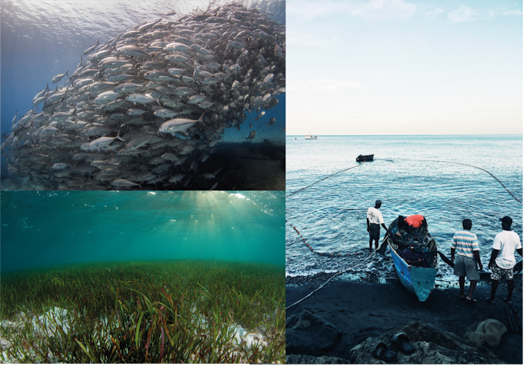
Photo by Steve Spence, National Geographic Pristine Seas
From National Geographic by
The first-of-its-kind study reveals that the world’s most
strongly protected marine reserves successfully curb industrial fishing
activity, offering a new way to assess fishing compliance and bridge
blind spots in current monitoring methods.
New peer-reviewed research in the journal Science demonstrates the power of strict legal bans against industrial fishing in marine protected areas (MPAs).
The analysis — which combines satellite imagery and artificial intelligence technology to detect previously untraceable vessels — reveals that most of the globe’s fully and highly protected MPAs successfully deter illegal fishing. The study is the first of its kind to demonstrate that the most strictly protected marine reserves are well respected and are not simply “paper parks.”
The study, “Little-to-no industrial fishing occurs in fully and highly protected marine areas” finds that:78.5% of the 1,380 MPAs studied had no commercial fishing activity;
Of the MPAs where satellite images detected illegal fishing activity, 82% of them averaged less than 24 hours of activity per calendar year;
Strongly protected MPAs had, on average, nine times fewer fishing vessels per square kilometer than unprotected coastal areas; and
MPAs designated as strictly-protected with significant fishing activity included those in the Chagos Marine Reserve, the South Georgia and South Sandwich Islands and the Great Barrier Reef Marine Park (combined with the Great Barrier Reef Coast Marine Park), each with approximately 900 hours per year.
“Because strictly protected marine areas discourage illegal fishing, fishes are far more abundant within their boundaries, they produce more offspring, and help replenish surrounding areas,” remarked Enric Sala, one of the study’s co-authors, a National Geographic Explorer in Residence, and founder of Pristine Seas.
Marine protected areas enable fish populations to recover, protect carbon sink habitats such as seagrass beds, and can protect non-industrial activities such as artisanal fishing and scuba diving.
Jeff Hester, Umeed Mistry, Hugh Whyte/Ocean Image Bank, Provided by the author
“In other words, the fishing industry benefits from following the rules.”
Illegal fishing poses a significant global threat, jeopardizing both the health of ocean ecosystems and the economic stability of the fishing industry. Scientific evidence shows that strictly protected MPAs restore marine life within their boundaries, improve local fishing, provide jobs and economic benefits, and build resilience against a warming ocean.
Illegal fishing poses a significant global threat, jeopardizing both the health of ocean ecosystems and the economic stability of the fishing industry. Scientific evidence shows that strictly protected MPAs restore marine life within their boundaries, improve local fishing, provide jobs and economic benefits, and build resilience against a warming ocean.
But when MPAs are minimally or lightly protected, the benefits practically disappear.
“The ocean is no longer too big to watch. With cutting-edge satellites and AI, we’re making illegal fishing visible and proving that strong marine protections work,” said Juan Mayorga, a scientist with Pristine Seas and co-author of the study.
To arrive at their conclusions, researchers analyzed five billion vessel positions from the Automatic Identification Systems (AIS), a GPS-based safety signal transmitted by many industrial fishing vessels, and paired this with satellite images generated by Synthetic Aperture Radar (SAR), which can detect vessels regardless of weather or light conditions.
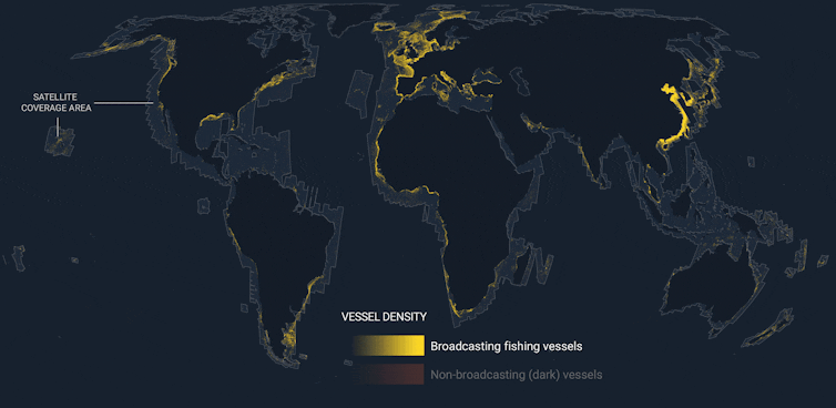
Global Fishing Watch analyzed millions of radar satellite images to determine the location of vessels that remain invisible to public surveillance systems.
On this 2022 map, vessels that publicly broadcast their GPS position via the AIS system are shown in yellow, and those that do not broadcast but have been detected via satellite imagery are shown in orange.
Global Fishing Watch, Provided by the author
The combination of the datasets — and the use of AI models developed by Global Fishing Watch — allowed researchers to detect the majority of fishing vessels over fifteen meters long, including so-called dark vessels that do not broadcast their location and often operate to evade detection.
“No single dataset can solve the challenge of monitoring fishing activity at sea; each has its blind spots,” asserted Mayorga.
“No single dataset can solve the challenge of monitoring fishing activity at sea; each has its blind spots,” asserted Mayorga.
“But when we combine them, their power emerges.
By fusing AIS tracking with satellite radar imagery and AI, we are now much closer to the full picture of human activity across the ocean.
That’s especially important in the crown jewels of the ocean — the world’s most strongly protected areas — where the stakes for enforcement and biodiversity are highest.”
Researchers found that the AIS data missed almost 90% of SAR-based fishing vessel detections within these MPAs. Inaccurate data, limited resources and the vastness of the ocean have made effectively monitoring MPAs for industrial fishing a challenge.
Researchers found that the AIS data missed almost 90% of SAR-based fishing vessel detections within these MPAs. Inaccurate data, limited resources and the vastness of the ocean have made effectively monitoring MPAs for industrial fishing a challenge.
This groundbreaking methodology offers a powerful new way to assess fishing compliance and bridge blind spots in current monitoring methods, the authors found.
“By using satellites to track fishing vessels, countries can predict the locations of illegal activities and target patrol efforts, saving both manpower and money,” said Jennifer Raynor, the study’s lead author and a professor of natural resource economics in UW–Madison’s Department of Forest and Wildlife Ecology.
A growing body of research shows that MPAs produce spillover of fishes and invertebrates that increases the catches of species from small and sedentary (lobsters, scallops) to large and migratory (tuna).
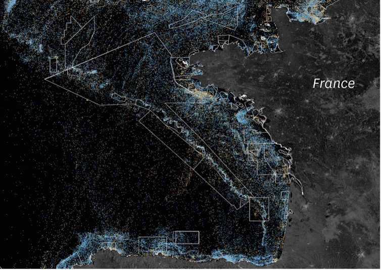
Example of industrial fishing vessels tracked by AIS (in blue) or not tracked (in beige) along the French Atlantic coast, based on data from the NGO Global Fishing Watch.
The boundaries of marine protected areas, according to the WDPA database, are shown in white. Satellite images from the Sentinel-1 program are used as the base map.
Raphael Seguin/University of Montpellier, Provided by the author
A 2024 study revealed that fishing catch per unit effort increases, on average, 12% to 18% near the boundaries of large fully protected MPAs.
“Illegal fishing takes place in areas of the ocean set aside for protection, but using satellites we have found — for the first time ever — that the level of protection determines how much risk industrial fishers are willing to take on,” Sala remarked.
“Illegal fishing takes place in areas of the ocean set aside for protection, but using satellites we have found — for the first time ever — that the level of protection determines how much risk industrial fishers are willing to take on,” Sala remarked.
“Fully and highly marine protected areas discourage illegal fishing. The stricter the rules in place to conserve ocean areas, the more benefits nations receive — including more fish to be caught outside protected areas’ boundaries.”
Links :
- Phys : Satellite imagery detects illegal fishing activity, shows strict protections work
- Science : Little-to-no industrial fishing occurs in fully and highly protected marine areas
- The Conversation : We tracked illegal fishing in marine protected areas – satellites and AI show most bans are respected, and could help enforce future ones
- Space : 'The ocean is no longer too big to watch': How AI and satellite data are helping rid Earth's seas of illegal fishing
- Oceanographic Mag : New AI study leaves "industrial fishing's bad guys nowhere to hide"
No comments:
Post a Comment