

The signal of a large number of ships appeared in a circle off Haifa harbor as a result of the jamming
Continuous on the Eastern Mediterranean GPS system
source : @theseainarabic
From Splash
The conflict between Israel and Iran stretched into a fourth consecutive day on Monday, rattling global energy markets and placing the maritime industry on edge.
The conflict between Israel and Iran stretched into a fourth consecutive day on Monday, rattling global energy markets and placing the maritime industry on edge.
While Israeli airstrikes have so far avoided directly targeting Iran’s crude oil infrastructure, a reported explosion at a natural gas plant near the massive South Pars field over the weekend has escalated concerns of broader regional destabilisation, while Iran has claimed it has successfully hit the Israeli port city of Haifa.

GPS jamming saw ships' AIS signals erroneously show them on land in Iran as they transited the Strait of Hormuz.
Source: Windward Maritime AI™ Platform
The spectre of a widening war in the oil-rich Middle East—which accounts for nearly a third of global crude flows—has driven energy prices and tanker freight rates sharply higher, as shipowners, traders, and insurers weigh the growing risks of operating in the region.
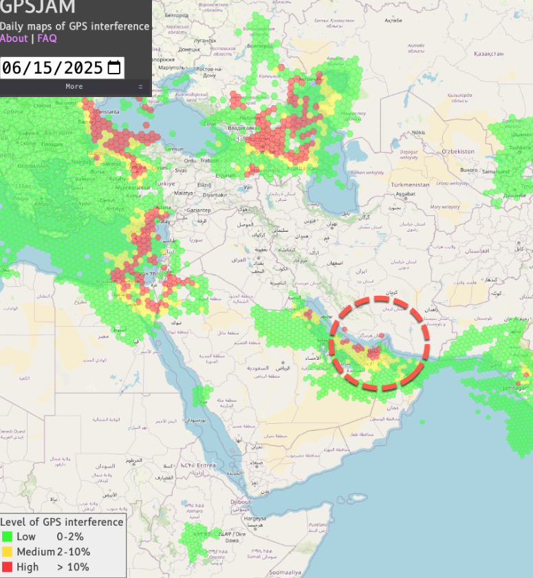
GPS Jamming Impacts Tankers Across Strait Of Hormuz
Bloomberg reports a surge in GPS jamming around the Strait of Hormuz, scrambling navigation for more than 900 vessels and hinting at a new form of disruption for the world's most critical maritime chokepoint.
Amid the intensifying conflict, maritime authorities have flagged significant electronic interference affecting commercial vessels across the Middle East.
The Joint Maritime Information Center (JMIC)—part of the US-led Combined Maritime Forces—confirmed Saturday that ships operating near the Persian Gulf and eastern Mediterranean have reported false positioning signals and severe GPS jamming.
A now-familiar circular spoofing pattern was observed off the coast of Haifa, a result of distorted GPS signals, according to data reviewed by commercial tracking platforms.
A now-familiar circular spoofing pattern was observed off the coast of Haifa, a result of distorted GPS signals, according to data reviewed by commercial tracking platforms.
The JMIC has urged ship operators to closely monitor navigation systems and prepare alternate communication and positioning methods to avoid incidents at sea.
Although Iran’s oil export terminals have not yet been hit, analysts remain focused on the potential for Iran to retaliate by disrupting traffic through the Strait of Hormuz—a vital artery through which about 20m barrels per day of crude and products transit.
While a full closure of Hormuz is seen as unlikely and logistically unsustainable, a partial disruption through harassment, seizure, or limited attacks on ships remains plausible.
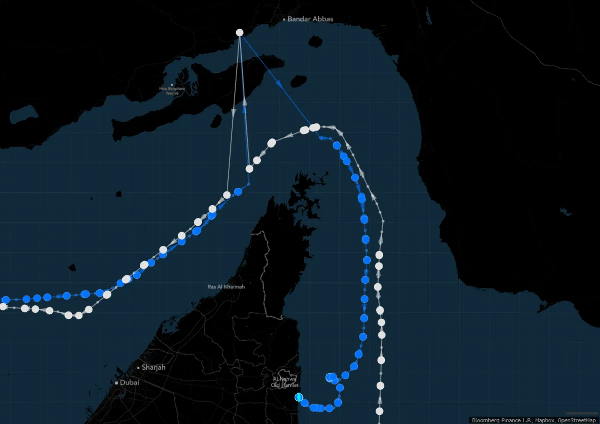
The Front Tyne (in white) and Elandra Willow (blue) were sailing through the Strait of Hormuz when they transmitted signals showing puzzling journeys near Iran’s Bandar Abbas.
Source: Bloomberg
Shipbroker Gibson warned that even minor disturbances could shrink the pool of shipowners willing to transit the strait, driving freight rates higher and potentially shifting demand to Atlantic Basin crude and other safer load zones.

There is growing concern that Iran may activate proxy forces to expand the conflict beyond the gulf. Maritime security analysts are warning that the Houthi rebels in Yemen, whose naval capabilities have been targeted by US strikes earlier this year, may resume attacks on Red Sea shipping in a show of support for Tehran.

The disruptions, which have affected various types of vessels, are believed to be caused by "extreme jamming" of signals from the Iranian port of Bandar Abbas.
Visualization of the Strait of Hormuz with the GeoGarage platform (NGA nautical raster chart)
UK-flagged vessels were issued warnings Friday against transiting the southern Red Sea.

Links :
- Safety4Sea : GPS jamming in the Middle East poses navigational challenge
- Marine Insight : Ships Report Sharp Rise In GPS Jamming After Israeli Airstrikes On Iran
- Bloomberg : Ships’ Signals Jammed as Israel-Iran Strikes Affect Persian Gulf
- CNBC : Over 900 ships lose GPS in Strait of Hormuz as Iran-Israel conflict disrupts signals
- GPSWorld : Leidos uses quantum technology to thwart GPS jamming
- Maitime Executive : Iranian Navy Leaves Bandar Abbas in a Hurry
- Windward : Escalating Conflict Hits Iranian Oil Exports: Windward-Detected Anomalies Reveal Increased Volatility
Windward : Middle East on the Precipice: GPS Jamming in the Arabian Gulf and Strait of Hormuz Disrupts 970 Ships Daily
ReplyDelete