
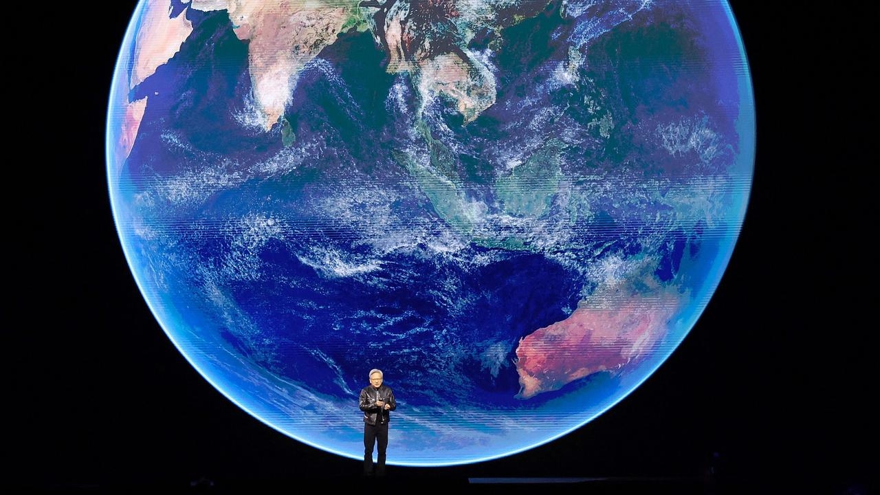
image credit : Nvidia
From Our World in Data by Hanah Ritchie
A four-day forecast today is as accurate as a one-day forecast 30 years ago.
Weather forecasts are often seen as just a nice thing to have.
Useful when planning a Sunday barbecue, or when we want to know if we’ll need an umbrella for the day.
But in many ways weather forecasts are absolutely crucial: they can be a matter of life and death.
Accurate forecasts can save lives by giving early warnings of storms, heat waves, and disasters.
Farmers use them for agricultural management, which can make the difference between a lost harvest or a harvest of plenty.
Grid operators rely on accurate forecasts of temperatures for heating and cooling demand, and how much energy they’ll get from wind and solar farms.
Pilots and sailors need them to carry people across oceans safely.
Accurate information about future weather is often absolutely vital.
NVidia Earth-2: A digital twin of the earth for predicting extreme weather using AI
In this article, I look at improvements over time and the global inequalities that need to be closed to protect lives and livelihoods around the world.

Weather forecasts have improved a lot
Weather forecasting has come a long way.
In 650 B.C.
the Babylonians would try to predict weather patterns based on cloud patterns and movements.
Three centuries later, Aristotle wrote Meteorologica, discussing how phenomena such as rain, hail, hurricanes, and lightning formed.
Much of it turned out to be wrong, but it represents one of the first attempts to explain how the weather works in detail.
It wasn’t until 1859 that the UK’s Meteorological Service (the Met Office) issued its first weather forecast for shipping.
Two years later, it broadcasted its first public weather forecast.
While meteorological measurements improved over time, the massive step-change in predictions came with the use of computerized numerical modeling.
This didn’t start until a century later, in the 1960s.
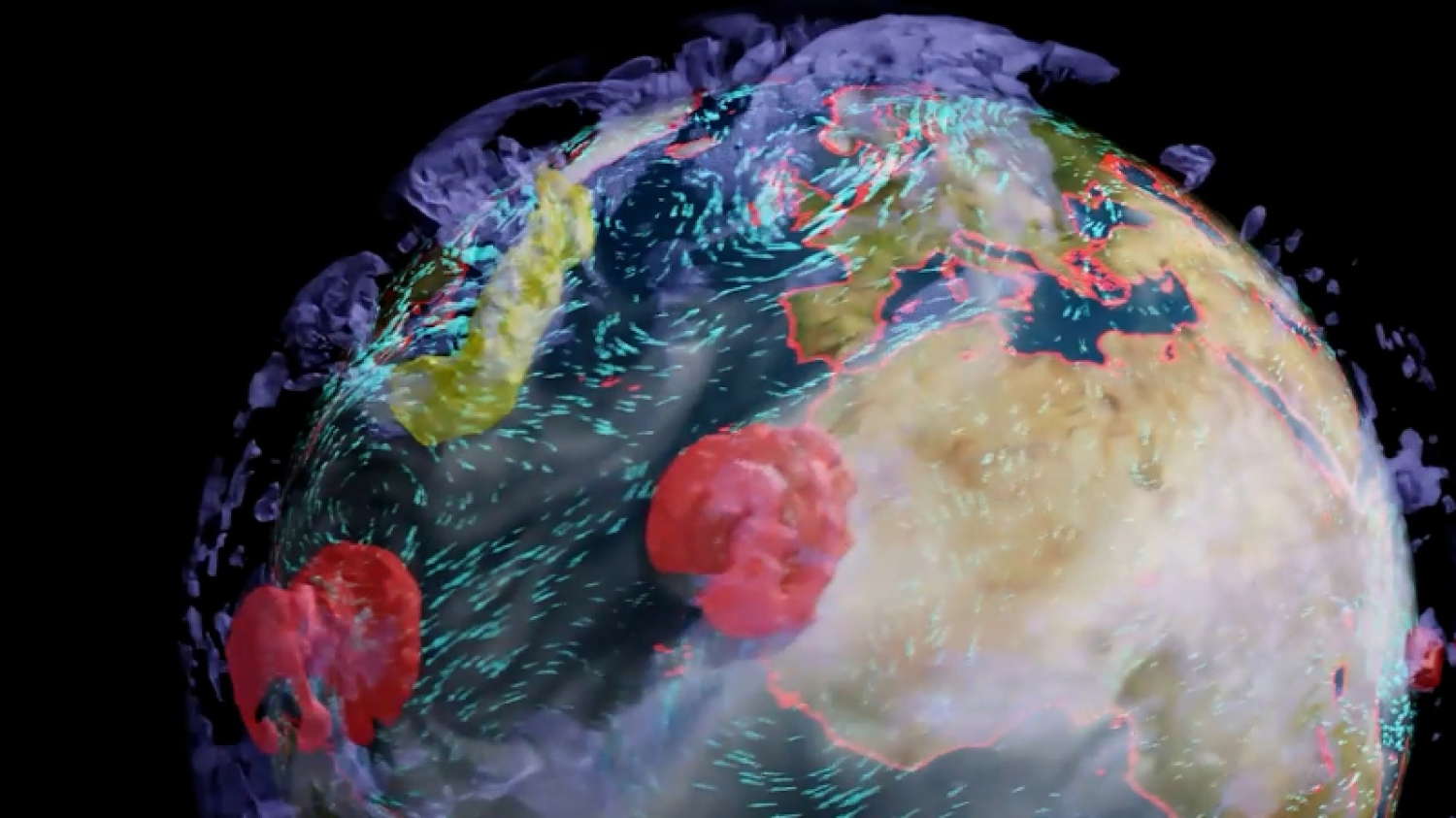
courtesy of NVidia Earth-2
Forecasts have improved a lot since then.
We can see this across a range of measurements, and different national meteorological organizations.
The Met Office says its four-day forecasts are now as accurate as its one-day forecasts were 30 years ago.
Predictions have gotten much better in the United States, too.
We can see this in some of the most important forecasts: the prediction of hurricanes.
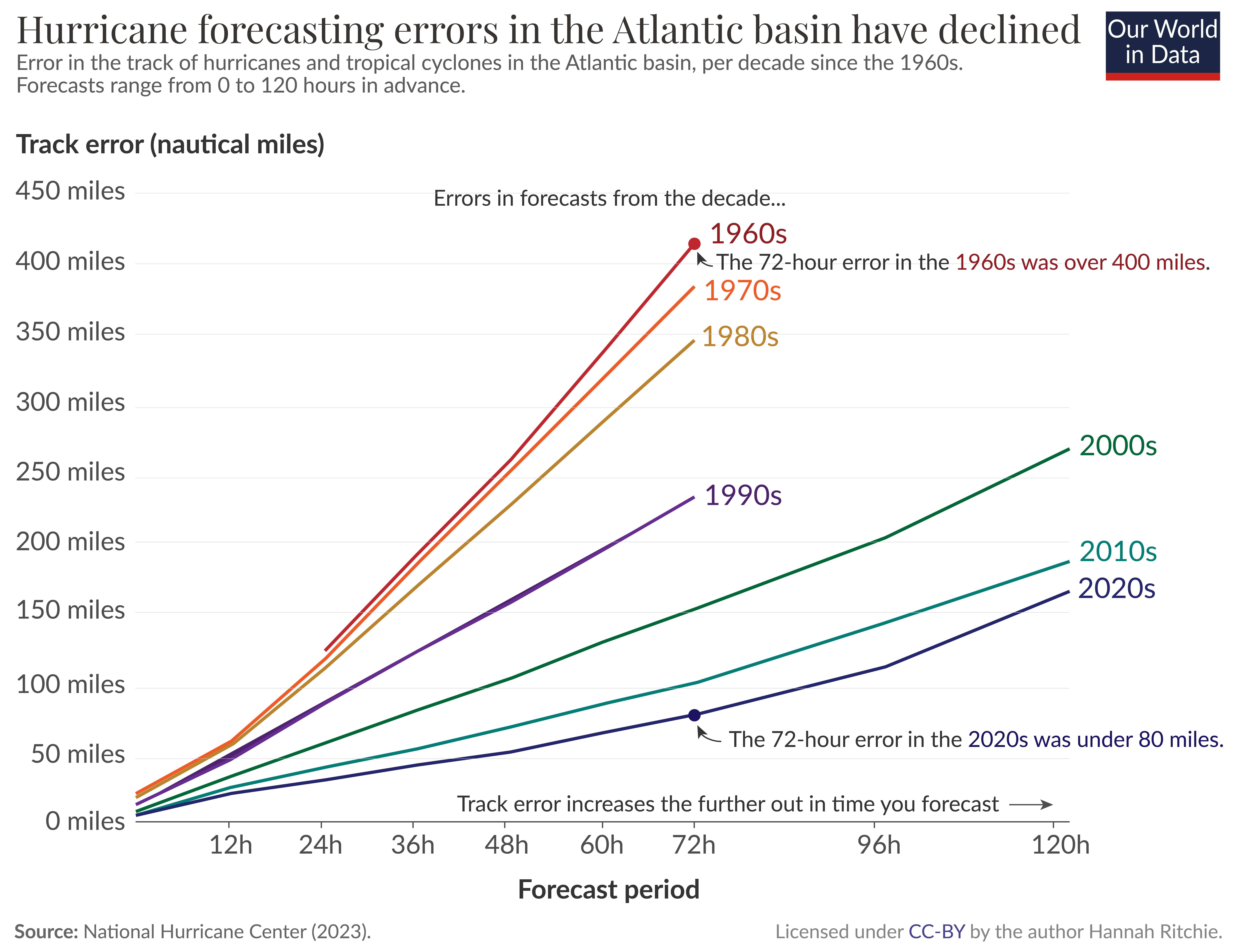
The National Hurricane Center publishes data on the “track error” of hurricanes and cyclones — the error in where the hurricane hits.
This is shown in the chart below, from the 1960s onwards.
Each line represents the error of forecasts for different time periods in advance.
For example, 12 hours before it hits, all the way up to 120 hours (or 5 days) before.
We can see that this track error — especially for longer-term forecasts — has decreased a lot over time.
In the 1970s, a 48-hour forecast had an error between 200 and 400 nautical miles; today this is around 50 nautical miles.

Average forecasting error of the track of hurricanes and tropical cyclones up to 120 hours in advance.
We can show the same data another way.
In the chart below, each line represents the average error for each decade.
On the horizontal axis we have the forecast period, again extending from 0 to 120 hours.
The 72-hour error in the 1960s and 70s was over 400 nautical miles.
Today, it’s less than 80 miles.
Meteorologists can now make pretty accurate predictions of where a hurricane will hit three or four days in advance, which lets cities and communities prepare while preventing unnecessary evacuations that might have been implemented in the past.
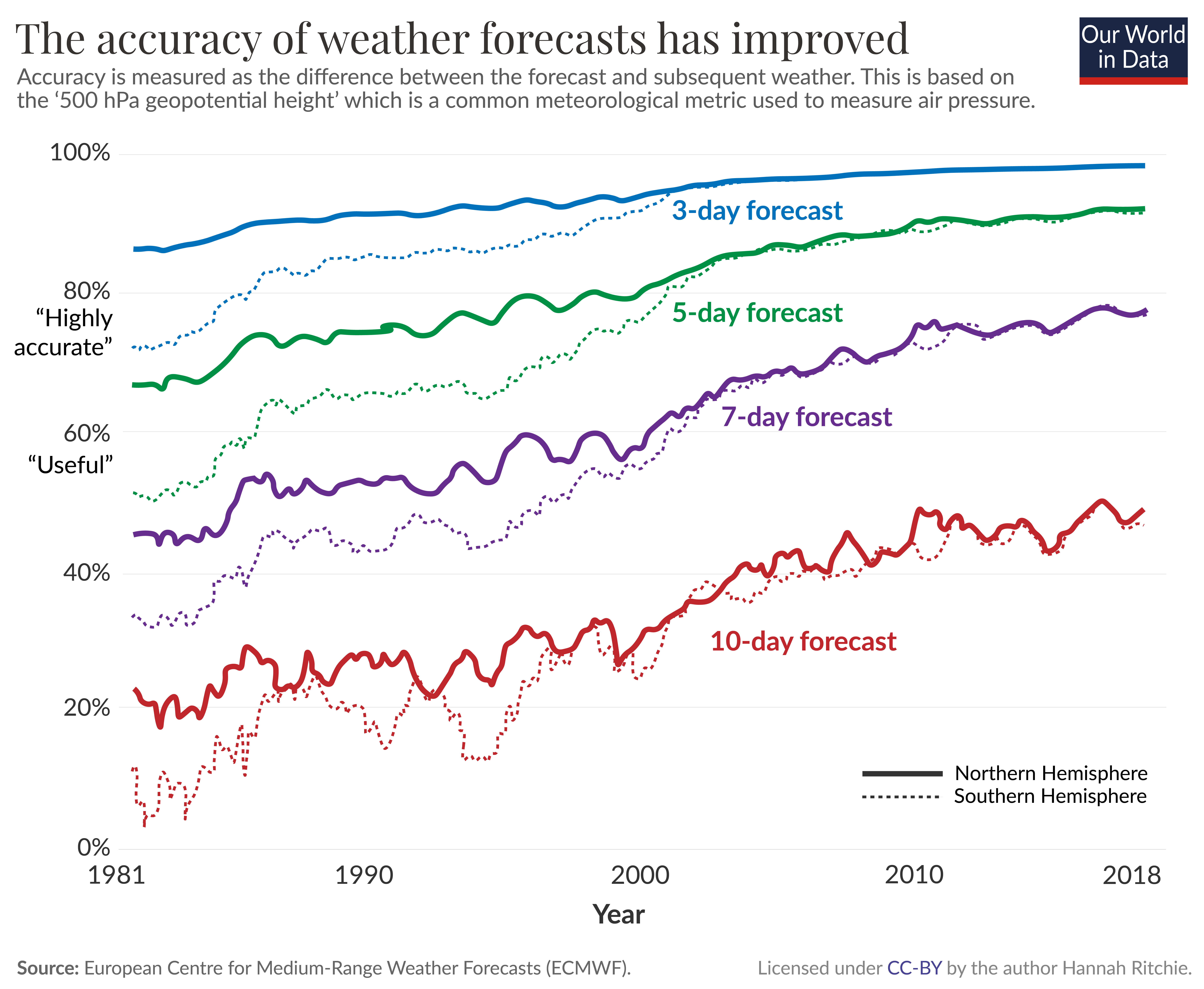
The European Centre for Medium-Range Weather Forecasts (ECMWF) produces global numerical weather models.
While national weather agencies use much higher-resolution processing to get local forecasts, these global models provide a crucial input into these systems.
The ECMWF publishes analyses of its errors over time.
This is shown in the chart below.1 It shows the difference between the forecast and the actual weather outcome for forecasts 3, 5, 7, and 10 days in advance.
The metric used here is the “500 hPa geopotential height”, a commonly used meteorological measure of air pressure (which dictates weather patterns).
The solid line is for the Northern Hemisphere, and the dashed line is for the Southern.
Three-day forecasts — shown in blue — have been pretty accurate since the 1980s, and have still gotten a lot better over time.
Today the accuracy is around 97%.
The biggest improvements we’ve seen are for longer timeframes.
By the early 2000s, 5-day forecasts were “highly accurate” and 7-day forecasts are reaching that threshold today.
10-day forecasts aren’t quite there yet but are getting better.
Why have weather forecasts improved?
A few key developments explain these improvements.2
The first big change is that the data has improved.
More extensive and higher-resolution observations can be used as inputs into the weather models.
This is because we have more and better satellite data, and because land-based stations are covering many more areas around the globe, and at a higher density.
The precision of these instruments has improved, too.
These observations are then fed into numerical prediction models to forecast the weather.
That brings us to the next two developments.
The computers on which these models are run have gotten much faster.
Faster speeds are crucial: the Met Office now chunks the world into grids of smaller and smaller squares.
While they once modeled the world in 90-kilometer-wide squares, they are now down to a grid of 1.5-kilometer squares.
That means many more calculations need to be run to get this high-resolution map.
The methods to turn the observations into model outputs have also improved.
We’ve gone from very simple visions of the world to methods that can capture the complexity of these systems in detail.
The final crucial factor is how these forecasts are communicated.
Not long ago, you could only get daily updates in the daily newspaper.
With the rise of radio and TV, you could get a few notices per day.
Now, we can get minute-by-minute updates online or on our smartphones.
Low-income countries have much worse forecasts, and often no early warning systems
At home in Scotland, I can open an app on my phone and get a pretty accurate 5-day forecast within seconds.
Unfortunately, this quality of information isn’t available to everyone.
There are large differences in weather forecasts across the world, with a large gap between rich and poor.
As the researchers Manuel Linsenmeier and Jeffrey Shrader report in a recent paper, a 7-day forecast in a rich country can be more accurate than a one-day forecast in some low-income ones.3
While national forecasts have improved over time across all income levels, the quality gap today is almost as wide as it was in the 1980s.
There are a few reasons for this.
First, far fewer land-based instruments and radiosondes measure meteorological data in poorer countries.
Second, the frequency of reporting is much lower.
This is unsurprising when we look at the amount of money spent on weather and climate information.
In a paper published in Science, Lucian Georgeson, Mark Maslin, and Martyn Poessinouw looked at differences in spending across income groups.4 This includes private and public spending on commercial products that fall within the definition of “weather and climate information services”.
This is shown as the spending per person, and the spending as a share of gross domestic product (GDP) in the chart below.
Low-income countries spend 15 to 20 times less per person than high-income countries.
But given the size of their economies, they actually spend more as a share of GDP.

This gap is a problem.
60% of workers in low-income countries are employed in agriculture, arguably the most weather-dependent sector.
Most are small-scale farmers, who are often extremely poor.
Having accurate weather forecasts can help farmers make better decisions.
They can get information on the best time to plant their crops.
They know in advance when irrigation will be most needed, or when fertilizers might be at risk of being washed away.
They can receive alerts about pest and disease outbreaks so they can either protect their crops when an attack is coming or save pesticides when the risk is low.
That means they can use precious resources most efficiently if they have access to accurate weather forecasts.
Good weather forecasts are most crucial for the poorest people in the world.
They’re also crucial for protecting against cyclones, heat waves, flooding, and storm surges.
Having accurate forecasts several days in advance allows cities and communities to prepare.
Housing can be protected, and emergency services can be on standby to help with the recovery.
But accurate forecasts alone don’t solve the problem: they’re only useful if they are disseminated to people so they can respond.
Many of the deadliest disasters over the last few decades were accurately forecasted ahead of time.
The common failure was poor communication.5
Improving forecasts is the foundation.
But these also need to be incorporated into effective early warning systems.
The World Meteorological Organization estimates that around one-third of the world — predominantly the poorest countries — do not have them.
Improving forecasts — especially in low-income countries — is underrated
After the big progress in recent decades, we take good weather forecasting and dissemination for granted in large parts of the world.
Making this available to everyone would make a difference.
This will be even more important as climate change increases the risks of weather-related disasters.
It is ultimately the poorest, who are the more vulnerable, who will suffer the worst consequences.
Better forecasts are key to good climate change adaptation.
Proper investment and financial support will be essential to close the gaps.
There also emerging technologies that could accelerate this.
A recent paper published in Nature documented a new artificial intelligence (AI) system — Pangu-Weather — that can perform forecasts as accurately (or better) than leading meteorological agencies up to 10,000 times faster.6 It was trained on 39 years of historical data.
The speed of these forecasts would make them much cheaper to run and could provide much better results for countries with limited budgets.
Faster and more efficient technologies can also fill the gaps where land-based weather stations aren’t available.
Sensor-carrying drones can run surveys over specific areas to build higher-resolution maps.
With lower-cost and more efficient ways of turning that into forecasts, mobile technologies can disseminate this information quickly.
Some companies are already sending messages to farmers in low-income countries to advise them on the best time to plant their crops.
This innovation is crucial to making countries more resilient to weather today.
But it’s also essential in a world where weather is likely to get more extreme.
Links :
- Forbes : 5 Mistakes People Still Make With Weather Forecasts
- TechRadar : Nvidia has virtually recreated the entire planet — and now it wants to use its digital twin to crack weather forecasting for good
- Axios : Nvidia powers up AI weather forecasting
- Investors : Spire Global Spikes On Nvidia Partnership For AI-Driven Weather Forecasts
- PRnewswire : The Weather Company Expands Collaboration with NVIDIA to Advance AI-based Weather Forecasting and Visualization Capabilities
- GeoGarage blog : Google DeepMind's AI weather forecaster handily beats a ... / AI breakthroughs could improve weather forecasts / The danger of leaving weatherprediction to AI / Why the weather forecast will always be a bit wrong / The weather machine reveals how the forecast is made— ... / How forecast models can lead to bad forecasts / The Weather Service prepares to launch prediction model ... / Was the forecast for hurricane Ian bad? Depends on your ... / Comparing forecast models for Irma / New model based on Artificial Intelligence available in ...
InfoPlaza : AI and weather forecasting: NWP vs MLWP models
ReplyDelete