Hy-Brasil is also known as the Irish Atlantis (Source: YouTube)
From History of Yesterday by Irena Curik
On maps, phantom island lies somewhere in the Atlantic Ocean to the west of Ireland
Irish folktales are full of ghosts, giants, pookas, demons, goblins, banshees, fairies, witches, widows, old maids, and other imaginary beings and places.
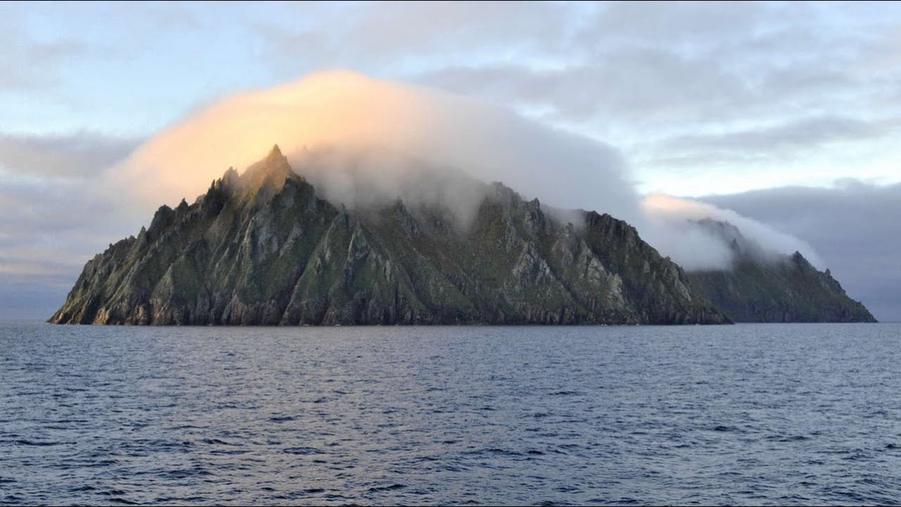
One such impossible place is a strange, eerie island on the west coast of Ireland, shrouded in thick fog and seen only once every seven years.
In the oral storytelling tradition of Ireland, the island was described as an island in a fog bank or a “floating island” that disappeared when approached.
Later, these stories appeared in printed books of Irish folklore, and you do not know which one to read first because they are all mind-blowing.
According to the 1888 book Irish Wonders by D. R. McAnally, the floating island was seen by the inhabitants of County Cork on 7 July 1878.
The number seven has already appeared three times, and this is very symbolic because seven is considered a spiritual number that indicates a strong spiritual presence behind the matter.
It can also indicate coded information, as in alchemical texts.
In any case, the strange apparition was described in Irish Wonders as follows:
“On Sunday afternoon, 7 July 1878, the inhabitants of Ballycotton in County Cork were greatly excited by the sudden appearance of an island far out to sea, which was not known to exist.
The men of Ballycotton town and island were fishermen and knew the sea as well as they knew the land.
The day before they had gone out in their boats and headed for the spot where the strange island now appeared, and they were sure it was the best fishing ground they had.
And still, they looked further, and still, their astonishment grew, for the day was clear, and the island was as plain to see as the hills to the north.
In some places it was rugged, in others thickly wooded; here and there deep shadows on the sides pointed to ravines thick with brush and grasses.
At one end it rose almost steeply from the sea, at the other it fell gradually; the dense forest of the mountainous part gave way to smaller trees, these in turn to shrubs, these in turn to green meadows, which finally merged with the sea and could no longer be distinguished from the waves.”
The island appeared on maps until at least 1873
Hy-Brasil has been featured in all sorts of legends, including giant black rabbits who lived with a sorcerer, gods hidden in the mist, lost civilizations, and, of course, UFOs.
Although it was never discovered, the phantom island was on maps from the 14th to the 19th century.
Historians believe that this is because cartographers could not check all places and locations and therefore sometimes inadvertently included persistent rumors in their maps.
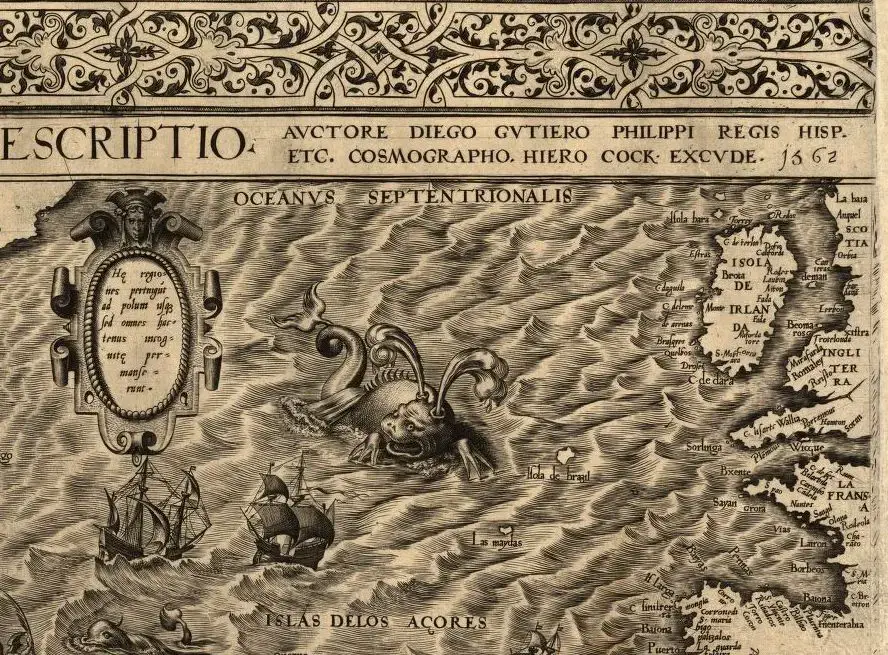
A section of a map by the Spanish cartographer Diego Gutiérrez from 1562 shows the island of Isola de Brazil, which lies southwest of Ireland and east of the sea monster
(Source: Rare maps)
An island called Bracile was first marked on a portolan chart in 1325 by the Mallorcan cartographer Angelino Dulcert.
The Venetian cartographer Andrea Bianco entered an island called Insula de Brasil on a map in 1436.
He assigned it to a group of islands in the Atlantic, and for a time the Insula de Brasil was identified with the present-day Azores island of Terceira, on which there is a volcanic mountain that is still called Monte Brasil.
On a Catalan map of 1480, there are even two islands named “Illa de brasil”, one southwest of Ireland and one south of “Illa verde” or Greenland.
The Spanish cartographer Diego Gutiérrez included Isola de Brasil in his map of 1562.
A map by Flemish cartographer Abraham Ortelius from 1570 shows an island called Brasil west of central Ireland.
A 1630 nautical chart by Portuguese cartographer João Teixeira Albernaz features the island in a circular shape divided in half by a river and called Do brasil.
A map by the British cartographer Thomas Jefferysfrom 1753 shows the island southwest of Ireland and calls it the “Imaginary Isle of O Brazil”, proving that cartographers had begun to doubt the island’s existence.
And on the map of the French cartographer Guillaume de L’Isle of 1769, the island is just a rock called Rocher de Brasil (Brasil Rock).
Brasil Island continued to appear on maps until 1873 when it was last shown on a British Admiralty chart.
Hy-Brasil has nothing to do with Brazil or reality
The origin of the names Brasil and Hy-Brasil is unknown, but in Irish tradition, they are thought to derive from the Irish Uí Breasail (“descendants (of Bresail”), one of the ancient clans in the north-east of Ireland: Í: island; bres: beauty, worth, great, powerful.
The island has changed many names, from Brasil, Brazil, Breasil, Hy-Brasil to O’Brasil.
There have been many documented expeditions to the island which, apart from their fanciful descriptions, haven’t resulted in any finds.
In 1480 and 1481, two explorers set out from Bristol to spend more than two months sailing around the Irish coast to find the mysterious island.
Although both expeditions were supposedly unsuccessful, there is a report from a Spanish diplomat in 1497 who recalls “the men from Bristol who found Brasil“.
Another account from 1629 by a French adventurer, M. de La Boullaye Le Gouz, tells how several sailors discovered the Hy Brasil.
He also mentions a letter written by a Derry man to a friend in England, describing how Captain John Nisbet and his crew were stranded on Hy-Brasil and found an old empty castle.
After they’d gone to sleep during the night, they suddenly woke up and “saw a very old, serious gentleman and ten men following him, coming bare-chested (as if they were his servants) to the shore where the ship lay“.
The mysterious gentleman gave a welcome party at which he revealed his identity.
He said the island was called O’Brasile and his ancestors had been princes, but then a great evil sorcerer had wiped them all out, leaving only a few members of the family alive behind the unbreakable castle, while he’d made the island invisible so that no one could find it.
When the captain knocked yesterday, he released the spell and the island will be visible again.
The gentleman has also distributed great gifts to the crew, who’ve happily returned home, but the island has still not become visible.
What about UFOs?
This is a strange story.
42 years ago, in late December 1980, a famous UFO encounter occurred in Rendlesham Forest, Suffolk, England, near a military base.
One of the witnesses, Sergeant Jim Penniston, said that when he touched the alien craft, information was telepathically implanted in his brain.
The next day he wrote down the information in his notebook.
It was a 16-page list with a binary code that seemed indecipherable.
Decades later, however, the code was run through sophisticated computer software and decoded as a list of very specific information matched to specific locations on Earth.
One location was the pyramids of Giza.
Another was the Nazca Lines in Peru.
And one was exactly where the ancient cartographers located Hy-Brasil!
Is this a coincidence or proof that both aliens and Hy-Brasil exist?
Links :
- GeoGarage blog : Hy-Brasil, the other Atlantis / These imaginary islands only existed on maps / 'The Phantom Atlas' book review: paps with gaps / Ancient maps show islands that don't really exist /the story of Islands that have vanished from nautical charts / Mystery of the phantom islands solved: Lands that ...
No comments:
Post a Comment