The Phantom Atlas is an atlas of the world not as it ever existed, but as it was thought to be.
These marvellous and mysterious phantoms - non-existent islands, invented mountain ranges, mythical civilisations and other fictitious geography - were all at various times presented as facts on maps and atlases.
This book is a collection of striking antique maps that display the most erroneous cartography, with each illustration accompanied by the story behind it.
Exploration, map-making and mythology are all brought together to create a colourful tapestry of monsters, heroes and volcanoes; swindlers, mirages and murderers.
Exploration, map-making and mythology are all brought together to create a colourful tapestry of monsters, heroes and volcanoes; swindlers, mirages and murderers.
Sometimes the stories are almost impossible to believe, and remarkably, some of the errors were still on display in maps published in the 21st century.
Throughout much of the 19th century more than 40 different mapmakers included the Mountains of Kong, a huge range of peaks stretching across the entire continent of Africa, in their maps - but it was only in 1889 when Louis Gustave Binger revealed the whole thing to be a fake.
For centuries, explorers who headed to Patagonia returned with tales of the giants they had met who lived there, some nine feet tall.
Then there was Gregor MacGregor, a Scottish explorer who returned to London to sell shares in a land he had discovered in South America.
He had been appointed the Cazique of Poyais, and bestowed with many honours by the local king of this unspoiled paradise.
Now he was offering others the chance to join him and make their fortune there, too - once they had paid him a bargain fee for their passage...
From WSJ by A. Roger Ekirch
Islands that never existed inspired adventurers to undertake quixotic trips with tragic consequences.
In the spirit of modern treasure hunters in quest of lost shipwrecks, early explorers scoured the seas for islands and continents born of legend, delusion and deception.
Maps and navigation charts afforded their only guidance, and many are colorfully reproduced in Edward Brooke-Hitching’s “The Phantom Atlas: The Greatest Myths, Lies and Blunders on Maps.” The author details over 50 instances of fake cartography, including their reputed coordinates: from the Strait of Anian to the Phantom Lands of Zeno.

Athanasius Kircher's map of Atlantis, placing it in the middle of the Atlantic Ocean, from Mundus Subterraneus 1669, published in Amsterdam.
The map is oriented with south at the top.
As Mr. Brooke-Hitching describes, honest mistakes, grounded in religious dogma and classical mythology, were often to blame for inaccuracies.
(Plato was among the first to record the myth of the Island of Atlantis, whose destruction, he wrote, had left a “shoal of mud” that rendered the sea “impassable and impenetrable.”)
But navigators were also fooled by optical illusions arising from mirages, icebergs and low-lying clouds dubbed “Dutch Capes.”
In the meantime the persistence of fictitious claims led innumerable generations of mariners astray.
Remarkably, not until 2012, after first being “sighted” by a whaling ship in the late 1800s, was Sandy Island in the Coral Sea “undiscovered” by an Australian team of marine scientists.
In time, with the proliferation of printing in the 1500s, the publication of salacious tales turned a ready profit.
Besides gold, silver and precious gems, far-off lands were said to contain all manner of forbidding creatures—demons, Patagonian giants and human-shaped fruit.
As Jonathan Swift mocked: “So geographers in Afric-maps / With savage-pictures fill their gaps.” Few scribes were as infamous as the 18th-century French impostor, George Psalmanazar, who claimed to be a native of the primitive island of Formosa, brought against his will to Europe by a Jesuit priest.
Years after the appearance in 1704 of his adventures, a spurious publication featuring no shortage of gruesome tales, he remained a celebrity.
When asked why he had befriended the scoundrel, Samuel Johnson avowed, “I should as soon have thought of contradicting a bishop.”
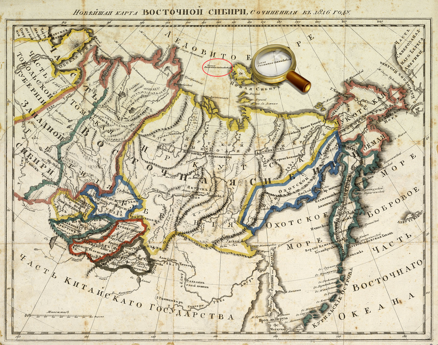
Sannikov Land is a phantom island in the Arctic Ocean,
which was allegedly seen by some researchers to the north of the New Siberian Islands.
Sannikov Island, “discovered” around 1810 in the Arctic Ocean by a Russian geographer, spurred later expeditions, all in vain, before being omitted from maps beginning in 1937.
Possibly it had sunk, a common calamity for shoals saturated by permafrost in northern latitudes.

Also known as Maida or the Isle of Mam, Mayda is a phantom island in the Atlantic Ocean located southwest of Ireland.
Sailors in the Age of Exploration considered Mayda very unsafe — a 1397 map showed it surrounded by dragons and sea monsters, and it included a warning in Latin about the dangers waiting for anyone who sailed too close.
The mysterious island first showed up on maps in the Middle Ages and continued to appear throughout the centuries, always as a crescent-shaped island.
Its final appearance was on a 1906 map published by Rand McNally, a surprisingly recent appearance considering there’s nothing to be found to the southwest of Ireland.
No less baffling was the fate of Mayda, an island in the North Atlantic that cartographers officially expunged after it had appeared on maps for more than five centuries.
Yet in 1948, in the reputed vicinity of Mayda, where ocean depths reached 2,400 fathoms, the captain of a freighter noticed a seeming change in the sea’s color and took a sonar reading that revealed a depth of only 20 fathoms and a submerged land mass 28 miles in diameter—the victim, speculates Mr.
Brooke-Hitching, of “some act of geologic violence centuries ago.”

The
Phantom Atlas is a beautifully produced volume, packed with stunning
maps and drawings of places and people that never existed.
The
remarkable stories behind them all are brilliantly told by Edward
Brooke-Hitching in a book that will appeal to cartophiles everywhere.
It would be wrong to dismiss “The Phantom Atlas” as an exotic side-show.
Cartographic errors sowed real anxiety and confusion among mariners.
They influenced shipping routes and inspired adventurers to undertake quixotic expeditions, occasionally with tragic consequences.
“These phantoms,” the author tartly observes, “were considered a plague on navigational charts.”

Old map showing the Mexican phantom island Bermeja.
Tanner, Henry S. - A Map of the United States of Mexico, 3rd ed.
Tanner, Henry S. - A Map of the United States of Mexico, 3rd ed.
And there have been geopolitical reverberations.
Just nine years ago, in the Gulf of Mexico, a controversy was finally resolved over the reputed island of Bermeja, a Mexican possession originally recorded in 1539 on a Spanish map.
Locating the tiny island promised to dramatically extend Mexico’s nautical sovereignty to include precious oil rights in the Gulf.
Despite a last-ditch effort, neither aircraft nor a Mexican research vessel succeeded in finding Bermeja.
Diehard believers, ceding no ground, cited global warming or the possibility of an undersea earthquake—thin satisfaction at best.
Because billions of barrels of oil were at stake, the CIA was also blamed for the island’s destruction.
“The Phantom Atlas” will prove rewarding for armchair adventurers and nautical historians.
For more intrepid souls, it affords an indispensable guide to legendary sites or, just possibly, remote realms waiting to be reclaimed.
Don’t forget to bring a camera.
Links :
- Mythical islands
- GeoGarage blog : Ancient maps show islands that don't really exist / These imaginary islands only existed on maps / Mystery of the phantom islands solved: Lands that ... / South Pacific Sandy Island 'proven not to exist' / Hy-Brasil, the other Atlantis / About the Null island at 0°0'0" N 0°0'0" E / Lost Islands: the story of Islands that have vanished ...
YouTube : How bold errors on old world maps shaped the 21st century
ReplyDelete