
High-res 3D images of the GBR bioherms
North-westerly view of the Bligh Reef area off Cape York.
Depths are coloured red (shallow) to blue (deep), over a depth range of about 50 metres.
Bathymetry data : Australian Hydrographic Service.

Blight reef with the GeoGarage platform (AHS chart)
James Cook University, University of Sydney and Queensland University of Technology scientists working with laser data from the Royal Australian Navy have discovered a vast reef behind the familiar Great Barrier Reef.
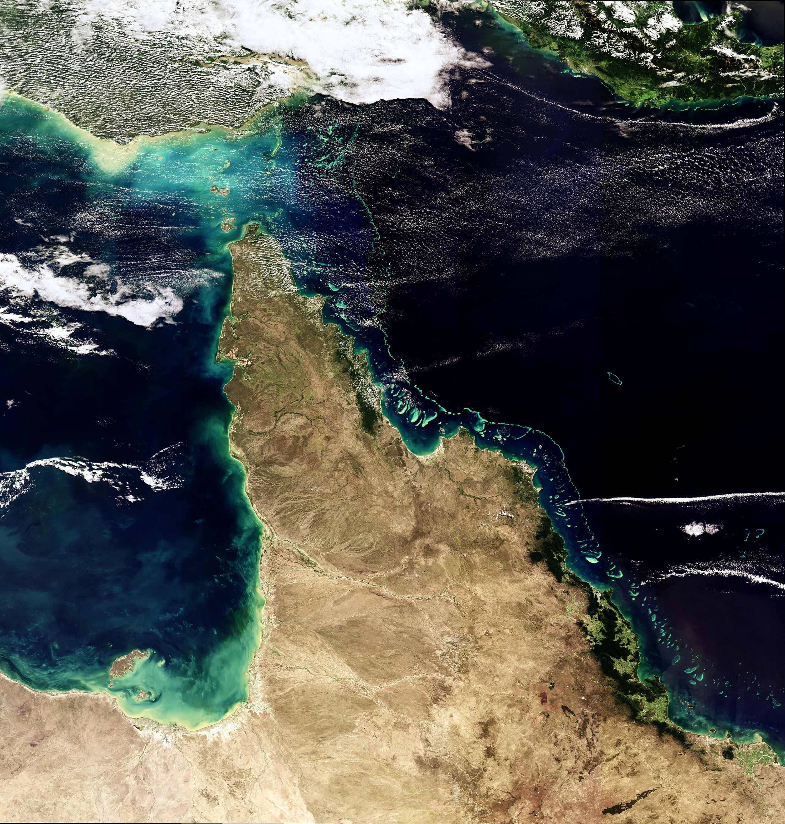
The Great Barrier Reef, Australia
This Envisat image features one of the natural wonders of the world – the Great Barrier Reef in the Coral Sea off the east coast of Queensland, Australia.
Australian researchers have discovered that Envisat's Medium Resolution Imaging Spectrometer (MERIS) sensor can detect coral bleaching down to 10 m deep.
This means Envisat could potentially map coral bleaching on a global scale.
MERIS acquired this image on 18 May 2008, working in Full Resolution mode to yield a spatial resolution of 300 m.
“We’ve known about these geological structures in the northern Great Barrier Reef since the 1970s and 80s, but never before has the true nature of their shape, size and vast scale been revealed,” he said.
Dr. Beaman said it was an astounding revelation.
“The deeper seafloor behind the familiar coral reefs amazed us.”

North-westerly view of the Ribbon Reef No. 10 area off Cooktown.
Depths are coloured red (shallow) to blue (deep), over a depth range of about 50 metres.
courtesy of deepreef.org

Ribbon Reef No. 10 with the GeoGarage platform (AHS chart)
- Laser Airborne Depth Sounder (LADS) uses red and green LiDAR technology to rapidly scan the seafloor to depths of about 50 meters, generating a dense grid of depth data points. The bathymetry data are then used by the Australian Hydrographic Service (AHS) to revise the nautical charts used by mariners.
- The Weapons Research Establishment first developed LADS airborne LiDAR bathymetry in Australia in 1972. The navy LADS Flight unit is based out of Cairns for year-round surveying of Australia’s shallow waters.
- Marine geologists previously understood the bioherms to form linear, dune-like parallel ridges and troughs, quite different to the complex seafloor now revealed with the benefit of LiDAR and multibeam swath bathymetry data collected in the past few years.
- Less than 15% of the Earth’s oceans deeper than about 200 metres have been mapped using modern surveying techniques.
Multibeam sonar flythrough of the submarine canyons along the GBR margin.
These canyons drop over 2000 metres from the continental shelf into adjacent basin.
These form small limestone flakes on death, looking much like white cornflakes.
Over time these flakes build up into large reef-like mounds, or bioherms.
Mardi McNeil from Queensland University of Technology and lead author on the new research paper, said their extent is vast.
“We’ve now mapped over 6000 square kilometers. That’s three times the previously estimated size, spanning from the Torres Strait to just north of Port Douglas. They clearly form a significant inter-reef habitat which covers an area greater than the adjacent coral reefs.”
Associate Professor Jody Webster from the University of Sydney, said the revelations about the extent of the bioherm field make questions over its vulnerability to climate change even more pressing.
“As a calcifying organism, Halimeda may be susceptible to ocean acidification and warming. Have the Halimeda bioherms been impacted, and if so to what extent?”
Lidar mapping over shallow coral reefs from the northern Great Barrier Reef (2009)
The movie shows the operator of the Laser Airborne Depth Sounder (LADS) system and the aircraft shadow while flying at 1200 feet and scanning a laser beam at the seabed.
The mapping technique results in dense depth data to about 60 metres depth.
Dr. Beaman said the discovery also opened up many other new avenues of research.
“For instance, what do the 10-20 meter thick sediments of the bioherms tell us about past climate and environmental change on the Great Barrier Reef over this 10,000 year time-scale? And, what is the finer-scale pattern of modern marine life found within and around the bioherms now that we understand their true shape?”
He said future research would require sediment coring, sub-surface geophysical surveys, and employing autonomous underwater vehicle technologies to unravel the physical, chemical and biological processes of the structures.
Links :
Forbes : 3D Map Of Ocean Floor Uncovers Strange Surprise
ReplyDelete