Saturday, August 2, 2025

The Western Indian Ocean maritime emergency contact map

download map in pdf
 
This reference tool consolidates the complex network of maritime stakeholders across the region for the first time:

• Regional Maritime Coordination Centers
• Naval Operations Centers
• Emergency Response Services
• Maritime Security Organizations
• National Maritime Authorities across the Western Indian Ocean Region

Friday, August 1, 2025

Iranian researchers elevate maritime navigation with advanced antenna design


From MaritimeTechnologyReview by Theo Clark

In a significant stride for satellite communication technology, researchers have developed a novel antenna design that promises to enhance navigation and data acquisition in challenging environments, including the maritime sector.
The study, led by Aliakbar Dastranj from the Electrical Engineering Department at Yasouj University in Iran, introduces a dual-sense circularly polarized (CP) crossed-dipole array antenna tailored for Global Navigation Satellite System (GNSS) frequency bands.
Published in the IEEE Access journal, the research presents a solution that could revolutionize precision navigation and data collection in urban, forested, and maritime settings.

So, what does this mean in plain terms?
Imagine you’re out at sea, trying to get a reliable GPS signal.
The new antenna design is like having a super-powered receiver that can pick up signals more clearly, even when there are obstacles like tall buildings, dense forests, or even the ship’s own structure causing interference.
This is achieved through a clever design that uses a single pair of dual-band linearly polarized dipole antennas (LPDAs) and an optimized double-branch line coupler (ODBLC).
The result?
A compact, cost-effective antenna that can handle both right-hand and left-hand circular polarization, significantly reducing multipath interference.

The antenna’s impressive specifications include impedance bandwidths of 44.83% for right-hand circular polarization (RHCP) and 46.30% for left-hand circular polarization (LHCP), with axial ratio bandwidths of 47.69% and 44.78%, respectively.
This translates to a broader range of frequencies the antenna can effectively operate within.
The peak gains of 7.08–7.10 dBic ensure strong signal reception, all packed into a compact form factor of 160×160×44.6 mm³.
As Dastranj explains, “The simplified feed architecture enhances manufacturability and reduces fabrication costs,” making this technology not just advanced but also practical for widespread use.

For the maritime industry, the implications are substantial.
Precision navigation is crucial for safe and efficient shipping, especially in congested or challenging environments.
Autonomous vehicles, including unmanned ships and underwater drones, rely heavily on accurate positioning data.
This new antenna design could significantly improve the reliability of GNSS signals, enhancing the performance of these technologies.
Additionally, geodetic surveying and meteorological data acquisition, both vital for maritime operations, stand to benefit from the improved signal quality and reduced multipath interference.

The commercial opportunities are equally compelling.
The simplified design and reduced fabrication costs mean that this technology could be integrated into a wide range of maritime applications without breaking the bank.
From commercial shipping to offshore oil rigs, the potential for enhanced navigation and data collection is vast.
As the maritime industry continues to embrace digital transformation, technologies like this dual-sense circularly polarized antenna could play a pivotal role in shaping the future of sea travel and operations.

In summary, the research led by Aliakbar Dastranj and published in the IEEE Access journal offers a promising advancement in antenna technology.
By improving signal reception and reducing interference, this innovation could significantly impact the maritime sector, enhancing navigation, data collection, and overall operational efficiency.
As the technology becomes more widely adopted, it has the potential to transform how we navigate and interact with the world’s oceans.

Thursday, July 31, 2025

'Ghost island' appears after underwater eruption, then vanishes into the Caspian Sea — Earth from space

 
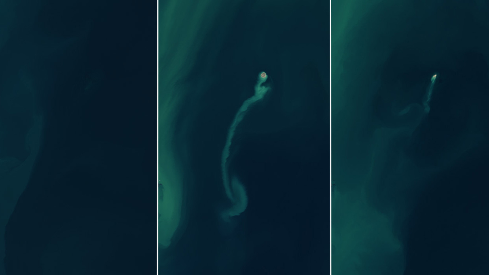
A temporary land mass appeared above an underwater mud volcano off the coast of Azerbaijan in January 2023.
By the end of 2024, it had almost completely disappeared.
(Image credit: NASA/USGS/Landsat/Wanmei Liang)

From LiveSciences by Harry Baker 

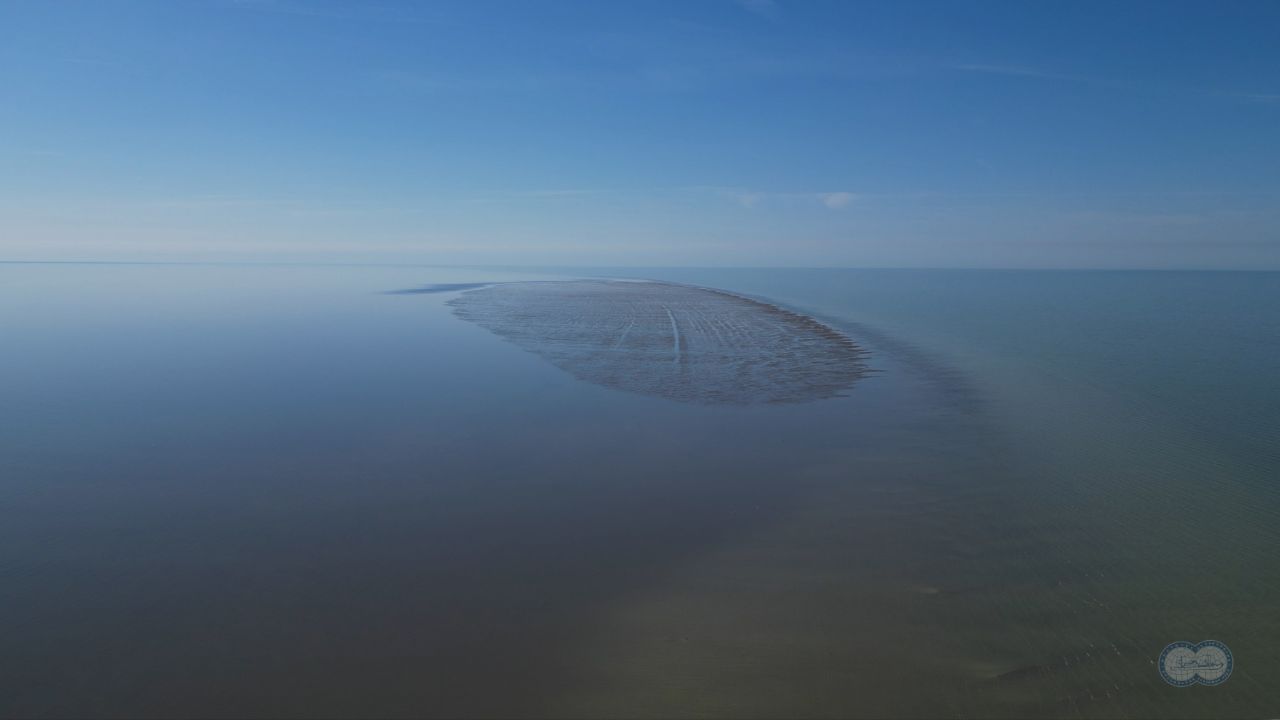
A series of photos taken between 2022 and 2024 shows the emergence and rapid disappearance of a volcanic "ghost island" off the coast of Azerbaijan. 

A striking series of satellite photos shows the brief lifespan of a "ghost island" that emerged and quickly disappeared in the Caspian Sea after an underwater mud volcano blew its top.

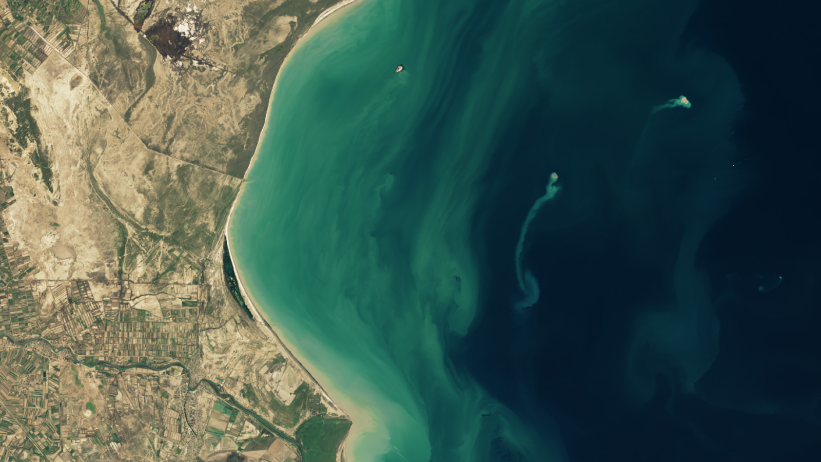
The fleeting landmass emerged at the end of January 2023 above Kumani Bank, an underwater volcano about 15 miles (24 kilometers) off the east coast of Azerbaijan.
 

By the time it was fully formed, on Feb. 4, the island measured around 1,300 feet (400 meters) across, according to NASA's Earth Observatory.

However, the island was unstable, and by the time the last photo was taken in December 2024, it had "nearly eroded away, retreating from view like an apparition," Earth Observatory representatives wrote. By now, the island has likely vanished.
 
Kumani Bank has erupted eight times since it was first discovered in 1861.
Each outburst lasted just a few days, yet all of these events resulted in at least some form of temporary island.
The strongest recorded eruption, which occurred in 1950, resulted in a 2,300-foot-wide (700 m) landmass that stood 20 feet (6 m) above sea level.

Azerbaijan is home to more than 300 mud volcanoes, including dozens that are hidden beneath the waves of the Caspian Sea. 
(Image credit: NASA/USGS/Landsat/Wanmei Liang)

Kumani Bank is a mud volcano, meaning it spews a superheated slurry of mud and water instead of lava and ash.

Azerbaijan has one of the highest concentrations of mud volcanoes anywhere on Earth, with more than 300 muddy vents on the mainland or offshore.
This is due to the country's position above a "convergence zone" where the Arabian and Eurasian tectonic plates collide, leading to increased geothermal activity.

Mud volcanoes are not as violent or destructive as other volcanoes.
However, they do contain high levels of pressurized natural gas.
This gas can be ignited by sparks from colliding rocks, leading to sporadic fiery outbursts.

An underwater mud volcano near Kumani Bank is believed to have triggered a towering inferno, several hundred feet tall, that exploded above the Caspian Sea in 2021.
 
Other volcanic "ghosts"

Normal, non-mud volcanoes can also create temporary islands when they erupt beneath the waves.

In 2015, a 0.7-square-mile (1.9 square kilometers) island emerged in the southern Pacific Ocean above the Hunga Tonga-Hunga Ha'apai volcano in Tonga.
However, it was wiped out by the same volcano in January 2022, when the underwater mountain unleashed one of the most powerful volcanic eruptions ever recorded.

Researchers later revealed that the colossal explosion likely killed never-before-seen microbe species that evolved on the isolated landmass.

In October 2023, a violent eruption off the coast of Japan's Iwo Jima island also created a temporary landmass, dubbed Niijima, or "New Island." 
It grew to be around 330 feet (100 m) wide and 66 feet (20 m) tall, and was clearly visible from space.

But in March 2024, drone footage revealed that the island had started to quickly sink into the sea, despite continued signs of volcanic activity, according to Newsweek.
 
Links :

Wednesday, July 30, 2025

Trump order puts deep sea mining on path to commercialization

Small polymetallic nodules after extraction from the seabed (TMC)

From Maritime Executive

On Thursday, President Donald Trump signed a much-anticipated executive order that will set up an American permitting process for deep sea mining in international waters, beyond the U.S. outer continental shelf.

The order directs the Commerce Department to expedite a sovereign permitting process for mining under the Deep Seabed Hard Mineral Resources Act, an obscure statute from the 1980s.
The Cold War-era law provides a pathway to unilateral resource recovery on the high seas, bypassing the UN's International Seabed Authority (ISA), which has jurisdiction under UNCLOS.

The richest areas for polymetallic nodules - the only technologically mature mining target - are far outside of U.S. Outer Continental Shelf, primarily in the Pacific between Hawaii and Mexico.
The nodules in the Clarion Clipperton Zone contain roughly 28 percent manganese; 1.3 percent nickel; 1.1 percent copper; and 0.2 percent cobalt, all strategically valuable elements.
The nodules also contain trace amounts of rare earth metals, which are critically important to defense production.

Canadian mining firm The Metals Company has a years-long interest in this region, and it worked closely with the White House in the months leading up to the announcement.
It is the only Western firm with equipment capable of performing the work in the immediate term, and is expected to apply for a U.S. mining permit, with support from Swiss contractor Allseas and Korean-built drillship Hidden Gem.The Metals Company's stock soared at 1100 hours Thursday, and was up 44 percent at closing.

ISA has taken a cautious approach to licensing, and is weighing the economic benefits against scientists' warnings of large-scale and long-lasting environmental damage.
However, the U.S. is not a signatory to UNCLOS, and the Trump administration is motivated to move quickly to "restore American dominance in offshore critical minerals and resources."

More than three dozen nations, including China, Russia, the UK, France and India, have already condemned the U.S. license plan and registered their support for the ISA. 
The ISA's secretary-general, Leticia Carvalho, implied in a statement that the order was inconsistent with UNCLOS. 
“The International Seabed Authority remains the sole body with the legal mandate to regulate activities in the area, and its legitimacy stems directly from international law,” Carvalho said.

Beyond high-seas permitting, Trump's order also directs the Department of the Interior to set up a similar permit process for the U.S. OCS (under the Outer Continental Shelf Lands Act).
The order also directs a variety of government resources towards helping private companies extract resources.
These include the possibility of federal mapping services to find minerals; funding support from federal development banks; and possible government purchasing of the minerals produced, using the National Defense Stockpile.

Federal purchasing may be an important tool to create a market. Many leading companies (including Apple) have already pledged not to buy metals from deep-sea mining for their supply chain, citing the potential environmental impact.
It is also possible that the sale of the metals may be challenged legally, according to environmental lawyer Duncan Currie, who compared unilateral high seas mining to illegal fishing.

"When a fishing vessel violates fishing regulations, it faces consequences, including not being able to unload its catch in various ports. Its catch also cannot be sold in several countries, like the US or the European Union. Similar things would apply to metals obtained in violation of UNCLOS," Currie told Dialogue Earth.

Competition for strategic seabed resources could also accelerate without a uniform set of rules. China - which already has a controversial history of UNCLOS compliance - has invested substantially in deep sea mining technology, and has a strategic interest as the world's leading producer of critical minerals.

 
A 2021 expedition by a seabed-mining company explored the viability of the practice in the Pacific Ocean.
Credit...Tamir Kalifa for The New York Times

Links :

Tuesday, July 29, 2025

Greece reveals boundaries of two marine parks in Ionian and Aegean seas


A man paddles in the waters of the Ionian Sea near Sidari settlement
on the island of Corfu, Greece July 26, 2019. 
REUTERS/Vasily Fedosenko
 
From Reuters 
 
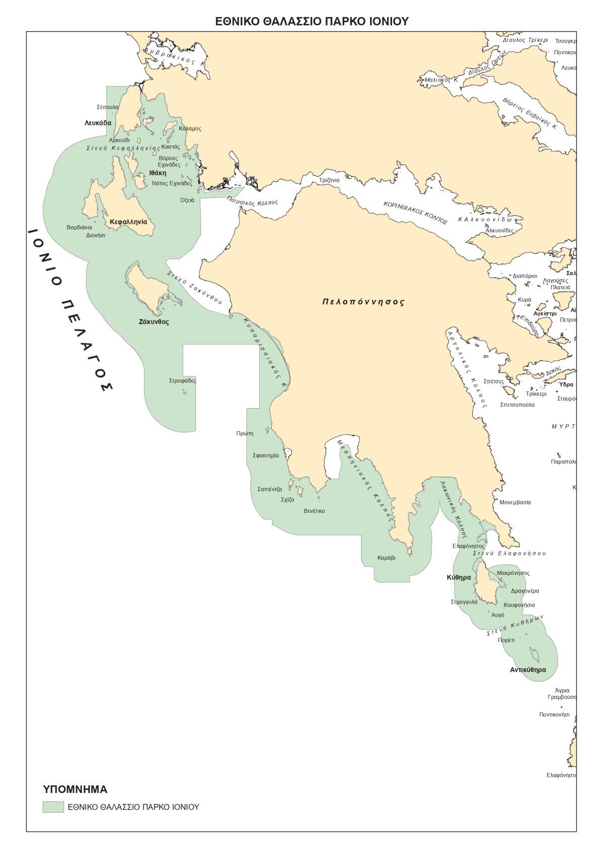
Greece revealed on Monday the boundaries of two planned marine parks in the Ionian and Aegean seas, with Prime Minister Kyriakos Mitsotakis saying they will be the largest in the Mediterranean region.
Athens wants to establish the parks, for the protection of sea mammals and turtles in the Ionian Sea and for seabirds and seals in the Aegean, this year.
Mitsotakis said they will help the country meet its global commitment to expand marine protected areas to 30% of its waters by 2030.
"They will allow us to meet the target ... way ahead of schedule," Mitsotakis said. 
"They will be vast sanctuaries for life beneath the waves," he said, adding that trawling of the sea floor will be banned inside the zones.
The environmental studies on the parks' boundaries were submitted on Monday for public consultation until September 22.
The planned Aegean Sea park has previously stirred tensions between Greece and neighbouring Turkey, with the two countries at odds over a range of issues including maritime boundaries.
Athens has said the park's boundaries are within Greece's territorial waters.

Turkey's Foreign Ministry said Greece was exploiting universal values such as environmental issues, that the parks would have no legal bearing on disputes between the neighbours in the Aegean and Mediterranean, and that Turkey will announce its own projects for marine life protection in coming days.
"Unilateral actions should be avoided in closed or semi-enclosed seas such as the Aegean and the Mediterranean," it said in a statement, adding Ankara was ready to work with Athens as a fellow Aegean coastal state to address any outstanding disputes while the NATO allies try to maintain positive sentiment.
The Aegean park, at 9,500 square kilometres, will initially expand around the southern Cyclades islands, further south from Turkey, according to the maps Greece submitted on Monday, along with the environmental studies.

The size of both parks is seen at 27,500 km2, government officials said, and Greece wants to expand them further.
When the public consultation ends, the Environment Ministry will draft two presidential decrees, which will be submitted to the Council of State by the end of October, the officials added.
 
Greece ENC coverage (HNHS)
 
The entire Ionian Sea to south Peloponnese arc, along with the southern Cyclades region — selected for the new parks — are known for their rich marine biodiversity and cultural significance.
The government emphasized that the implementation of these marine parks will take place in close collaboration with local communities, professional fishing bodies, researchers and international partners.
 
The parks will be established once the decrees are published.
 
Links :