Saturday, June 17, 2023

Image of the week : collision between racing boats


Links :


Friday, June 16, 2023

US (NOAA) nautical raster charts update in the GeoGarage platform


Plymouth harbour 1857
 
Plymouth harbor with the GeoGarage platform (NOAA nautical raster chart)


Greece boat disaster leaves at least 78 dead and hundreds missing


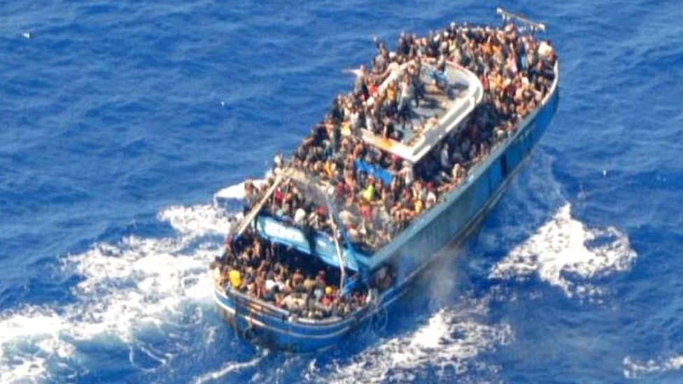
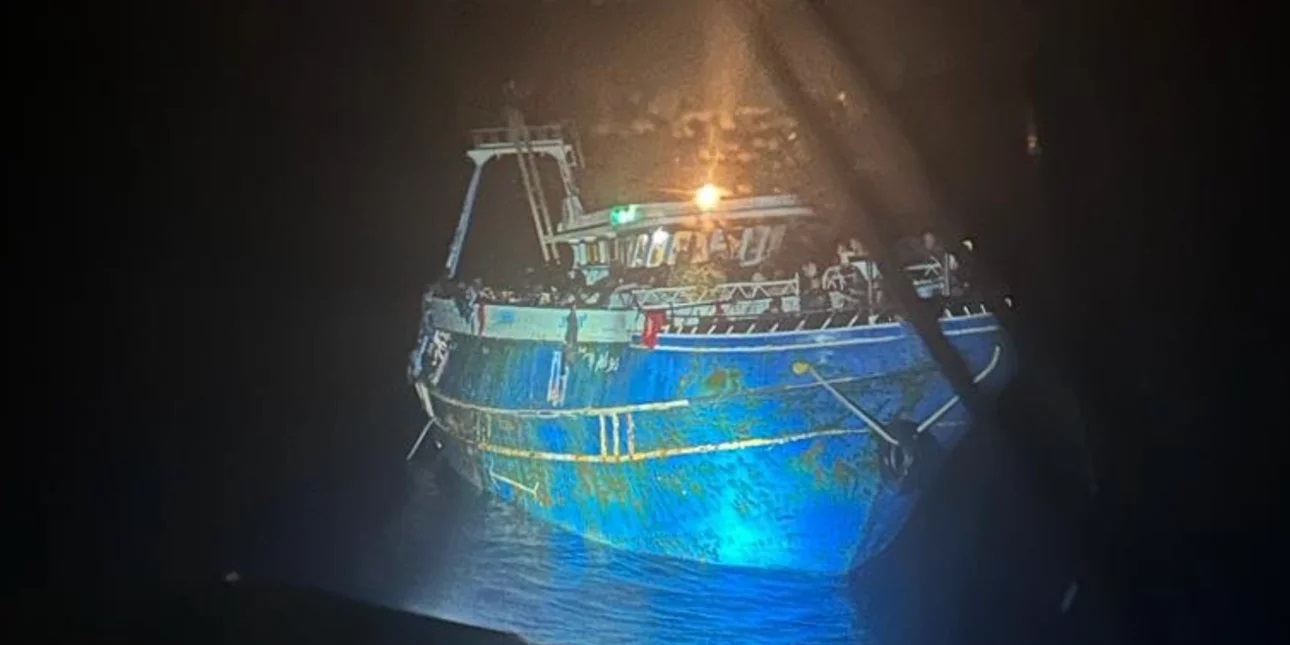
The Greek coastguard released images of the crowded boat before it went down
image : Hellenic Coast Guard

From BBC By George Wright & Laura Gozzi

At least 78 people have died and more than 100 have been rescued after their fishing boat sank off southern Greece.

But survivors have suggested as many as 750 people may have been packed on to the boat, with reports of 100 children in the hold.
Greece says it is one of its biggest ever migrant tragedies, and has declared three days of mourning.

Authorities say their offers of aid were refused but they are facing claims of not doing enough to help.

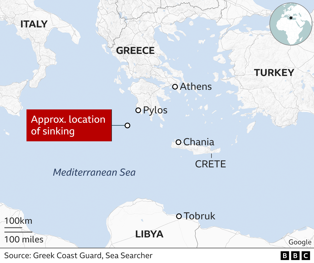
The boat went down about 80km (50 miles) south-west of Pylos after 02:04 on Wednesday morning local time, according to the Greek coastguard, which lowered an earlier confirmed death toll of 79 to 78.

The EU's border agency Frontex said it had spotted the boat early on Tuesday afternoon and immediately told Greek and Italian authorities.
The coastguard said later that no-one on board was wearing life jackets.


A photo of the migrant boat shortly before it sank.
Credit: Hellenic Coast Guard
 
In a timeline provided by the coastguard, it said that initial contact was made with the fishing boat at 14:00 (11:00 GMT) and no request for help had been made.

It said the Greek shipping ministry had made repeated contact with the boat and was told repeatedly it simply wanted to sail on to Italy.
A Maltese-flagged ship provided food and water at around 18:00, and another boat provided water three hours after that, it added.

Then at around 01:40 on Wednesday someone on the boat is said to have notified the Greek coastguard that the vessel's engine had malfunctioned.
 

Shortly afterwards, the boat capsized, taking only ten to fifteen minutes to sink completely.
A search and rescue operation was triggered but complicated by strong winds.

Alarm Phone, an emergency helpline for migrants in trouble at sea, complained that the coastguard was "aware of the ship being in distress for hours before any help was sent", adding that authorities "had been informed by different sources" that the boat was in trouble.

It added that people may have been scared to encounter Greek authorities because they were aware of the country's "horrible and systematic pushback practices".

Jérôme Tubiana of Médecins Sans Frontières told French radio that European and Greek authorities should both have intervened earlier.
"It's really shocking to hear that Frontex flew over the boat and no-one intervened because the boat refused all offers of help... an overloaded boat is a boat in distress."

The boat is thought to have been going from Libya to Italy, with most of those on board believed to be men in their 20s.

They had been travelling for days, according to local media reports, which added that the boat had been approached by a Maltese cargo ship on Tuesday afternoon that supplied food and water.

Survivors spoke of as many as 500 to 750 people on board and regional health director Yiannis Karvelis warned of an unprecedented tragedy: "The number of the people on board was much higher than the capacity that should be allowed for this boat."
One survivor told a hospital doctor in Kalamata that he had seen 100 children in the hold.

Coastguard Cpt Nikolaos Alexiou told public TV that the boat had sunk in one of the deepest parts of the Mediterranean.


The migrant vessel bound for Italy was first spotted roughly 45 miles southwest of Pylos.

The nationalities of the victims have not yet been announced.

Survivors have been taken to Kalamata, and many were treated in hospital for hypothermia or minor injuries.

Public broadcaster ERT said that three people suspected of being the traffickers had been taken to the central port authority in Kalamata and were being interrogated.

Greek President Katerina Sakellaropoulou visited some of those rescued and expressed her sorrow for those who had drowned.

Each year, hundreds of people die trying to cross the Mediterranean.
In February, a boat carrying migrants capsized near Cutro, in the region of Calabria in southern Italy, killing at least 94 people - one of the deadliest incidents recorded.
 
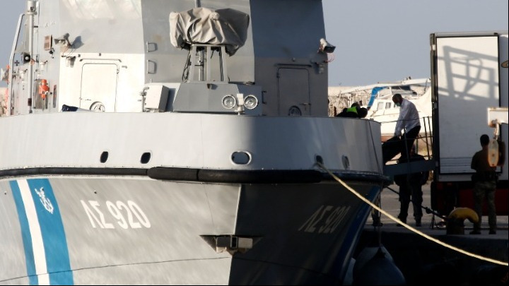
Greek officials in the gruesome task of transferring bodies from Greek Coast Guard vessel.
Credit: AMNA

Greek migration ministry official Yiorgos Michaelidis said Greece had repeatedly called for a "solid" EU migration policy "in order to accept people who are really in need and not just the people who have the money to pay the smugglers".
"Right now, the smugglers are the ones who decide who comes to Europe," he told the BBC.
"The case is for the EU to provide asylum, help and safety for those who are really in need.
It's not a problem of Greece, Italy or Cyprus… The EU is the one that must conclude on a solid migration policy."

Greece is one of the main routes into the European Union for refugees and migrants from the Middle East, Asia and Africa.

Last month the Greek government came under international criticism over video footage reportedly showing the forceful expulsion of migrants who were set adrift at sea.

More than 70,000 refugees and migrants have arrived in Europe's front-line countries this year, with the majority landing in Italy, according to UN data.
 
Links :

Thursday, June 15, 2023

NTSB determines causes of cruise ship striking Sitka pier : overreliance on Electronic Chart

The Sitka Sound Cruise Terminal pier is shown on June 9, 2022, with barge alongside the damaged dolphin for repairing (with catwalk removed)
photo: NTSB

From Seatrade Cruise News by Anne Kalosh

Overreliance on an electronic chart, miscommunication and an outdated navigational chart were all factors in Radiance of the Seas damaging a cruise terminal pier last year near Sitka, Alaska, the National Transportation Safety Board said Tuesday.
 
photo: NTSB

The Royal Caribbean International ship was docking at the Sitka Sound Cruise Terminal on May 9, 2022 when it struck and damaged a mooring dolphin.
The ship sustained a minor hull indentation.
The mooring dolphin sustained damage to three of the four pilings supporting it.
 
Area where Radiance of the Seas contacted the Sitka Sound Cruise Terminal mooring dolphin, as indicated by a red X. (Background source: Google Maps)

Timeline of Incident (Credit: NTSB)

$2.1m in damages and rest of season impacted

There were no reported injuries to the 1,375 passengers, 782 crew and four pilots on board.
The contact resulted in $2.1m in damages to the pier and impacted cruise ship traffic to the Sitka Sound Cruise Terminal for the remainder of the 2022 season.
 
Damaged Dolphin Piling (Credit: Halibut Point Marine Services)
 
In April 2021, the Sitka Sound Cruise Terminal pier was extended by 395 feet, including adding two mooring dolphins connected by a walkway and a 410-foot-long floating dock next to the existing dolphins.

NOAA not informed of pier extension


The terminal did not inform the National Ocean and Atmospheric Administration, the agency in charge of updating US coastal nautical charts, of the extension.
NOAA had no record of the construction until NTSB investigators informed them of the pier’s extension after the contact.
At the time of the contact, the electronic navigation chart (ENC) the cruise ship was using did not show the extended pier or added dolphins.
 
ENC updated postcasualty (left) and as seen on Radiance of the Seas’s ECDIS (right) with the ship’s outline after mooring shown in orange.
 (Sources: NOAA [left] and Royal Caribbean Cruise Lines [right])

Radiance of the Seas crew relied heavily on the vessel’s electronic chart and information system (ECDIS) to plan and execute their docking.
The master and bridge team had other navigational technologies, including radars and cameras, available to assist them with the approach to the terminal.
Even with these tools available, the crew relied solely on the ECDIS, which showed an inaccurate ENC.
 
Satellite view (Maxar/Google Earth)
 
NOAA 17324 raster chart (1:40:000 - Mar / 13 - NM : 06/24/23 , LNM : 06/06/23)
without extension of Sitka Sound Cruise Terminal pier
in the GeoGarage platform
(Chart will be canceled on 11/01/23)
 
 US5AK3FM ENC
Title : Sitka Sound to Salisbury Sound; Inside Passage;Neva Str.-Neva Pt. to Zeal Pt.
United States
Scale : 40000 / Cat : 5 / Type : Harbor
Edition_date : 20130820 / Edition : 10
Update_date : 20230508 / Update : 2


Master-bosun miscommunication

While docking, the bosun and master did not confirm the type of distances that were being communicated.
The bosun was relaying accurate distances to the pier’s northernmost dolphin, but the master incorrectly assumed the bosun was calling out how much clearance the ship would have as the stern passed the dolphin.

The NTSB determined the probable cause of the contact was the master and bridge team’s overreliance on an electronic chart to identify the pier’s position relative to their planned rotation location, and the master’s misunderstanding of the clearance distances to the pier being called by the crew member on the stern while the vessel was rotating.
Contributing was the Sitka Sound Cruise Terminal not reporting the extension of the pier into the waterway to the appropriate hydrographic authority in order to update the relevant navigational chart.

Lessons learned
 
NTSB investigators cited two lessons learned as a result of the investigation: voyage planning and reporting port or terminal modifications.

'Proper voyage planning includes developing a complete plan for every phase of the voyage, from the vessel’s starting port to its end port (berth to berth), including leaving the dock and mooring,' the report said.
'Reference points for maneuvering should be identified, measured precisely and reported clearly.
Vessel bridge teams should also ensure that they have the most up-to-date data before getting underway and consult with the local pilot(s) on the accuracy of navigation charts to ensure depictions of ports and/or terminals are correct.

'Ports and terminals should immediately report significant modifications to port or terminal configurations to the appropriate hydrographic authority (for example, the National Oceanic and Atmospheric Administration) so that charts can be updated and the changes made readily available to vessel owners, operators, and crews/bridge teams,' the report continued.

The full marine investigation report is available here.

Links :

The cyber vulnerabilities of dynamic positioning systems

 
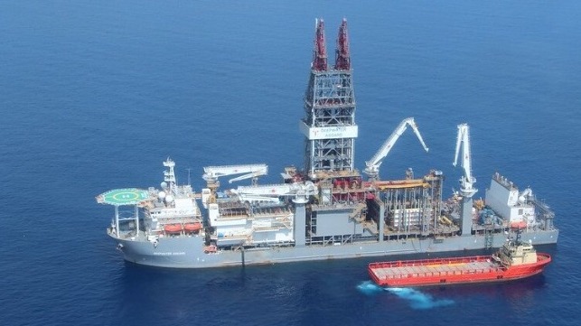
DP systems are mission-critical for drillships and deepwater MODUs
(BSEE file image)


From Maritime Executive by Jessie Hamiil-Steward and Andrew Saillay

A dynamic positioning (DP) system is an automated and computerized system which directs and monitors a vessel’s position using various onboard sensors and drives the vessel forward using propellors and thrusters.
The system is often used in research ships and drilling vessels, as well as vessels used for installation and maintenance of offshore assets.
DP systems enable crew to maintain position for various types of operations without being anchored.
Because of their computerized and connected nature, DP systems are at risk of cybersecurity attacks.

There are three levels of DP systems, which build upon one another.
They are distinguished by the level of redundancies in case of failure and the precision required for different operations.
A more sophisticated DP system will have more thrusters to control the vessel’s position.
Regarding backups, Level I is the most basic, with few redundancies, while Level III contains backups in multiple systems.
DP systems are closely linked to many different physical components on a vessel, including the propulsion system, thrusters, rudders (if any), environmental sensors, generators, position reference systems and autopilot functionality.
Their connection to physical components increases the potential gravity of a successful cyberattack on a DP system.

Crews are dependent on functional DP systems in order to achieve their objectives, especially in situations that require precise positioning for extended periods of time.
Disruptions could result in unplanned downtime or even a health, safety, or environmental incident if the control and redundancy of DP systems is lost.
Disruptions could cost time and money.
Environmental or safety incidents could have more severe ramifications, up to and including the loss of life, particularly during underwater maintenance and inspections.

DP systems are also characterized by open interconnectivity, which leaves components exposed to cyberattacks.
For instance, primary and secondary components are not protected from exposure under Level II redundancies.
Therefore, DP systems could be targeted with malware which compromises connected power management functions.
They are also connected to and controlled by an additional computer onboard a vessel, so that if the computer system that controls the DP system is infected with malware, control of the DP system could be lost too.

Finally, DP systems have difficulty distinguishing between legitimate and illegitimate commands and broadcasts.
As a result, they could be targeted with botnets, which emit a false network broadcast.
DP systems are vulnerable to taking illegitimate actions which affects its connected components.
For instance, a change of direction could take a vessel off course, potentially jeopardizing a mission.

Similarly, DP systems are dependent on GNSS signals for reference points to guide its positioning function.
They are therefore vulnerable to spoofing, whereby false signals look like legitimate GNSS signals.
It could be deceived into thinking it is in a specific location, even if its position has shifted due to current or wind, which is especially concerning given that the DP system controls the vessel’s propulsion.

Jamming is an additional concern, as the system could not accurately remain in the same position without assistance of GNSS positioning signals.
GPS jamming was observed throughout 2018 and 2019 in northern Norway, but severe consequences were luckily avoided.
However, more than 280 vessels were reportedly affected in another jamming incident in South Korea, which completely disrupted some GPS signals and resulted in incorrect data for some others.
As DP systems are deeply affected by GPS spoofing and jamming, this cyber threat remains real and serious.

The risk is not entirely theoretical and some attacks have already happened.
In one instance, there was a loss of all analogue and digital RBUS input/output (I/O) signals, subsequently leading to loss of DP systems control, resulting in vessel position drift-off, 240m from the original position.
The issue was resolved with a firmware update, and it was a clear sign that this fundamental system can be disrupted.

In another case in 2017, the DP system of an oil drilling rig contained a virus which went undetected for nearly nineteen days.

The importance and vulnerabilities of DP systems makes implementing cyber measures crucial.
An end-to-end approach is recommended in order to tackle the cyber threat, alongside awareness, training and regular assessments of cyber threats.