Tom Cunliffe introduces and extract from Taken by the Wind
Memoirs of a
1970s pacific voyage, which reveals a time when sailors had to rely on
their own pilotage skills for safe passage
From YachtingWorld by Tom CunliffeMike Jacker is a retired orthopaedic surgeon living in Illinois. Among many other activities he still sails his boat, now mainly on Lake Michigan, but he has a long memory.
In 1976, shortly after graduating from college, he and two friends set off in a Cal 30 production yacht from New Orleans for a year’s cruise in the South Pacific.
The unusual thing about his account of this voyage is that it was not written until 2020, looking back on a different age with all the wisdom of a life fully lived.
I sailed away into the blue myself at the same time, and I find his notes on the total lack of backup, no weather forecasting, no GPS and no communication with the outside world, ring absolutely true. Nobody sailing with all the benefits available in the modern world should forget that, just one lifetime ago, things were very different indeed.
We join Mike and his shipmates leaving Belize, bound on a tricky traverse to Panama…
Taken by the Wind extract
On 15 September 1976, we cast off Rhiannon’s dock lines and cleared the mud bar at the mouth of Haulover Creek.
We were officially destined for the Panama Canal Zone, conservatively estimating arrival within two weeks.
We had already learned from experience that potential calms, equipment failures, and headwinds precluded overly optimistic predictions for any passage.
In letters mailed from Belize to our families back home, we even added a few extra days to our estimates.
We never wanted relatives to believe that we might be overdue in port.
If we did not contact them when they expected, we feared that perhaps they might initiate some sort of search for us; we were already dealing with enough angst of our own without any added concerns about someone launching an unwarranted search.
Mike Jacker taking a sun sight in the Pacific
We never filed any sort of float plan or formal itinerary. In most places we were travelling, no organised search agency or rescue authority even existed.
Louis, Clark, and I knew that we were always alone, dependent on our own ingenuity and the limited resources of our fragile little boat.
A quick glance at any map or nautical chart of the Western Caribbean immediately reveals the most prominent coastal feature.
The eastern point of land in Central America where the Coco River forms the border between Honduras and Nicaragua, is a cape known as Cabo Gracias a Dios.
When voyaging southward along the Central American coast, one must travel eastward against the prevailing contrary wind and current to pass this formidable promontory.
The name, meaning ‘Thanks to God’, is attributed to Christopher Columbus.
On his fourth voyage in 1502, coincidentally also during September, Columbus required 29 days of rough sailing to reach this cape from Trujillo on the northern Honduras coast.
He endured horrible storms and endless headwinds before finally turning south into fair weather.
The passage was so miserable, even for the great ‘Admiral of the Ocean Seas’, that he gave thanks to God for rounding this point of land. Louis, Clark, and I were not bold explorers, but we fully understood the reputation of Cabo Gracias a Dios and girded our loins for the impending battle.
Our course took us toward the south-east after passing the south end of Turneffe Island. Cabo Gracias a Dios lay some 325 miles away.
We remained well offshore of Glover Reef, attempting to make as much easting as possible.
We then continued south on a port tack in moderate south-east winds.
On the second evening I noted that ‘we saw a magnificent rainbow, a meteor that lit up the area as day… and several flying fish landed on the deck’.
Clark and Mike sailing in the Marquesas
Later that night we tacked back and forth, rail down, as we were struck by intermittent gusty squalls packing 35-knot winds.
Rhiannon punched into the steep waves.
Despite the slog, we only made 10 miles of easting all night. During that night, we spoke to a nearby freighter by radio.
They provided a favourable weather forecast for the next day.
This was welcome news, especially considering our disheartening progress.
The following day we reached the Bay Islands of Honduras: Roatan and Guanaja. In the distance, a rain squall including a waterspout was drifting away, leaving us in fair weather.
With our track leading directly toward the gap between the two verdant Bay Islands, we held our course, cautiously avoiding the shoals east of Roatan.
That morning the sailing was perfect!
The sea was absolutely calm, the air was warm, the skies were clear, and the islands looked magnificent.
We saw no other people or vessels, even as we later tacked toward the east, following the south shore of Guanaja.
Paradise islands
This was our first taste of enjoying an idyllic paradise all to ourselves.
Our thoughts turned in awe to the feats of the early European explorers who, amazingly, had sailed through these same waters, without even a chart.
We had no clue of the tourist playground that this virgin region would become in the following decades.
I noted in my journal that if severe weather were to crop up over the following days, we knew of a place where we could easily return to seek shelter.
After passing the Bay Islands, we continued to tack eastwards, experiencing rain squalls alternating with calms.
On the short-wave receiver we were able to pick up the Caribbean weather forecast from Miami relayed through a repeater on Swan Island.
Thankfully, there were no storms predicted for the following three days.
On September 18, during one of several rain squalls, Clark suddenly called out, “What was that?!… I just saw a huge dorsal fin.” Louis and I wore eye-glasses, so could see little through our rain-covered lenses and even less with our glasses removed.
Nonetheless, I also soon spotted our visitors. It was a pod of small black whales.
Their smooth, sleek backs repeatedly broke the surface as close as 10ft from our starboard beam. Although we could not identify them at the time, these most likely were pilot whales.
Rhiannon at Bora Bora
They disappeared as quickly as they’d arrived.
We sighted no other whales during our time in the Caribbean.
In 1976, populations of the great whales had become alarmingly small, as most species had been decimated by the whaling factory ships prowling the oceans at that time.
Unlike whales, dolphins were more abundant in the 1970s than they are today.
Over-fishing had not yet critically depleted their food sources.
Dolphins have always been man’s greatest companions at sea.
They consistently thrilled us whenever they arrived.
Sometimes solitary but usually in groups, dolphins loved to play around the bow wave, dive beneath the keel, and perform acrobatics while keeping pace alongside the boat.
I was always delighted by the random appearance of dolphins during my night watches.
Frequently, I would be alerted unexpectedly to their presence by the characteristic breathy ‘puh-heee’ sound of a dolphin exhaling and inhaling as it broke the surface.
Soon others would join the first one, cheering me through my night watch.
Often, the lively underwater chatter of a pod would reverberate loudly through Rhiannon’s resonant hull, waking the off watch as well.
During this passage, I became acutely aware of the pelagic birds, the flying fish, and the leaping tunas, as well as the playful cetaceans that entered our world.
In truth we were the strangers invading their world, aliens to the sea.
But, occasionally, other members of the land-based world also paid us a visit.
Fishing boats frequently appeared and disappeared over the horizon as we neared coasts.
Aircraft contrails occasionally crossed the sky.

Rhiannon in the Panama Canal
However, to me, the most notable visitors were the ones who, like us, were most removed from their own element.
I easily empathised with the shore birds that had been lost or blown off course, ending up at sea.
I imagine that those birds, not accustomed to long overwater migration, would often meet death in the waves as soon as they became exhausted.
A few were lucky and found Rhiannon, the witch, transporting her own ‘three birds’.
Off the coast of Honduras, just beyond sight of land, on September 18, two small land birds came aboard.
One was a finch, and the other a smaller yellow-throated bird.
They walked over Clark as he lounged in the cockpit and took turns exploring the cabin.
As we tacked back toward the coast, they swiftly departed the moment land was in sight.
These visits aboard our floating home were always magically uplifting.
Storms avoided
Fortunately, we never met the fierce storms and daunting conditions described by Christopher Columbus.
However, consistent east winds forced us to tack back and forth repeatedly.
All afternoon on September 19, we could see a headland that we had hoped was the fabled cape.
But as we drew near, the contours of the coast and alignment of the shore informed us instead that this was Cabo Falso, the ‘false cape’ that had given Columbus false hope of having reached the true eastern promontory.
Beyond Cabo Falso, with 21 miles left to Gracias a Dios, we tacked to within 100 yards of the beach just before sunset.
A lone man was walking at water’s edge along the calm seashore.
Even though we’d been sailing for four days and were so close to the Honduran coast, we did not land.
As darkness fell, we cautiously came about onto starboard tack to head back offshore.
As long as the wind blew, we needed to continue toward Panama without stopping.

Louis tending lines on the foredeck in the Panama Canal
We then faced our greatest navigational dilemma thus far.
The sky had become overcast, and the wind had backed slightly to the north-east at about 15 knots.
This wind was perfect for a night rounding of the Cape.
However, there were no lighthouses, buoys, or other aids to navigation.
The charts indicated multiple areas of shoal water inshore, as well as many small reefs and islets, called Miskito Cays, extending well offshore from the Cape.
A cloudy sky prohibited celestial navigation.
Coastal piloting without any visible landmarks on shore would have been impossible in the dark.
We knew that dead reckoning using the compass would surely be helpful.
But strong, uncharted currents of uncertain direction precluded safe rounding of the Cape using only the compass and sumlog.
Unfortunately, the nearest radio beacons were scores of miles away.
Therefore, we carefully studied the charts to consider our alternatives.
One plan would involve sailing far offshore, bypassing all the hazards near the coast. But that would add a full day to our trip.
The sailing attire of the time protects against squalls
Following the contours
Just then I saw another possible way forward.
I ran my idea past Louis and Clark. A contour line on the chart denoting a depth of four fathoms (24ft, or 7m) described a broad, meandering arc that rounded the entire Cape while threading between all the obstacles.
The north-east wind would enable us to navigate the entire passage, sailing on a comfortable reach. We all agreed this would be our plan.
Next, we confirmed that our depth sounder was functioning properly.
Just in case the depth sounder might fail, we readied our lead line as a backup.
The flashing red dot on the face of the circular depth sounder indicated we were in 50ft of water.
We eased the sails, falling off toward shore.
Slowly, the bottom rose toward Rhiannon’s keel as we met the shallow water.
At just under 25ft, we intercepted the imaginary four-fathom contour line and adjusted our course.
For the next four hours, all three of us remained vigilant on deck.
We passed several unlit fishing stakes but otherwise kept well clear of hazards, as we walked a virtual tightrope between the prominent point and the treacherous reefs.
Once we had successfully passed Cabo Gracias a Dios, feeling immense relief, we set our course offshore, toward Panama. Louis, Clark, and I had accomplished in days what had taken Columbus weeks.
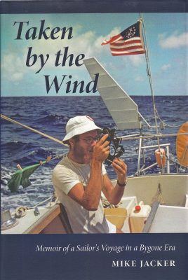


 Photo : Christian Morel