Saturday, June 16, 2012

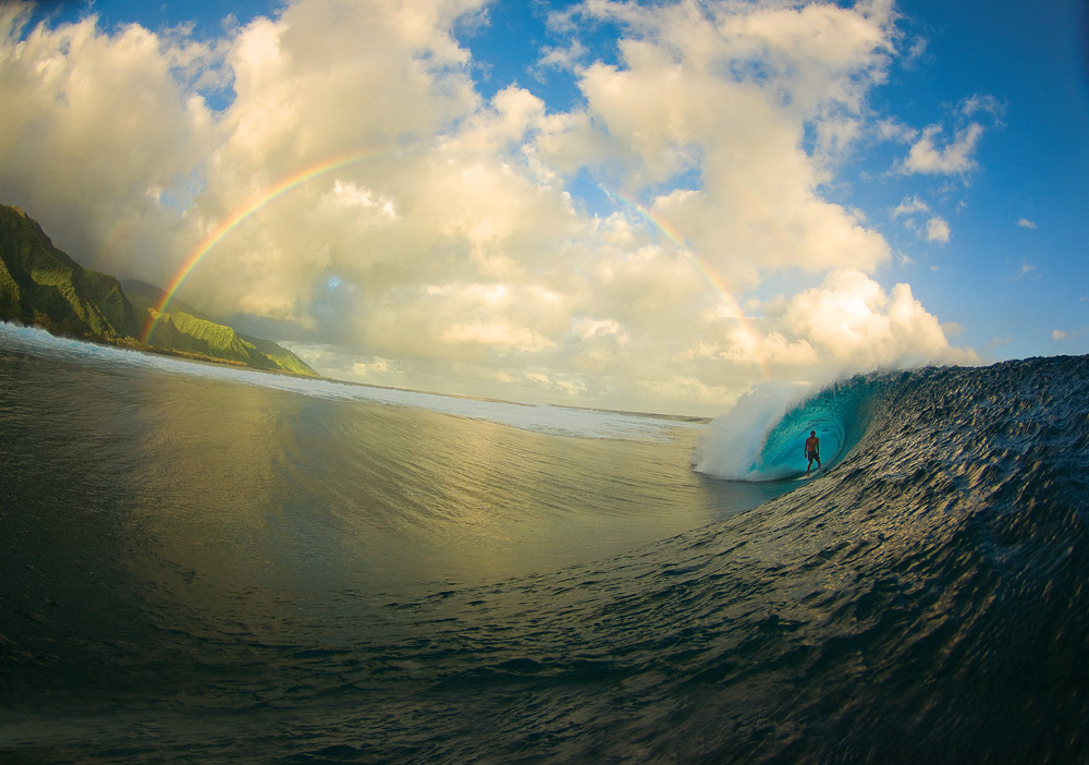
Image of the week : zen moments

2011 was certainly a good year to be in Tahiti.
One of the best water photographers in the biz, Zak Noyle, left his home island of Oahu with a small crew bound for Teahupoo.
Talent is great when it comes to photography, but a little bit of luck never hurts either.
Nature provided for this shot with a perfect peeling tube ridden by Christian Redongo, and the kind of rainbow that postcards are made of.

Crystal Thornburg, walking on water in Central California. Photo: Burkard

Friday, June 15, 2012

Turning points in modern aquaculture


Turning Points in Modern Aquaculture - this 15-min video was produced by the Aquaculture Service of the FAO Fisheries and Aquaculture Department for the Global Conference on Aquaculture 2010 and the Fifth session of the COFI Sub-Committtee on Aquaculture held in Phuket, Thailand in October 2010.

With film clips taken from various countries and photos contributed by many - depicting the range of people, species, environments, systems, practices as well as opportunities and challenges facing aquaculture, this video takes viewers to a historical journey to the major turning points in aquaculture development since the early and first aquaculture practice by a Chinese named Fan Li two millennia ago.

These four watersheds span 25 years from the Kyoto Strategy on Aquaculture Development (1976), to the establishment of the Code of Conduct for Responsible Fisheries (1995) through to The Bangkok Declaration and Strategy for Aquaculture (2000) and immediately followed by the creation of the Committee on Fisheries Sub-Committee on Aquaculture (2001) - enough to nourish its development through the next 25 so that aquaculture, now the fastest growing food producing sector can serve the people better, and communities and nations continue to prosper.

Thursday, June 14, 2012

Jackspot has been fishermen's dream

 White Marlin Open Tournament Ocean City Maryland

From Delmarvanow

Of all the famous places scattered across an offshore fishing chart, none rival the history and reputation of the shoal that lies about 20 nautical miles southeast of Ocean City's inlet and known as the "Jackspot."

>>> geolocalization with the Marine GeoGarage <<<

Surrounded by 85-115 feet of water and rising to within 50-feet of the surface, the depth changes at the Jackspot create increased current flow and upwellings that attract both predator and prey of all sizes and species.

These days, when billfish are thought of as mostly canyon fish, it's probably hard to comprehend that the Jackspot is a big reason why Ocean City is known as the "White Marlin Capital of the World."

But back in the '50s and '60s, it was the place to go if you wanted to tangle with a white or blue marlin.
The Jackspot was the billfish hot-spot for a lot of years, but by the '70s its reputation shifted to becoming the place to go to consistently troll-up a catch of big bluefish.


Though marlin were still caught on the Jackspot, hooking one became a tough thing to do with so many schools of hungry blues waiting to swarm on and shred every marlin bait that hit the water. That prompted bill-fishermen to push farther offshore and leave the Jackspot in their wake as they looked for water with hungry marlin and less bluefish.

Even though it was no longer a destination for billfish, the Jackspot was far from being down for the count.
Bluefish remained strong throughout the '80s and '90s, but anglers found that if they trolled a little faster they could avoid a few of them and have a decent chance of hooking into a tuna, dolphin, bonito, or king mackerel.


For a lot of years, the "Spot" held the reputation for being one of the hottest places to be on the East Coast to hook a tuna and boats routeenly traveled all the way from Indian River and Cape May to get in on the fun.
During the '90s, when chunking was king, it would not be uncommon to see as many as 200 boats anchored on the shoal trying to land a limit of blue and yellowfin tuna.

Even after the mother-lode of tuna shifted their residence to the "Hotdog" and "Hambone," the Jackspot continued to provide anglers with consistent summertime action with king mackerel, bonito, bluefish, false albacore, and dolphin.


Recently, the king mackerel and big bluefish have been scarce, but the bonito and dolphin have continued to keep fishermen happy, and in September the false albacore have been showing up on the shoal and making for some of the best light tackle action on the East Coast.
As if all that wasn't enough, as a part of the Ocean City Reef Foundation's network of artificial reefs the Jackspot has been the recipient of many barge loads of subway cars and other reef building material making it a destination point for bottom fishing as well.

Maybe, compared to some points in history, the action on the Jackspot has been rather pale lately, and consequently there haven't been too many anglers fishing it.

But in just the few days I fished there last season we caught, sea bass, jacks, bonito, false albacore, sharks, bluefin tuna, dolphin and bluefish, and I'm looking forward to giving the old shoal a good working over again this year.

While I don't expect we'll catch any marlin, I'm sure we'll find plenty of "something" prowling about that will make for some great fishing and pleasant memories of the good old days!

Wednesday, June 13, 2012

Hawaii’s beaches are in retreat, and its way of life may follow


From NYTimes

Little by little, Hawaii’s iconic beaches are disappearing.
Most beaches on the state’s three largest islands are eroding, and the erosion is likely to accelerate as sea levels rise, the United States Geological Survey is reporting.

Though average erosion rates are relatively low — perhaps a few inches per year — they range up to several feet per year and are highly variable from island to island and within each island, agency scientists say.
The report says that over the last century, about 9 percent of the sandy coast on the islands of Hawaii, Oahu and Maui has vanished.
That’s almost 14 miles of beach.

Beaches like Waikiki face accelerating erosion, a new report says.

The findings have important implications for public safety, the state’s multibillion-dollar tourism economy and the way of life Hawaiians treasure, said Charles H. Fletcher, who led the work for the agency.
“This is a serious problem,” said Dr. Fletcher, a geologist at the University of Hawaii at Manoa.

Sea level does not rise uniformly around the world, and so far, Dr. Fletcher and other geologists said in interviews, Hawaii has escaped some of the rise that has occurred elsewhere as earth’s climate warms.
But that situation is unlikely to continue, the report says.

Hawaii’s geological history also leaves it unusually vulnerable.
The islands formed, one by one, as a tectonic plate carrying them moved to the northwest over a “hot spot,” where a plume of molten lava pushes through the seafloor.
Over the millenniums, this material cools, accumulates and eventually rises above the waves. (Loihi, an underwater — for now — mountain southeast of the island of Hawaii, is the latest to undergo this process.)

But once the slow plate movement carries an island away from the hot spot, its volcanic material begins to compress, causing the island to start to sink, worsening its erosion prospects.

The new analysis, “National Assessment of Shoreline Change: Historical Shoreline Change in the Hawaiian Islands,” is the latest in a series of reports the geological survey has produced for the Atlantic and Gulf Coasts, California and some of Alaska.
Over all, their findings are similar: “They all show net erosion to varying degrees,” said Asbury H. Sallenger Jr., a coastal scientist for the agency who leads the work.

He said the studies aimed to establish a baseline from which scientists could “really assess what sea level rise actually does in the future to our coasts.”

S. Jeffress Williams, another scientist with the agency, said researchers had over the years produced a number of studies of Hawaii’s shorelines, using various methods of data collection and analysis. “Many were well done, but it is sort of mixing apples and oranges,” he said, referring to the need to adopt standard study methods.
The new work aims to allow researchers to compare data from states around the country.

And though it seems self-evident that erosion must be tied to rising seas, “you have to document it,” Mr. Williams said.
“Sea level rise is only one of the driving forces that control what happens at the shoreline.”
For example, he said, on a beach that receives a steady influx of sand, “you can have marginal erosion or stable or even accreting shorelines.”

But that is not ordinarily the case in Hawaii, where the typical response to erosion has been to protect buildings with sea walls and other coastal armor.
“It’s the default management tool,” Dr. Fletcher said.
But in Hawaii, as nearly everywhere else this kind of armor has been tried, it results in the degradation or even loss of the beach, as rising water eventually meets the wall, drowning the beach.

He suggested planners in Hawaii look to American Samoa, where, he said, “it’s hard to find a single beach. It has been one sea wall after another.”

But the most common alternative approach, replenishing beaches with pumped-in sand, is difficult in Hawaii, where good-quality sand can cost 10 times as much as it does on the East Coast, Mr. Williams said.

Dr. Fletcher said he believes the answer lies in encouraging people to move buildings and other infrastructure away from the shoreline, a strategy coastal scientists call retreat.
“If we want beaches we have to retreat from the ocean,” he said.
But, he added. “It’s easy to say retreat; it’s much harder to implement it.”

Dr. Sallenger said he hoped the work in Hawaii and elsewhere would help policy makers.
“We don’t define what rules and laws are written about coasts and exactly how they are managed,” he said, “but this is information that can be factored into that process.”
Tuesday, June 12, 2012

The first underwater photo


The oceanographer and biologist Émile Racovitza is seen here diving with a helmeted diving suit. Photograph by Louis Boutan, taken in 1893 at Banyuls-sur-Mer.

Although the British photographer William Thompson took photographs as early as 1856 by immersing his camera, it was the French biologist Louis Boutan who developed the techniques of underwater photography at the oceanic laboratory in Banyuls-sur-Mer (Pyrénées- Orientales).
At the end of the 19th century, in order to study marine fauna and flora, he started diving in a diving suit but found it very frustrating not to be able to bring back images.
With the help of Joseph David, a mechanic, he developed a watertight housing for his camera, with copper walls and small round windows for the lens and viewfinder.
Ingenuity is the key
But the box was not strong enough to withstand the pressure of the sea.
They came up with the idea of adding a rubber balloon filled with 3 litres of air.
The water pressure pushes the air from the submerged balloon into the box, balancing the internal and external pressures, and preventing the box from imploding.
The photos taken at a depth of 3 metres in bright sunlight are satisfactory.
However, at greater depths, the lack of light means that longer breaks of ten to thirty minutes are required.
The result is still blurred images.
The use of submersible electric lights allowed them to take pictures at 50 metres.
courtesy of Caminteresse

Louis Boutan was the first underwater photographer, who took pictures at a depth of 164 feet in 1893. Above — a self-portrait depicting Boutan in a full diving suit, airlines and metal helmet — was his first successful photo, and it offers us what a cumbersome chore it would have been to dive (and of course take pictures underwater) in those days.

Boutan, who was trained as a marine zoologist, conducted most of his underwater photo-experiments in 1890s at the Arago Marine Laboratory at Banyuls-sur-Mer, on France’s Mediterranean coast.
He identified many problems of contemporary cameras that rendered them useless in extreme conditions.
He tried encasing his cameras in strongboxes (including barrels); he tried completely flooding the interior of cameras.
Lastly, he built a watertight massive equipment that was able to withstand pressure (on land, three men were needed to lift it), and battery-powered underwater arc lights, he was able to take photographie sous-marine.
But still, there was no high speed film and his exposures lasted 30 minutes.
Boutan had to remain underwater for sometimes as long as three hours and suffered nitrogen narcosis. Eventually, Boutan used a magnesium powder “flash” that greatly hastened phototaking.

Links :