Saturday, March 17, 2012

Living the dream surfing Byron Bay

Byron Bay - The Meeting Place 'Trailer' from Rest Your Eyes

Thousands of years ago the Arakwal Aboriginal people recognised the rich beauty of the Byron region.
They called it Cavanbah ‘The Meeting Place’.

Located on the most easterly point of Australia’s unique coastline, Byron Bay slowly developed into a small sleepy whaling town and has now grown into one of Australia’s biggest tourist destinations with millions of visitors each year.

>>> geolocalization with the Marine GeoGarage <<<

‘Byron Bay – The Meeting Place’ is a beautiful and visually appealing 40-minute documentary that explores the journey Byron Bay has taken, and introduces the characters that have enriched the region’s culture; locals, hippies, surfers, travelers, indigenous folk, and people from all walks of life.
These people are all united by one factor, their love for Byron Bay.


The smooth surfer Jorgelina "Lina" Reyero hails from a small town on the Atlantic Coast of Argentina.
She's spent the last 6 years wandering the world with her surfboard in tow and has wound up near the beautiful Wategos Beach, 1,5 km East of Byron Bay town.
She mounted a little camera to the nose of her log and captured the beauty of an empty surf.

Friday, March 16, 2012

Wishful Mapping: a half-baked Alaska, and the passage that wasn't there

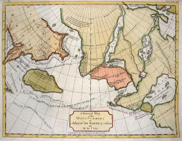
General Map of the Discoveries of Admiral de Fonte (detail version)

From BigThink

What a strange concoction this late-18th-century French map is.
Centred on the northwestern part of America, it is an eclectic mix of geographic fact and fiction. Some continental contours are instantly recognisable, for instance the Kamchatka peninsula of Russia’s Far East, and Canada’s Baffin and Hudson Bays.
But what is that thing in between, and what has it done to Alaska?

Even the mapmaker must have known there was something wrong with what he wrought.
Notice the contrast between the mostly soft-edged shores of this half-baked Alaska (
And of the wholly fictional islands to its north, floating in the Mer de Tartarie and inhabited by the mysterious Ye-Oue, or Nation des Pygmies. In the Middle Ages, 'Tartary' described all lands east of the Urals, little known in the West.), and the jagged coastlines of the real parts of the world.

Most of it corresponds to what we now consider to be Siberia (i.e. the Asian part of Russia).
The lack of detail for the former is intentional, a sign of deference by the cartographer to his lack of knowledge.
Smooth shorelines are a code between the maker and reader of maps, to be read as: Not yet surveyed.

Then take a look at the larger shape of this alternate Alaska, to the islands populating its northern shores, and to that strange strait that connects Pacific to Atlantic, while skirting both aforementioned Canadian Bays.
They’re proof of a curious constant in mapping fake geographies: even though imaginary islands, rivers and coastlines are as random as real ones, they mostly look like the fantasies they are. There’s just something inimitable about the haphazard quality of truly natural geography.

This map appeared in the third volume of
Diderot’s Encyclopédie as Didier Robert de Vaugondy’s version, dated 1772, of an English map by Thomas Jefferys (1768).
It purports to be a
General Map of the Discoveries of Admiral de Fonte, representing the great probability of a North-West Passage.


This was a popular map, as the Northwest Passage was a popular fantasy - and a prime example of wishful mapping.
The Passage found its origins in the early days after discovery, when America was still seen by Europeans as an obstacle to trade with China and Japan, rather than as an opportunity in its own right.
Its existence was first mooted in 1539 by
Francisco de Ulloa, whose voyage up the Gulf of California (the narrow body of water separating Baja California from the rest of Mexico. This peculiarity also prolonged the belief that California was, in fact, an island.) led him to propose that it was one end of a strait that ran all the way across the North American continent to the St. Lawrence River, flowing from the Great Lakes through Québec into the Atlantic.

This waterway, all the more mythical for being non-existent, started showing up on maps from the mid-16th century onward as the Strait of Anian, probably after a Chinese province mentioned in
Marco Polo’s Travels (where Anian and Toloman were mentioned together in such a way as to suggest that the former was Japan, the latter Kamchatka).
For centuries, it was one of that handful of fictional drivers of real exploration.
Others include the
Seven Cities of Gold (in North America) and El Dorado (generally sought in South America).
These places were always sought after but never found, and thus instrumental in pushing back the boundaries of the unknown.

The
Strait of Anian (or, as the British preferred to call it, the Northwest Passage), was the elusive prize of Sir Francis Drake’s visit to the North America’s West Coast (or, as he called it, Nova Albion (‘New Britain’)) in 1579.
In 1592, the Greek-born, Spanish-employed
Juan de Fuca (that’s Ioannis Phokas to his dear old mum and dad, but also sometimes Apostolos Valerianos. It’s not exactly clear to whom) claimed to have found it.
In reality, he probably sailed up the strait between Vancouver Island and the Olympic Peninsula that would later be named in his honour.

In 1609,
Henry Hudson ventured up the river that would be named after him, in search of the eastern terminus of the Northwest Passage.
He died a few years later, set adrift up north with his son and a few others by his mutineering crew into the icy bay that would later also bear his name.

An apocryphal Spanish tale has the Spanish admiral Bartolomeo de Fonte actually sail through the waterway in 1640, meeting a trading ship out of Boston that came in from the other side.

In the 1770s,
Captain Cook sailed up and down the coast of the Pacific Northwest, searching in vain for the entrance to the Strait of Anian.
His was the last, most vigorous attempt to do so.

The numerous, ever more northerly, and often deadly attempts to effect a Northwestern Passage were finally crowned with success in the early 20th century.
It took
Roald Amundsen three years (1903-1906) to make the crossing.

Too much ice and too shallow waters have always rendered this Northwest Passage uneconomical, but global warming might be changing that.
When the ice retreats far enough, the mythical waterway may yet become a reality, and finally connect the markets of the Old World with the fabled riches of Cathay and Xipangu (
China and Japan, if you were Marco Polo).

Wednesday, March 14, 2012

Looking for tsunami debris on West coast beaches


The powerful Japanese earthquake and resulting tsunami in March, 2011, washed untold tons of marine debris into the Pacific Ocean.
This video explains what NOAA is doing to help track the debris.


From NYTimes

John Anderson, a plumber by trade and a beachcomber by passion, has been trolling the shores of the Olympic Peninsula in Washington State for more than three decades, and along the way has discovered almost every kind of flotsam one can imagine: toys, refrigerators, even the occasional message in a bottle.

But in recent months, Mr. Anderson has been making a new, and somewhat surprising, find: dozens of buoys marked with Japanese writing, set adrift, he believes, by last year’s catastrophic tsunami.
“That wave wiped out whole towns, I’m thinking just about anything could show up here,” said Mr. Anderson, 58, of Forks, Wash.
“I’ve heard people talking about floating safes full of Japanese money.”


A ship floats amongst scattered debris from the city in Wakuya

The tsunami — which struck after a massive offshore earthquake last March 11 — sent a wall of water sweeping across much of Japan’s eastern coastline and generated more than 20 million tons of debris, a jumbled mass of houses, cars, boats and belongings.

A house is pictured adrift in the Pacific Ocean off the coast of Japan

And while it’s not clear what percentage of that wreckage was sucked back out to sea and what remains afloat, what is certain is that some of it is slowly making its way to American shores.


On the first anniversary of the Great Tohoku Earthquake, IPRC's Senior Scientist Nikolai Maximenko speaks about the current status of the tsunami debris that the earthquake generated.
(animated map of the projected path / tracker)

Computer models run by the National Oceanic and Atmospheric Administration and by researchers from the University of Hawaii predict that debris has moved eastward from the coast of Japan, driven by currents and wind.
The models predict that bits of detritus will begin washing up on the northwestern Hawaiian Islands this spring and along the western coast of the United States and Canada in early 2013.
“We don’t think there is a massive debris field out there,” said Nancy Wallace, director of NOAA’s Marine Debris Program.
“It will come up in little spurts here and there, a small trickle over years.”


Researchers think most of it will never reach shore and will instead get caught up and broken apart in the “great Pacific garbage patch” a swirling gyre of currents in the middle of the Pacific Ocean known to collect and recirculate floating garbage.

But beachcombers say the debris has already begun to reach land.
“I feel like Paul Revere running through town, saying ‘The British are coming!’ and no lights are coming on,” said a retired oceanographer, Curtis Ebbesmeyer.
“The tsunami debris is here, but no one is listening.”

Co-author of “Flotsametrics and the Floating World: How One Man’s Obsession With Runaway Sneakers and Rubber Ducks Revolutionized Ocean Science,” Mr. Ebbesmeyer, 69, also publishes Beachcombers’ Alert, a newsletter on all things flotsam and jetsam.
He counts some 10,000 people in the loose-knit network of serious beachcombers who read his newsletter and report their seashore findings to him.
Mr. Ebbesmeyer said he had received more than 400 documented sightings of large black plastic and white Styrofoam buoys found between Kodiak, Alaska, and Humboldt County, Calif.
Many of the buoys are marked with Japanese characters, including the names of oyster companies destroyed by the tsunami.
The buoys corroborate computer modeling by Mr. Ebbesmeyer and an oceanographer colleague that predicted debris would begin landing as early as last fall.

After the earthquake and subsequent tsunami that struck Japan on March 11, 2011, tons of debris was swept into the Pacific.
Much of it is buoyant enough to float on the surface and can be moved around by small scale currents and large scale circulation patterns, such as the North Pacific Gyre.
The gyre, bounded by the Kuroshio Current on the west, California Current on the east, and Equatorial Current on the south tends to entrain debris in the center of the Pacific basin, creating what is commonly known as the "Great Pacific Garbage Patch."
Though the bulk of the marine debris remains in the ocean for years in an area north of Hawaii, individual pieces are continually washing up on the continental and island shores that border the basin.
NOAA's Marine Debris Program leads efforts to track and remove much of this existing trash, and is currently assessing the tsunami debris.
Scientists as NOAA's Earths System Research Laboratory developed the debris dispersion model, shown here.
Using five years of historical weather patterns, the model is used to approximate how debris will circulate across the basin.
(source NOAA)


Despite a rise in interest and reported sightings, officials have not confirmed that any of the items found along the West Coast originated in Japan.
“There is debris from Asia that comes to shore all the time, and it’s not necessary tsunami-related,” Ms. Wallace said.
Thus far, only two tsunami debris clusters have been confirmed, a wrecked Japanese fishing boat spotted by a Russian ship that was en route from Honolulu to Vladivostok, Russia, and another vessel located by the United States Coast Guard nearer to Japan.

Finding flotsam over some 5,000 miles of open ocean is not easy.
A month after the disaster, the debris was no longer visible in NOAA’s satellite images.
To assist in the search, officials have requested higher-resolution satellite images from the National Geospatial-Intelligence Agency, which runs satellite-based mapping and monitoring for the Defense Department.

In recent months, NOAA reached out to the commercial shipping and fishing groups, asking boats to report any large debris sightings in the water.
NOAA has also called on a growing cadre of beachcombers to keep a lookout.
Since January, the number of e-mails NOAA has received reporting tsunami debris has increased threefold.
The Web page answering frequently asked questions about the tsunami gets more visitors than any of the program’s other pages.
NOAA also has a smartphone app for tracking debris found on beaches.

Whether tsunami-related or not, officials encourage beachgoers to pick up and properly dispose of any garbage they find.
“Radioactivity is extremely unlikely,” Ms. Wallace said, in part because the damaged Fukushima reactor did not begin leaking radioactive material until after the tsunami wave retreated.


Tom Baty, an avid fisherman and a retiree, spends up to three hours a day walking the beaches of Point Reyes National Seashore in California, where he picks up trash and sometimes tracks the location of plastic debris with a GPS device.
Mr. Baty, 54, regularly finds tidbits of junk marked with Japanese, Chinese and Korean characters, which makes him skeptical of the reports of tsunami debris up the West Coast.
Still, he said he was curiously awaiting the arrival of any floating evidence of that violent event. Mr. Baty is one of a ragtag army of unofficial seaside detectives who provide useful information on the patterns and whereabouts of ocean garbage to government officials and environmental groups.
“You walk up to something on the tide line,” he said, “and you scratch your head and think, ‘Now where did that come from?’ ”

Links :

Deep ocean floor can focus tsunami waves


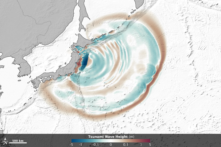
credit NASA

From OurAmazingPlanet

As the waves of a tsunami approach a coastline, the topography of the seafloor near the coast plays a major role in determining how large those waves become and what places get hit harder than others.


For example, when the waves of the massive tsunami generated by last year's magnitude 9.0 Japan earthquake crossed the Pacific Ocean and reached the U.S. West Coast, they hit Crescent City, Calif., particularly hard because of two features of the seafloor off the coast: a piece of the ocean floor raised by tectonic activity that runs directly toward the city and the position and shape of the city's harbor.

Scientists had suspected that the same phenomenon might also take place in the deep ocean, where underwater mountains, called seamounts, chasms and even islands could deflect tsunami waves in some places and amplify them in others.

But measurements taken by satellites passing over the waves of last year's tsunami have confirmed that this happens, even at large distances from a quake's epicenter.

Researchers from NASA's Jet Propulsion Laboratory and Ohio State University used satellite altimeters, which can measure sea level changes in very fine detail, to observe "merging tsunamis" — a phenomenon where smaller waves merge to form one bigger wave.
These waves can travel hundreds to thousands of miles without losing power.

The measurements showed that the March 2011 tsunami doubled in intensity when passing over rugged ocean ridges and around islands in the middle of the Pacific.

The team used a computer-based model to translate the measurements into images and animations, which shows how the waves can refract, bend and merge as they propagate.
The peaks of waves are colored red-brown, while depressions in sea surface appear blue-green. Grayscale outlines show the location of mid-ocean ridges, peaks and islands.

The measurements came from the Jason-1, Jason-2, and Envisat satellites, which each flew over the tsunami at a different location.
"It was a one in 10 million chance that we were able to observe this double wave with satellites," said Tony Song, principal investigator of the study and a scientist at JPL.
"Researchers have suspected for decades that such ‘merging tsunamis’ might have been responsible for the 1960 Chilean tsunami that killed about 200 people in Japan and Hawaii, but nobody had definitively observed a merging tsunami until now. It was like looking for a ghost," Song said. "Jason happened to be in the right place at the right time to capture the double wave."


Find out how the earthquake and tsunami of 2011 devastated Japan, in this OurAmazingPlanet infographic.

Tuesday, March 13, 2012

A census of the ocean


Oceanographer Paul Snelgrove shares the results of a ten-year project with one goal: to take a census of all the life in the oceans.
He shares amazing photos of some of the surprising finds of the Census of Marine Life.

"We can only sense that in the deep and turbulent recesses of the sea are hidden mysteries far greater than any we have solved."
~ Rachel Carson, 1907-1964.

From TheGuardian

Oceans cover more than 70% of the surface of Earth, and contain a large portion of Earth's biodiversity, much of it still unknown.
Further, we know more about the surface of the Moon and Mars than we know about the floor of the world's oceans.
To remedy this knowledge deficit, the Census of Marine Life programme was initiated to catalogue and study the distribution, diversity and abundance of life in the oceans.
The census revealed how diverse, surprising, still vastly unknown, and tenacious life is in the oceans.


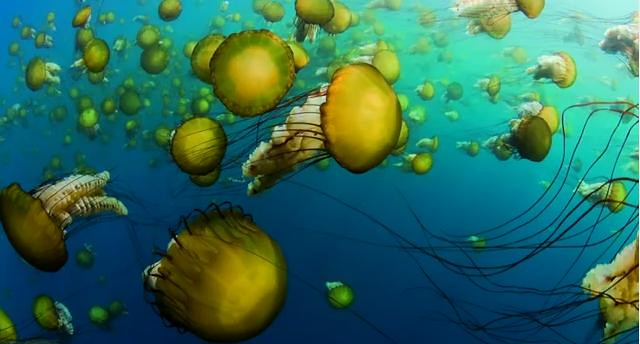
Screen grab

In this disturbing and fascinating video, oceanographer Paul Snelgrove shares some of the results of this ten-year project.
Professor Snelgrove, who compiled the data collected by this decade long marine census into a book, tells how shifting baselines have obscured our view of the loss that oceans have suffered as a result of human over-exploitation and shows us some of the amazing tools used to investigate oceanic habitats.
So far, more than 6,000 potential new species have been discovered, so Dr Snelgrove shares photographs of a few of his favourite newly discovered species.