Wednesday, June 18, 2025

NOAA predicts above-normal 2025 Atlantic hurricane season

Image of Hurricane Milton from NOAA's GOES-16 satellite on Oct. 8, 2024. (Image credit: NOAA)

 
From NOAA 
 
Above-average Atlantic Ocean temperatures set the stage
Forecasters within NOAA’s National Weather Service predict above-normal hurricane activity in the Atlantic basin this year.
 
NOAA’s outlook for the 2025 Atlantic hurricane season, which goes from June 1 to November 30, predicts a 30% chance of a near-normal season, a 60% chance of an above-normal season, and a 10% chance of a below-normal season.

The agency is forecasting a range of 13 to 19 total named storms (winds of 39 mph or higher).
Of those, 6-10 are forecast to become hurricanes (winds of 74 mph or higher), including 3-5 major hurricanes (category 3, 4 or 5; with winds of 111 mph or higher).
NOAA has a 70% confidence in these ranges.

“NOAA and the National Weather Service are using the most advanced weather models and cutting-edge hurricane tracking systems to provide Americans with real-time storm forecasts and warnings,” said Commerce Secretary Howard Lutnick. 
“With these models and forecasting tools, we have never been more prepared for hurricane season.”

“As we witnessed last year with significant inland flooding from hurricanes Helene and Debby, the impacts of hurricanes can reach far beyond coastal communities,” said Acting NOAA Administrator Laura Grimm. 
“NOAA is critical for the delivery of early and accurate forecasts and warnings, and provides the scientific expertise needed to save lives and property.” 

 
A summary infographic showing hurricane season probability and numbers of named storms predicted, according to NOAA's 2025 Atlantic Hurricane Season Outlook.
The official start of the Atlantic hurricane season is June 1 and runs through November 30.
(See also news release text for data found within above graphic.)
(Image credit: NOAA NWS)

Factors influencing NOAA’s predictions

The season is expected to be above normal – due to a confluence of factors, including continued ENSO-neutral conditions, warmer than average ocean temperatures, forecasts for weak wind shear, and the potential for higher activity from the West African Monsoon, a primary starting point for Atlantic hurricanes.
All of these elements tend to favor tropical storm formation.

The high activity era continues in the Atlantic Basin, featuring high-heat content in the ocean and reduced trade winds.
The higher-heat content provides more energy to fuel storm development, while weaker winds allow the storms to develop without disruption.

This hurricane season also features the potential for a northward shift of the West African monsoon, producing tropical waves that seed some of the strongest and most long-lived Atlantic storms.

“In my 30 years at the National Weather Service, we’ve never had more advanced models and warning systems in place to monitor the weather,” said NOAA’s National Weather Service Director Ken Graham.
“This outlook is a call to action: be prepared. Take proactive steps now to make a plan and gather supplies to ensure you're ready before a storm threatens."

Improved hurricane analysis and forecasts in store for 2025

NOAA will improve its forecast communications, decision support, and storm recovery efforts this season.
These include: 
  • NOAA’s model, the Hurricane Analysis and Forecast System, will undergo an upgrade that is expected to result in another 5% improvement of tracking and intensity forecasts that will help forecasters provide more accurate watches and warnings.
  • NOAA’s National Hurricane Center (NHC) and Central Pacific Hurricane Center will be able to issuetropical cyclone advisory products up to 72 hours before the arrival of storm surge or tropical-storm-force winds on land, giving communities more time to prepare.
  • NOAA’s Climate Prediction Center’s Global Tropical Hazards Outlook, which provides advance notice of potential tropical cyclone risks, has been extended from two weeks to three weeks, to provide additional time for preparation and response. 

The alphabetical list of 2025 Atlantic hurricane names as chosen by the World Meteorological Organization.
Find a text version of this list at hurricanes.gov/aboutnames.shtml#atl (Image credit: NOAA NWS)

Enhanced communication products for this season
  • NHC will offer Spanish language text products to include the Tropical Weather Outlook, Public Advisories, the Tropical Cyclone Discussion, the Tropical Cyclone Update and Key Messages.
  • NHC will again issue an experimental version of the forecast cone graphic that includes a depiction of inland tropical storm and hurricane watches and warnings in effect for the continental U.S. New for this year, the graphic will highlight areas where a hurricane watch and tropical storm warning are simultaneously in effect.
  • NHC will provide a rip current risk map when at least one active tropical system is present. The map uses data provided by local National Weather Service forecast offices. Swells from distant hurricanes cause dangerous surf and rip current conditions along the coastline.
Innovative tools for this yearNOAA National Environmental Satellite, Data, and Information Services (NESDIS), in collaboration with NOAA’s Office of Marine and Aviation Operations and NOAA Research, is deploying a new, experimental electronically scanning radar system called ROARS on NOAA’s P-3 hurricane hunter research aircraft.
The system will scan beneath the plane to collect data on the ocean waves and the wind structure of the hurricane.
NOAA Weather Prediction Center’s experimental Probabilistic Precipitation Portal provides user-friendly access to see the forecast for rain and flash flooding up to three days in advance.
In 2024, Hurricane Helene caused more than 30 inches of extreme inland rainfall that was devastating and deadly to communities in North Carolina.

NOAA’s outlook is for overall seasonal activity and is not a landfall forecast.
NOAA’s Climate Prediction Center will update the 2025 Atlantic seasonal outlook in early August, prior to the historical peak of the season.
 
Links :

Tuesday, June 17, 2025

GPS jamming on the rise as Israel-Iran conflict enters fourth day


 The signal of a large number of ships appeared in a circle off Haifa harbor as a result of the jamming
Continuous on the Eastern Mediterranean GPS system 
 
From Splash

The conflict between Israel and Iran stretched into a fourth consecutive day on Monday, rattling global energy markets and placing the maritime industry on edge.
While Israeli airstrikes have so far avoided directly targeting Iran’s crude oil infrastructure, a reported explosion at a natural gas plant near the massive South Pars field over the weekend has escalated concerns of broader regional destabilisation, while Iran has claimed it has successfully hit the Israeli port city of Haifa.


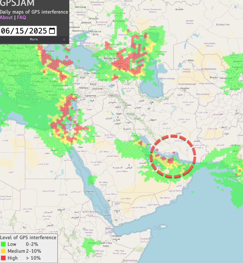
GPS jamming saw ships' AIS signals erroneously show them on land in Iran as they transited the Strait of Hormuz. 
Source: Windward Maritime AI™ Platform
 
The spectre of a widening war in the oil-rich Middle East—which accounts for nearly a third of global crude flows—has driven energy prices and tanker freight rates sharply higher, as shipowners, traders, and insurers weigh the growing risks of operating in the region.

GPS Jamming Impacts Tankers Across Strait Of Hormuz
Bloomberg reports a surge in GPS jamming around the Strait of Hormuz, scrambling navigation for more than 900 vessels and hinting at a new form of disruption for the world's most critical maritime chokepoint.
 
Amid the intensifying conflict, maritime authorities have flagged significant electronic interference affecting commercial vessels across the Middle East.
The Joint Maritime Information Center (JMIC)—part of the US-led Combined Maritime Forces—confirmed Saturday that ships operating near the Persian Gulf and eastern Mediterranean have reported false positioning signals and severe GPS jamming.

A now-familiar circular spoofing pattern was observed off the coast of Haifa, a result of distorted GPS signals, according to data reviewed by commercial tracking platforms.
The JMIC has urged ship operators to closely monitor navigation systems and prepare alternate communication and positioning methods to avoid incidents at sea.

Although Iran’s oil export terminals have not yet been hit, analysts remain focused on the potential for Iran to retaliate by disrupting traffic through the Strait of Hormuz—a vital artery through which about 20m barrels per day of crude and products transit.

While a full closure of Hormuz is seen as unlikely and logistically unsustainable, a partial disruption through harassment, seizure, or limited attacks on ships remains plausible.
 
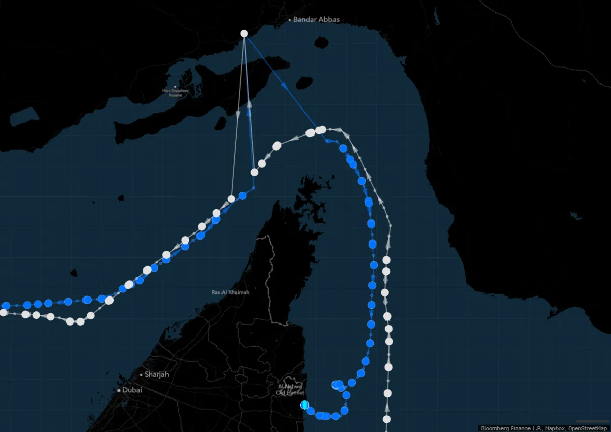
The Front Tyne (in white) and Elandra Willow (blue) were sailing through the Strait of Hormuz when they transmitted signals showing puzzling journeys near Iran’s Bandar Abbas.
Source: Bloomberg
 
Shipbroker Gibson warned that even minor disturbances could shrink the pool of shipowners willing to transit the strait, driving freight rates higher and potentially shifting demand to Atlantic Basin crude and other safer load zones.
 

There is growing concern that Iran may activate proxy forces to expand the conflict beyond the gulf. Maritime security analysts are warning that the Houthi rebels in Yemen, whose naval capabilities have been targeted by US strikes earlier this year, may resume attacks on Red Sea shipping in a show of support for Tehran.
 
The disruptions, which have affected various types of vessels, are believed to be caused by "extreme jamming" of signals from the Iranian port of Bandar Abbas.
Visualization of the Strait of Hormuz with the GeoGarage platform (NGA nautical raster chart) 
 
UK-flagged vessels were issued warnings Friday against transiting the southern Red Sea.
 

Monday, June 16, 2025

Would Iran close the Strait of Hormuz in a conflict?

  
Strait of Hormuz closure risk rises amid escalating tensions
Kpler data shows that 34% of all seaborne-traded oil has transited the Strait of Hormuz so far this year. The strait last effectively closed during the Iran-Iraq “Tanker War” in 1984 and remains a critical chokepoint for global oil and gas flows.
Tensions are rising following Israeli strikes on Iran’s Natanz nuclear facility and the deaths of senior IRGC officials, increasing the risk of wider disruption in the Gulf. If flows were interrupted, few immediate alternatives exist for the oil that moves through the strait—heightening risk for global energy markets. 
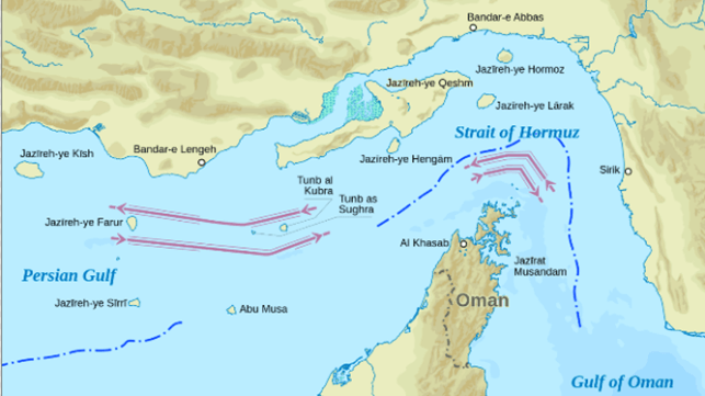
The Strait of Hormuz Traffic Separation Scheme (Wikipedia) 

From Maritime Executive 

Should Israel mount its promised counter-attack in response to the Iranian missile blitz on Israel at the beginning of the month, Iran certainly has the ability to close the Strait of Hormuz if it wished to do so.

The Iranian coastline overlooks the Strait for more than 100 nautical miles, and Iran has a large number of missiles, drones, naval and aviation systems that could threaten ships in the Strait.
Even limited Iranian attacks might be sufficient to close down traffic, should shipping companies be concerned about heightened risk and soaring insurance premiums.

Besides the frigates, missile boats and aviation assets of its regular and IRGC navies, Iran has shore batteries of anti-shipping missiles covering the strait.
The IRGC has specialized for years in speedboat swarm attacks on merchant vessels, and it also has a mining capability that would be particularly effective in the shallow and constricted waters of the strait.


But would Iran want to see conflict in the area and a closure of the waterway, which it depends on for its oil exports?

For Iraq, Kuwait, Bahrain and Qatar, the Strait of Hormuz is the only maritime link to the rest of the world; their economies are dependent on imports for basic necessities.
Given the dependency of so many nations on oil, China in particular, and the likelihood that Saudi Arabia and the United Arab Emirates would suffer a massive hit to economic confidence if the strait were to be closed, a closure of the strait by Iran would almost certainly be met by some form of military response.
 
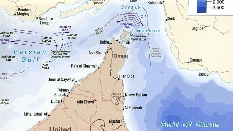
 Khark Island provides a sea port for the export of oil and extends Iranian territorial sea claims into the Persian Gulf oil fields.
Visualization with the GeoGarage platform (NGA nautical raster chart)
 
This in turn would close down the ability of Iran to use the strait for its own oil exports.
Iran generates 65% of government revenues and 8% of its GDP from such exports.
Without oil revenues, the Iranian government would be forced to cut subsidies on fuel and basic foodstuffs, which underpin the low prices enjoyed by Iran’s 91 million people.
With a large percentage of the population already deeply unhappy with the government, an increase in prices could generate civil unrest on a scale that would threaten the future of Iran’s rulers and the IRGC security apparatus which keeps it in power.

 
Leaks from government sources, both in Washington and Tel Aviv, suggesting that Israel has agreed not to attack oil and nuclear facilities need to be treated with some skepticism, given the poor relations between the two administrations.
But if attacks on oil and nuclear facilities were to be avoided, this would certainly reduce the risk of Iran resorting to a closure of the Strait of Hormuz.

In any case, Israel is unlikely to have sufficient long-range attack assets to embark upon a wide-scale offensive against oil facilities.
It might consider kinetic cyber attacks and sabotage of the type already used against deep-buried nuclear facilities.

 
Israel will certainly need to focus on destroying as much of Iran’s ballistic missile force as it can in order to prevent an Iranian counter-attack, which could cause widespread casualties and damage to targets in Israel.
The attack on October 1 indicates Israel might be vulnerable to a concerted Iranian strike.

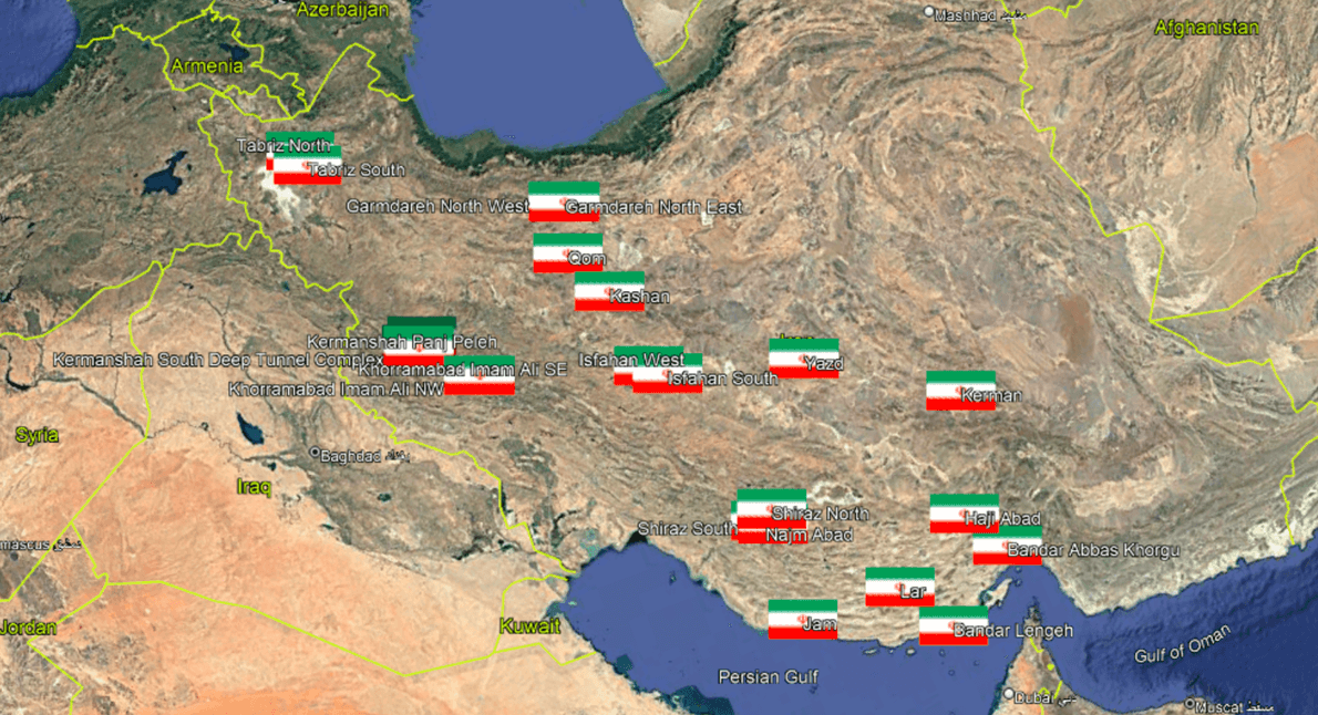
With 25 identified ballistic missile sites spread across Iran, each with multiple silos and garaging for mobile drone and missile launchers, Israel will need every available bomb directed at this Iranian ballistic missile and drone infrastructure to cripple and close down any potential Iranian counter-attack.

 
25 identified Iranian ballistic missile/drone clusters, each with multiple silos and sites (Google Earth)

Nonetheless, Israel regards Iranian leadership of its Axis of Resistance as critical to the effectiveness of the forces attacking Israel on multiple fronts.
If refomists in Iran could supplant religious hardliners who currently dominate the regime and are the driving force behind Iran’s regional expansionism, then Israel might wish to be a catalyst to this process.
In this case, a closure of the Strait of Hormuz might bring about such a change, but it would be a huge gamble to believe that this aim could be achieved without a massive risk to global stability.

Links :

Sunday, June 15, 2025

What’s hiding deep under the ocean?


Explore underwater crime scenes, wine aging, memorial reefs, and mystical caves in this thrilling compilation of ocean exploration stories.
Dive into the depths of the Mediterranean, Yucatan, and beyond, uncovering how the ocean transforms both life and death.
These incredible tales reveal the secrets of the deep.

Saturday, June 14, 2025

Image of the week : biggest wave ever ridden at Jaws

 
Benjamin Sanchis (Hossegor, France) tows into one of the biggest waves ever challenged by a human but fades a bit too deep at Jaws, Maui, Hawaii on December 22, 2024. 
 
Links :