Monday, January 22, 2024

Carbon released by bottom trawling ‘too big to ignore’, says study

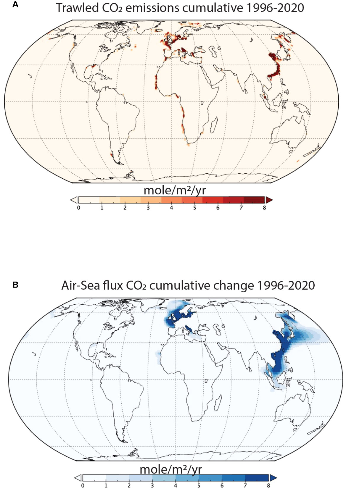
Spatial differences in the historical effects of benthic trawling on CO2 emissions. (A) Cumulative emissions of trawled CO2 between 1996-2020. (B) Cumulative changes in the air-sea CO2 flux due to trawling between 1996-2020.
It is important to note that significant knowledge gaps exist regarding trawling activity in the Arctic Sea (FAO Area 18), Western Central Pacific (FAO Area 71), and the Eastern Indian Ocean (FAO Area 57) (Taconet et al., 2019).
Consequently, emissions attributed to trawling in these regions are likely underestimated.
 
From The Guardian by Karen McVeigh

Fishing nets churn up carbon from the sea floor, more than half of which will eventually be released into the atmosphere

Scientists have long known that bottom trawling – the practice of dragging massive nets along the seabed to catch fish – churns up carbon from the sea floor.
Now, for the first time, researchers have calculated just how much trawling releases into the atmosphere: 370m tonnes of planet-heating carbon dioxide a year – an amount, they say, that is “too big to ignore”.

Over the study period, 1996-2020, they estimated the total carbon dioxide released from trawling to the atmosphere to be 8.5 to 9.2bn tonnes.
The scientists described trawling as “marine deforestation” that causes “irreparable harm” to the climate, society and wildlife.

The study – Atmospheric CO2 emissions and ocean acidification from bottom trawling, written by a global team of climate and ocean experts – found that 55-60% of the carbon dioxide in the water released from the seabed by trawlers will make it to the atmosphere within nine years.

Trawling hotspots in the East China Sea, the Baltic, the North Sea and the Greenland Sea have the largest climate emissions, the study said.
Carbon released from the sea floor also causes local acidification, reducing the oceans’ capacity to absorb carbon, the study found.

“We have long known that dragging heavy fishing nets – some as large as 10 747 jets – across the ocean floor destroys sea life and habitats,” said Dr Trisha Atwood, an aquatic ecologist at Utah State University and National Geographic’s Pristine Seas. 
“Only recently, we have discovered that bottom trawling also unleashes plumes of carbon, which otherwise would be safely stored for millennia in the ocean floor.”

Sediment plumes from commercial trawling, not unlike vapour trails left by aircraft, can be seen from space.

The study relied on a vessel-tracking database processed by Global Fishing Watch, which shows where trawling took place in 1996-2020.
They added data on sea-floor carbon, then used three different internationally accepted models of carbon cycles in the ocean, used by the Intergovernmental Panel on Climate Change, to calculate how much carbon released into the water entered the atmosphere.

“Our study is the very first to show that over half the carbon released by bottom trawling eventually escapes into the atmosphere as CO2 over the span of about 10 years, contributing to global warming,” said Atwood. 
“Much like destroying forests, scraping up the sea floor causes irreparable harm to the climate, society and wildlife.”
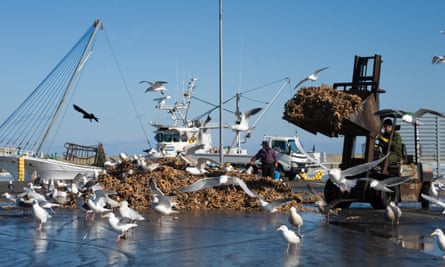
 
Gulls feeding on dead starfish dumped on the quay from fishing trawlers in Hokkaido, Japan.Photograph: Universal/Getty Images


The research builds on previous work by some team members, published in 2021, which showed that bottom trawling released as much carbon dioxide into the ocean annually as the entire aviation industry, but the fate of the carbon in the water remained an unknown.

The new stud, found that the amount released into the air could double the annual emissions from fuel combustion of the entire global fishing fleet of 4m vessels.

Dr Enric Sala, the explorer-in-residence and executive director of Pristine Seas, said the amount of carbon released by trawling into the air, is “too big to ignore” and urged countries to include the emissions in their climate action plans.

“Countries don’t account for bottom trawling’s significant carbon emissions in their climate action plans,” said Sala. “The good news is that reducing bottom trawling carbon emissions will deliver immediate benefits. The bad news is, delaying action ensures that emissions from trawling will continue seeping into the atmosphere a decade from now.”

The magnitude of trawl-induced carbon dioxide released into water in the original 2021 study – published in Nature and led by Sala – was challenged last year by other scientists, writing in the same journal.

Sala – who said the challenge and its conclusions were based on incorrect assumptions, lacked quantitative support and contained larger uncertainty than his own model – stands by the conclusions of the 2021 paper.

“One thing this new paper shows is that, regardless of the amount of carbon released by bottom trawling, over half will go into the atmosphere within a decade,” Sala said.

The estimates of carbon dioxide released to the atmosphere from trawling are conservative, the researchers said, given they have included only trawlers that are publicly tracked, when a Global Fishing Watch study found that 75% of fishing vessels are not.

Links :

Sunday, January 21, 2024

Canada (CHS) layer update in the GeoGarage platform

Country diary: An underwater cathedral with sparkling char and neon-green algae

Silfra Fissure is the only place where you can dive or snorkel directly in the crack between two continental plates and is the clearest water on earth.
Silfra Fissure is located in Thingvellir National Park in Iceland, the Silfra dive site is approximately 60 kilometres (a 45-minute drive) from Reykjavik.
The Silfra fissure, is known as one of the top dive sites in the world for two main reasons.
First, the Silfra fissure is actually a crack between the North American and Eurasian continents, meaning that you dive or snorkel right where the continental plates meet and drift apart about 2cm per year.
Secondly, the underwater visibility in the Silfra fissure is over 100 meters, which creates an underwater experience that will rarely, if ever, be surpassed.
The reasons for this astounding water clarity are twofold: the water is cold (2°C – 4°C year round ) as it is melt water from the nearby Langjökull Glacier and this water is filtered through porous underground lava for 30-100 years until it reaches the north end of Thingvellir lake, seeping out from underground wells.
The Silfra water is as pristine as water can get and you can drink it at anytime during your dive or snorkel.

From The Guardian by Claire Stares


Silfra, Thingvellir national park, Iceland: Life is hard here, but some organisms are finding a way to live in the gin-clear water

Silfra, a rift in the mid-Atlantic Range, is the only place on Earth where it’s possible to snorkel between two tectonic plates.
 
Silfra with the GeoGarage platform (IC-HDG nautical raster chart)
 
Glacial meltwater flows continuously through the fissure, which is situated on the rim of Thingvellir Lake.
Having percolated through volcanic rock, this water is exceptionally pure and gin-clear, with visibility of up to 100 metres.
But as I waded in, immersed my masked face and gazed into the blue abyss, the underwater landscape appeared barren, a labyrinth of rock and boulder piles.
I was clad in layers of thermals, a drysuit and a neoprene hood, but within seconds my exposed lips and cheeks began to sear with cold.
With a constant temperature of between 2-4C, it seemed an inhospitable environment for any organism.


Though biodiversity is limited, Silfra does contain life, most notably Crymostygius thingvallensis, an endemic species of groundwater amphipod crustacean.
Many of the fissure’s other inhabitants are microinvertebrates, invisible to the human eye.
As the current carried me through the Big Crack and into a wider section known as Silfra Hall, I began to notice that the rocks were draped with translucent creamy-beige and reddish-brown biofilm mats, which I discovered were matrices of these imperceptible creatures, cyanobacteria and benthic diatoms (a form of microalgae).
They had the ragged appearance of degrading plastic bags and were dotted here and there with tufts of neon green algae known locally as troll hair.

As I ventured deeper into the fissure, entering Silfra Cathedral, a breathtaking open chamber with soaring lava walls, there was a momentary flash of scales in my peripheral vision.
A 10cm-long, olive-green, speckled-flanked Arctic char (Salvelinus alpinus) darted out of an inky crevice.
In contrast with the UK, where the species is predominantly restricted to upland lakes and lochs, and is at risk of extinction due to acidification, pollution and rising water temperatures, they are the most common and widespread freshwater fish in Iceland.
Thingvellir Lake supports four morphological variants, which have evolved to exploit different ecological niches.
While the benthic, piscivorous and planktivorous char occasionally stray into the fissure during the August to September mating season, the diminutive dwarf morph is the only fish to inhabit it year-round.

Links :

Saturday, January 20, 2024

The History of Cartography, the “Most ambitious overview of map making ever,” is free online


Or what Edward Rothstein, of The New York Times, called “the most ambitious overview of map making ever undertaken.”
He continues:
People come to know the world the way they come to map it—through their perceptions of how its elements are connected and of how they should move among them.
This is precisely what the series is attempting by situating the map at the heart of cultural life and revealing its relationship to society, science, and religion….
It is trying to define a new set of relationships between maps and the physical world that involve more than geometric correspondence.
It is in essence a new map of human attempts to chart the world.

If you head over to this page, you will see links (in the left margin) to five volumes available in a free PDF format.
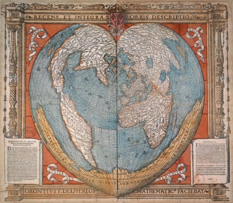
The image above, appearing in Vol. 2, dates back to 1534.
Created by Oronce Fine, the first chair of mathematics in the Collège Royal (aka the Collège de France), the map features the world drawn in the shape of a heart.
A pretty beautiful design.

If you buy any of the printed versions on Amazon, each edition will cost you $400-$500.

Friday, January 19, 2024

America fights back

image: Ricardo Rey

From The Economist

The war against the Houthis is part of an escalating struggle for the seas

Around the world a storm is building on the oceans after decades of calm.
In the Red Sea Houthi militias have launched dozens of attacks on ships with drones and missiles, cutting container activity in the Suez canal by 90%.
On January 12th America and Britain responded with more than 60 sea and air attacks on Houthi targets in Yemen in an attempt to restore open passage, expanding the scope of the Middle East conflict.
President Joe Biden threatened further military action and said America would not allow “hostile actors to imperil freedom of navigation in one of the world’s most critical commercial routes”.

The escalation in the Red Sea is mirrored by maritime mayhem elsewhere.
The Black Sea is filling up with mines and crippled warships; this year Ukraine hopes to eject the Russian navy from Crimea, its base since Catherine the Great.
The Baltic and North seas face a shadow-war of pipeline and cable sabotage.
And Asia is seeing the largest build-up of naval power since the second world war, as China tries to coerce Taiwan into unifying and America seeks to deter a Chinese invasion.
After Taiwan’s election on January 13th, tensions there could soar.

The U.S. Navy is already operating the Triton drone boat near Iran, and more Tritons could soon be used to counter China and other adversaries in the world’s waters.
The autonomous sailboat-turned-submarine can carry various payloads, and since it’s powered by solar panels, it can sail autonomously for months at a time.
Military experts say drones like the Triton could be used for various offensive and defensive purposes, from defending ports and monitoring underwater pipelines to laying sea mines and attacking Navy ships.

These events are not a coincidence, but a sign of a profound shift taking place on the planet’s oceans.
The world economy is still globalised.
Some 80% of trade by volume and 50% by value travels on a fleet of 105,000 container ships, tankers and freight vessels that ply the oceans day and night, taken for granted by the people whose livelihoods depend on them.
Yet superpower rivalry and the decay of global rules and norms mean that geopolitical tensions are deepening.
The inevitable and underappreciated consequence is that oceans are a contested zone for the first time since the cold war.

The quest for opportunity and order at sea has a long history.
In the 17th century Grotius, a Dutch jurist, laid out the principle of freedom of navigation and in the 19th Britain enforced it by means of the Royal Navy and a network of ports and forts.
Open oceans were enshrined in the post-1945 order and, from the 1990s, the maritime world reflected the rise of globalisation and American power.
That emphasised hyper-efficiency and extreme concentration.
Today 62% of containers are carried by five Asian and European firms, 93% of ships are built by China, Japan and South Korea, and 86% are scrapped in Bangladesh, India or Pakistan.
The us Navy’s specialist role has been as the near-monopoly provider of security, using over 280 warships and 340,000 sailors.

This vast and intricate system faces two challenges.
One is fraught geopolitics.
China’s naval build-up means the us Navy’s primacy in the Pacific is being contested for the first time since 1945.
There are more rogue actors.
The Houthis, backed by their sponsor Iran, have proven resistant to attacks from Saudi Arabia and the United Arab Emirates, suggesting that they will not be quickly subdued by the American and British strikes.
As well as the Houthis, landlocked Ethiopia’s dictator is leasing a Red Sea naval base in neighbouring Somaliland.
The law of the sea is in decline.
China ignores tribunal rulings that it objects to.
And the West’s use of sanctions has triggered a smuggling boom: 10% of all tankers are part of an anarchic “dark fleet” operating outside mainstream laws and finance—twice the share of 18 months ago.

The geopolitical winds are being strengthened by technological and climate disruption.
China has invested in anti-ship missiles, pushing us Navy vessels farther offshore.
Arms proliferation means militias like the Houthis now have cruise missiles, a capability that, until recently, only states possessed.
The knowledge economy—and the dominance of Wall Street and Silicon Valley—depend on 600-odd subsea data cables vulnerable to sabotage.
Climate shifts are changing geography and incentives.
The Panama canal is short of water (see Americas section); trade routes are expanding in the Arctic as it melts; and the green-energy boom is catalysing a scramble to mine the seabeds.
 
Disorder therefore looms on the high seas.
One cost will be transient disruptions to commerce.
Seaborne trade is worth about 16% of global gdp.
The shipping system is adaptable but only up to a point.
Single shocks can often be absorbed.
The Houthi attacks have so far caused a spike in insurance and shipping rates, but have not yet led to broader price rises, because the container and energy markets have spare capacity.
But that could easily change.
Oil prices rose on news of the American and British attacks and if the disruption spreads to the Strait of Hormuz, through which much of the world’s oil and gas flows, or if Iran becomes directly involved, they could rise much further.

And when markets are tight or there are synchronous shocks, the penalty can be high.
The post-lockdown shipping crunch in 2021 and the Black Sea grain disruptions in 2022 caused worldwide inflation.
Although shipping is a low share of most products’ final price, unpredictability at sea would lead firms to shrink their supply chains, adding to costs.

Large-scale conflicts at sea could be devastating.
Maritime confrontations have their own distinct qualities, because the difficulty of rapidly reinforcing fleets means that escalation is less likely than on land.
Still, it is easy to identify where conflict could break out.
Attacks by, say, Iran or Russia on pipelines, liquefied-natural-gas routes or data cables could be crippling.
Spats over strategic islands could trigger confrontation in the South China Sea and Indian Ocean (see Asia section).
And embargoes of economies more sophisticated than Russia’s or Iran’s could do enormous damage.
A simulation by Bloomberg shows a blockade of Taiwan and Western countermeasures cutting global gdp by 5%.

All this shows the need to deter rogue actors and hostile states.
Yet there is no easy passage back to the calm waters of the 1990s.
Appeals to uphold universal laws are unlikely to succeed.
Trade-dependent China has much to lose, but wants to subvert Western sanctions and pursue illegal claims in the South China Sea.
It does not help that America has not ratified the main global treaty on maritime law.
Nor can the West quickly re-establish its naval dominance after chronic underinvestment.
With a puny 5% of global shipyard capacity, it will need decades to rebuild its fleets.
 

The Red Sea is one of the most important shipping waterways in the world, but the Israel-Hamas War has helped it also become one of the most dangerous.
The Bab-el Mandeb Strait, or the Gate of Tears, is a vital passageway for ships traveling through the Suez Canal, but recent attacks from Houthis are creating a major maritime choke point.
WSJ explains how the cargo industry is responding to try and guard against attacks from the Houthis in Yemen.
0:00 The Gate of Tears
0:54 Houthi attacks in Yemen
2:33 Defending against attacks
3:11 What’s next?
 
Dead calm

A different response is needed.
Western countries must double-down on maintaining their technological edge, in submarines and autonomous vessels, for example.
Government and private-sector co-operation in monitoring vulnerable maritime infrastructure such as pipelines is critical, as are sea-based and satellite backups for data cables.

And alliances need to be broadened in order to make more resources available for policing the seas.
America is rebuilding its Asian naval pacts and the emerging response to the Houthis in the Red Sea could ultimately provide a model.
While America and Britain launched the latest strikes on the Houthis, four other countries provided military support, and a much larger cast of navies, including those of Asian states, are now active in the Red Sea.
Because of the stakes, sustaining a maritime order is the lowest common denominator of international co-operation.
It is something that even isolationists should subscribe to.
Without it, the world economy would be sunk.
 
Links :