From YachtingMonthly by Pete Goss
Many of us will have run aground at some point in our sailing life. Pete Goss examines intentional and accidental going aground and the best methods for getting off
Going aground, I suspect,is far more common than we think.
Many of us will have run aground at some point in our sailing life. Pete Goss examines intentional and accidental going aground and the best methods for getting off
Going aground, I suspect,is far more common than we think.
It’s one of those things that falls into the category where the measure isn’t the cock-up itself but the number of people that witness it.
Often private affairs, groundings are kept safely tucked away in the sheepish pen.
Often private affairs, groundings are kept safely tucked away in the sheepish pen.
This is such a shame as lessons and reminders not being broadcast can fan further incidents.
In this article I will share some personal reflections and anecdotal incidents to open up the subject of grounding and hopefully stir an awareness of how to prepare or react.
It is a huge subject that could fill an entire book so my hope is that the touch points I examine and discuss here will encourage further reflection and the introduction of routines that can be drawn down with immediate effect.
In this article I will share some personal reflections and anecdotal incidents to open up the subject of grounding and hopefully stir an awareness of how to prepare or react.
It is a huge subject that could fill an entire book so my hope is that the touch points I examine and discuss here will encourage further reflection and the introduction of routines that can be drawn down with immediate effect.
Going aground intentionally
In areas that dry out, grounding, rather than being a dirty word becomes a daily reality.
This is where many lessons can be learned with the biggest influence being boat choice.
Bilge keels, lifting keels, centre boarders, legs and cradles.
Bilge keels, lifting keels, centre boarders, legs and cradles.
My personal preference is the centre board because it can act as a sounding stick that simply pivots without serious impact on grounding.

Going aground happens to us all.
Being alert to the dangers and ready to respond is critical to how we fare when the inevitable happens.
Photo: Ben Sutcliffe-Davies
Centre boarders have the additional benefit of fixed ballast to fully maintain righting moment, even with the board up.
Unlike bilge keelers, good windward performance is maintained and the hull is low down for boarding when dried out.
This for me is the answer which leaves a fin keel if you are dead set on windward performance.
This for me is the answer which leaves a fin keel if you are dead set on windward performance.
The best solution I have seen for drying out a fin-keeled boat on a regular basis is a cradle, of which there are good examples in Looe Harbour.
Against a wall
Beyond day-to-day berthing, reasons for drying out range from scrubbing the bottom, changing anodes, checking impellers and rudders, or sheltering from a storm.
To dry out a fin-keeled boat, it’s best to find a good wall to dry out against and locals will point you in the right direction.
I always check the site at low water to ensure the bottom is suitable and to measure the hull contact point for any obstructions in the wall.
This will also indicate whether a ladder will be required to access the coach roof once dried out.
At the same time I will put a position mark on the wall where the shrouds should line up.
At the same time I will put a position mark on the wall where the shrouds should line up.
Don’t forget to drain the water tanks to reduce weight and place movable ballast such as the anchor, life raft and sails towards the inner side deck to encourage a heel towards the wall.

Check at low tide before drying out a fin keeler.
Photo: Theo Stocker
A spinnaker halyard made ashore is essential.
A plank outside the fenders protects against a rough and uneven wall.
To avoid point loading the hull, I have round fenders to fill the widening gap as the hull curves away from the wall.
Bilge-keels
Bilge-keelers require a flat surface with easy access to the shore, preferably avoiding mud, which spreads like nothing else.
As an aside we had a Prout Snowgoose as a family banger which we continuously dried out, necessitating a hardwood shoe to protect the glass keels.
Most lifting-keel and centre-board craft settle bow-down, so I like to find a suitable incline to level the boat.
Most lifting-keel and centre-board craft settle bow-down, so I like to find a suitable incline to level the boat.
The most important thing here is to ensure that you’re made fast to the shore with the addition of a couple of anchors out to sea.
One of these should be much further out than the other so that you can raise the first and then use the last to drag yourself well offshore.
One of these should be much further out than the other so that you can raise the first and then use the last to drag yourself well offshore.
If the engine fails, this offers sufficient room to drop it again.
On this note, pay attention to the forecast – the wind might not be in quite the same direction when you re-float.
In a similar vein, pay close attention to the swell forecast; I’ve known big swells arrive out of a perfectly calm blue day which can work their influence well inland.
I always call the local harbour master to check for the possibility of wake.
In a similar vein, pay close attention to the swell forecast; I’ve known big swells arrive out of a perfectly calm blue day which can work their influence well inland.
I always call the local harbour master to check for the possibility of wake.
I remember a yacht that was just about to float outside a French fishing port when a rush of trawlers headed out at full throttle for the morning catch.
It was awful to watch as the boat bashed away for an hour.
The trawlers, despite being called on VHF and waved down from a dinghy couldn’t give a monkeys.
It’s worth noting here that the worst kind of impact for a keel is vertical shock loads with the boat dropped onto the seabed by waves.
It’s worth noting here that the worst kind of impact for a keel is vertical shock loads with the boat dropped onto the seabed by waves.
The loads drive straight up into the structure with nothing to dissipate the impact, such as the bow dipping down when hitting the bottom when under way.
The result is often catastrophic.

Looe Harbour in Cornwall has cradles for fin keelers to take the ground
This happened to a friend of ours and was exacerbated by a deep rudder that also hit the bottom to take out the rudder bearings.
We’ve resolved this on our new boat with lifting rudders.
Storm protection
There are many reasons for drying out, from maintenance to simply enjoying the upper reaches of a river or creek.
One that is rare but should be kept in mind is storm protection.
In hurricane areas there is nothing like a mangrove swamp to dissipate waves and offer lots of secure points to which you can make fast.
Some of our big UK depressions warrant hiding away and our estuaries are littered with handy little mud creeks to nose into.
In hurricane areas there is nothing like a mangrove swamp to dissipate waves and offer lots of secure points to which you can make fast.
Some of our big UK depressions warrant hiding away and our estuaries are littered with handy little mud creeks to nose into.
One thing I would warn against is being stranded above the high water mark by a storm surge.
I have recced a few spots along the south coast that would suit our boat should a hundred-year storm show its face.
I have recced a few spots along the south coast that would suit our boat should a hundred-year storm show its face.
Sheltered from wind in all directions, out of the main channel where flooding rain water can generate strong currents, beyond falling trees and with plenty of strong points to which you can moor.
Going aground unintentionally
While it may be obvious that avoiding grounding in the first place is covered by the practice of good seamanship, within that catch all phrase, I think it worth highlighting a few pointers that I have found to be helpful.
Navigation is key and talking to a number of insurance companies a common suggestion is to carry paper charts.
I wouldn’t put to sea without an electronic chartplotter – they are wonderful – but I still treat them as an aid to traditional methods.
True, we spend a lot on charts but I wouldn’t be without them and evidence would back this up.
You only have to study the Team Vestas Wind disaster during the Volvo Ocean Race to see the hidden risks that come with electronic charts.
You only have to study the Team Vestas Wind disaster during the Volvo Ocean Race to see the hidden risks that come with electronic charts.
Here was a top line boat filled with some of the best sailors and navigators in the world and yet they sailed straight into a reef at full speed.
It beggars belief until you dig a bit to realise ‘there but the grace of God go I’.
I always ask ‘What would I do if our power went down?’ and so I carry everything required including a Walkers towed log.
Planning risk
When passage planning I mentally project a colour-coded risk assessment across the plan.
This visual reference highlights areas that require extra concentration, as it is so easy, particularly when tired, to creep into a vulnerable area without realising.
In really dodgy areas I’ll actually pencil a boundary that, when crossed, must prompt a higher state of alertness with the skipper on deck, a crew briefing and the implementation of appropriate procedures such as a crew member at the bow, kedge anchor rigged and dinghy launched.
In really dodgy areas I’ll actually pencil a boundary that, when crossed, must prompt a higher state of alertness with the skipper on deck, a crew briefing and the implementation of appropriate procedures such as a crew member at the bow, kedge anchor rigged and dinghy launched.
It can also include areas of no-go in darkness.
Red areas require the passage plan to be checked after a night’s sleep.
The overriding rule of thumb is to listen to your instinct, ‘if in doubt stay out’.
The overriding rule of thumb is to listen to your instinct, ‘if in doubt stay out’.
Navigational error
It’s essential to keep a regular log recording barometric pressure, wind direction and position.
An hourly plot on my chart provides a helicopter view and often highlights hazards that can be hidden by layering on a chart plotter.

Some shallow harbours and anchorages are worth taking a calculated risk to reach.
Photo: Pete Goss
Use of a simple handheld compass is a terrific and easy way of checking things.
I lay off an approach bearing and use the main compass to check things are lining up as they should.
This practice came from a cruise in the Baltic when we arrived soon after a late thaw thanks to a delayed spring.
Making down the centre of a perfectly buoyed channel towards a marina we were shocked to run hard aground.
Making down the centre of a perfectly buoyed channel towards a marina we were shocked to run hard aground.
Fortunately it was soft mud and we were able to reverse out on a rising tide.
It wasn’t until I took a bearing that we realised the winter ice had shifted the markers to the east a hundred metres before perfectly re-laying them as the ice thawed.
It wasn’t until I took a bearing that we realised the winter ice had shifted the markers to the east a hundred metres before perfectly re-laying them as the ice thawed.
On the hard was a yacht that had suffered the same fate at six knots on a falling tide.
Out of desperation they decided to drive back into the channel through the mud with the helm hard over and engine revs at full power.
When they discovered this wasn’t enough they got the harbour master to tow at 90º off the bow and collectively generated enough torque to tear the hull away from the keel.
If ever there was a lesson in the fragility of both navigational aids and of a yacht’s structure being asked to withstand that for which it wasn’t designed, then here it was.
This fragility was later underlined as I made a night approach in bad conditions to an unknown harbour. I was grubbing around searching through the mist and sheeting rain, stopwatch in hand, for a light flashing three in 10.
If ever there was a lesson in the fragility of both navigational aids and of a yacht’s structure being asked to withstand that for which it wasn’t designed, then here it was.
This fragility was later underlined as I made a night approach in bad conditions to an unknown harbour. I was grubbing around searching through the mist and sheeting rain, stopwatch in hand, for a light flashing three in 10.
To my great relief it popped up in a lull and was confirmed by the stopwatch.
Shortly afterwards I noticed surf under the bow and just managed to turn back to sea, heart in mouth.
Shortly afterwards I noticed surf under the bow and just managed to turn back to sea, heart in mouth.
It turned out that three cars, with a fourth following
10 seconds later, had driven round a tight bend.
10 seconds later, had driven round a tight bend.
I saw what I wanted to see and nearly lost a yacht.

Once aground, protecting the boat from further damage is the main consideration.
Photo: Nigel Calder
The first example underlines the benefit of traditional skills, and the second the benefit of a chart plotter.
Taking risk
There are times, under the right circumstances, that warrant taking on a greater risk of grounding.
There are times, under the right circumstances, that warrant taking on a greater risk of grounding.
There are some amazing shallow anchorages and passages that are a bit close to the bone.
I have used a drone to tease out a passage through a narrow rock-strewn inlet in Maine. At low water I’ve set my own withies using branches.
I have used a drone to tease out a passage through a narrow rock-strewn inlet in Maine. At low water I’ve set my own withies using branches.
In the Scilly Isles I’ve walked a tidal passage using a handheld GPS to provide waypoints for the plotter.
In the right circumstances and conditions these are fun and rewarding exercises.
Other causes Common causes of groundings beyond navigational error are loss of power, loss of steerage, dragging the anchor and swinging into shallows.
Other causes Common causes of groundings beyond navigational error are loss of power, loss of steerage, dragging the anchor and swinging into shallows.
Solutions should be thought through from emergency steering to auxiliary power.
On our Garcia Exploration 45, Pearl of Penzance, we could drop the dinghy outboard onto the transom. In the case of our new boat, Oddity, we have two lifting rudders to avoid damage and offer complete redundancy.
On our Garcia Exploration 45, Pearl of Penzance, we could drop the dinghy outboard onto the transom. In the case of our new boat, Oddity, we have two lifting rudders to avoid damage and offer complete redundancy.

Many estuaries offer deeper pools across shallow bars. Anchor off and inspect by dinghy first if you are unsure.
Photo: Nigel Calder
Make sure you have a well-serviced engine with a dedicated and annually-tested start battery.
Years of happy sailing breeds complacency and, if not prepared, circumstances can quickly escalate.
We had a huge lump of fishing net stop our engine dead as we rounded a particularly dodgy headland in southern Brittany.
We had a huge lump of fishing net stop our engine dead as we rounded a particularly dodgy headland in southern Brittany.
We were an hour behind schedule and the tide was carrying us onto the rocks.
Fortunately I had left plenty of sea room, my mask, snorkel, fins and knife were ready and I was over the side in a flash.
A close call, with preparation saving the day.
Harbourmasters are always sweeping up boats after a storm and, from my time spent working on the tugs in Plymouth, the majority could have been avoided with better maintenance of ground tackle below and improved chafe protection above.
Harbourmasters are always sweeping up boats after a storm and, from my time spent working on the tugs in Plymouth, the majority could have been avoided with better maintenance of ground tackle below and improved chafe protection above.
If you are expecting a gale or leaving the boat for a long period then shackle your anchor chain to the mooring.
Unintentional Groundings – Response
Should you go to ground under way or at speed, crew safety comes first, followed by extraction from the situation.
Check the crew; a common injury of a dead stop is broken ribs.
I always sleep feet forward to save my neck. MOB is also common so a quick crew count is imperative followed by donning life jackets.
Check the keel bolts and keel matrix for damage and bilges for water, taste it in case the issue is ruptured water tanks.
Check the keel bolts and keel matrix for damage and bilges for water, taste it in case the issue is ruptured water tanks.
Check the bulkheads, looking for crazed gelcoat.
Be thorough, as shock loads can travel to odd places before delivering their final destructive blow.
Check the engine mounts before powering up the engine and slowly build the revs feeling for unusual vibrations.
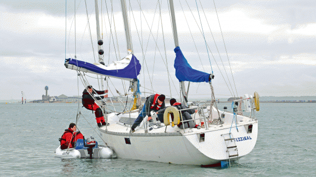
Do not be tempted to put crew in a vulnerable position.
Lifting a laden dinghy will be far more effective in getting the boat to heel and reduce the keel’s draught.
Photo: Lester McCarthy/YM
It’s common for the rig to be damaged so whip round the chain plates, scan the rig with binoculars and give it a good shake.
If you’re not stuck fast, make for calm waters as soon as possible to reduce keel loads.
In a seaway raise the main to steady the boat and avoid wrenching the keel about.
In a seaway raise the main to steady the boat and avoid wrenching the keel about.
After any grounding, no matter how soft, the boat must be lifted for a thorough check of the hull, keel and rudder.
Most insurance policies will cover the lift and survey, whether there is damage or not.
Most insurance policies will cover the lift and survey, whether there is damage or not.
If you track back from a lot of keel losses there will often be an un-checked grounding hiding in its past.

If any work boats are available locally, their extra weight and horsepower might help pull you off. Photo: Graham Snook/YM
During the Three Peaks race we bounced on the bar at Ravenglass and during a later gale found that the keel box had started to separate from the hull.
Every time we came off a wave the box moved and sprayed water across the cabin.
We had done a thorough ‘on the ground inspection’ but on reflection we should have retired and lifted her.
If chartering I dive on the keel to check for surface damage and insist on a lift out if needs be.
If chartering I dive on the keel to check for surface damage and insist on a lift out if needs be.
It’s just not worth the risk.
Falling tide
It’s not until you have gone aground on a falling tide that you realise how quickly the levels fall.
It’s horrifying; there’s no time to think and barely enough to act.
Routines need to be in place with equipment to hand for immediate deployment.
Check the tide; if you’re lucky and it’s rising, put all the crew on the bow and try to back off. Launch the dinghy to circle the boat with a lead line to establish the best escape route.
Check the tide; if you’re lucky and it’s rising, put all the crew on the bow and try to back off. Launch the dinghy to circle the boat with a lead line to establish the best escape route.
I am told there are very good hand-held echo sounders but have no experience of them.
Top up the kettle before running the fresh water tap to clear the tanks.
Top up the kettle before running the fresh water tap to clear the tanks.
Heel the boat
If the above doesn’t work, heel the boat.
Putting people on the boom makes them vulnerable and has limited effect, so hitch up the dinghy to the spinnaker halyard, chuck in sails, kedge anchor, crew and any easily-moved equipment.
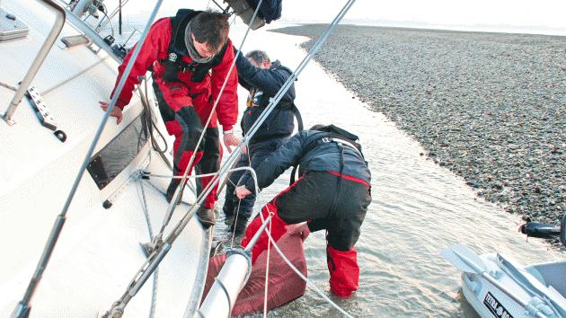
Use whatever is to hand to protect the hull from rough ground.
Photo: Kieran Flatt/YM
I set the spinnaker pole out with a guy fore and aft to stabilise it.
The halyard is then run though a bowline on a rope that returns inboard through the pole end.
Once the boat has heeled enough for gravity to take the halyard beyond the radius of the pole the line can be released.
Make sure the dinghy fastenings can take the load or, in the case of an inflatable, have webbing strops.
Make sure the dinghy fastenings can take the load or, in the case of an inflatable, have webbing strops.
Once the boat is heeled try and motor off but be aware that the engine might not be picking up as much oil from the sump as it should.
All this must be done in the blink of an eye so practise it and have it already set up if you suspect you might be caught out.
All this must be done in the blink of an eye so practise it and have it already set up if you suspect you might be caught out.
Get people to assist
In the Bahamas, we helped a yacht off a bar with 10 dinghies and a fishing boat off the spinnaker halyard.
The fishing boat pulled the guard rails under whilst the rest of us pushed in the direction we wanted the boat to go.
All pretty agricultural but it saved the boat thanks to a clear plan and some forthright leadership to create a cohesive effort and quell a thousand daft ideas.
All pretty agricultural but it saved the boat thanks to a clear plan and some forthright leadership to create a cohesive effort and quell a thousand daft ideas.

1Shock loads can travel and dissipate in hidden corners, such as the keel matrix bonding, or bonded-in bulkheads, as above.
Photo: Nigel Calder
Staying put
If you can’t get off accept it and swiftly move into phase two.
As Einstein said, ‘stupidity is repeating the same action and expecting a different outcome’.
Radio the authorities, heel the boat up the incline – a kedge anchor off the spinnaker halyard is good for this.
Radio the authorities, heel the boat up the incline – a kedge anchor off the spinnaker halyard is good for this.
It might sound daft but I always contact the designer to make sure that hatches will remain above the water as the tide rises.
If this is not the case, carry hatch boards and some tubes of silicone.
Lighten the boat by taking gear ashore.
Lighten the boat by taking gear ashore.
Lay out anchors so the incoming tide doesn’t carry the boat further inshore.
Put ropes under the hull so that you can secure fenders from both top and bottom at the point of contact.
It might sound drastic but if the ground is rough, utilise sails, cushions and locker lids or internal doors. You’ve just gotta do what you gotta do; I have a friend who walked ashore, borrowed shovels from a farmer and spent six hours digging a channel between the hull and deeper water to great effect.
It might sound drastic but if the ground is rough, utilise sails, cushions and locker lids or internal doors. You’ve just gotta do what you gotta do; I have a friend who walked ashore, borrowed shovels from a farmer and spent six hours digging a channel between the hull and deeper water to great effect.
Call for help
The rule of thumb is to expend as much energy into getting afloat as the tide allows.
Success can rest on the smallest detail and it’s too late if you ‘just don’t quite make it’.
If none of the above works then it’s time for phase three which necessitates dispassionate assessment. Is a Pan Pan or Mayday appropriate?
If none of the above works then it’s time for phase three which necessitates dispassionate assessment. Is a Pan Pan or Mayday appropriate?
Call the insurers, maintain the log and take pictures.
Call the authorities for support in extracting the crew, salvaging equipment and removing environmentally hazardous materials such as fuel and gas.
Discuss drastic measures such as the RNLI or a trawler simply dragging her off. In dire straits you might require a helicopter as in the Scillies with Storm Evert.
Discuss drastic measures such as the RNLI or a trawler simply dragging her off. In dire straits you might require a helicopter as in the Scillies with Storm Evert.
In remote areas you might be stranded for a while so consider communications, food, shelter and warmth ashore.
Links :
- GeoGarage blog : Polish captain ran his ship aground as he tried to sail from ... / Italy cruise ship Costa Concordia aground near Giglio / Large bulk carrier grounds in Mauritius / How a Russian vessel's grounding highlights perils of Arctic ... / The grounding and sinking of MV 'Minna' / Old charts may have grounded sub / Kiwi yacht owner blames outdated charts for Fiji shipwreck /
Grounding: achieving the right mix of visual and ... / Chemical tanker grounding and ENC data accuracy / Possible reasons identified for Rena grounding ...