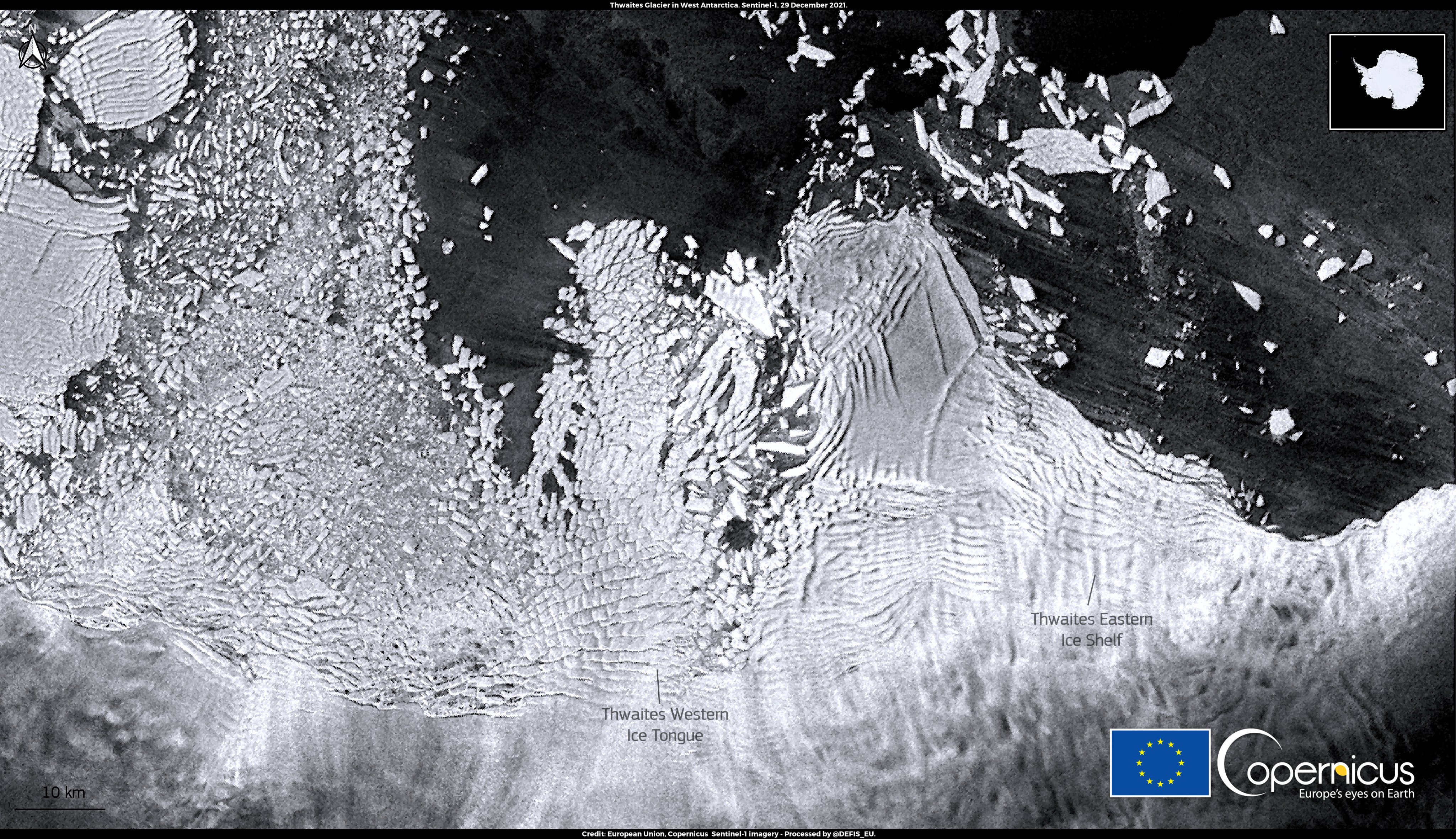
I came face to face with the Doomsday Glacier (a.k.a. Thwaites glacier) in 2019, on a trip to Antarctica aboard the Nathaniel B. Palmer, a 308-foot-long icebreaker operated by the National Science Foundation.
I had dubbed the Florida-sized slab of ice its nickname in an article I’d written a few years earlier, and the name stuck.
Nevertheless, I was unprepared for how spooky it would be to actually confront the 100-foot-tall wall of ice from the deck of a ship.
Locked up here in the West Antarctic ice sheet was enough water to raise global sea levels nearly 10 feet.
As I wrote in a dispatch from Antarctica on the day we encountered Thwaites, it was both terrifying and thrilling to know that our future is written in this craggy, luminous continent of ice.
Our world is heating up fast.
And as every kid knows, on hot days, ice melts.
The question is how quickly.
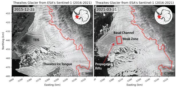
At Thwaites, the melting is mostly a result of warm ocean water attacking it from below, which is stressing and fracturing both the ice shelf that protects the glacier and the glacier itself.
Just how fast Thwaites and the other big glaciers that make up the West Antarctic ice sheet will all fall apart is one of the most important scientific questions of our time.
And it is a question upon which the future of virtually every coastal city in the world depends.
“We know there are tipping points in Antarctic ice sheets, and we also know that Antarctica is the biggest wildcard in the future sea level rise projections,” says Andrea Dutton, a professor of geology at the University of Wisconsin-Madison and a 2019 MacArthur Fellow.
“Basically, it all comes down to ‘when will we reach that tipping point?’ ”
Last week, two new papers were published simultaneously in the science journal Nature that offer radically different visions of the Doomsday glacier, as well as radically different visions of how climate models work and what they can tell us about the future.
But they agree on one thing: “Both papers make it very clear that human decisions are important, and that limiting warming can limit sea level rise,” says Richard Alley, a glaciologist at Penn State and one of the most respected ice scientists in the world.
But beyond that, the two papers may as well be describing life on different planets.
The first paper might be called the Holy Shit vision of Antarctica’s future.
In this scenario, led by Rob DeConto, a climate modeler at the University of Massachusetts-Amherst (Dutton and Alley and 10 other scientists are co-authors), the West Antarctic ice sheet remains fairly stable as long as warming stays below 2 C, which is the temperature threshold identified in the Paris climate agreement.
Beyond 2 C, however, all hell breaks loose.
Thwaites begins to fall into the sea like a line of dominoes pushed off a table and soon takes the rest of the West Antarctic ice sheet with it.
And once the collapse begins, it will be impossible to stop – at least on any human time scale.
In a century or so, global sea levels could rise 10 feet, which would swamp much of South Florida and Bangladesh and many other low-lying regions of the world.
In fact, it could happen even faster than that, says Alley: “We just don’t know what the upper boundary is for how fast this can happen.
We are dealing with an event that no human has ever witnessed before.
We have no analogue for this.” All in all, the paper makes a very strong argument that cutting emissions today may avert a centuries-long climate catastrophe.
DeConto’s paper also warns against betting on a quick techno-fix like CO2 removal.
Unless it is widely deployed by 2070, which, the way things are going, is highly unlikely given the cost and scale-up of the technology that is required, it will be too late.
The second paper might be called the What, Me Worry? vision of Antarctica’s future.
Unlike the DeConto study, which is based on a single model, the second paper, which was led by Tamsin Edwards, a climate scientist at King’s College London, involved 84 people working at 62 institutes in 15 countries.
Edwards and her co-authors use an “emulation” technique to compare the outcome of the different climate models, making the results less dependent on assumptions built into any one scenario, creating what amounts to a statistical average of climate-model outcomes.
In this study, the Doomsday glacier isn’t very doom-y at all.
There’s no collapse, no tipping point, no big jumps in sea level rise.
In fact, although the paper makes clear that the rate of CO2 emissions over the next few decades is clearly important, the difference in global sea level rise from the melting of all land glaciers, not just Thwaites, only differs by 4 ½ inches between a 1.5 C global temperature rise and a 3 C temperature rise (which is a little above where we are headed with current commitments under the Paris agreement).
And much of that comes from increased melt in Greenland and mountain glaciers.
As for Antarctica, the paper says explicitly: “No clear dependence on emissions scenario emerges for Antarctica.” Or as Alley put it to me, a tone of mild astonishment in his voice: “For Antarctica, the Edwards paper basically says, Antarctica doesn’t matter to us and our decisions don’t matter to Antarctica.”
So let me roughly sum up where we are with our scientific understanding of sea level rise risk from Antarctica after more than three decades of serious climate change research: One study tells us that if we don’t cut CO2 emissions fast we will condemn the world to a century of rising seas that will flood every major coastal city and reshape the global map.
The other study tells us that the likely difference between dramatically cutting CO2 emissions and cruising along on the current path is 4 ½ inches of water.
That means more coastal flooding, more erosion, more salt-water intrusion into drinking wells, but it’s a long way from Waterworld.
What to make of all this? Well, for one thing, the discrepancy between the papers demonstrates not only how little scientists really understand about what is going on in Antarctica, but also what a low priority our society has put on funding research to better understand it.
For another, modeling ice sheets is just plain hard, in part because it requires high-resolution models, and in part because a lot of the important events in the story of ice happened 20,000 years ago (or more), for which data is sparse.
Finally, there is a big difference in perspective between the two studies: The Edwards paper only looks at sea level rise out to 2100, whereas the DeConto paper stretches out to 2300.
Even in the DeConto paper, Antarctica doesn’t really start to fall apart until 2120 or so.
As always, what you see depends on the lens you look through.
There’s also the question of how additional snowfall from a warmer atmosphere may offset some or all of the melting from warmer ocean water.
(Warmer air holds more moisture, and thus can result in more snow.) As Edwards tells me via email, “We are not yet sure how much we have control over Antarctica, because snowfall has a counteracting effect that may also increase in future.”
The most important distinction, however, is that the DeConto paper includes a mechanism called Marine Ice Cliff Instability, or MICI (scientists pronounce it “Mickey,” like the mouse) and the Edwards paper doesn’t.
MICI is best understood as a hypothesis about how ice sheets behave in a rapidly warming world.
The gist of it is that, in some conditions, ice sheets don’t simply melt — they collapse.
Warm ocean water can get beneath the glaciers, causing them to fracture and destabilize.
When the ice shelves that keep the glaciers wedged in place break up, the glaciers themselves become vulnerable.
According to the MICI hypothesis, ice cliffs above about 100 meters high or so don’t have the structural integrity to stand on their own, and without ice shelves to buttress them, they will collapse, or calve, into the sea (there’s a more detailed explanation of MICI in my 2017 article on the Doomsday Glacier).
This is more or less what’s happening right now at a few glaciers in Greenland, including Jakobshaven, the fastest flowing glacier in the world.
A few years ago, I flew across the front of Jakobshaven in a helicopter and watched huge chunks of ice calve into the water, creating an army of icebergs that float out into Glacier Bay, where climate-catastrophe tourists take pictures of them and post them to their Instagram accounts.
The calving front at Thwaites is roughly 10 times bigger than Jakobshaven.
If Thwaites’ ice shelf breaks up and starts behaving like Jakobshaven, a whole lotta real estate is gonna get wet real fast.
MICI may be a radical idea, but it is not new.
It has been around since at least the 1960s, when climate scientist John Mercer first traveled to Antarctica and realized that the land beneath the ice in West Antarctica was shaped like a bowl, which means that if warm water got under the ice and began to destabilize the glacier, it could trigger a runaway retreat that could dump a lot of ice into the Southern Ocean very quickly.
Richard Alley took up the idea in the early 2000s, understanding it could be a mechanism to explain why sea levels were so high during the Pliocene era, 3 million years ago, when levels of CO2 in the atmosphere were about the same as they are today.
In 2016, DeConto co-authored a paper with Dave Pollard, a climate modeler at Penn State, that modeled the implications of MICI in Antarctica for the first time.
The paper added more than three feet to sea level rise projections and scared the bejesus out of climate scientists everywhere.
The MICI hypothesis also prompted the formation of the International Thwaites Glacier Collaboration, a five year-long, $50 million joint research effort between the U.S.
and the U.K., which began in 2018 (my trip to Thwaites in 2019 was with scientists participating in this joint research venture).
Among the key questions scientists are asking: How much warm water is getting under Thwaites ice shelf? (Quite a bit, according to a new paper by Swedish oceanographer Anna Wåhlin, which is based on measurements she made while we were in Antarctica together.) How quickly is the glacier losing its grip on the bedrock near the current ice front? How quickly is the ice shelf breaking up?
“In the last few years, we have seen a lot of dynamic change at Thwaites and other glaciers in the region,” says Robert Larter, a geophysicist with the British Antarctic Survey who was the chief scientist on the Palmer on my trip to Antarctica.
According to one recent study, the net ice-mass loss from Thwaites and nearby glaciers is now more than six times what it was 30 years ago, which Larter calls “mind-boggling.”
None of this research is conclusive, and most of it is still too new in include in climate models.
For the moment, MICI remains an outlier idea, one that mainstream climate modelers have yet to fully embrace, despite the risks that civilization faces from it.
“If you want to be generous,” Alley tells me, “You could say that climate modelers really want to make their models carefully, make sure they are calibrated precisely, and they don’t know what to do with MICI.”
“The reason nobody is rushing off an unstable marine cliff in search of what DeConto and Pollard have done is because nobody thinks there is any good reason to single out MICI and make it the cause of instability in glaciers,” says Gavin Schmidt, a climate modeler and director of the NASA Goddard Institute for Space Studies in New York.
“Is MICI a large part of why glaciers calve? It’s not inconceivable, but it’s also not inconceivable that it could be other factors.”
Finally, some of the resistance to MICI may simply be a failure of imagination.
No human has ever witnessed the rapid collapse of a glacier in Antarctica like Thwaites; ergo, it can’t happen.
Alley himself thinks about it simply in terms of risk.
“Maybe we’ll get lucky and the ice cliffs won’t disintegrate in Antarctica quite as fast as we predict,” he says.
“But if you are even a little bit worried that scientists might have made mistakes in their calculations about what is going on in Antarctica, then maybe we should pay attention to this.”
He compares Thwaites and other glaciers in West Antarctica with drunk drivers.
“They are out there, they are scary, and they don’t behave as you expect them to,” Alley says.
“That’s why it’s a good idea to have a seatbelt in your cars.”
In the end, climate modelers are a little like sci-fi writers.
They use facts and physics to spin out possible futures.
DeConto’s paper imagines we are moving into a new world that will behave very differently from the world we have lived in so far.
Edwards’ paper imagines that the rest of the 21st century will look pretty much like it does today, only hotter, and with a little less ice.
Both visions are based in science.
Both visions are plausible.
And both visions are fraught with deep uncertainty about where we are going.
I hope we live in Edwards’ world, but I fear we live in DeConto’s.
- Meteorological Tech Int. : Underwater robots to examine Thwaites Glacier’s impact on sea level rise
- Wired : How Explosives, a Robot, and a Sled Expose a Doomsday Glacier
- Gizmodo : Boaty McBoatface Prepares to Dive Under Antarctica's Doomsday Glacier
- Rolling Stone : ‘The Fuse Has Been Blown,’ and the Doomsday Glacier Is Coming for Us All
- The Conversation : Antarctica’s ‘doomsday’ glacier: how its collapse could trigger global floods and swallow island
- GeoGarage blog : Thwaites: 'Doomsday Glacier' vulnerability seen in new maps / Unprecedented data confirms that Antarctica’s most dangerous glacier is melting from below