Monday, March 18, 2013

How Arctic ice may have influenced superstorm Sandy

A striking image of Verrazano Bridge in Brooklyn as Hurricane Sandy approaches on Oct. 29, 2012.
CREDIT: Carlos Ayala

From OurAmazingPlanet

The sea ice covering the Arctic Ocean may not seem to be connected to a hurricane like Superstorm Sandy, but a group of scientists is suggesting the record lack of ice last summer could have set up the atmospheric pattern that sent Sandy barreling into the Northeast.

The potential link is just one of many ways that human activities can, and in some cases already seem to be affecting Earth's weather and driving it toward extremes, be they droughts, megafloods or superstorms like Sandy.

"Extreme weather of all sorts has been increasing around the Northern Hemisphere.
When Sandy hit such a high-impact and vulnerable part of the East Coast, many reporters and local people have asked us whether climate change played a role," said Jennifer Francis of Rutgers University in New Jersey, one of the scientists who looked at the link. "It's the question on everyone's mind."

Sandy's start

Sandy began its life as a "classic late-season hurricane" over the Caribbean in mid-October, as the National Hurricane Center put it in its summary of the storm.
It tore across Haiti, Jamaica, Cuba and the Bahamas, killing at least 67 people and causing enormous damage.

While Sandy weakened over the Bahamas, it also ballooned in size, giving its wind field an enormous footprint; then, like many storms that form when and where it did, it curved northward, paralleling the U.S. East Coast, driven by the prevailing currents in the atmosphere.
As it skirted the coast, moving over the warm waters of the Gulf Stream, it also regained strength. [On the Ground: Hurricane Sandy in Images]

The storm weakened again as it moved farther north over colder waters, but never lost its extreme size. And as it continued on its path, a mass of high-pressure air sitting over Greenland kept it from simply curving out to sea.
Not only that, noted Francis and her colleagues in their article, but it also caused the storm to do "something never observed before in records going back to 1851 — it took a sharp turn to the west and toward the most populated area along the eastern seaboard."

That's where the Arctic sea ice comes in.


Sea ice and Sandy

The extent of sea ice covering the Arctic waxes and wanes with the seasons, reaching its high point near the end of the Northern Hemisphere winter, and its low point near the end of summer.
But as Earth's average temperature has risen with global warming, the Arctic has been warming at two to three times the rate of the rest of the globe, Francis explained.
This accelerated Arctic warming has fueled ice melt beyond normal summertime levels, which reinforces the warming because open ocean waters absorb the sun's rays, while ice reflects it.

As the Arctic warms, the temperature difference between the poles and lower latitudes is reduced, which influences flow patterns in the atmosphere, because "that temperature difference is what drives the jet stream," Francis said.

 Atmospheric conditions during Hurricane Sandy’s transit along the eastern seaboard of the United States, including the invasion of cold Arctic air into the middle latitudes of North America and the high-pressure blocking pattern in the northwest Atlantic.

The jet stream is what moves weather systems from west to east across the midlatitudes.
When the temperature difference decreases, the jet stream slows down, and the kinks, or waves, in it hang around longer, as do the weather systems associated with them.

In the case of Superstorm Sandy, a large northward excursion of the jet stream hung around over Greenland, giving Sandy nowhere to go but west.
(As it did so, it converged with another low-pressure system, becoming a hybrid extratropical cyclone-nor'easter, which fueled its destructiveness.)

  After the convergence of tropical and extra-tropical storm systems, the hybrid Superstorm Sandy made landfall in New Jersey and New York, bringing strong winds, storm surge, and flooding to areas near the coast and blizzard conditions to Appalachia.

"Our research suggests that these northward swings in the jet stream are happening more frequently now, especially in the North Atlantic, just like the situation that was in place when Sandy came along," Francis told OurAmazingPlanet in an email.

In particular last year, the sea-ice extent (or area covered) in the Arctic reached a record low in September, just over a month before Sandy made its ominous turn toward the coast.

What's expected in a warming world

Right now, as with other individual weather events and climate change, a direct link can't be made between that record sea-ice low and Sandy's path.

"We can't say that the record sea-ice loss last summer definitely created or enhanced the block that affected Sandy, but it's the kind of situation we'd expect to see more of as greenhouse gases continue to build up in the atmosphere and sea ice continues to dwindle," Francis said.

Francis added that it is possible to investigate the statistical likelihood that this record low played a part in Sandy's story.

"Numerical weather prediction computer models can be used to assess this question," she said.
"They can be run with and without the various factors related to climate change to see how the storm would have developed in an environment before climate change really got going."

While Francis doesn't have funding ("yet," she said) to study Sandy, she expects many other scientists to delve into the conditions that led to the superstorm.

"I'm sure there will be a flurry of studies coming out over the next couple of years," she said.

Links :
  • ThinkProgress : How Arctic Ice Loss Amplified Superstorm Sandy — Oceanography Journal

Sunday, March 17, 2013

NOAA satellite captures "The Storm of the Century"


From NOAA

What started out as an area of low pressure off the coast of Texas on March 12, 1993 quickly developed into what many people refer to as "The Storm of the Century".
The evolution of this winter superstorm can be seen in this imagery from the GOES-7 satellite, using both visible and colorized infrared data.
As the storm developed in the Deep South, it spawned 11 tornadoes in Florida and dumped from 8 to 33 inches of snow from Alabama to the Carolinas.
As the storm moved north and intensified, conditions became even worse.
With a central pressure of 960 millibars, usually found only in Category 2 hurricanes, whiteout conditions were common.
Snowfall exceeded 3.5 feet in some locations.

When the storm passed, 208 people were dead and $6.6 billion dollars in damage were sustained.
The National Climatic Data Center still ranks the 1993 as the most impactful winter storm to hit the Northeast.
Though the 1978 and 1996 blizzards may have brought more intense localized conditions, the scale of the 1996 storm has not been equaled in recent history.

Links :
  • NOAA : storm archive description of the 1993 Storm of the Century

Saturday, March 16, 2013

Sea urchins - Planktonic origins


Barely visible to the naked eye, sea urchin larvae grow and transform into bottom-dwelling urchins.
Plankton Chronicles Project by Christian Sardet, CNRS / Noe Sardet and Sharif Mirshak, Parafilms


See complementary videos on Marine food web and Reproduction in the Ocean

Friday, March 15, 2013

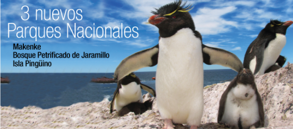
2 new marine protected areas created on Argentina's southern coasts


From WCS

The Wildlife Conservation Society applauds the Government of Argentina for creating two enormous marine protected areas in Patagonia, a region filled with majestic shorelines and abundant wildlife.

 source : Waitt foundation

The new marine parks—Isla Pingüino Coastal Marine Park and Makenke Coastal Marine Park—were recently established by the National Congress in Argentina and will safeguard sea lions, penguins, dolphins, and other marine and coastal species.

"We commend the Government of Argentina for their conservation stewardship in creating this new network of marine protected areas," said Dr. Cristián Samper, President and CEO of the Wildlife Conservation Society.
"Isla Pingüino and Makenke Coastal Marine Parks now protect vital wildlife populations for posterity and create new opportunities for Argentina's ecotourism industry."

 >>> geolocalization with the Marine GeoGarage <<<

Stretching some 80 miles south of Puerto Deseado and extending 12 miles out to sea, Isla Pingüino covers nearly 1,800 square kilometers (720 square miles) of ocean and cliff-bordered coastline.
The new protected area contains large populations of South American sea lions, red-legged cormorants, and one of the largest colonies of imperial cormorants found anywhere (with more than 8,000 breeding pairs).
Isla Pingüino also boasts one of the only colonies of rockhopper penguins on the coast of Patagonia.

 Such beauty deserves protection
Credit: G. Harris/Wildlife Conservation Society

  >>> geolocalization with the Marine GeoGarage <<<

Farther south, the Makenke Coastal Marine Park begins at the entrance of the Ría San Julián, covering almost 600 square kilometers (230 square miles) of shore and ocean.
The park contains the largest colony of rare red-legged cormorants in the country.
It also protects breeding colonies of the dolphin gull, a rare scavenger, and pods of the small but spectacular black and white Commerson's dolphin

 A distinct landscape :
the stark and scenic coastline of Makenke Coastal Marine Park
Credit: G. Harris/Wildlife Conservation Society.

Both marine protected areas are steeped in history as well as natural wonders.
Charles Darwin traveled to the region now contained in Isla Pingüino in 1833, describing the wildlife he observed there during his seminal voyage aboard the HMS Beagle.
Makenke Coastal Marine Park now borders the inlet of San Julian, where in 1520 Ferdinand Magellan executed and marooned a group of mutineers intent on aborting what would become the world's first circumnavigation of the globe.

"We commend the National Congress in Argentina for passing laws to create these new marine parks, which will protect the country's natural heritage given what will likely be an increase in development along the coast in years to come," said Dr. Julie Kunen, Director for WCS's Latin America and Caribbean Program.


Dr. Caleb McClennen, Director of WCS's Marine Program, said: "Isla Pingüino and Makenke Coastal Marine Parks continue a tradition of conservation teamwork, with organizations such as WCS providing support to the government in protecting both coastal breeding areas for mammals and birds and the marine habitats they rely upon."

Isla Pingüino and Makenke Coastal Marine Parks were made possible as a result of work conducted by Dr. Patricia Gandini, President of the National Parks Service, and Dr. Esteban Frere of the Universidad Nacional de la Patagonia Austral.
Both biologists began studying the wildlife of the coast of Santa Cruz with support of WCS in 1985.

Both areas were identified as priority conservation sites by the Patagonia Coastal Zone Management Plan project, carried out by both the Wildlife Conservation Society and the Fundación Patagonia Natural with support from the Global Environmental Facility and the UNDP (United Nations Development Program).
Support for the research was also provided by the Consejo Nacional de Investigaciones Científicas y Técnicas (Conicet).

 A place to return : Makenke contains one of the largest breeding colonies of red-legged cormorants in Argentina.
Credit: G. Harris/Wildlife Conservation Society.

WCS has been involved in the conservation of coastal Patagonia since the 1970s, beginning with Dr. Roger Payne's behavioral work on southern right whales, and continues to this day with research by WCS's Global Health Program on new threats to their survival.
WCS began a long-running study on Magellanic penguins in the 1980s.
That work led to conservation efforts that helped reduce the number of penguin deaths due to oil spills at sea from more than 40,000 a year to fewer than 1,000 annually, and helped move shipping lanes 30 miles offshore to avoid spills affecting seabird colonies.

WCS has also been conducting research on southern elephant seals, South American sea lions, rockhopper penguins, cormorants, gulls, terns, and other species that breed along the shores of Patagonia.
These studies informed the region's first atlas of breeding seabirds, a work designed to guide management decisions on fisheries and other natural resource usage.
Over the past 40 years WCS has helped Argentina transition from harvesting of coastal wildlife to a burgeoning tourism industry based on its spectacular coastal species.
These two new parks are the latest addition to the country's extraordinary marine conservation effort.

WCS's efforts to help protect wildlife on the Argentine coast and sea are generously supported by the Liz Claiborne and Art Ortenberg Foundation, the Mitsubishi Corporation Foundation for the Americas, the Waitt Foundation, and others.

Thursday, March 14, 2013

Galileo fixes Europe's position in History

 Measurements of individual Galileo horizontal position fixes performed for the first time using the four Galileo satellites in orbit plus the worldwide ground system between 1000 and 11:00 CET on Tuesday 12 March 2013, showing an overall horizontal accuracy over ESTEC in Noordwijk, the Netherlands, of 6.3 m.
The obtained accuracy in the 10 meters range fulfills expectations.

From ESA

Europe’s new age of satellite navigation has passed a historic milestone – the very first determination of a ground location using the four Galileo satellites currently in orbit together with their ground facilities.

This fundamental step confirms the Galileo system works as planned.

A minimum of four satellites is required to make a position fix in three dimensions.
The first two were launched in October 2011, with two more following a year on.

“Once testing of the latest two satellites was complete, in recent weeks our effort focused on the generation of navigation messages and their dissemination to receivers on the ground,” explained Marco Falcone, ESA’s Galileo System Manager.

This first position fix of longitude, latitude and altitude took place at the Navigation Laboratory at ESA’s technical heart ESTEC, in Noordwijk, the Netherlands on the morning of 12 March, with an accuracy between 10 and 15 metres – which is expected taking into account the limited infrastructure deployed so far.


A 3D presentation of the Galileo satellite navigation system, a joint development by the European Union and European Space Agency.
This constellation of satellites will allow users to pinpoint their location anywhere on Earth -- launched on 20 October 2011.

This fix relies on an entirely new European infrastructure, from the satellites in space to the two control centres in Italy and Germany linked to a global network of ground stations on European territory.

“The test of today has a dual significance: historical and technical,” notes Javier Benedicto, ESA’s Galileo Project Manager.
“From the historical perspective, this is the first time ever that Europe has been able to determine a position on the ground using only its own independent navigation system, Galileo.
“From the technical perspective, generation of the Galileo navigation messages is an essential step for beginning the full validation activities, before starting the full deployment of the system by the end of this year.”

With only four satellites for the time being, the present Galileo constellation is visible at the same time for a maximum two to three hours daily.
This frequency will increase as more satellites join them, along with extra ground stations coming online, for Galileo’s early services to start at the end of 2014.

With the validation testing activities under way, users might experience breaks in the content of the navigation messages being broadcast. In the coming months the messages will be further elaborated to define the ‘offset’ between Galileo System Time and Coordinated Universal Time (UTC), enabling Galileo to be relied on for precision timing applications, as well as the Galileo to GPS Time Offset, ensuring interoperability with GPS. In addition, the ionospheric parameters for single frequency users will be broadcast at a later stage.

A European partnership

The definition phase and the development and in-orbit validation phase of the Galileo programme were carried out by ESA and co-funded by ESA and the European Community.

The Full Operational Capability phase is managed and fully funded by the European Commission.
The Commission and ESA have signed a delegation agreement by which ESA acts as design and procurement agent on behalf of the Commission.