Wednesday, November 14, 2012

Gulf Stream diverted more than 100 Miles North in 2011

Observed currents in the Gulf Stream from Jan 1st to Dec 31st 2011.
This information produced by Tidetech is used by commercial shipping to save fuel and reduce emission


Last fall, fishermen in the Northeast United States noticed stronger currents and higher water temperatures than usual, so they tapped scientists from the Woods Hole Oceanographic Institution in Massachusetts to help them find out what was going on.

A study by the scientists, published recently in the journal Scientific Reports, suggests the cause was a change in the direction of the Gulf Stream, the current that ferries warm water from the Gulf of Mexico northeast into the Atlantic and along the U.S. East Coast.
The scientists found that the center, or core, of the Gulf Stream was diverted as much as 125 miles (200 kilometers) to the north of its average position, according to a WHOI statement.

The figures show the maximum sea surface temperatures for the periods (a) October 12–21, 2011, and (b) December 1–15, 2011.
The coastline and shelfbreak are indicated by the thin black contours.
The dashed black lines in (a) and (b) denote the climatological mean location of the Gulf Stream North Wall in October and December. 
In (a), the blue line denotes the path of a surface drifter released off Cape Fear, NC,  on October 12, 2011, that was entrained in the Gulf Stream and reached Georges Bank 8 days later.
The drifter's speed (blue) and course (red) are shown as functions of latitude in (c).
In (a–b), the blue star indicates the location of the OOI test mooring, and the magenta squares denote the locations of the eMOLT observations.
(Image courtesy Robert Todd, Woods Hole Oceanographic Institution)

In late October 2011, temperatures increased at two deep-water sensors attached to lobster traps off Nantucket by as much as 12 degrees Fahrenheit (6.7 degrees Celsius) over the course of several days. That pushed water temperatures above 64 F (18 C), which is very unusual in the waters off southern New England for that time of year.  It's also 4 F (2 C) higher than temperatures have been at one of these locations in the last decade, said study author and WHOI researcher Glen Gawarkiewicz.

While the diversion lasted for only a couple weeks, the warm water stuck around for months, into early 2012.
The strange conditions likely had and will have an effect on marine life near the edge of the continental shelf, the underwater extension of the North American continent that creates relatively shallow waters until it abruptly drops off.
The continental shelf off the Northeast is home to an abundance of fish. Studies in Northeast waters have shown that temperature increases of 4 F (2 C) have caused major northward shifts in populations of silver hake, a commercially important fish.
Contours of satellite-derived SSH from Aviso's near-real-time merged absolute dynamic topography. Contour interval is 10 cm with 40-cm (heavy red) and 10-cm (yellow) contours highlighted.
Black dots represent the mean Gulf Stream path determined from SSH gradients along descending altimeter tracks15.
Green dots represent the drifter positions over 7 days centered on the individual SSH snapshots.
Shading indicates bathymetry in meters, with the 200-m isobath shown by the black contour.
Blue star and magenta squares denote the moored profiler and eMOLT sites

In spring 2012, migratory bluefish and striped bass were also seen off the coast of Cape Cod much earlier than in previous years.
But more research is required to determine if the Gulf Stream diversion was the cause.

It's still unclear exactly why the Gulf Stream shifted so far to the north, Gawarkiewicz told OurAmazingPlanet.
One possible explanation is that the heavy rainfall dropped by Hurricane Irene affected its course by altering ocean salinity.
Another possibility is that it was jolted northward by an eddy of cold water off the southeastern United States that appeared in the fall of 2011, he said.

Typically, the Gulf Stream only indirectly influences ocean currents and temperatures near the continental shelf south of New England when eddies separate from the Gulf Stream and drift northward,  causing limited warming.

Tuesday, November 13, 2012

Ancient map irrefutable evidence that the Diaoyu Islands, the ancient belongs to China

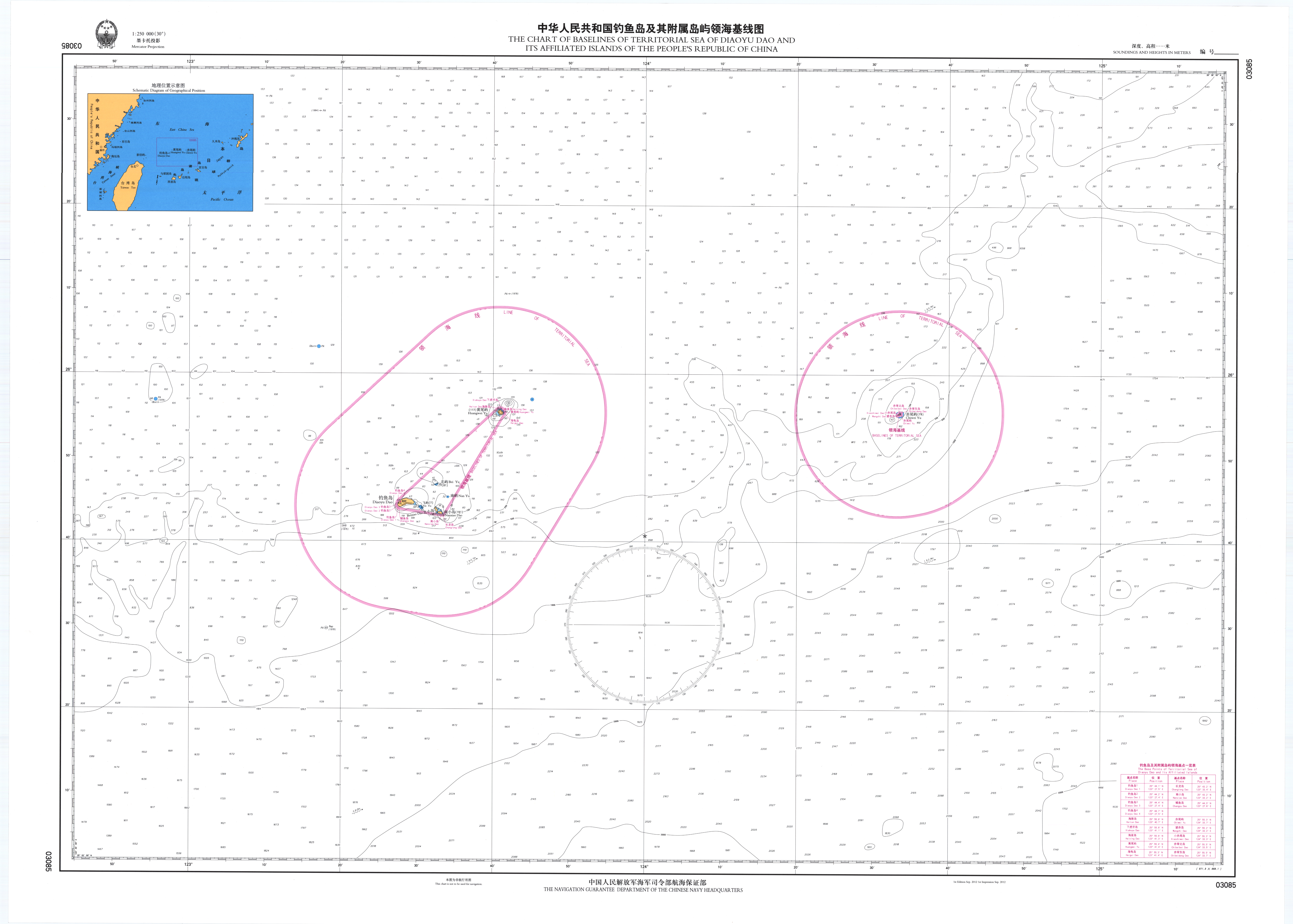
Deposit of a chart and of a list of geographical coordinates as contained in the Statement of the Government of the People’s Republic of China on the Baselines of the Territorial Sea of Diaoyu Dao and its Affiliated Islands (UNCLOS 21 september 2012)

From WindowNews

According to Hong Kong Ta Kung Pao, the Japanese government 'nationalized' Diaoyutai acts despicable global Chinese simultaneous roar, engaged in the ancient map collection and research for over 30 years Hong Kong experts SC Tam photo card, show 300 years ago, ancient maps, to prove that the Diaoyu Islands has always been China's territory.

SC Tam nautical charts show the eighteenth century, Diaoyutai is Chinese territory.
Source: Hong Kong Ta Kung Pao

SC Tam said the old maps marked names that China as early as found in Japan over the Diaoyu Islands is named as the Diaoyu Islands.
Showed him a 1787 French rendering of 'discovery chart' on 'Fishing Island', 'vase Lantau transliteration, with the Minnan Pinyin SC Tam explained sovereignty involved in the discovery, naming and use, because China had discovered the Diaoyu Islands, then draw the map of the West naturally Minnan transliteration used by the people along the coast of China to label these maps .

Uotsuri island (the largest of the island group, with an area of 4.32 km2), part of the disputed islands in the East China Sea, known as the Senkaku isles in Japan, Diaoyu islands in China

SC Tam added maps and written means, as early as in 1372, the Chinese ambassador to the Ryukyu Ambassador Yang set out in the Diaoyu Islands the erect 'Fishing Island' monument, refers to 1884 than the Japanese side, there have been recorded live in Japan over the Diaoyu Islands hundreds of years earlier.

 Blatant fabrications Diaoyu Islands history (TheChina.com)

Former Head of the Department of History of the University of Hong Kong Lvyuan Cong refers Sovereignty over Diaoyu Islands is not just a problem of the island, involving vast territorial waters, must not easily let go, while the Diaoyu Islands closest to Taiwan, from Taiwan to come forward to recover the Diaoyu Islands most suitable, but also easier to get international recognition.

Liao Liqiang, China's current Ambassador to Belgium, said he discovered a map in a bookstore in Brussels which was drawn in 1832 by a French colonel.
It referred to the Diaoyu Islands as "Tiaoyu-Su", a Chinese southern Fujian dialect pronunciation for the territory. For him, the discovery adds new proof to China's sovereignty over the Diaoyu Islands.

 China 1875, a German map showing Diaoyu Islands (Tiao Su) upon Google Maps
David Rumsey historical map collection in the GeoGarage

Diaoyu Islands in the map are only a small desert island, but decisive, strategic places 'super radar installed on the island, you can monitor the entire Pacific, even firing missiles had!'
SC Tam, Chiang Kai-shek one had been made by the Ryukyu to Taiwan between, including the Fishing Islands area, the strategic importance of China, Japan's attempt to invade Taiwan, it is intended as a transit point to the Diaoyu Islands Diaoyu Islands more natural resources reserves, into a battleground, 'very Nangao'.

A Japanese survey team has visited a group of disputed islands in the East China Sea.
The governor of Tokyo has a plan to buy some of the privately held islands and then hand them over to the Japanese government in order to strengthen that country's territorial claim.
The Chinese government, however, says the islands belongs to China.

SC Tam sigh, China has long been ignored sovereignty over the area, not only so that the Diaoyu Islands as the 'Overseas wild earners sovereignty is also controversial in recent years overseas were frequent, such as the Huangyan Island, Xisha, he believes the Japanese side proposed purchase Diaoyu Islands, because of the weakness of the Japanese government politicians fundraising purchased Island and other means to fight for public opinion. ahead, he expected the effort collection donated to the United Nations and China to provide evidence for international sovereignty disputes.

Links :

Monday, November 12, 2012

US NOAA update in the Marine GeoGarage


43 charts have been updated in the Marine GeoGarage
(NOAA update September/October 2012) 
    • 11306 Intracoastal Waterway Laguna Madre Middle Ground to Chubby Island
    • 11342 Sabine Pass and Lake
    • 11382 Pensacola Bay and approaches
    • 11384 Pensacola Bay Entrance
    • 11390 Intracoastal Waterway East Bay to West Bay
    • 11532 Winyah Bay
    • 11543 Cape Lookout to New River
    • 11550 Ocracoke lnlet and Part of Core Sound
    • 12278 Chesapeake Bay Approaches to Baltimore Harbor
    • 12316 Intracoastal Waterway Ocean City to Cape May
    • 14835 Erie Harbor
    • 16595 Kodiak and St. Paul Harbors;Kodiak Harbor
    • 16596 Womens Bay
    • 17300 Stephens Passage, Chatham Strait, Icy Strait and Lynn Canal
    • 17312 Hawk Inlet, Chatham Strait
    • 17376 Lynn Canal-Funter Bay
    • 19367 Island of Oahu Honolulu Harbor
    • 19369 Oahu South Coast Approaches to Pearl Harbor
    • 25683 Bahia de Ponce and Approaches
    • 11319 Intracoastal Waterway Cedar Lakes to Espiritu Santo Bay
    • 11372 Intracoastal Waterway Dog Keys Pass to Waveland
    • 11383 Pensacola Bay
    • 11488 Amelia Island to St. Augustine
    • 11531 Winyah Bay to Bulls Bay
    • 11548 Pamlico Sound Western Part
    • 12274 Head of Chesapeake Bay
    • 12352 Shinnecock Bay to South Oyster Bay
    • 12364 Long Island Sound-New Haven Harbor Entrance and Port Jefferson to Throgs Neck
    • 12365 South Shore of Long Island Sound Oyster and Huntington Bays
    • 12371 New Haven Harbor;New Haven Harbor (Inset)
    • 12377 Connecticut River Deep River to Bodkin Rock
    • 13003 Cape Sable to Cape Hatteras
    • 13200 Georges Bank and Nantucket Shoals
    • 14917 Menominee and Marinette Harbors
    • 16522 Beaver Inlet
    • 16528 Unalaska Bay and Akutan Pass
    • 16741 Icy Bay
    • 17386 Sumner Strait-Southern part
    • 18010 Monterey Bay to Coos Bay
    • 18447 Lake Washington Ship Canal and Lake Washington
    • 18468 Port Angeles
    • 18558 Tillamook Bay
    • 18685 Monterey Bay;Monterey Harbor;Moss Landing Harbor;Santa Cruz Small Craft Harbor
      Today 1021 NOAA raster charts (2166 including sub-charts) are included in the Marine GeoGarage viewer.

      Note : NOAA updates their nautical charts with corrections published in:
      • U.S. Coast Guard Local Notices to Mariners (LNMs),
      • National Geospatial-Intelligence Agency Notices to Mariners (NMs), and
      • Canadian Coast Guard Notices to Mariners (CNMs)
      While information provided by this Web site is intended to provide updated nautical charts, it must not be used as a substitute for the United States Coast Guard, National Geospatial-Intelligence Agency, or Canadian Coast Guard Notice to Mariner publications

      Please visit the
      NOAA's chart update service for more info.

      Marine 'treasure trove' could bring revolution in medicine and industry

      A water bear (Paramacrobiotus craterlaki).
      Scientists believe micro-organisms could be used to create everything from new medicine to industrial solvents.


      Scientists have pinpointed a new treasure trove in our oceans: micro-organisms that contain millions of previously unknown genes and thousands of new families of proteins.

      These tiny marine wonders offer a chance to exploit a vast pool of material that could be used to create innovative medicines, industrial solvents, chemical treatments and other processes, scientists say.
      Researchers have already created new enzymes for treating sewage and chemicals for making soaps from material they have found in ocean organisms.

      "The potential for marine biotechnology is almost infinite," said Curtis Suttle, professor of earth, ocean and atmospheric sciences at the University of British Columbia.
      "It has become clear that most of the biological and genetic diversity on Earth is – by far – tied up in marine ecosystems, and in particular in their microbial components. By weight, more than 95% of all living organisms found in the oceans are microbial. This is an incredible resource."

      However, the discovery of the ocean's biological riches, including hundreds of thousands of new sponges, bacteria and viruses, also raises worries about the damage that could ensue from the new science of marine biotechnology.

      In particular, scientists worry that precious sources, including hydrothermal vents where bacteria and simple plants thrive in water above boiling point, could be damaged or destroyed in a free-for-all rush to exploit these wonders.

      In addition, major worries focus on developing nations whose waters contain rich sources of marine life that could be targeted and exploited by western chemical companies.
      On land, patents can provide protection for products derived from local animals or plants.
      In the sea, where currents carry fish, sponges and microbes from place to place, such protection could be far trickier to enforce.

      The issues are set to top the agenda at a biotechnology forum, The Evolving Promise of the Life Sciences, that the Organisation for Economic Co-operation and Development (OECD) and the UK Economic and Social Research Council (ESRC) genomics forum are holding in Paris on Monday.

      "We have controls for regulating the exploitation of animals, plants and microbes on land, but regulating them at sea is going to be much more difficult," said Professor Steve Yearley, head of the ESRC genomics forum and organiser of tomorrow's meeting.
      "We cannot stop pirates off Somalia, so how is someone supposed to protect rare sponges that they find in their coastal waters?"

      Tectitethya crypta
      (Location: Sweetings Cay, Bahamas    Photographer: Sven Zea)

      Sponges turn out to be a particularly promising marine resource.
      The sponge Tethya crypta, found in Belize and other parts of the Caribbean, has been found to contain chemicals that have anti-cancer and anti-viral properties.
      Similarly, the cancer drug Halaven was derived from sponges of the Halichondria family.

      To date, only a handful of drugs derived from marine biotechnology sources have been approved by the US Food and Drug Administration.
      However, more than 1,000 new ones are undergoing pre-clinical tests.
      These include products derived from molluscs, snails, marine microbes and fish.

      The science of marine biotechnology was kickstarted five years ago by the entrepreneur Craig Venter. One of the scientists involved in the sequencing of the human genome, Venter set off in his yacht in a round-the-world cruise intent on demonstrating the potential of the biological material that is found in sea water.
      In the end, he made two journeys, one from 2006-8 and the other from 2009-11.
      On both expeditions, scientists took 200-400 litre samples of sea water every 200 miles, put these through progressively smaller filters to capture the organisms in the samples, then froze the captured micro-organisms for shipment back to his laboratory
      There scientists sequenced their DNA using techniques developed by Venter on sequencing the human genome.

      The results were staggering.
      According to Venter, his team discovered around 20m new genes and thousands of new families of proteins in the samples they scooped up on their journeys through the world's oceans.
      As yet, no one knows what these genes and proteins do, although most researchers believe many of them must have potential as sources of new drugs.

      "We are struggling to develop the right techniques to isolate and understand the marvels we are finding in the waters around the planet," said Yearley."
      "Once we have done that, then we will have a much better idea just what we are looking at and just how careful we need to be when it comes to ensuring this resource is protected for the future."