Sunday, July 31, 2011

Where on Earth...? MISR Mystery Quizzes

Parallel contest : locate in the Marine GeoGarage and win a 'Premium Chart' subscription

From NASA

Welcome back to another chance to play geographical detective!

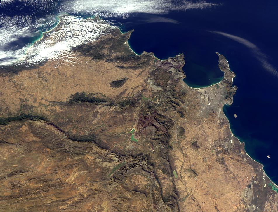
This image was taken by the Multi-angle Imaging SpectroRadiometer (MISR), and represents an area of about 262 kilometers by 200 kilometers. Please note that due North may not be at the top of the page. These questions refer to a landmark, area or province within the pictured region. Please answer the questions below and tell us where on Earth you think the location is. You may use any reference materials you like to answer the quiz.

From the statements below, please indicate which are TRUE and which are FALSE.

  1. Located within the lower third of the image is a dramatic landmark that has lain dormant for thousands of years.
  2. The southwest part of the region pictured overlooks a capital city.
  3. This area was once rich in biodiversity. However, urbanization over the past several decades has reduced the wealth of flora and fauna in the region by nearly 30 percent.
  4. One of the seven natural wonders of the world lies to the northeast of this region, less than a week away by car.
  5. The highest point in this region, located near the peninsula shown in the image, was first successfully climbed in the 16th century, according to records.
  6. The country in which this region is located is home to one of the world’s largest (by volume) rivers.
  7. On the west coast of the region pictured lies a World Heritage Site surrounded by water.

What location is shown in this image?

Quiz Rules

Send us your answers, name (initials are acceptable if you prefer), and your hometown by the quiz deadline of Wednesday, August 3, 2011, using the Quiz answer form. Answers will be published on the MISR web site. The names and home towns of respondents who answer all questions correctly by the deadline will also be published in the order responses were received. The first 3 people on this list who are not affiliated with NASA, JPL, or MISR and who have not previously won a prize will be sent a print of the image.

A new "Where on Earth...?" mystery will appear periodically. The image also appears on the Earth Observatory, http://earthobservatory.nasa.gov/, and on the Atmospheric Sciences Data Center home pages, http://eosweb.larc.nasa.gov/, though usually with a several-hour delay.

Saturday, July 30, 2011

Shuttle Discovery over the Americas

>>> geolocalization with the Marine GeoGarage <<<

“Photographs from the Space Shuttle are punctuated snapshots of distinct places on Earth,”
says Cindy Evans, an Earth scientist and long-time trainer and ground-based guide to astronauts.
“They are framed by a human eye and perspective, and they are accessible to anyone. These images speak to people. ”


From NASA

The summer of 2011 has been a time of nostalgia and blessings-counting for much of the NASA family.
The final flight of the Space Shuttle program has us remembering many triumphs, fallen heroes, and signature moments.

It also has us thinking about the next giant leaps for humanity and for Earth science.
In the meantime, there is an actual mission going on, which you can follow here.

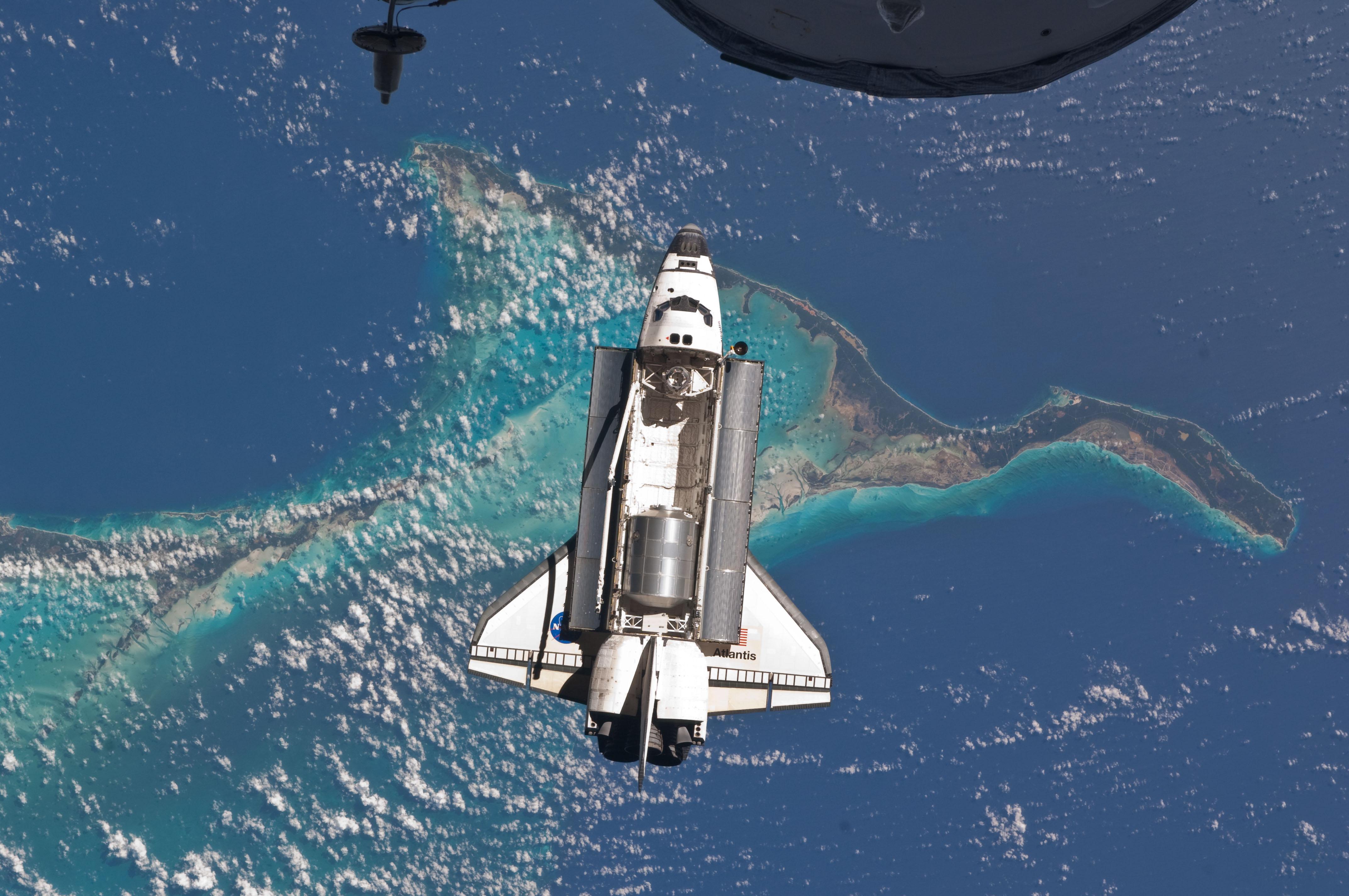
In this astronaut photograph, the Space Shuttle Atlantis approaches the International Space Station for docking for the last time on July 10, 2011.
Part of a Russian Progress spacecraft, also docked to the station, pokes into the upper foreground.
Beneath them all lie the teal-colored shallows around the Bahamas.


NASA's Shuttle Discovery (STS131), while docked to the ISS,
captured these images on April 16, 2010.
The sequence begins as the Shuttle emerges from darkness over the Canadian Rockies, traversing the United States southeast towards Florida.
The Bahamas and Hispaniola are seen as the Shuttle continues over Venezuela, Brazil and finally the southern Atlantic ocean before returning to darkness.

Friday, July 29, 2011

Celebrating Japan Marine Day by exploring the Shinkai

Learn more about life at the bottom of the sea as the Shinkai 6500 explores the Google Earth ocean.

From GoogleLatLon

The ocean covers approximately 70 percent of the Earth’s surface and yet remains one of the most mysterious places on the planet.
In Japan, bodies of water with depths over 200m (656 feet) are referred to as shinkai, or deep sea.
These dark regions of the ocean do not receive light and water pressure is up to 100x higher than at the surface, making the shinkai inaccessible to most exploration.

In honor of Marine Day in Japan, we collaborated with JAMSTEC (Japan Agency for Marine-Earth Science and Technology) and the manned Shinkai 6500 submarine to share this hidden world through Google Earth. Dive beneath the surface to explore the shinkai, as well as shipwrecks, research discoveries, surf spots and more.

The Shinkai 6500 is able to dive to depths of 6,500m (21,325 feet), a feat few other vessels can match. It is equipped with a variety of research devices such as search lights, cameras and robotic arms. A cockpit enables three pilots to withstand the extreme conditions and even includes a spyglass for visual exploration of the deepest parts of the ocean.


Shinkai 6500’s cockpit

Shinkai 6500’s mission is to bring the secrets of the deep sea to the surface for marine enthusiasts.
It studies movement of the Earth’s interior, living organisms equipped to survive the most extreme conditions and the impact of hydrothermal activity on the environment.

In order to bring this research to life, we worked with JAMSTEC to create a Google Earth tour showcasing past Shinkai 6500 endeavors to the ocean floor.
Join the crew by downloading the KML file (in English or Japanese) and opening in Google Earth.


The Shinkai 6500 tour highlights previous deep sea missions and marine life.

As the submarine descends, you will learn more about the vessel and the creatures it finds in the deepest parts of the ocean, including historical imagery from past ventures.
Discover unique deep sea features and lifeforms - from rare translucent fish such as the Liparis to hydrothermal vents known as white smokers.

We hope the Shinkai 6500 inspires you to continue to explore the deep sea and its hidden treasures.
We recommend starting with the ocean seafloor tour or deep sea vents ridge 2000.
You can find even more ocean tours in the Ocean Showcase on the Google Earth website.

Links :

Thursday, July 28, 2011

The world's largest ocean canyon


The largest canyon in the ocean is Zhemchug Canyon, a giant underwater canyon located in the middle of the Bering Sea.
The canyon has a vertical relief of 2600 meters dropping from the shallow shelf the Bering Sea to the depths of the Aleutian Basin.
Zhemchug Canyon is deeper than the Grand Canyon in the United States.


>>> geolocalization with the Marine GeoGarage <<<

From TheTelegraph

Seven hundred feet below the water, deep in the submarine canyon off Monterey Bay, there is complete darkness.

Creatures almost entirely beyond our comprehension have evolved here, and this week they were joined by Richard Hammond.
Hammond was presenting his Journey to the Bottom of the Ocean (BBC Two), but even set against some jaw-dropping imagery of underwater volcanoes and a giant virtual Earth, to these eyes he is a distraction.

His route from Top Gear’s Norman Wisdom to the godhead of prime-time science is as mystifying as the provenance of neon squids deep in the abyss.
The fact that the full title of this programme was Richard Hammond’s Journey to the Bottom of the Ocean tells you that BBC executives believe that he has reached a level where it’s “The Hamster”, as much as the wonders of our planet, that gets the bums on seats.

Which means that what was otherwise an impressive science documentary was continually forced to accommodate its star man.
Nods to his Top Gear persona meant he had to keep doing things such as going for dives, or descending in submersibles, to no discernible end.
Every machine was a “serious bit of kit” to get boyishly overexcited about.
And every excursion was served up with just a splash of potential peril, because Hammond is the TV guy who does daring things in serious bits of kit.

Perhaps if he came with a dab more authority – he is not, and has never claimed to be, any kind of scientist – his presence would feel less intrusive.
But when one of the most astonishing natural marvels on display is a small man’s haircut, then you know that the presenter needs to step out of the picture.

Links :

Wednesday, July 27, 2011

Brazil DHN update in the Marine GeoGarage

1512 Porto do Rio de Janeiro

14
charts have been updated (DHN update June 30)

  • 60 DO RECIFE A BELMONTE
  • 90 DA ILHA DE SANTA CATARINA A MALDONADO
  • 1501 BAÍA DE GUANABARA
  • 1503 ENSEADA DO CABO FRIO
  • 1512 PORTO DO RIO DE JANEIRO
  • 1517 PROXIMIDADES DA PONTA DO MATOSO
  • 1632 BAÍA DA ILHA GRANDE PARTE CENTRO NORTE
  • 1636 PORTO DE ANGRA DOS REIS E PROXIMIDADES
  • 1820 PROXIMIDADES DA BARRA DE PARANAGUÁ
  • 1821 BARRA DE PARANAGUÁ
  • 2101 PORTO DO RIO GRANDE
  • 2110 PROXIMIDADES DO PORTO DE RIO GRANDE
  • 21080 DO CABO DE SANTA MARTA GRANDE AO ARROIO CHUÍ
  • 21200 DA PONTA TUCUMÃ À PONTA DO GUARÀ
Today 238 charts (283 including sub-charts) from DHN are displayed in the Marine GeoGarage