Wednesday, July 27, 2011

Fickle Aral Sea sees some recovery


From OurAmazingPlanet

The size of the Aral Sea has long hinged on the Amu Darya, which flows from the high Pamir Mountains in central Asia, across the desert, and into the southern sea.
While two rivers empty into the lake—the Amu Darya and the Syr Darya—the Amu Darya is the largest and most fickle source of water.
At times in ancient history, the river has bent its course to empty into the Caspian Sea, and the abandoned Aral Sea shrank.
The Aral Sea has been at its largest when the Amu Darya feeds it.

Modern trends are no exception: when water began to be diverted from the Amu Darya for vast agricultural projects starting in 1960, the Aral Sea began to shrink.
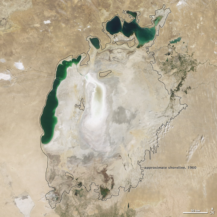
This image, taken on August 26, 2010, by the Moderate Resolution Imaging Spectroradiometer (MODIS) on NASA’s Terra satellite, demonstrates the close connection between the Aral Sea and the Amu Darya River.
It is the most recent image in a ten-year sequence published on the Earth Observatory’s World of Change: Shrinking Aral Sea.

Between 2000 and 2009, the Aral Sea steadily shrank.
In 2006, severe drought settled in over Amu Darya Basin.
Very little water reached the Aral Sea in 2007, and nothing flowed from the Amu Darya to the Aral Sea in 2008 and 2009, says Philip Micklin, a geographer from Western Michigan University who has been monitoring the Aral Sea for many years.
Without water from the Amu Darya, the southern Aral Sea rapidly dwindled, the eastern lobe all but disappearing in 2009.

In 2010, however, the drought broke.
Snow in the Pamir Mountains was normal, and enough water flowed into the Amu Darya that the river reached the Aral Sea.
The muddy pulse of water settled in a shallow layer over the bed of the eastern lobe of the South Aral Sea, making it look much larger than it had in 2009.

Before 1960, the Aral Sea was the fourth largest lake in the world.
However, much of the Amu Darya and Syr Darya have been diverted for agriculture, limiting the flow of water into the sea.
Since 1960, the Aral Sea has lost 88 percent of its surface area and 92 percent of its water volume, says Micklin.

Links :

Canada CHS update in the Marine GeoGarage

4307 Canso Harbour

39 charts have been updated (July 11) :

  • 1429 CANAL DE LA RIVE SUD
  • 1430 LAC SAINT-LOUIS
  • 1431 CANAL DE BEAUHARNOIS - LAC SAINT-LOUIS TO SAINT FRANCOIS
  • 3002 QUEEN CHARLOTTE SOUND TO / DIXON ENTRANCE
  • 3410 SOOKE INLET TO PARRY BAY
  • 3440 RACE ROCKS TO D'ARCY ISLAND
  • 3447 NANAIMO HARBOUR AND DEPARTURE BAY
  • 3538 DESOLATION SOUND AND SUTIL CHANNEL
  • 3726 LAREDO SOUND AND APPROACHES
  • 3737 LAREDO CHANNEL - INCLUDING LAREDO INLET AND SURF INLET
  • 3910 PLANS - MILBANKE SOUND AND BEAUCHEMIN CHANNEL
  • 3911 PLANS - VICINITY OF PROXIMITE DE PRINCESS ROYAL ISLAND
  • 4001 GULF OF MAINE TO STRAIT OF BELLE ISLE
  • 4003 CAPE BRETON TO CAPE COD
  • 4010 BAY OF FUNDY INNER PORTION
  • 4011 APPROACHES TO BAY OF FUNDY
  • 4020 STRAIT OF BELLE ISLE
  • 4277 GREAT BRAS D'OR / ST. ANDREWS AND ST. ANNS BAY
  • 4278 GREAT BRAS D'OR AND ST PATRICKS CHANNEL
  • 4307 CANSO HARBOUR TO STRAIT OF CANSO
  • 4308 ST. PETERS BAY TO STRAIT OF CANSO
  • 4320 EGG ISLAND TO WEST IRONBOUND ISLAND
  • 4381 MAHONE BAY
  • 4386 ST MARGARET'S BAY
  • 4422 CARDIGAN BAY
  • 4485 CAP DES ROSIERS TO CHANDLER
  • 4486 CHALEUR BAY
  • 4652 HUMBER ARM - MEADOWS POINT TO HUMBER RIVER
  • 4852 SMITH SOUND AND RANDOM SOUND
  • 4853 TRINITY BAY - NORTHERN PORTION
  • 4857 INDIAN BAY TO WADHAM ISLANDS
  • 4905 CAPE TORMENTINE TO WEST POINT
  • 4906 WEST POINT TO BAIE DE TRACADIE
  • 4909 BUCTOUCHE HARBOUR
  • 4913 CARAQUET HARBOUR BAIE DE SHIPPEGAN AND MISCOU HARBOUR
  • 4921 HAVRE DE BEAUBASSIN
  • 4956 CAP-AUX-MEULES
  • 6287A MINAKI TO KENORA - 1
  • 6287B MINAKI TO KENORA - 2

14 charts have been withdrawn or replaced :

  • 1409 replaced by 1429
  • 1410 replaced by 1430
  • 3710 replaced by 3910,3911 (new)
  • 3711 replaced by 3910,3911 (new)
  • 3717 withdrawn
  • 3719 replaced by 3910,3911 (new)
  • 3722 replaced by 3945,3946
  • 3723 replaced by 3910,3911 (new)
  • 3740 withdrawn
  • 3746 replaced by 3984
  • 3747 replaced by 3985,3986
  • 3753 withdrawn
  • 3761 replaced by 3987
  • 3773 withdrawn

So 774 charts (1643 including sub-charts) are available in the Canada CHS layer. (see coverage)

Note : don't forget to visit 'Notices to Mariners' published monthly and available from the Canadian Coast Guard both online or through a free hardcopy subscription service.
This essential publication provides the latest information on changes to the aids to navigation system, as well as updates from CHS regarding CHS charts and publications.
See also written Notices to Shipping and Navarea warnings : NOTSHIP

Tuesday, July 26, 2011

Cross-species gadget tests reveal reason for dolphin tools


Shark Bay : >>> geolocalization with the Marine GeoGarage <<<

From Wired

The dolphins of Australia’s Shark Bay, famed as Earth’s first marine tool users, likely turned to gadgetry because echolocation couldn’t find the best fish, especially for hurried moms without time to hunt.

It was in 1984 that researchers first observed the dolphins fitting basket sponges over their beaks, then scraping through seafloor mud to disturb hidden fish.
Research subsequently showed this behavior to be full-blown tool use, taught by mothers to their daughters and representing a profound difference in lifestyle between them and Shark Bay’s other bottlenoses.

A basic question remained unanswered, however: Though sponges clearly protected sensitive dolphin snouts from jagged pieces of rock and coral, why scrape seafloor at all?
Why not rely on echolocation to pinpoint target prey?


Sponging in Shark Bay.
(A) marine basket sponge (Echinodyctium mesenterinum),
(B) dolphin wearing a sponge on its rostrum,
(C) substrate littered with rock, shell, and debris,
(D) hiding prey, barred sandperch (Parapercis nebulosa).
All photographs taken by Eric M. Patterson.

In a study published July 20 in Public Library of Science ONE, biologists Eric Patterson and Janet Mann of Georgetown University set out to answer this question by mounting basket sponges on sticks and pushing them through Shark Bay seafloors, just as dolphins do.

Most fish scared from the muck were bottom-dwellers lacking swim bladders, the air-filled organs that help fish control their buoyancy.
Compared to fish flesh, which interferes with acoustic signals just slightly more than water, air bladders stand out on sonar.
Without them, bottom-dwelling fish are nearly invisible to echolocation.
Hence the value of scraping through seafloors manually, and thus the need for a device that protects dolphin noses from scraping.

Hunting with sponges has allowed Shark Bay’s bottlenoses to fill an empty ecological niche, eating fish that other dolphins ignore, wrote Patterson and Mann.
The findings also suggest why sponge foraging likely arose among Shark Bay’s females and has remained their province, taught by dolphin mothers to daughters rather than sons.

Whereas dolphin fathers are mostly absent, free to roam and chase prey in the open ocean, dolphin moms spend years with their calves.
They need to put food on the figurative table but have little time to do it.
Sponge-fishing is convenient and nutritious, a family recipe for quick-but-delicious dinners passed on to daughters who will someday need it.

Links :

Monday, July 25, 2011

BP spill stopped one year ago : 5,000 spills since then

NRC oil and hazardous materials spill reports, July 15, 2010 - July 15, 2011 :
about 3,000 reports that have enough usable location informationo pinpoint them on a map

From SkyTruth

July 15, 2010 was a day of relief for many - even for folks up here in West Virginia - after 2-1/2 months watching helplessly as oil and gas billowed relentlessly into the Gulf of Mexico from BP's runaway Macondo well.
On that day one year ago, the final valve was carefully closed on an improvised "capping stack" that did the job after a string of heartbreaking failures.
By that time an estimated 172 million gallons of oil had spewed directly into the Gulf, vastly exceeding the Exxon Valdez tanker spill of 1989 -- making it the nation's worst oil spill, and the world's worst accidental spill.

After cumulatively covering an area the size of Oklahoma, the massive oil slicks on the Gulf's surface began to dissipate almost immediately under the steady assault of evaporation, wind and wave action, biodegradation, photolysis, and cleanup efforts.
We last observed significant oil slicks on satellite images taken July 28.


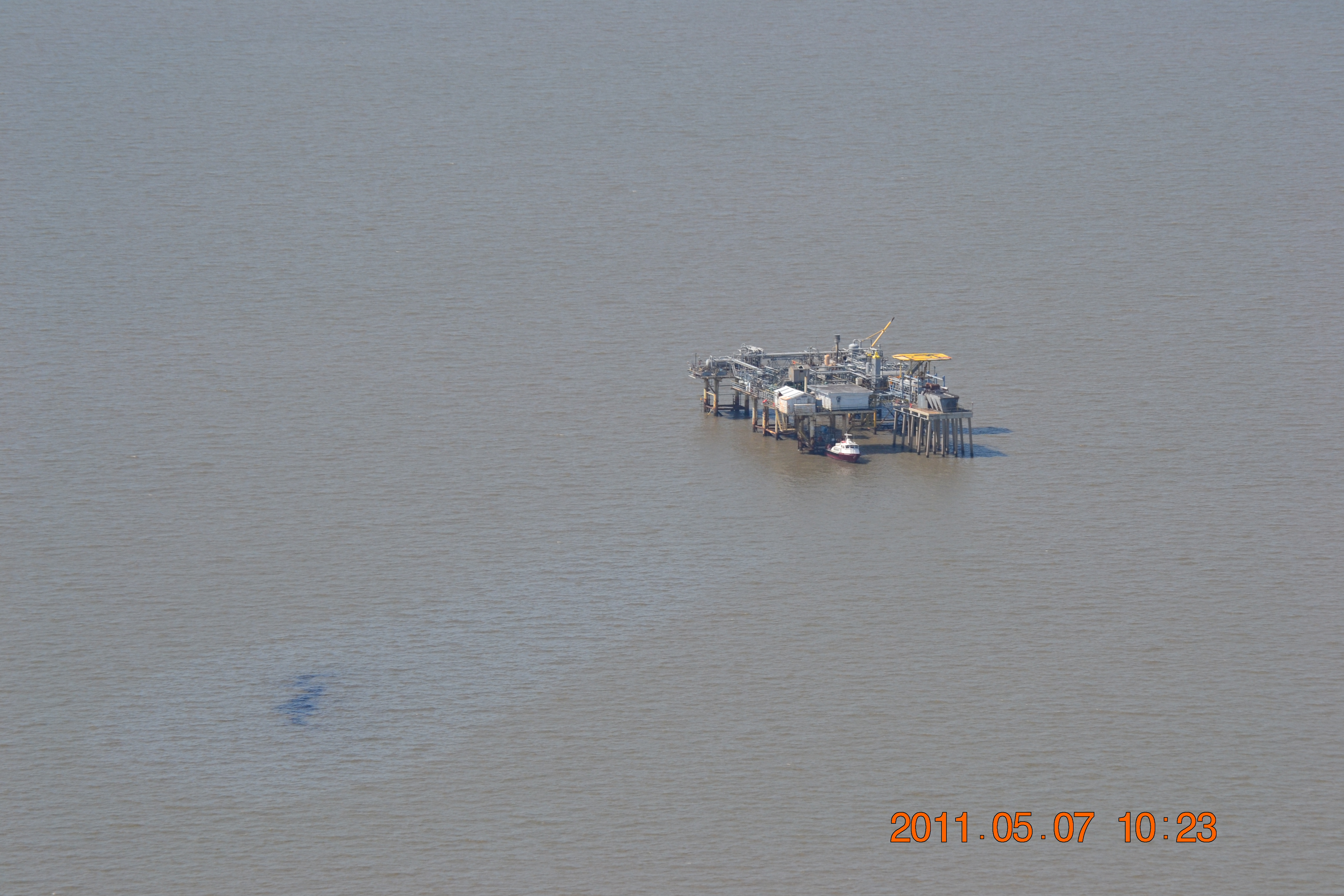
Aerial photograph taken May 7, 2011 showing apparent oil leak originating from an oil and gas production platform in state waters 1.1 miles off the Louisiana coast, 37 miles east of Grand Chenier.
Unknown if this was a one-time release or a chronic leak.
Photograph by Jamie Ward, courtesy of SouthWings and pilot Dan Luke.

But unknown amounts of oil and chemical dispersant lingered beneath the ocean's surface, out of sight, with an uncertain fate and as-yet untallied environmental consequences.
What is clear is that this spill caused significant economic damage to the Gulf seafood and tourism industries, upsetting the lives and livelihoods of people as far away as Virginia.
And oil from the spill continues to wash ashore along the Gulf coast.

Meanwhile, Congress has yet to pass any new laws governing offshore drilling safety.
In fact, they are going backwards by reducing funding for government inspections and oversight -- despite the fact that the oil industry itself requested more funding for BOEMRE, the agency that manages offshore drilling.

Other frustrations?
Oh yeah, and the 5,100 new oil and other hazardous materials spills in the Gulf region reported to the National Response Center since July 15, 2010.

Links :
  • SkyTruth : real-time updates about environmental incidents in your back yard (or whatever part of the world you know and love)
  • TheGuardian : Oil and gas spills in North Sea every week, papers reveal

Sunday, July 24, 2011

The underwater project : documenting life below surface

The Underwater Project from Mark Tipple

"I've always been intrigued by what happens below the surface, like what's happening where we can't see."
While watching the slide-show on Mark's laptop I'm amazed at the detail of this 'other world' that's portrayed with his
selection.

As an accomplished documentary photographer, in the past Mark has used the ocean as an escape for some solace away from his projects.
Lately, while between projects he's been "hanging out" below the surface trying to capture what happens while swimming on a slow summer's day.

"Coming from a surfing background I used to wonder what happens when we're duck-diving, like, what it looks like from a different angle than what we can see. Kinda hard to explain but it has always been on my mind. I used to surf with a small video camera and housing attached to my helmet, (pauses) it worked surprisingly well but my neck couldn't take the impact and stress while trying to duck-dive and capture the right angle. Even tried to turn it back on myself to see what happens clearer but that, uh, sucked (laughs). I looked for a new approach to capture what I was seeking, which basically meant getting off the surfboard."

Links :