Wednesday, February 23, 2011

Google error puts German harbor in Dutch waters

Emden on the Marine GeoGarage with NLHO 18128 map


Google Maps puts the harbor of the northern German city of Emden inside the Netherlands. After complaints, the company is working to fix it.
But where the correct border lies is actually still a matter of dispute.

The city of
Emden in northern Germany has lost its harbor - at least according to the Internet service Google Maps.
According to maps of the area provided by the European Union, the border between the Netherlands and Germany runs neatly through the middle of the
Ems estuary, leaving Emden and its port entirely in Germany.

But Google has the gray line demarcating the border wind deep into the inner harbor so that all an Emden resident has to do to visit the Netherlands is dip a toe in the waters off the city's piers.

A couple of years ago, the city of Emden began receiving e-mails from residents upset about Google's encroaching gray line.
According to city spokesman Eduard Dinkela, Emden officials then contacted Google, alerting them to the error.
Despite repeated e-mails, he said, no one at Google had responded and Google Maps continues to make the harbor part of the Netherlands.

"It just can't be that way," Dinkela said.
"If they had used a little logic or looked at the history at all, then they would have noticed [the mistake]. But apparently no one at Google got that far or they don't do that there. In any case, they've marked it incorrectly."

An ongoing debate

But it's the history that in fact makes Google's job complicated.
Emden and its harbor sit on
Dollart Bay, part of the Ems estuary where the Ems river meets the North Sea.
On one side of the estuary is Germany and on the other side is the Netherlands.
Where the border between the two countries falls is less clear.
(see Wikipedia)

It's been an ongoing debate over the centuries and after World War II the two countries tried to come up with a formal agreement.
But they couldn't, according to Dinkela. Instead, he said, "they agreed to disagree."

Germany sees the border running along the Netherlands' dikes on the Dutch side of the estuary; the Netherlands puts it further out into the water.
But no one puts the Dutch border as far east as Google Maps. (see other viewers)

A mistake made

Google has admitted that there appears to be a mistake in the map of the German-Dutch border.
Company spokesman
Stefan Keuchel said the error may be related to the ongoing dispute.

Google gets the data for its maps from a variety of sources, he said, including local providers.
The goal is to have the most accurate and up-to-date information possible, and a "neutral or internationally recognized depiction of disputed areas."

"It's a challenge. We really work hard and are careful to interpret the data that we receive from our providers and correct any potential bias," he said.
"There seems to be a mistake and we'll work hard to correct it."

Asked why Emden hasn't heard from the Internet giant, Keuchel said the appropriate department never received the e-mail.

Links :

Global warming to have human impact within 30 years


Predicting harmful algal blooms

From RedOrbit

US scientists, speaking at the
annual meeting of the American Association for the Advancement of Science (AAAS) in Washington Saturday, said climate change could increase exposure to water-borne diseases originating in the world’s oceans, lakes and coastal ecosystems, adding that the impact will most likely be felt within the next 30 years, and as early as the next 10 years.

Numerous studies have shown that shifts from climate change make ocean and freshwater ecosystems more susceptible to toxic algae blooms and allow harmful microbes and bacteria to rapidly grow and multiply, said researchers from the National Oceanic and Atmospheric Administration (NOAA).

“These studies and others like it will better equip officials with the necessary information and tools they need to prepare for and prevent risks associated with changing oceans and coasts,” said Jane Lubchenco, Ph.D., undersecretary of commerce for oceans and atmosphere and NOAA administrator.

In one study,
NOAA researchers modeled future ocean and weather patterns to predict the effect on blooms of Alexandrium catenella, most commonly known as toxic “red tide,” which builds up in shellfish and can be fatal to humans who eat the contaminated seafood.

“Our projections indicate that by the end of the 21st century, blooms may begin up to two months earlier in the year and persist for one month later compared to the present-day time period of July to October,” Stephanie Moore, one of the scientists who worked on the study, told AFP.

Prolonged harmful algal bloom seasons could mean more days the shellfish fishery is closed, threatening the vitality of the shellfish industry.

“Changes in the harmful algal bloom season appear to be imminent and we expect a significant increase in Puget Sound and similar at-risk environments within 30 years, possibly by the next decade,” said Moore.

Natural climate variability also plays a role in the length of the bloom season from one year to the next.
Therefore, in any given year, the change in the bloom season could be more or less severe than implied by the long-term warming trend due to climate change.

In another study, NOAA scientists found that desert dust that gets deposited into oceans from the atmosphere could also lead to increases of harmful bacteria in seawater and seafood.

Researchers from the
University of Georgia found that adding desert dust to seawater significantly stimulated the growth of Vibrios -- a group of ocean bacteria that can cause gastroenteritis and infectious diseases in humans.

“It is possible this additional input of iron, along with rising sea surface temperatures, will affect these bacterial populations and may help to explain both current and future increases in human illnesses from exposure to contaminated seafood and seawater,” said the researchers.

“Within 24 hours of mixing weathered desert dust from Morocco with seawater samples, we saw a huge growth in Vibrios, including one strain that could cause eye, ear and open wound infections, and another strain that could cause cholera,”
Erin Lipp, who worked on the study, told the French news agency.

The amount of iron-rich dust that has fallen into the sea has increased over the past 30 years and is expected to continue to rise, based on precipitation trends in western Africa which are causing desertification.

Since 1996, Vibrios cases have increased 85 percent in the United States based on reports that primarily track seafood-illnesses.
It is possible this additional input of iron, along with rising sea surface temperatures, will affect these bacterial populations and may help to explain both current and future increases in human illnesses from exposure to contaminated seafood and seawater.

And researchers at the
University of Wisconsin-Milwaukee warned that an increase in rainfall could also cause more sewage overflows, which would release disease-causing bacteria, viruses and protozoa into drinking water and onto beaches.

Spring rains are expected to increase over the next 50 years, and with that increase, aging sewer systems are more likely to overflow because the ground is frozen and rainwater cannot be absorbed, said
Sandra McLellan, Ph.D., at the University of Wisconsin-Milwaukee School of Freshwater Sciences.

As little as 1.7 inches of rain in a 24-hour period can cause an overflow in spring, and the combination of increased temperatures with increased rainfall can magnify the impact.

McLellan and colleagues showed that under worst case scenarios there could be an average 20 percent increase in volume of overflows, and the overflows could last longer.

In Milwaukee, infrastructure investments have reduced sewage overflows to an average of three times per year, but other cities around the Great Lakes still experience overflows up to 40 times per year.

“Hundreds of millions of dollars are spent on urban infrastructure, and these investments need to be directed to problems that have the largest impact on our water quality,” said McLellan.
“Our research can shed light on this dilemma for cities with aging sewer systems throughout the Great Lakes and even around the world.”

In the past 10 years there have been more severe storms that trigger sewage overflows.
While there is some question whether this is due to natural variability or to climate change, these events provide another example as to how vulnerable urban areas are to climate.

“Understanding climate change on a local level and what it means to county beach managers or water quality safety officers has been a struggle,” said Juli Trtanj, director of
NOAA's Oceans and Human Health Initiative and co-author of the interagency report A Human Health Perspective on Climate Change.

“These new studies and models enable managers to better cope and prepare for real and anticipated changes in their cities, and keep their citizens, seafood and economy safe.

Links :
  • NOAA : Climate projections depict alarming human health impacts on the horizon

Tuesday, February 22, 2011

Compact semi submarine


From Mashable

Hop into this Ego Compact Semi Submarine, and without any extensive training you can be on your way to exploring the deep blue sea in no time.

Why is this called a semi-submarine?
The entire boat is not submerged, but it’s more like a pontoon boat with a transparent waterproof compartment hanging from its middle.

That means James Cameron is not going to be using one of these subs for that deep-water shoot for his Avatar sequel, but it’s still suitable for giving you an eye-popping view of the undersea world.
Think of it as more akin to snorkeling than scuba diving.

The little boat cruises along at a leisurely sightseeing pace that’s unspecified by its maker, which will only say that its batteries will last eight hours at cruising speed or four hours at top speed.

It’s built by South Korean company
Raonhaje, which plans to sell fleets of these Ego Semi-Submarines to resorts, and single units to individuals and yacht owners.
The company offers to build custom moorings for the craft, as well as hoists for yachts.

We’re thinking super-safe leisure subs like these would be a huge hit at a resort, especially seaside marinas near coral reefs, with their colorful and bustling underwater wildlife.
Just think, even people who can’t swim can enjoy the spectacular view.

Monday, February 21, 2011

Pollution Triggers genetic resistance mechanism in a coastal fish

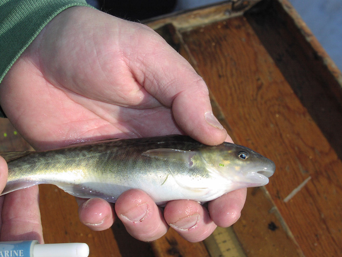
Mature tagged Atlantic tomcod collected from the Hudson River
(Mark Mattson, Normandeau Associates, Inc.)


From WHOI

For 30 years, two General Electric facilities released about 1.3 million pounds of polychlorinated biphenyls (
PCBs) into New York’s Hudson River, devastating and contaminating fish populations (see EPA).
Some 50 years later, one type of fish—the
Atlantic tomcod—has not only survived but appears to be thriving in the hostile Hudson environment.
Researchers from Woods Hole Oceanographic Institution (WHOI) have joined colleagues from New York University (NYU) and NOAA to investigate this phenomenon and report that the tomcod living in the
Hudson River have undergone a rapid evolutionary change in developing a genetic resistance to PCBs.

Although this kind of reaction has been seen when insects develop resistance to certain insecticides, and bacteria to antibiotics, “This is really the first demonstration of a mechanism of resistance in any vertebrate population,” said
Isaac Wirgin of NYU’s Department of Environmental Medicine and leader of the study. Moreover, he said, the team has found that “a single genetic receptor has made this quick evolutionary change possible.”

The findings, reported online in the
Feb. 17 issue of Science, provide a first look at “natural selection going on over a relatively short time, changing the characteristics of a population,” said WHOI Senior Scientist Mark E. Hahn, who, together with WHOI biologist Diana Franks, collaborated with Wirgin on the study.
“It’s an example of how human activities can drive evolution by introducing stress factors into the environment.”

Looking at the ability of the fish to respond to the contaminants, the researchers found the primary changes occurred in a receptor gene called AHR2, which is important in mediating toxicity in early life stages and can control sensitivity to PCBs.
In his work over the last 16 years in the Acushnet River Estuary near New Bedford, Mass., biologist Hahn has found the same gene involved in controlling other fishes’ responses to PCBs.

The AHR2 proteins in the Hudson Rover tomcod, he said, appear to be missing two of the 1,104 amino acids normally found in this protein.
This causes the receptor to bind more weakly with PCBs than normal, suggesting a reason why the contaminant does not affect the tomcod in this location as much as it does tomcod in other locations
The Hudson River tomcod “are not as sensitive to PCBs,” Hahn said. “The mechanism by which PCBs cause toxicity is dampened in this population.”

While this may be good news for the tomcod, it may bode not so well for their predators, and even humans.
“The tomcod survive but they still accumulate PCBs in their bodies and pass it on to whatever eats them,” Hahn said.

Wirgin noted that tomcod spawn in the winter, and in the summer become “a major component of the diets of striped bass and other fish.”
This can lead to “an abnormal transfer of contaminants up the food chain,” perhaps all the way to humans who may consume them.

In addition, the tomcod’s genetic changes “could make them more sensitive to other things,” and affect their ability to break down certain other harmful chemicals, such as
PAHs (polycyclic aromatic hydrocarbons), Hahn said.
“So it’s conceivable that the Hudson River tomcod could be more susceptible to PAHs because it cannot degrade them properly,” he said.

Also, he added, these receptors are involved in normal development, and a genetic change could lead to a change in a fish’s health.
“There could be evolutionary costs,” Hahn said.
“We don’t know yet what they are but it’s something that needs to be considered.”

“Hudson River tomcod have experienced rapid evolutionary change in the 50 to 100 years since release of these contaminants,” the researchers say in their paper.
Added Wirgin: “Any evolutionary change at this pace is not a good thing.”

Ironically the recently begun EPA-mandated cleanup of Hudson River PCBs could be trouble for the tomcod.
If there are evolutionary costs to having the variant AHR2 gene, the absence of the toxic substance that triggered its adaptation might leave it at a disadvantage.

“If they clean up the river,” Wirgin said, “these fish may need to adapt again to the cleaner environment.”

The WHOI portion of the study was funded by an NIH Superfund Research Program Center grant through the Superfund Research Center at Boston University.
The NYU work was funded by an NIH Superfund Research Program individual grant and an NIH Environmental Health Sciences Center grant.
"This research could not have been attempted without the unique multidisciplinary focus of our funding vehicle, Superfund Basic Research," Wirgin said.

Links :
  • Wired : Mutant fish safely store toxins in fat
  • Livescience : Fish evolved to survive GE toxins in Hudson River
  • NYTimesBlog : Speedy evolution, indeed

Sunday, February 20, 2011

Mud volcano emerges from the Arabian Sea

download large image (1 MB, JPEG) acquired January 11, 2011

download large image (962 KB, JPEG) acquired February 11, 2010


From NASA

On November 26, 2010, Pakistani fishermen returned from a day at sea to
report that a new island had emerged.
The tiny dot of land was a mud volcano, and it was still visible on January 11, 2011, when the Advanced Land Imager (ALI) on NASA’s Earth Observing-1 (EO-1) satellite acquired the top image.
The mud volcano was absent in a previous overpass on February 11, 2010, shown in the lower image.

There’s no need to change any maps, however; mud volcanoes have risen off the coast of Pakistan in the past and disappeared again within a few months, washed away by the waves and currents in the Arabian Sea.
It is quite likely that this new volcano will meet the same fate. Indeed, a stream of pale brown sediment was snaking away from the volcano to the west on January 11, suggesting that erosion was already underway.

Pakistan’s mud volcanoes form as a result of plate tectonic activity.
The Arabian plate—the section of Earth’s crust that carries the Arabian Sea—is sinking beneath the Eurasian land mass at about four centimeters per year.
Some of the thick sediment and rock on top of the Arabian plate has sloughed onto the edge of the Eurasian plate, forming Pakistan’s coastal plain, the Makran Desert, and the underwater slope leading away from the shore.
It is from this sloughed-off land that the mud volcanoes form.

Beneath the sediment, along the accretionary front, the sinking Arabian plate heats up under extreme pressure and rock melts into magma.
Volcanic gases and magma heat the groundwater, turning it in a hot acid that dissolves rock into a slurry of mud and clay.
The mud and gas seep through faults, eventually erupting at the surface as a mud volcano.

Pakistan has a number of mud volcanoes in the Makran Desert and offshore.
According to the U.S. Geological Survey, mud volcanoes are usually less than 1-2 meters (3-7 feet) tall.
But Pakistan’s
Chandragup Complex includes a mud volcano that is 100 meters (330 feet) high.

The same tectonic activity and fault systems that produce these volcanoes occasionally produce large earthquakes, such as the magnitude 7.2 quake that shook southwest Pakistan on
January 18, 2011.

Links :