Tuesday, February 1, 2011

Seahorse shape explained as stealth-attack adaptation


From Wired

According to a new explanation of seahorse shape, those distinctive S-curve bodies let them reach further than straight-bodied ancestors.

Compared to tube-shaped pipefish, their closest relatives, seahorses extend their snouts an extra 30 percent. The difference is only a few millimeters, but for animals with a strike range of a centimeter or two, it’s a big advantage.

“This makes them stealthier and sneakier hunters,” said
Lara Ferry, an Arizona State University ecomorphologist who co-authored the study, published Jan. 25 in Nature Communications. “Their prey is less likely to spot them coming, and they are less likely to miss a meal.”

To test the link between shape and hunting ability, Ferry’s team created a computer model predicting the movements of seahorses and pipefish.
By tweaking the features of the model fish, they could estimate how body curvature affected range.
They verified their results with high-speed video of seahorses and pipefish feeding.

The videos were needed, Ferry said, because the naked eye can’t see seahorses feed.
They’re among the fastest eaters known.

“From the time they spot prey and open their mouth, to the time the shrimp is completely devoured, is only four milliseconds,” said Ferry.

Seahorses rely on stealth attack because they’re poor swimmers.
While most fish, pipefish included, swim towards their prey, seahorses hide in sea grasses or corals, hang on with a prehensile tail, and wait for tiny shrimp to float by.
To prepare for a strike, they tense their muscles and — like a stretched sling-shot — snap forward.

Seahorses are also unusual for being monogamous, and are among the only species in which males bear young.

Links :
  • BBCNews : Seahorses' body shape explained

Monday, January 31, 2011

USA NOAA update in the Marine GeoGarage


13
charts have been updated in the Marine GeoGarage (NOAA update december 2010)

  • 11342 : SABINE PASS AND LAKE
  • 11384 : PENSACOLA BAY ENTRANCE
  • 11507 : BEAUFORT RIVER TO ST SIMONS SOUND
  • 11513 : ST HELENA SOUND TO SAVANNAH RIVER
  • 11521 : CHARLESTON HARBOR AND APPROACHES
  • 12345 : HUDSON RIVER GEO WASHINGTON BRIDGE TO YONKERS NY-NJ
  • 13205 : BLOCK ISLAND SOUND AND APPROACHES
  • 13214 : FISHERS ISLAND SOUND
  • 13250 : WELLFLEET HARBOR MA
  • 14929 : CALUMET AND INDIANA HARBORS
  • 17402 : SOUTHERN ENTRANCES TO SUMNER STRAIT
  • 18605 : TRINIDAD HARBOR
  • 19482 : MIDWAY ISLANDS HAWAIIAN ISLANDS
Today 1019 NOAA raster charts (2166 including sub-charts) are included in the Marine GeoGarage viewer.

Note : correction of some problem of re-projection in Mercator (introduced for the first time in the previous update last December) for the general chart 14500 for the Great Lakes (originally in Polyconic projection)

Note : NOAA updates their nautical charts with corrections published in:
  • U.S. Coast Guard Local Notices to Mariners (LNMs),
  • National Geospatial-Intelligence Agency Notices to Mariners (NMs), and
  • Canadian Coast Guard Notices to Mariners (CNMs)
While information provided by this Web site is intended to provide updated nautical charts, it must not be used as a substitute for the United States Coast Guard, National Geospatial-Intelligence Agency, or Canadian Coast Guard Notice to Mariner publications

Please visit the NOAA's chart update service for more info.

Deep sea BP spill dispersants din't degrade for months

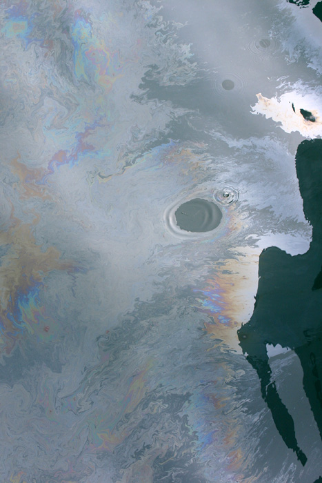
A fresh oil slick from the Deepwater Horizon spill, during June 2010.
Note that one drop of detergent was added to the oil slick, forming the cleared circle.
(Photo by David L. Valentine, University of California Santa Barbara)

From ScienceNews

Nearly 3 million liters [771,000 gallons] of a chemical dispersant ejected into oil and gas from BP’s
Deepwater Horizon oil spill last spring and summer lingered until at least September, a new study shows.
The chemicals moved in concert with plumes of oil deep beneath the Gulf of Mexico’s surface.

David Valentine
of the University of California, Santa Barbara and his colleagues periodically sampled plume water that flowed at depths of 1,000 meters or more between May and September 2010.
They shipped these samples to chemist
Elizabeth Kujawinski at the Woods Hole Oceanographic Institution in Massachusetts and her colleagues for analysis.

With rare exception, they report
online Jan. 26 in Environmental Science & Technology, the dispersant did not degrade but instead moved with the plumes until they were lost to dilution in the Gulf’s depths.

Breaking up is hard to do.
When oil and gas mixtures are ejected from a deep wellhead, liquid oil droplets of many different sizes form and rise toward the ocean surface.
Because the smaller droplets become as dense as the surrounding water deep below the surface--in this case at about 1,100 meters--they are swept away laterally by prevailing ocean currents (left panel).
When a dispersant is added at the depth of the wellhead, a component called a surfactant breaks up the oil into small droplets (middle panel).
If the dispersant works perfectly, virtually all the liquid oil is in these "neutrally buoyant" droplets and is carried away before ever reaching the surface and the droplets become small enough to be consumed, or "biodegraded," by bacteria.
In the Deepwater Horizon spill (right panel), scientists found evidence that the dispersant mixed with the small droplets in the deep-water hydrocarbon plume but also discovered the oil/dispersant mix had not yet biodegraded several months after the spill.
The study could not distinguish between oil droplets coated with surfactant (which would suggest the dispersant worked as planned) and surfactant floating freely on its own (suggesting the substance did not attach to the oil, as intended).
(Credit: Jack Cook, Woods Hole Oceanographic Institution)


“If the dispersant worked, it should have been associated with the liquid oil — that is, moving off laterally into the deep-water plume. Which is where we found it — and the only place,” Kujawinski says. “We did not see it below the plume or even sloughing off the top of it.”

To scout for the dispersant, known as Corexit 9500A, Kujawinski focused on an active ingredient known as DOSS, or dioctyl sodium sulfosuccinate.
It accounted for 10 percent by weight of the dispersant mixture, which was released at rates ranging from around 13,000 to 80,000 liters [3,400 to 21,000 gallons] per day.

Prior to capping the well, plume concentrations of DOSS hovered in the low-parts-per-million range, after which it diminished to parts-per-billion concentrations.
DOSS levels in the plume matched what would have been expected if the dispersants remained with the oil.
That, Kujawinski says, suggests no biodegradation of DOSS — and shows why remnants of dispersant applications could be detected 300 kilometers [186 miles] from the wellhead and even two months after their last application.

“When you read about Corexit, it’s supposed to biodegrade,” observes
Carys Mitchelmore of the University of Maryland’s Center for Environmental Science in Solomons.
But specific rates have not generally been reported, she adds. So the dispersant’s apparent persistence in the new paper is somewhat unexpected.

Then again, Mitchelmore notes, “Corexit is made up of multiple chemicals, so each might have different biodegradation rates.”
The aquatic toxicologist says she would like to see are data showing whether Corexit enhanced the ultimate breakdown of BP’s oil.

“The jury’s still out on the role of dispersants in oil degradation,” she says. “Some say they enhance it, others say they inhibit it.”

Like Mitchelmore, Beth McGee of the
Chesapeake Bay Foundation in Annapolis, Maryland., served on a 2005 National Academy of Sciences assessment of oil-spill dispersants.
Clearly, McGee says, undersea use in the Deepwater Horizon spill constitutes “uncharted territory.”

“Dispersants typically degrade fairly rapidly,” McGee says.
“So the new data leave me fairly surprised.”
And, she adds, the results suggest that novel uses — such as injecting them a mile below the surface where it’s cold and there’s no light — deserve study, if only to answer questions prompted by the BP spill.

Links :

Sunday, January 30, 2011

Follow your world : Email alerts for Google imagery updates


From Google LatLong

Follow Your World is a notification service for Google Earth/Google Maps satellite and aerial imagery updates.
You can register a location with the service and, if that location gets fresh imagery, Google sends you an e-mail alert.
(Requires a Google account)

Useful to follow user's feedback regarding shifts of imagery position for example
(see previous article regarding Bahamas charts)

Deep ocean creatures II/II


From BBC Blue Planet

This is the most unexplored area of the planet: the deep ocean.

It begins with a whale shark used as a shield by a shoal of bait fish to protect themselves from yellowfin tuna.
Also shown is an oceanic whitetip shark trailing rainbow runners.

Down in the ocean's furthest reaches, some creatures defy the classification.
On the sea floor, scavengers such as the spider crab bide their time, awaiting carrion from above.

The volcanic mountain chain at the bottom of the Atlantic Ocean also sustains life through the bacteria that surround its sulphide vents.
There are thought to be around 30.000 undersea volcanoes, some of them taller than mount Everest.
Their sheer cliffs provide anchorage for several corals and sponges. never the surface, the currents that surround these seamounts force nutrients up from below and thus marine life around them is abundant.

Ascension Island is a nesting ground for fritebirds and green turtles.
Off the mexican coast, a large group of sailfish feed on another shoal of bait fish, changing colour to signal their intentions to each other, allowing them to coordinate their attack.

The last sequence depicts the largest animal on Earth: the blue whale, of which 300 000 once roamed the world's oceans.

Now fewer than 3% remain.....