Thursday, November 25, 2010
Satellites reveal differences in sea level rises
From InsideScience
Glaciers are retreating and parts of the ice sheets on Greenland and Antarctica are melting into the ocean.
This must result in a rise in sea level, but by how much?
A new measurement of the gravity everywhere around the globe with a pair of orbiting satellites provides the first ever map detailing the rises across different parts of the globe.
According to the new results, the annual world average sea level rise is about 1 millimeter, or about 0.04 of an inch.
In some areas, such as the Pacific Ocean near the equator and the waters offshore from India and north of the Amazon River, the rise is larger.
In some areas, such as the east coast of the United States, the sea level has actually dropped a bit over the past decade.
The surface of the sea is a constantly shifting fabric.
To achieve a truer sense of how much the sea is changing in any one place, scientists measure the strength of gravity in that place.
Measuring gravity over a patch of ocean or dry land provides an estimate of how much mass lies in that region.
The measured mass depends on the presence of such things as mountains, glaciers, mineral deposits, and oceans.
If the gravity measurement for a place is changing, this could mean that the place is losing mass because of a retreating glacier or gaining mass if, as in the ocean surrounding Antarctica, new melt water is streaming in.
The Gravity Recovery and Climate Experiment, or GRACE for short, consists of a pair of satellites moving in an orbit that takes them over the South and North Poles.
The two craft, nicknamed Tom and Jerry after the television cartoon characters, send constant signals to each other to determine their relative spacing to about 10 microns -- one-tenth the width of a human hair -- over a distance of 130 miles.
If the first craft flies above a slightly more weighty area of the Earths' surface -- like a mountain range -- it will be tugged a bit out of place, an effect picked up by a change in the relative spacing of the craft.
In these way monthly gravity maps of pieces of land or ocean about 180 miles wide can be made with high precision.
The new report for the years of 2003-09 looks at how much mass has been lost from land areas and how much mass has been gained by ocean areas.
One of the authors of the report, Riccardo Riva from the Delft University of Technology in the Netherlands, said that average annual rise in sea level rise due to meltwater entering the ocean is about 1 millimeter, but that an additional rise will come from that fact that as the average temperature rises so does the ocean temperature, which in turn causes the volume of the ocean to increase.
"The most important result of the new report is the measurement of the sea level changes for specific regions of the Earth that are based on direct and global measurements of mass change," Riva said.
Mark Tamisiea, who works at the National Oceanography Centre in Southampton, England, and was not involved in the GRACE work, believes the new report represents good research.
"As coastal sea level changes impact society, it is important for us to understand as much about the local differences from the global average as possible," Tamisiea said. "These results are one piece in that puzzle."
"GRACE is definitely the 'real deal' when it comes from measuring climate change from space," said Joshua Willis, an ocean expert at the Jet Propulsion Laboratory in Pasadena, Calif. "This work by Dr. Riva and company reminds us that the world's oceans don't behave like a giant bathtub. As the ice melts and the water finds its way back to the ocean, the resulting sea level rise won't be the same all over the world."
"These effects are still small in today's rising ocean, but as we look out over the next century, the patterns of sea level change due to melting ice will be magnified many times over as the ice sheets thin and melt," Willis said.
Looking at the actual map of sea level rises presents an ironic twist. Offshore the areas where melting ice is most rapidly falling into the ocean -- such as Greenland and Antarctica -- the sea level appears to be falling.
"The main reason for this is the rebound of the solid Earth," explained Riva.
"Less ice causes the continents go up, and therefore sea level drops. Meltwater distributes around quite quickly, in most cases, so there is no accumulation due to that."
The new GRACE results appear in the journal Geophysical Research Letters.
Wednesday, November 24, 2010
Busy microbial world discovered in deepest ocean crust ever explored
From Oregon University
The first study to ever explore biological activity in the deepest layer of ocean crust has found bacteria with a remarkable range of capabilities, including eating hydrocarbons and natural gas, and “fixing” or storing carbon.
The research, just published in the journal PLoS One, showed that a significant number and amount of bacterial forms were present, even in temperatures near the boiling point of water.
“This is a new ecosystem that almost no one has ever explored,” said Martin Fisk, a professor in the College of Oceanic and Atmospheric Sciences (COAS) at Oregon State University. “We expected some bacterial forms, but the long list of biological functions that are taking place so deep beneath the Earth is surprising.”
Oceanic crust covers about 70 percent of the surface of the Earth and its geology has been explored to some extent, but practically nothing is known about its biology – partly because it’s difficult and expensive, and partly because most researchers had assumed not all that much was going on.
The temperature of the sediments and rock increases with depth, and scientists now believe that the upper temperature at which life can exist is around 250 degrees.
The ocean floor is generally composed of three levels, including a shallow layer of sediment; basalt formed from solidified magma; and an even deeper level of basalt that cooled more slowly and is called the “gabbro” layer, which forms the majority of ocean crust.
The gabbro layer doesn’t even begin until the crust is about two miles thick.
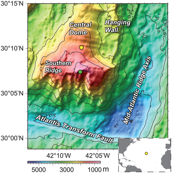
But at a site in the Atlantic Ocean near an undersea mountain, the Atlantis Massif, core samples were obtained from gabbro rock formations that were closer to the surface than usual because they had been uplifted and exposed by faulting.
This allowed the researchers to investigate for the first time the microbiology of these rocks.
A research expedition drilled more than 4,600 feet into this formation, into rock that was very deep and very old, and found a wide range of biological activity.
Microbes were degrading hydrocarbons, some appeared to be capable of oxidizing methane, and there were genes active in the process of fixing, or converting from a gas, both nitrogen and carbon.
The findings are of interest, in part, because little is known about the role the deep ocean crust may play in carbon storage and fixation.
Increasing levels of carbon dioxide, a greenhouse gas when in the atmosphere, in turn raise the levels of carbon dioxide in the oceans.
But it now appears that microbes in the deep ocean crust have at least a genetic potential for carbon storage, the report said.
And it may lend credence to one concept for reducing carbon emissions in the atmosphere, by pumping carbon dioxide into deep subsurface layers where it might be sequestered permanently.
The researchers also noted that methane found on Mars could be derived from geological sources, and concluded that subsurface environments on Mars where methane is produced could support bacteria like those found in this study.
“These findings don’t offer any easy or simple solutions to some of the environmental issues that are of interest to us on Earth, such as greenhouse warming or oil spill pollution,” Fisk said. “However, they do indicate there’s a whole world of biological activity deep beneath the ocean that we don’t know much about, and we need to study.”
Microbial processes in this expansive subseafloor environment “have the potential to significantly influence the biogeochemistry of the ocean and the atmosphere,” the researchers wrote in their report.
The research was supported by the National Science Foundation, U.S. Department of Energy, Gordon and Betty Moore Foundation, and the Integrated Ocean Drilling Program. Collaborators were from OSU, the Lawrence Berkeley National Laboratory, Tohoku University in Japan, Universitat Bremen in Germany, University of Oklahoma, and National Institute of Advanced Industrial Science and Technology in Japan.
Links :
- Descent to Mid-Atlantic Ridge expedition (2000)
- NOAA : the Western Massif
- Lost City Research : one of the most extreme environment on Earth
Tuesday, November 23, 2010
More than a million Atlantic sharks killed yearly
At least 1.3 million sharks, many listed as endangered, were harvested from the Atlantic in 2008 by industrial-scale fisheries unhampered by catch or size limits, according to a tally released Monday
The actual figure may be several fold higher due to under-reporting, said the study, released by advocacy group Oceana on the sidelines of a meeting of the International Commission for the Conservation of Atlantic Tunas (ICCAT)
Convening in Paris through November 27, the 48-member ICCAT is charged with ensuring that commercial fisheries are sustainable. It has the authority to set catch quotas and restrictions.
While the global spotlight has been trained on the plight of Atlantic bluefin tuna, many species of high-value sharks are in even more dire straits, say marine biologists.
"Sharks are virtually unmanaged at the international level," said Elizabeth Griffin Wilson of Oceana. "ICCAT has a responsibility to protect our oceans' top predators."
Under the UN Convention on the Law of the Sea, "highly migratory" sharks must be managed by international bodies.
Of the 21 species found in the Atlantic, three-quarters are classified as threatened with extinction.
North Atlantic populations of the oceanic white tip, for example, have declined by 70 percent, and hammerheads by more than 99 percent, according to the International Union for the Conservation of Nature (IUCN).
Other species -- including the porbeagle, common thresher and shortfin mako -- have also been overexploited, and may be teetering on the brink of viability.
Many are fished for their fins -- prized as a delicacy in Chinese cuisine -- and then tossed, dead or dying, back into the sea once the choice morsels have been sliced off.
The practice is prohibited, but loopholes in the regulation have allowed the ban to be widely ignored.
Oceana and several conservation groups, backed by some governments, have called upon ICCAT to set catch quotas and other protective measures for these and other vulnerable sharks.
The United States has proposed requiring that all sharks be brought back to shore whole, which would boost enforcement of the finning ban and help scientists measure population levels.
Japan -- which quashed a drive earlier this year to protect four threatened shark species under the UN Convention on International Trade in Endangered Species (CITES) -- is now urging ICCAT to prohibit fishing one of them, the oceanic white tip.
The initiative "is an example showing our commitment for conservation of shark resources," the head of the Japanese delegation said in an opening statement.
Sharks have reigned at the top of the ocean food chain for hundreds of millions of years.
But the consummate predators are especially vulnerable to industrial-scale overfishing because they mature slowly and produce few offspring.
"The classic fisheries management approach of 'fishing down' a given population to its so-called maximum sustainable yield, and then assuming it can recover, does not work for sharks," said Matt Rand, a shark expert at the Washington-based Pew Environment Group.
Tens of millions of the open-water hunters are extracted from global seas every year.
Regional studies have shown that when shark populations crash the impact cascades down through the food chain, often in unpredictable and deleterious ways.
Links :
- WashingtonPost : Migratory sharks face intense fishing pressure
- WorldFishing : Shark campaigners, ICCAT action needed
- HuffingtonPost : Pew Environment Group, shark attack survicors fight for shark conservation
- GeoGarage blog : Shark-finning puts species on verge of extinction
Monday, November 22, 2010
Bottom of the water
''One touch of nature makes the world Kin'' W. Shakespeare
Héen Tàak is a documentary exploring the wilderness of Alaska’s Inner Passage.
A discovery of the edge of glaciers at the bottom of the ocean among men and women who fully live their philosophy of love and respect in an intimate privileged relationship with water.
The wilderness offers unique and surprising wonders, above and under water, revealing a host of fascinating species.
Héen Tàak, ("Bottom of the water" in Tlingit langage.) the new film by the awards winning director Nathalie Lasselin (2010 Best of Alaska award. Alaska international film festival)
Sunday, November 21, 2010
Hurricane forecasts can be made years in advance
From Wired
The parade of storms that pummels the western fringe of the North Atlantic every year just got a bit more predictable.
Scientists say they have developed a way to forecast how many Atlantic hurricanes there will be — not just for the upcoming year, as some groups already do each spring, but for several years out.
“This is the first time anyone has reported skill in predicting the number of hurricanes beyond the seasonal time scale,” says Doug Smith, a climate modeler at the Met Office Hadley Centre in Exeter, England.
A paper by Smith and his colleagues appeared online Nov. 7 in Nature Geoscience.
Knowing how hurricane trends could change in the future, he says, will help society prepare for the damage of the kind that Hurricane Tomas recently dealt the Caribbean.
Atlantic hurricane activity waxes and wanes over a cycle of several decades, and since 1995 has been in an active part of that cycle.
Researchers have been working to tease apart the causes of this cycle and to predict how future changes, like rising sea-surface temperatures, might affect storms.
Smith’s team uses one of the hottest areas of climate modeling: decadal climate prediction, which aims to understand both how the climate system varies internally, along with external factors like greenhouse gases and volcanic eruptions.
The researchers used nine versions of its decadal prediction model to “hindcast” Atlantic hurricanes each year from 1960 to 2007.
The model was set to May 1 for each of those years and then was asked how many storms would come that season.
Averaging across the nine versions, the model results closely matched the changing number of hurricanes that occurred over those decades. Smith says: “We’ve found that there is some skill there.”
Next the team tackled long-term predictions, by starting on Nov. 1 of each year between 1960 and 2005 and forecasting the number of hurricanes for 10 years out.
Again, Smith says, the model tracked the observations well, particularly within the first couple of years.
But the study can’t yet show exactly what makes hurricanes more frequent.
Climate researchers disagree over whether past increases in hurricane activity were due to internal variability, external factors like greenhouses gases, or both.
By watching how well the model matches reality while changing these factors, Smith’s team suggests that at least some of the recent increase in Atlantic hurricane frequency comes from external factors.
The next step, Smith says, is to run more comparisons and see which of those might be most important.
Many researchers think that global warming will indeed affect how many storms form.
If atmospheric carbon dioxide levels double over preindustrial levels by the year 2100 as many expect, “we should expect an increase in the frequency of the strongest hurricanes in the Atlantic, roughly by a factor of two by the end of the century,” says a group led by modeler Morris Bender of NOAA’s Geophysical Fluid Dynamics Laboratory in Princeton, New Jersey. Their analysis appeared in Science in January.
Within the next few months, Smith’s team plans to forecast how many Atlantic hurricanes there will be over the next few years.
So far this season the Atlantic has had 20 named storms, 12 of them hurricanes.
That’s in line with NOAA’s May forecast, which called for 14 to 23 named storms, of which 8 to 14 would be hurricanes.
The Atlantic hurricane season ends Nov. 30.
Links :
- Marine GeoGarage blog
Subscribe to:
Posts (Atom)