Here is a clear, structured, and comparative summary of the two major technical studies that provided the framework for Lebanon's southern maritime delimitation:
2. The study by the Lebanese Armed Forces (LAF) Hydrographic Office
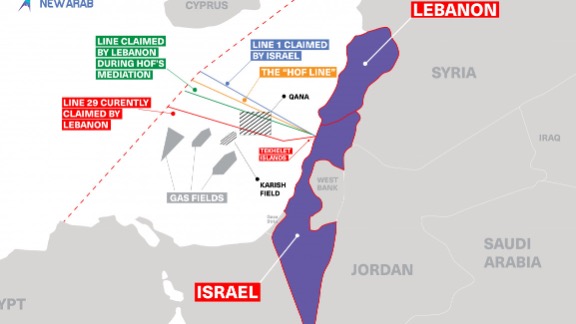
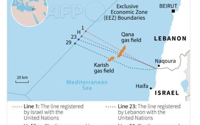
This is the key to understanding the origin of the discrepancies between “Point 1” chosen in 2007 and “Line 23/Line 29” claimed later.
Mandate entrusted by the Siniora government to assist Lebanon in preparing a maritime delimitation in accordance with international law.
UKHO objective
• Determine a fair line in accordance with UNCLOS (Articles 15, 74, 83).
• Select relevant baselines on the Lebanese coast.
• Propose a technically defensible line for the EEZ declaration.
UKHO method
• High-resolution coastline analysis (orthophotos + UK Admiralty nautical charts).• Selection of base points according to:
o natural projections ,
o absence of artificial disturbances (dikes, ports, artificial beaches, etc.).
UKHO conclusion: two options
UKHO presented two possible routes to the Lebanese government:
Option A — Line 23 (considered “conservative”)
• Based on less aggressive basepoints closer to the coast.
• Represents a moderate version that is less politically contentious .
• Implies a loss of approximately 860 km² compared to the interpretation most favorable to Lebanon.
Option B — Line 29 (considered “legally defensible”)
• Based on the most advanced and geometrically correct base points.
• Strictly follows the principle of equidistance unaffected by coastal distortions.
• Gives Lebanon ≈ 1,430 km² of additional EEZ compared to Line 23.
• Recognized by UKHO engineers as legally sound under UNCLOS.
➡ UKHO has clearly stated that Line 29 is defensible, but the political decision rests with Lebanon.
2. Lebanese Army Study (2011–2020)
Conducted by the Lebanese Armed Forces Hydrographic Office (LAF) + geodesy experts.
Army objective
• Verify the validity of the line submitted to the UN (Line 23).
• Determine whether a more favorable route exists under maritime law.
• Correct the errors made in 2007 during the Lebanon–Cyprus agreement.
Main conclusion of the army
1. “Point 1” chosen in 2007 is incorrect.
• Lebanon accepted a point artificially moved northward ,
• not located on the actual land border ,
• contrary to the requirements of UNCLOS, which stipulates that the EEZ must begin from the undisputed land border .
Consequence:
➡ This shift reduces Lebanon's projection angle towards the sea → loss vis-à-vis Israel and vis-à-vis Cyprus (geometric domino effect).
• Military engineers demonstrate that the actual Lebanese base points (natural rock, no quay, no sand deposits) allow for a much more advantageous route.
• Line 29 is strictly compliant with undistorted equidistance.
• Supported by:
o UKHO charts,
o high-precision orthophotos.
Technical conclusion of the army:
➡ Lebanon is entitled to ≈ 1,430 km² more than indicated in its official declaration (Line 23).
• Decree 6433, which freezes line 23, should have been amended.
• The army prepared the technical documents for correction.
• But the government (Aoun–Diab then Mikati) never signed it, despite full technical support.
Comparison between UKHO and the Lebanese Army
Criterion UKHO Lebanese Army (LAF)
Objective Provide options in accordance Determine the actual line according with the law to UNCLOS
Politically accepted route Line 23 Rejected – proposes Line 29
Baseline analysis Technical + political caution Strictly technical
Position on Line 29 Legally defensible Legally binding
Position on Point 1 No political decision Confirms that Point 1 2007 is incorrect
Consequence Loss of 860 km² compared to optimum Cumulative loss of 1,430 km² if not corrected
✔ UKHO provided two solutions:
• Line 23: politically prudent
• Line 29: technically correct and defensible
✔ The Lebanese army confirmed that:
• Point 1 of 2007 is incorrect ,
• Line 23 is suboptimal,
• Line 29 is the only one that complies with international maritime law.
✔ By not claiming Line 29 at the UN,
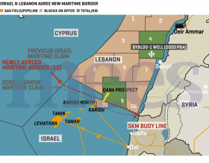
Lebanon automatically lost its ability to claim the 1,430 km² — which Israel then exploited in the 2022 negotiations.
 Lebanon’s losses could exceed 5,000 km² of its exclusive economic zone.
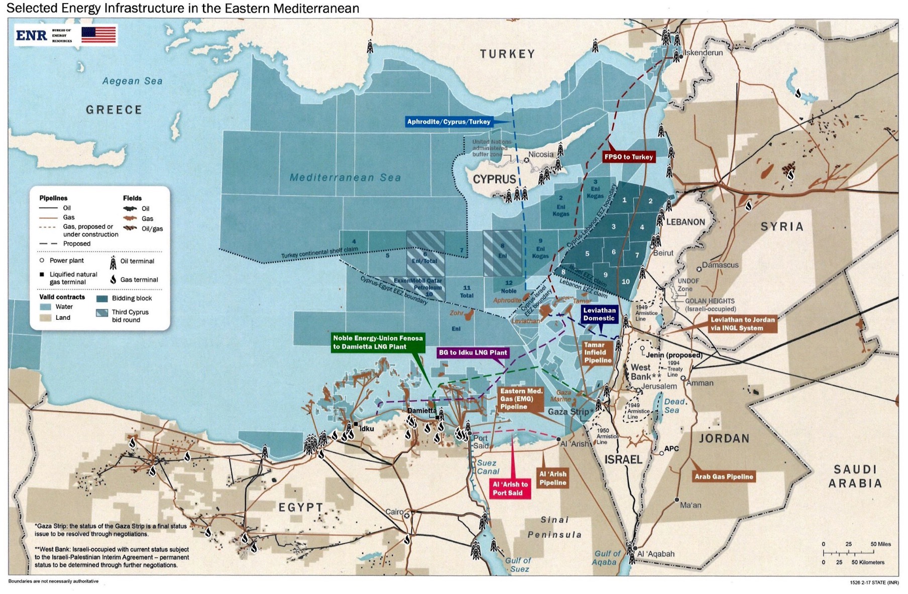
Lebanon is located at a strategic crossroads, both geopolitically and in terms of energy.
A legally defensible optimal line
The famous “Line 29” corresponded to the exact projection of the land border between Lebanon and Israel onto the sea.
So why was this option not adopted?
The Israeli factor and international pressure
Externally, an ambitious claim would have almost automatically triggered tensions with Israel, which disputes this area.
Beyond the fear of conflict, the decision reflects a strategic calculation: Lebanon was not yet ready to fully exploit its gas and oil resources.
Consequences of this choice
Point 1, currently adopted by Lebanon, was defined by former Prime Minister Fouad Siniora in 2007 and has since been confirmed by successive presidents: Michel Sleiman (map of Line 23 sent to the UN), Michel Aoun (signs an agreement with Israel based on Line 23), Joseph Aoun, and Speaker of the House Nabih Berri.
• Moving Point 1 even a short distance along the coastline changes the position of the median lines because the equidistance rule is calculated based on these originals.
• When the median line shifts in favor of the neighbor (Israel, then Cyprus), the lost area is added: a loss to Israel can, depending on the angle/direction, alter the line of intersection with the Cyprus area and further reduce the available Lebanese surface area—hence the domino effect.
• In practice (on the actual map), these losses can amount to hundreds or even thousands of square kilometers depending on the actual geometry of the coastline and the precise location of the base points — hence the major strategic issue.
The first shock came from the map sent to Cyprus: more than 3,000 km² of potentially resource-rich maritime space was conceded without solid justification.
Israel, observing this Lebanese laxity, recalculated its own strategy.
Caught in this spiral, the country is witnessing a continuous erosion of its maritime space.
The paradox is all the more striking given that the justification invoked for years—the need to move quickly to exploit gas and oil—does not hold up in the face of reality on the ground.
The result: everything is blocked.
Webography:
Who is the UKHO?
What the UKHO has done for Lebanon
• At the request of the Lebanese government, the UKHO conducted an assessment study of the maritime delimitation made in 2009 (in particular the proposed EEZ line). LCPS+2Ici Beyrouth+2
• In its report, the UKHO proposed two options for Lebanon's southern maritime border. The second — known as “line 29” — would have granted Lebanon approximately 1,430 km² more than the line used until then (the “line 23”). LCPS+2The National+2
Why it matters (and why it's controversial)
• Had Line 29 been adopted, it would have given Lebanon a significantly larger maritime zone — which is crucial for its rights to explore offshore resources (gas, oil, etc.). Fondation pour la Recherche Stratégique+2Orient XXI+2
• But—despite this recommendation—the government never officially submitted line 29 to the United Nations. Instead, in 2011, Lebanon issued a decree (Decree 6433) reiterating line 23 as its official position. The Policy Initiative+2LCPS+2
• Some Lebanese experts and military officials believe that this omission deprived the country of hundreds—even thousands—of square kilometers of potential territory, fueling controversy in maritime negotiations with Israel. Orient XXI+2American University of Beirut+2
Conclusions & current status
• The UKHO's work provides the technical and cartographic basis on which Lebanon can base its maritime claims.
• However, the extension recommendation (line 29) has never been officially adopted — which has reduced the country's weight in negotiations.
• Today, maritime delimitation remains a strategic issue for the exploitation of Lebanon's offshore resources (gas, oil)—and the UKHO's work remains a frequently cited reference point in debates.
Here is a realistic geographical diagram — based on publicly available maps — illustrating the difference between the “line 29” claim and the line officially adopted for Lebanon's sea/EEZ in relation to Israel (and — relevantly — the area of Cyprus).
Visible data & issues
- GeoGarage blog : Israel and Lebanon negotiate their maritime border
- Tehran Times : How Nawaf Salam’s cabinet is handing maritime resources to Israel!
- Al Akhbar : US Grip Threatens to Hand Cyprus 5,000 km² of Lebanon’s Resources
- NYTimes (2022) : Israeli-Lebanese Maritime Deal Marks a Milestone, With Limitations
No comments:
Post a Comment