
Map of the Territorial Sea of the Republic of Albania [scale not given].
Source: A. Meçollari, UNCLOS 1982 and the baseline of the Republic of Albania,
QKSM, Tirana, 2014, p. 27.
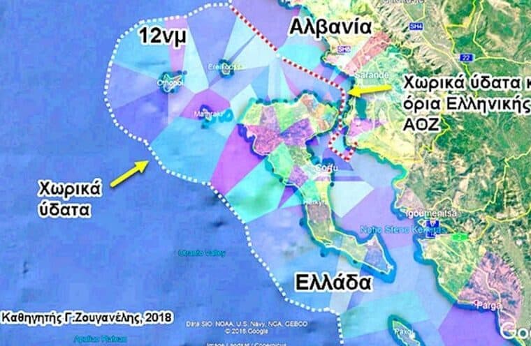
From Panorama by Captain First Rank, Artur Meçollari, has explained the map of the maritime border division between Albania and Greece in the Ionian Sea, if the right to expand by 12 miles were to be applied.
In an interview with the newspaper "Panorama", Meçollari indicated that the application of this principle, which stems from the Montego Bay Convention, can only be done in cases where the distance of the coasts between two countries is more than 24 miles.
According to the former deputy commander of the Navy, the border of the territorial sea cannot go beyond the delimitation line of the neighboring country, opposite or adjacent.
Illustrating the map he made for the newspaper "Panorama"", Meçollari says that if Greece were to apply the 12 nautical miles in dividing the maritime border with Albania, then it would also take the entire district of Saranda and not just the sea.
Also, according to him, Albania, on the other hand, with the application of 12 miles would go to the middle of the island of Corfu.
Because the coasts between Albania and Greece are for the most part less than 24 miles apart, Meçollari says that the definition of the delimitation line between the two countries can only be done by an agreement, using the median line as the principle for dividing territorial waters.
According to Captain Artur Meçollari, the only case when a country's territorial sea can violate the delimitation line is when the two countries make an agreement to do so.
Further, in his interview, he says that this entire issue that has arisen in the last week is more related to Greek domestic politics, but also to the growing tensions of the last month with Turkey, precisely over the division of the maritime border in the eastern part of the Aegean Sea, but also of the Mediterranean.
There is widespread talk and concern about the expansion of Greece's territorial sea by 12 nautical miles in the Ionian Sea.
What does the UN Convention on the Law of the Sea say about this issue?
I consider the citizens' concerns legitimate.
Of course, they have the right to be concerned about the fate of their country.
The history of Albania over the last 100 years, but also the maritime agreement with Greece in 2009, overturned by the Constitutional Court, teaches us that we must be vigilant, professional and oriented towards the national interest.
Today, fortunately, there is a decision of the Constitutional Court on this issue, guiding and binding for all.
The UN Convention on the Law of the Sea, or as it is known, UNCLOS 1982, was opened for signature in Montego Bay, Jamaica, on 10 December 1982.
It was the product of 13 years of work by representatives of almost all UN member states.
UNCLOS 1982 entered into force on 16 November 1994 and today, most UN member states are parties to it.

Of course, there are states that have not ratified it, such as the US and Turkey, but it is already in force.
Article 3 of UNCLOS 1982 gives any coastal state the right to declare the width of the territorial sea, but not more than 12 nautical miles, this measured from the baseline, which can be normal (the seashore), straight (which in everyday jargon is an imaginary line that joins the most protruding capes on the coast) and combined (with both methods).
The expansion of the width of the territorial sea causes the displacement of the "external limit of the territorial sea", which according to Article 4 of UNCLOS 1982 is an imaginary line equidistant from the baseline, equal to the width of the declared territorial sea.
The outer limit of the territorial sea limits it to the international sea and not to the national seas of neighboring states, on the side or opposite.
This means that the extension of the territorial sea can be made to those geographical areas where the coastline of the neighboring state, on the side or opposite, is greater than 24 nautical miles and this extension is made by declaration by the coastal state.

This declaration by Greece to expand its territorial sea to 12 nautical miles is being interpreted as an expansion of Greek waters towards Albanian waters...
This is not possible.
UNCLOS 1982 is clear on this.
According to its article 15, the extension of the territorial sea beyond the delimitation line is not allowed.
For this, the article states that “neither State shall have the right …… to extend its territorial sea beyond the median lines, the points of which are equidistant from the nearest points of the baselines from which the breadth of the territorial sea of the two States is measured”.
However, the Convention in this same article allows the coastal State to extend its territorial sea beyond this line “except when an agreement has been made between them”, i.e.
not unilaterally, as Article 3 of UNCLOS 1982 provides for the extension of the territorial sea.
Article 15 makes this provision when the States decide of their own free will and by agreement to exchange the areas of their respective territorial seas beyond the delimitation line.
This exchange may occur to create access for a coastal state without access to the international sea (Croatia-Slovenia case) or for other reasons.
Slovenia does not have free access to the international sea and its military, but also non-military, ships must pass through the territorial sea of Croatia or Italy.
In these circumstances, Slovenian ships must pass in accordance with the regime of innocent passage.
When there is a threat to national security, coastal states enjoy the right to temporarily and non-discriminatory suspension of innocent passage for military, but also non-military ships.
In order to avoid such situations and to guarantee the freedom of navigation and operational mobility of its military ships, Slovenia has requested to make compensation of territorial seas with Croatia, creating a free corridor through the territorial sea of Croatia.
This dispute has been ongoing for 25 years.
Although Slovenia won the case in the Court of Arbitration, Croatia has decided not to implement the decision.
If this is clear, why all this misunderstanding?
UNCLOS 1982 is a complex and voluminous international legal framework.
It is written in narrative form, but when issues of defining maritime spaces (by declaration or delimitation) are addressed unilaterally, by agreement or court decision, they turn into imaginary lines on the sea, often also required with geographical coordinates.
The recognition and implementation of this convention is not simply a legal issue, but also requires maritime knowledge and culture.
The geometry of maritime spaces is complex.
Maritime spaces in many cases, although representing different legal regimes, overlap from a geographical point of view in a three-dimensional space.
All maritime spaces of the coastal state are measured or delimited by the baseline, which has a fundamental impact.
Pragmatist interpretation of the provisions of UNCLOS 1982 on the straight baseline brings benefits to the coastal state.
Paradoxically, in January 2008, in the midst of negotiations, Law No.
8771 “On the State Border in the Republic of Albania” was repealed and, consequently, the straight baseline of Albania.
Albania willingly changed the rules in the middle of the game, causing significant damage to Albania in the 2009 agreement.
The straight baseline of Albania, constructed in 1970, modified in 1976 and deposited with the UN in 1990, is one of the most accomplished scientific products of maritime specialists and lawyers in Albania.
Below I have presented an illustrative scheme, which should not be considered a map for delimitation purposes.
If we were to assume that the expansion of the width of the territorial sea extends beyond the delimitation line, the following scheme explains this.
The scheme shows how the territorial sea of Greece would extend (12 nautical miles) starting in the middle of the Gulf of Borsh and including the entire District of Saranda.
While Albania would extend (12 nautical miles) including almost the largest part of the northern part of the island of Corfu.
This scheme proves that in no case, the extension of the territorial sea, declared unilaterally by the coastal state, can extend beyond the delimitation line of the territorial sea.
The previous negotiating group claims that during the negotiations they had taken into account the width of Greece's territorial sea of 6 nautical miles.
What is the truth?
As I explained, the width of the territorial sea does not affect the determination of the delimitation line of the territorial seas between two states.
This is because the delimitation line is a line equidistant from the respective coasts, modified for special circumstances or historical titles as the case may be.
Territorial seas are delimited up to a distance of 12 nautical miles from the coasts of both states, regardless of the declared width of the territorial seas.
This is expressed in UNCLOS 982, but also in international practice, in order to allow states to change the width of the territorial sea at will, without violating the agreements reached.
In 2009, the delimitation line between Albania and Greece of the territorial sea was determined up to a distance of 12 nautical miles from the two coasts, which corresponded to point 139 of the agreement line.
When that agreement was drafted, Greece had declared the width of the territorial sea to be 6 nautical miles and Albania to be zero nautical miles.
Regardless of the methodology used, this ratio of the latitudes of the territorial seas determined a delimiting line, unaffected by these latitudes.

SCHEME, HOW MARITIME BORDERS ARE DIVIDEDMaritime boundaries and their delimitation are internationally regulated by the UNCLOS Convention of Montego Bay in 1982.
It has been ratified by most member states of the United Nations Organization.
The only exceptions are the USA and Turkey, which have not ratified this Convention.
It has been ratified by most member states of the United Nations Organization.
The only exceptions are the USA and Turkey, which have not ratified this Convention.
How does the declaration of the width of Greece's territorial sea affect relations with Turkey?
The expansion of the breadth of the territorial sea, as long as it is done in accordance with the provisions of UNCLOS 1982, is a matter of the internal will of the coastal state.
Unlike the Aegean Sea, for the expansion of the breadth of the territorial sea in the Ionian and Central Mediterranean, as far as I know this issue, no restrictions are foreseen by the 1931 treaty.
The question is what is Greece's goal with this expansion: to give up its claims for expansion in the Aegean Sea, or to postpone this objective for a while? I am convinced that regardless of what Greece intends, the maritime regime in the Aegean Sea will be part of the agenda of the upcoming talks with Turkey on the maritime regime in the Eastern Mediterranean.
However, Greece's claims for expansion in the Ionian and Eastern Mediterranean are its relationship with international law.
Do the maritime disputes between Turkey and Greece have an impact on the work of the negotiating group?
One of the basic principles of international law is that agreements between states should not infringe on the interests of other states.
The future agreement should be neutral regarding the disputes that different states have with each other.
The mistake made in the 2009 agreement should not happen again.
This fact was also evidenced in the decision of the Court of Justice, which also considered Article 2 of the agreement problematic in relation to the Constitution.
In the 2009 agreement, the title of the agreement concealed the essence of the agreement, highlighting the delimitation of the continental shelf, while about 80% of the delimitation line was for the territorial sea.
Also, Article 2 of the agreement determined the legal regime of the parties beyond the delimitation line.
The jurisdiction of states in maritime spaces, beyond the delimitation lines, is a relationship between the coastal state and international law.
The title of the agreement reached in 2009, combined with Article 2, was essentially an interference in the interests of other parties (direct or indirect) with a bilateral agreement.
Links :
- Panorama : The issue of the sea/ Expert speaks: If Greece expands by 12 miles to the north of the Ionian Sea, Albania should oppose it at the UN. Why should we demand the implementation of the principle of… / Sea Agreement with Greece, expert: Here's how much territory Albania loses from 12 nautical miles
- GreekCity Times : Extension of territorial waters to 12 nautical miles in the Ionian Sea ratified
- GeoGarage blog : Maritime Spatial Planning : Opportunity for Greek-Turkish ... / Turkey-Greece tensions: eastern Mediterranean claims in ... / The Messy Mediterranean / Where to draw the line in the Eastern Mediterranean /
No comments:
Post a Comment