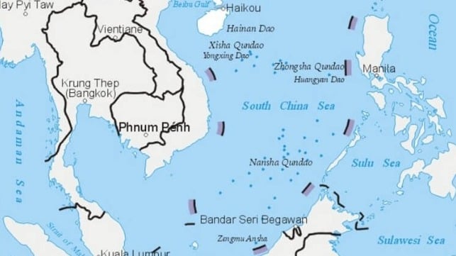
 China's nine-dash line surrounds most of the South China Sea,
including the Spratly and Paracel Islands
(China Ministry of Natural Resources)
From Maritime Excutive
On Tuesday, China released the results of a new geological survey of the South China Sea, and claims to have named nearly 400 subsurface features throughout the water body.
Beijing claims sovereignty over almost all of the South China Sea, including large swathes of its neighbors' exclusive economic zones. Its sweeping maritime claims were invalidated by the Permanent Court of Arbitration in the Hague in 2016, but China has ignored the ruling.
Yang Chupeng, an official with the Guangzhou branch of the China Geological Survey, told state media that the new survey results will "provide good services for our country's marine engineering construction." The survey data will facilitate the "development and protection" of "China's blue land," the agency said.
Ministry of Natural Resources announced in 2020 some seabed geographical entities
in the East China Sea
A territorial row between China and Japan appears to be escalating.

China has announced new names for some 50 underwater geological features around disputed islands in the East China Sea.
Some of the names include the term "Diaoyu" -- the Chinese name for the island group.
This comes a day after a local assembly in Japan approved plans to rename the area covering the islands.
The Japanese term for the islands -- "Senkaku" -- will be used in the new administrative name.
China has slammed the move as illegal.
The islands are currently controlled by Japan.
The survey process found 36 new seabed features that were previously unmapped, according to state media.
The study also gave state officials the opportunity to give new names to 384 seabed landforms around the South China Sea.
The right to name seabed features is consistent with China's position on the South China Sea's ownership.
The right to name seabed features is consistent with China's position on the South China Sea's ownership.
Beijing has long claimed that it has “indisputable sovereignty over the islands in the South China Sea and the adjacent waters," including legal jurisdiction over the surface, seabed and subsurface mineral rights.

Chinese Research ship described as a "dual use spy ship"
(Wang Yuan 5 ballistic missile tracking sea surveillance ship)
The data also has military applications.
Fine-scale subsea mapping is useful for submarine warfare, as seabed features must be carefully mapped to safely navigate a sub near the bottom.
(Subs can and do collide with unmapped promontories.)
Seabed features can also be used to conceal a sub from detection.
The Washington-based Center for Strategic and International Studies recently published a summary of evidence that China's research vessels serve military purposes, like the research vessels of other naval powers.
The Washington-based Center for Strategic and International Studies recently published a summary of evidence that China's research vessels serve military purposes, like the research vessels of other naval powers.
CSIS asserts that of the 64 active Chinese research vessels, over 80 percent demonstrate suspect behavior or possess links suggesting involvement in Beijing’s geopolitical agenda.
The Ministry of Natural Resources and Chinese Academy of Sciences both operate research vessels and have signed cooperation agreements with China's military. The China Geological Survey, which sponsored the large-scale mapping effort, is a division of the Ministry of Natural Resources.
The Ministry of Natural Resources and Chinese Academy of Sciences both operate research vessels and have signed cooperation agreements with China's military. The China Geological Survey, which sponsored the large-scale mapping effort, is a division of the Ministry of Natural Resources.
Links :
- RFA : China Names 50 New Undersea Features in East China Sea (2020) / South China Sea Surveys Pressure Claimants, Mine Info With Military Use
- Hindustan Times : China renames five seabed features in Indian Ocean Region (2023) / Xi Jinping projects dominance in Indian Ocean, names 19 sea bed features
- CRS : China-Philippines tensions in the South China Sea
- CSIS : Deep blue scars (Environmental threats to the South China Sea) / Surveying the seas (China's dual-use research operations in the Indian Ocean
No comments:
Post a Comment