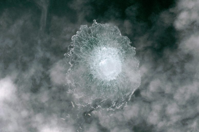
This high-resolution image, captured by Pléiades Neo, shows the Nord Stream gas pipeline leak seen on September 29.
Credit: Pléiades Neo
Satellite
monitors discovered two vessels with their trackers turned off in the
area of the pipeline prior to the suspected sabotage in September.
The first gas leaks on the Nord Stream 2 pipeline in the Baltic Sea were detected in the early hours of September 26, pouring up to 400,000 tons of methane into the atmosphere.
Officials immediately suspected sabotage of the international pipeline.
New analysis seen by WIRED shows that two large ships, with their trackers off, appeared around the leak sites in the days immediately before they were detected.
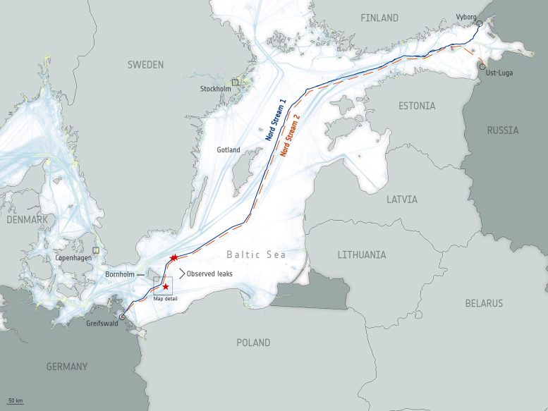
This map shows the pair of Nord Stream natural gas pipelines that runs under the Baltic Sea from Russia to Germany.
It comprises the Nord Stream 1 pipeline running from Vyborg in northwest Russia, near Finland, and the Nord Stream 2 pipeline running from Ust-Luga in northwest Russia near Estonia.
Ship traffic in the map can be identified as blue and yellow lines and uses data from the European Marine Observation and Data Network (EMODnet).
Red stars in the image depict the observed leaks as detected by the Copernicus Sentinel-1 mission.
Credit: ESA
According to the analysis by satellite data monitoring firm SpaceKnow, the two “dark ships,” each measuring around 95 to 130 meters long, passed within several miles of the Nord Stream 2 leak sites.
“We have detected some dark ships, meaning vessels that were of a significant size, that were passing through that area of interest,” says Jerry Javornicky, the CEO and cofounder of SpaceKnow.
“They had their beacons off, meaning there was no information about their movement, and they were trying to keep their location information and general information hidden from the world,” Javornicky adds.
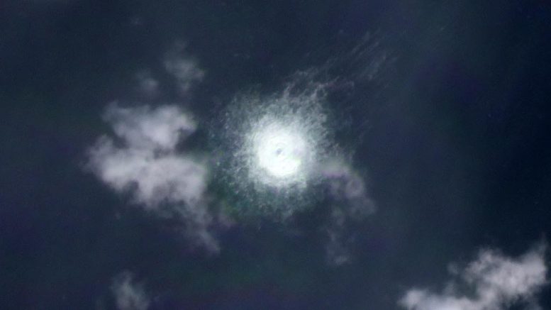
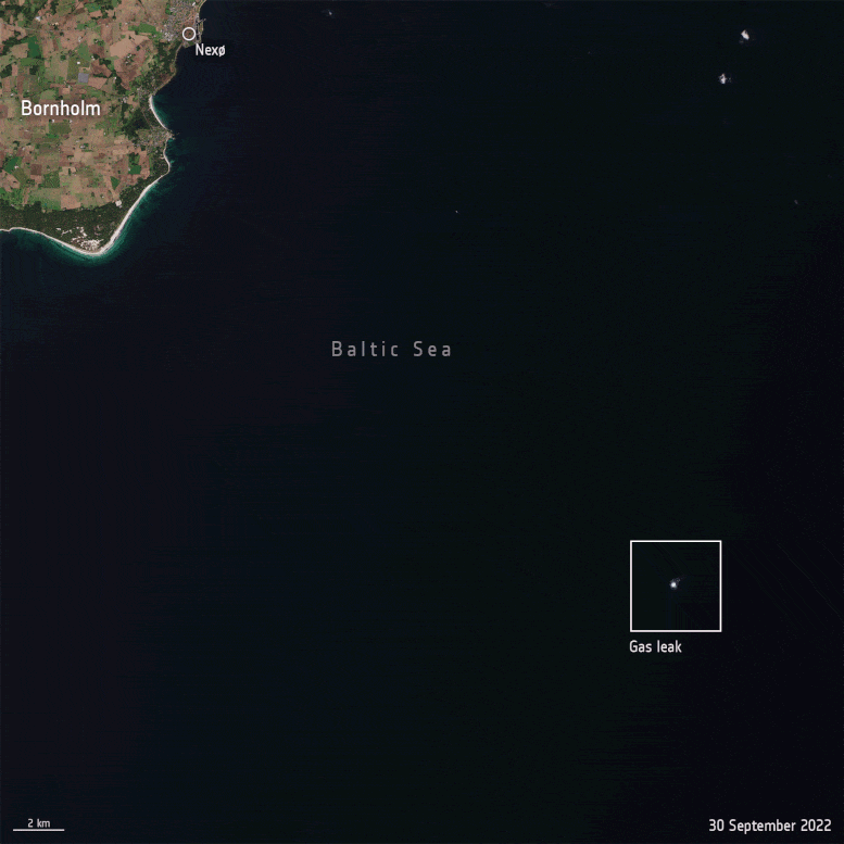
On September 26, Planet satellites captured an image of the Nord Stream Gas pipeline rupture in the Baltic Sea, approximately 20 km southeast of Bornholm Island, Denmark.
Credit: Planet Labs PBC
The discovery, which was made by analyzing images from multiple satellites, is likely to further increase speculation about the cause of the blasts.
Multiple countries investigating the incident believe the Nord Stream 1 and 2 pipelines were rocked by a series of explosions, with many suspicions directed at Russia as its full-scale invasion of Ukraine continues.
(Russia has denied its involvement.) Once SpaceKnow identified the ships, it reported its findings to officials at NATO, who are investigating the Nord Stream incidents.
Javornicky says NATO officials asked the company to provide more information.
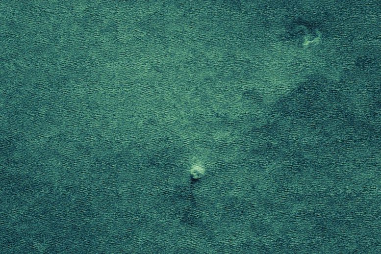
This radar image was captured on September 28 by ICEYE— the first New Space company to join the Copernicus Contributing Missions fleet.
Credit: ICEYE 2022
NATO spokesperson Oana Lungescu says it does not comment on the “details of our support or the sources used” but confirmed that NATO believes the incident was a “deliberate and irresponsible act of sabotage” and it has increased its presence in the Baltic and North Seas.
However, a NATO official, who did not have permission to speak publicly, confirmed to WIRED that NATO had received SpaceKnow’s data and said satellite imagery can prove useful for its investigations.
However, a NATO official, who did not have permission to speak publicly, confirmed to WIRED that NATO had received SpaceKnow’s data and said satellite imagery can prove useful for its investigations.
The animation shows the gas leak as captured by the Copernicus Sentinel-2 mission on September 30, 2022, compared to the acquisition on October 3 where no gas leak is visible.
Credit: Contains modified Copernicus Sentinel data (2022), processed by ESA, CC BY-SA 3.0 IGO
To detect the ships, Javornicky says, the company scoured 90 days of archived satellite images for the area.
The company analyzes images from multiple satellite systems—including paid and free services—and uses machine learning to detect objects within them.
This includes the ability to monitor roads, buildings, and changes in landscapes.
"We have 38 specific algorithms that can detect military equipment," Javornicky says, adding that SpaceKnow’s system can detect specific models of aircraft on landing strips.
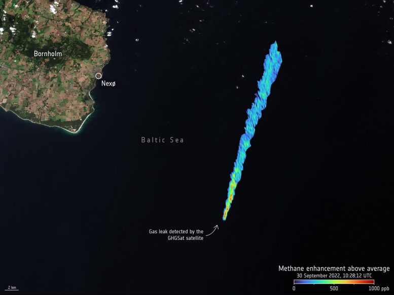
In response to the gas leak, GHGSat, a leader in methane emissions monitoring from space and also part of ESA’s Third Party Mission Program, tasked its satellites to measure the pipeline leak with its constellation of high-resolution satellites.
By tasking its satellites to obtain measurements at larger viewing angles, GHGSat was able to target the area where the sun’s light reflected the strongest off the sea surface – known as the ‘glint spot’.
On September 30, the estimated emission rate derived from its first methane concentration measurement was 79,000 kg per hour – making it the largest methane leak ever detected by GHGSat from a single point source.
This rate is extremely high, especially considering it was four days following the initial breach, and this is only one of four rupture points in the pipeline.
Credit: GHGSat
Once it gathered archive images of the area, SpaceKnow created a series of polygons around the gas leak sites.
The smallest of these, around 400 square meters, covered the immediate blast area, and larger areas of interest covered several kilometers.
In the weeks leading up to the explosions, SpaceKnow detected 25 ships passing through the region, from “cargo ships to multipurpose larger ships,” Javornicky says.
In total, 23 of these vessels had their automatic identification system (AIS) transponders turned on.
Two did not have AIS data turned on, and these ships passed the area during the days immediately ahead of the leaks being detected.
By international law, large ships are required to install and use AIS.
This vessel tracking system was created to help ships navigate and avoid potential collisions with other vessels.
When turned on, AIS will broadcast a ship’s name, location, the direction of travel, speed, and other information.
It is relatively rare for ships to turn off their AIS transponders.
Ships that “go dark” are often suspected of being involved in illegal fishing or modern slavery, with officials in Europe previously investigating ships that are believed to have turned off their AIS transponders.
“It would not be common practice [to have AIS turned off], unless the vessels have a classified military mission or they would have some clandestine objectives, because the Baltic Sea is one of the busiest seas in the world in terms of commercial traffic,” says Otto Tabuns, the director of the Baltic Security Foundation, an NGO that focuses on the region.
Tabuns says the Baltic Sea has multiple main “arteries” where ships travel and it is “responsible” for ships in the area to have their AIS trackers turned on.
Collisions at sea can be deadly and environmentally ruinous.
“There are many places in the [Baltic] sea that are not navigable for bigger ships,” Tabuns says.
“There are also some areas that are not recommended or where it is prohibited to ship because of the heritage of World War Two.” Decades-old wartime submarines and munitions litter the Baltic Sea’s floor.
SpaceKnow detected the ships that had AIS turned off using synthetic aperture radar (SAR) images from satellites.
Most satellites observing Earth take photos of what’s beneath them; others, however, also use SAR to bounce radio waves off the ground and create images from them.
Andrey Kurekin, a coastal ocean color scientist at the Plymouth Marine Laboratory who has analyzed satellite images for detecting objects at sea, says SAR technology can be useful for detecting ships, as it shows reflections from metal objects.
“They are shown as bright objects in SAR images,” Kurekin says.
Kurekin says SAR images can be used to identify the longitude and latitude coordinates of a ship, the direction it is heading, and potentially to estimate its speed.
“The main advantage of SAR over optical sensors is that the microwaves penetrate through clouds,” Kurekin says.
The images are less impacted by the weather and can also provide visibility at night.
“It's quite difficult to hide a ship from a SAR sensor,” Kurekin adds.
SAR images of the dark ships shared with WIRED show the vessels as glowing objects, not far from the explosion site around Nord Stream 2.
“We assume it was one of those two dark ships that we have detected, but we're not making any decision,” Javornicky says.
He says the company is not in the business of determining what may have happened or who is responsible but instead provided the data to authorities.
Kurekin cautions that AIS tracking systems onboard ships can, at times, fail.
The signal from AIS could stop communicating with satellites or receivers on land, Kurekin says, adding that the signal can be impacted by the weather too.
“If there is a vessel that you can see in SAR image but it's not reported by the AIS system, it does not necessarily mean that there's something wrong with this vessel,” Kurekin says.
Signals from AIS transponders can also be manipulated—warships have had their AIS data spoofed, and ships around Russia and the Black Sea have vanished from trackers in recent years.
While there are multiple ongoing investigations into the explosions, determining the full picture of what happened may take some time.
Police in Copenhagen said its initial investigations have determined that “powerful explosions” caused “extensive damage” to the pipes.
Images taken from around the exploded sections of the pipe appear to show that at least 50 meters of the pipeline were destroyed in the explosions.
In an email, the Swedish security service, Säkerhetspolisen, said that due to “secrecy” around its operations, it could not discuss its investigation or whether it was looking at satellite data.
However, agency spokesperson Gabriel Wernstedt says the organization is conducting a “criminal investigation of gross sabotage” around both the Nord Stream 1 and 2 pipes.
“Certain seizures were made during the onsite investigations that are being analyzed,” Wernstedt says.
In public statements, Säkerhetspolisen has confirmed denotations happened at the pipes and that the Swedish armed forces are involved in the investigations.
However, while the investigations are ongoing, there appear to be difficulties between the countries that are looking into the incident, which could slow the process.
While Sweden says it is working with investigators in Germany and Denmark, the official leading its investigation has rejected plans to form a joint investigation.
Tabuns says he hopes that the incident will act as motivation for countries to work on better ways to share intelligence, particularly as Sweden and Finland apply to join NATO.
Each country will have its own levels of classification for information and systems where it collects intelligence—these may often not be compatible, Tabuns says.
However, he adds that the events should see countries look at increasing the “integration of existing national systems so that there would be real-time information sharing for any response.”
Links :
Maritime Executive : Sweden Finds Explosive Traces Calling Nord Stream “Gross Sabotage”
ReplyDeleteMaritime Executive : Denmark Locates “Object” Near Nord Stream as Norway Steps Up Patrols
ReplyDeleteOffshore Mag : Seismologists detected blast-like waves near broken Baltic Sea pipeline
ReplyDelete