Meteorologists are better at their jobs than you might think.
Here's how heaps of data are turned into a forecast relevant to you.
Expect rain.
Those two simple words can ruin picnic plans or herald rescue for drought-stricken crops.
Few things in our lives are as universal as the weather.
“It’s what’s going on in the atmosphere all around us all the time,” says Russ Schumacher, Colorado State climatologist and director of the Colorado Climate Center.
“Storms and all the other interesting things that Earth’s atmosphere brings us have this big effect on our daily lives in a lot of ways.” But even though we tune in to local news stations or check apps to find out what the weather will bring, we don’t always trust the forecasts.
You’ve probably heard the joke: Meteorology is the only occupation where you can be wrong all the time and still get paid for it.
In reality, weather forecasts have improved in leaps and bounds in just the past few decades.
And meteorologists in pursuit of an ever-more-perfect forecast continue to push what’s possible toward its theoretical limit.
Making the Weather
Before we can predict the weather, we have to understand where it comes from.
To do that, we must look to the sky.
Earth is enveloped in an atmosphere of mostly nitrogen, oxygen and water vapor.
This air, like liquid water, behaves as a fluid.
As air flows from one place to another, it carries its properties with it, changing the temperature, humidity and more.
Weather is simply the byproduct of our atmosphere moving heat from one place to another.
Cooler air is dense and can’t hold much moisture; warmer air is less dense and can hold more water.
When regions of air with different temperatures and densities meet, the boundary is called a front.
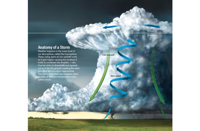
Sometimes these cloudy clashes can cause rain, as the cooling warm air is forced to drop its water.
It’s not just fronts that can make it rain; convection can also drive precipitation.
As warm, moist air rises, it also cools, and its water condenses onto airborne particles such as dust.
These droplets are carried aloft by rising air, growing larger and larger until they become too heavy and fall back to Earth.
When that happens, grab your umbrella.
Once a storm has formed, if there’s nowhere for it to get more moisture from the ground or the air, it will peter out as it lumbers along.
If it finds more warm air and moisture — like a hurricane does as it moves across the ocean — it will grow and grow.
Forecasting Basics
With so many factors involved, it may seem impossible to predict what weather is on the horizon.
But that’s far from the case.
“Weather forecasting is one of only a few fields where we can accurately forecast the evolution of a system.
We cannot do that in economics or sports,” says Falko Judt, a research meteorologist at the National Center for Atmospheric Research in Boulder, Colorado.
Doing so depends on reliable observations.
Scientific weather observations began in the Renaissance, when barometers and thermometers were invented.
European scientists of old, like Galileo, used these instruments to take the types of measurements that would one day explain weather events.
By the late 1800s, rudimentary weather maps had come into common use.
But early forecasts were limited and relied on persistence, or the assumption that a system’s past would dictate its future behavior.
“If a storm system is in Kansas one day and Missouri the next, then by persistence you can say it’ll be in Illinois the next day,” explains Bob Henson, a meteorologist who writes for Weather Underground.
Persistence is an OK way to predict the weather when conditions are constant — when a storm trundles along without breaking up or the local climate changes little day to day, say, in Southern California.
But this simple technique doesn’t account for changing conditions, such as storms that form quickly through convection (typical for thunderstorms) or moving fronts that change the temperature.
Luckily, we have newer, better ways to predict the future.
Today’s weather forecasts aren’t made by people looking at weather maps and yesterday’s highs and lows — they’re made by machines.
Meteorologists use a process called numerical weather prediction to create forecasts by inputting current conditions — which they call the “nowcast” — into computer models.
The more current and accurate information available to these models, the better the forecast will be.
Ground radar, weather balloons, aircraft, satellites, ocean buoys and more can provide three-dimensional observations that a model can use.
This allows meteorologists to simulate what the atmosphere is currently doing and predict what will happen in the next few days or, for some models, hours.
Weather models divide a region, say a single state or even the whole globe, into a set of boxes, or cells.
The size of these cells — the resolution of the model — affects its forecasting accuracy.
Large boxes mean poor resolution, or the inability to tell what’s happening over small areas, but a broad picture of large-scale weather trends over long timelines.
This big-picture forecast is helpful when you want to know how a big storm will move across the U.S.
over the course of a week.
Smaller boxes mean higher resolution, which can forecast smaller storms.
These models are more expensive in terms of computing power, and only run to the one- or two-day mark to tell people whether it might storm in their local area.
Although all models are based on the same physics, each translates those physics into computer code differently, says Judt.
Some models might prioritize certain kinds of data — such as wind speed, temperature and humidity — over others to generate predictions, or simulate physical processes slightly differently than another model.
That’s why two models might spit out slightly different results, even with exactly the same starting observations.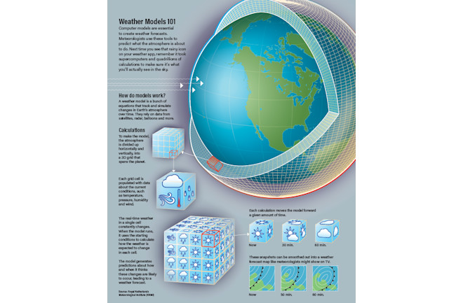
With computers now running the show, what’s left for human forecasters to do?
In terms of day-to-day weather like temperatures, perhaps not much.
“For a lot of the routine weather, the forecast models are so good now that there’s really not that much that the human forecasters are going to add,” says Schumacher, who is also an associate professor in the Department of Atmospheric Science at Colorado State University.
But don’t think humans are unnecessary just yet.
“A forecaster might tweak what the computer tells you if they know their area really well and they know that models struggle with a certain kind of weather situation,” says Henson.
One such situation is precipitation, which is more challenging to forecast than temperature, says Matt Kelsch, a hydro meteorologist at the University Corporation for Atmospheric Research in Boulder.
“Temperature is a continuous field, meaning there’s a temperature everywhere,” he explains.
“But precipitation is a discontinuous field, meaning there’s a lot of places there is none, and then some places that it can be raining or snowing very hard.” And local geography — mountain ranges, coastlines or the Great Lakes — can affect precipitation in ways that models may not handle well.
Particularly for forecasts within 24 to 36 hours, Kelsch says, a meteorologist’s experience with the forecasting area comes into play.
Forecasting high-impact situations such as hurricanes, tornadoes and floods is more challenging and comes with much higher stakes.
“Especially when it comes to extreme weather, human judgment is really important,” Henson says.
The further in the future your picnic is scheduled, the harder it is to predict rain or shine.
But since the 1950s, ever faster computers have been producing increasingly accurate weather forecasts.
“Many of the world’s largest and most powerful supercomputers are devoted to atmospheric research — to forecasting [weather] and to studying climate change,” Henson says.
According to National Oceanic and Atmospheric Administration, today’s five-day forecast is accurate about 90 percent of the time.
The seven-day forecast is correct 80 percent of the time, and a 10-day forecast reflects the weather that actually occurs about 50 percent of the time.
What about major events? Based on National Hurricane Center forecasts since 2010, a hurricane’s eye made landfall, on average, just 47 miles from where a prediction 24 hours earlier said it would.
That’s only about one-sixth of an average hurricane’s total size.
“Twenty-four hours before a hurricane strikes land, we’ve already pretty much nailed down where it will go,” says Judt.
Going out to five days, the error in the forecasts since 2010 is about 220 miles.
These stats are more impressive when you consider how much meteorologists have improved the number of days out to which an accurate forecast can be made.
For instance, today’s five-day hurricane forecast is more reliable than the four-day forecast in the early 2000s, and more reliable than a three-day forecast in the 1990s.
And a 2015 Nature paper revealed that three- to 10-day forecasts have been improving by about a day per decade — meaning a modern six-day forecast is as accurate as a five-day forecast 10 years ago.
As forecasts improve, one question naturally arises: How much better can they get?
Unfortunately, the chaotic nature of our atmosphere seriously limits our ability to model it — and therefore to predict what it will do next.
You’ve probably heard that a butterfly flapping its wings in Hong Kong might cause the weather to change in New York.
The idea of this “butterfly effect” — in which minuscule changes can have huge impacts on the development of a dynamic system — was coined in 1972 by mathematician and meteorologist Edward Lorenz.
In practice, this means that a single weather model run more than once with even the most subtle differences in starting conditions can produce very different predictions.
Since no measurement is perfect — every observation has an associated uncertainty — these small imperfections can cause big changes in what a model predicts.
These changes get bigger and bigger the further ahead you try to predict.
Because of this, the potential predictability limit of weather is about two weeks, says Henson.
“[Lorenz] essentially said there’s just no way you can predict weather features beyond that time because those little butterfly wing flaps and countless other little things will add up to so many big changes, and there’s so much uncertainty beyond that range, that it’s just impossible to say anything,” he says.
Judt, whose work focuses on the theoretical limit of accuracy in weather forecasting, says we’ll never be able to predict thunderstorms more than a couple of hours in advance, regardless of how good observations become.
For hurricanes and winter storms, which are much bigger and therefore easier to spot in advance, the theoretical limit is two to three weeks — “so there’s still a couple of days to be gained, if not a whole week,” he says.
“We could forecast perfectly if we had perfect knowledge of the atmosphere and if we had perfect weather models,” Judt says.
But we will never be able to measure everything about every point in the atmosphere all the time with ultimate precision, and our models will never be flawless.
“So we will never be able to actually achieve perfect forecasts.”
There are more ways to improve forecasts than taking better observations and improving our weather models.
Understanding how people use forecasts and warnings allows meteorologists to provide information in the most useful way.
 (Credit: Roen Kelly/Discover)
Take, for instance, today’s chance of rain in your area.
This could mean slightly different things coming from different meteorologists, but in general, it’s not simply the odds that you, personally, will witness rain that day.
Most forecasters calculate this number by multiplying their confidence that rain will occur by the area in which the rain might happen.
So a 40 percent chance of rain might be a 100 percent chance in 40 percent of your county, or, a 60 percent chance across 70 percent of your county.
In addition, what this number doesn’t tell you is how much it will rain, how hard, when or for how long.
So the next time you see a low chance of rain in your forecast, check the full weather report before you leave the umbrella at home.
“The science has outrun our communications skills and knowledge, to a certain extent.
So a lot of the challenge now is, how do we get people what they need?” says Henson.
That’s because more information isn’t always the best way to communicate.
“If people don’t understand it, then it doesn’t help,” he says.
NOAA is working with social scientists to develop forecasts that are more relevant and better targeted.
This is especially important because of how the internet has changed the way people obtain and share information, Kelsch says.
For instance, when creating the official forecast, meteorologists account for uncertainties by running a model several times.
Each time, the model will give a slightly different result, but most results will be very similar.
This ensemble of predictions is what becomes the official forecast.
But outlying, low-probability results occur in the ensemble, too.
Since these data are accessible to the public, there’s always a risk the data will be shared out of context on social media.
“That’s not a challenge that’s going away,” says Kelsch.
And though forecasts have improved dramatically, meteorologists are still blamed when they are wrong.
“We always need to remember that there never will be perfect forecasts, but we’re still improving them,” Judt says.
Because for all of us, “the most salient weather forecast is the one that was wrong — when you expected something and you were surprised, those are the ones you remember.
You don’t remember all the times that it was just as we expected because that’s not news,” Henson says.
For meteorologists, then, the end goal is to make almost every day’s forecast an utterly forgettable one.
In many countries, a single public weather service is typically the only source available for forecasts, warnings and alerts.
These meteorologists work for public (government) organizations or universities.
By contrast, the United States has strong public, private (commercial) and university-based weather observation and forecasting programs.
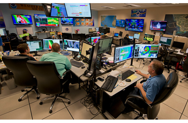
Here, meteorologists monitor Hurricane Irma in September 2017 at the hurricane center in Miami.
(Credit: Andy Newman/Associated Press)
“We also are a large country and a populous country, and one with a great deal of weather variation.
I think all those things have strengthened our interest in weather and our support for weather research and forecasting,” says Weather Underground’s Bob Henson.
In other words, the U.S. is a bit of a weather powerhouse.
Here, most forecasts originate at the National Centers for Environmental Prediction (NCEP).
These centers are part of the National Weather Service (NWS), which itself is a part of the National Oceanic and Atmospheric Administration (NOAA).
The NCEP runs weather models, then disseminates the results — as well as forecasts — to NWS offices, which may customize the forecasts for their region.
For long-term, large area predictions, the most popular U.S. model is the Global Forecast System, or GFS.
On June 12, NOAA announced its first major upgrade for GFS in nearly 40 years.
The upgrade incorporates a new dynamical core, which is the model’s description of how the atmosphere behaves.
The new system, called GFS-FV3, is better at modeling moisture and clouds, allowing meteorologists to forecast storms with greater accuracy than ever before.
Commercial weather providers typically have some weather modeling capabilities of their own.
For example, Weather Underground refines the official forecast to a neighborhood scale by adding information from its network of over a quarter-million personal weather stations.
This gives you accurate weather information for your exact location when you open the service’s app, rather than what the weather is doing across town.
Each company fills a different niche, providing different forecasts that focus on, say, surfing conditions, fire conditions or transportation concerns, based on specific observations and models that refine the broad public-sector data.
These differences are also why you might prefer using one app or service over another.
No comments:
Post a Comment