NASA image by Jeff Schmaltz, LANCE/EOSDIS Rapid Response
From NASA by Adam Voiland
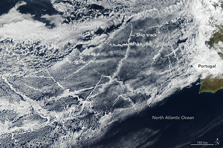
Ships churning through the Atlantic Ocean produced this patchwork of bright, criss-crossing cloud trails off the coast of Portugal and Spain.
The narrow clouds, known as ship tracks, form when water vapor condenses around tiny particles of pollution that ships emit as exhaust or that form from gases in the exhaust.
Ship tracks typically form in areas where low-lying stratus and cumulus clouds are present.
Some of the pollution particles generated by ships (especially sulfates) are soluble in water and serve as the seeds around which cloud droplets form.
Clouds infused with ship exhaust have more and smaller droplets than unpolluted clouds.
As a result, the light hitting the polluted clouds scatters in many directions, making them appear brighter and thicker than unpolluted marine clouds, which are typically seeded by larger, naturally occurring particles such as sea salt.
Several shipping lanes intersect in the waters off the coast of Portugal.
Visualizations of ship traffic show large numbers of ships entering and exiting the Mediterranean Sea in this region.
Many of them hug the coast of the Iberian Peninsula as they travel toward ports in northern Europe. In this case, the large volume of ships along the coast appear to have brightened the clouds so much that it is difficult to distinguish individual ship tracks.
The more visible tracks are several hundred kilometers offshore, and many of these appear to be created by ships heading out of the Mediterranean Sea toward North America.
Others are probably the result of ships from South America and Africa charting courses toward northern Europe.
The Moderate Resolution Imaging Spectroradiometer (MODIS) aboard the Aqua satellite captured this natural-color image on January 16, 2018. Some of the criss-crossing clouds stretch hundreds of kilometers from end to end.
The narrow ends of the clouds are youngest, while the broader, wavier ends are older.
Age is not the only factor that affects the appearance of ship tracks. NASA scientists have identified specific atmospheric conditions that affect their brightness, or albedo.
One key factor is the structure of clouds already in the area. Ship tracks clouds that form near open-cell clouds—many of which are present in this image—tend to be brighter than those that form near close-celled clouds.
(Open-cell clouds look like empty compartments, whereas closed-cell clouds look like compartments stuffed with clouds.)
The high reflectivity of ship track clouds means they shade Earth’s surface from incoming sunlight, which produces a local cooling effect.
However, determining whether ship tracks have a global cooling effect is challenging because the way particles affect clouds remains one of the least understood and most uncertain aspects of climate science.
Links :
- Chen, Y.-C. et al. (2015, April 3) Aerosol-cloud interactions in ship tracks using Terra MODIS/MISR
- NASA’s Earth Observing System (2007) The Dynamic Atmosphere - Ship Tracks
- NASA Earth Observatory (2012, March 8) Ship Tracks off the California Coast
- NASA Earth Observatory (2012, March 8) Ship Tracks off the Kamchatka Peninsula
- Toll, V. et al. (2017, December 28) Volcano and Ship Tracks Indicate Excessive Aerosol-Induced Cloud Water Increases in a Climate Model
- GeoGarage blog : Ship tracks off North America / Ship tracks reveal pollution's effects on clouds / Image of the week : satellite's view of ship pollution / Warns of the effects of shipping emission policy on ...

No comments:
Post a Comment