
Team Vestas Wind grounding on the Cargados Shoals
From NYTimes by Chris Museler
Even though Chris Nicholson entered the Volvo Ocean Race
only two months before the start last October, his four races’ worth of
experience made him a favorite in the around-the-world event.
He
believed he could win.
Team Vestas Wind is back in the race.
This is the movie that has been shown exclusively at our cinema in the Race Villages around the world, the full story from when Team Vestas Wind were shipwrecked in the middle of the Indian Ocean.
Nicholson,
a champion sailor from Australia, had to recalibrate his aspirations
after his Team Vestas Wind VOR 65 race boat crashed into a wave-swept
reef in the Indian Ocean on the second leg of the race.
The crash tore
off the back of the boat.
The
team rebuilt the boat in four months and rejoined the fleet last
weekend in Lisbon for the final two legs of the 39,000-nautical-mile
race.

Nicholson’s second-place finish in Lorient, France, this week
behind the all-women crew of Team SCA confirmed his high hopes for Team
Vestas Wind’s return, although he said last week that two podium
finishes would be bittersweet.
“Everyone on our team has a lot of pride,” Nicholson said the day before
the start of this week’s race from Lisbon to Lorient.
“If we do show
our potential, it will probably hurt even more, knowing we could have
done well and had a chance to win the event.”


Team Vestas Wind boat recovery
Team
Abu Dhabi finished third in Lorient behind Team Vestas Wind, extending
its overall lead in the race.
Lessons learned from the Vestas team’s
accident have been put into effect in the race, and navigational
improvements will probably make their way to the average boater in the
future.
On
Nov. 29, the boat was reaching nearly 20 miles per hour when it drove
into the Cargados Carajos Shoals, an atoll 200 miles from Mauritius.
The
crew of nine was unhurt and left stranded on the reef.
The stranded
members were assisted by Team Alvimedica and were rescued after a
harrowing night in breaking waves and razor-sharp coral.


It
took a month for Vestas, the sponsor, to commit to rejoining the race.
The decision was made to painstakingly remove the mangled boat from the
reef and rebuild it in half the original build time at Persico Marine in
Genoa, Italy.
“We
knew that our story could not end on that reef,” Morten Kamp Jorgensen,
the team’s communications director, said in an interview this week.
“We
reshuffled our budgets and organization. This was a race to ensure that
Vestas will be remembered as a team that overcame challenges.”

Unbreakable : Team Vestas Wind navigator Wouter Verbraak has done a lot of
soul-searching since the Indian Ocean grounding that changed his life,
and he’s spent most of that time writing a book about it. Cleverly
scheduled for release just before the end of the VOR, the book promises
to “inspire, provoke thought and entertain.”
The book (pre-order here) details the disaster, the lessons learned with the
benefit of hindsight; and the overlap with a commercial setting where
the level of critical thinking mirrors that of an ocean racing navigator
– the major decisions made and the subsequent decisions to ensure they stay the course.

The individual
skill set, the importance of psychology and a strong mental edge in a
team setting are fundamental to Wouter’s personal development; the
ascent to the summit of ocean racing.
An equal among the world’s most
sought after circumnavigators and strategists.
- courtesy of Sail Anarchy -
An
inquiry into the accident revealed that the navigator, Wouter Verbraak,
had not zoomed in enough on the boat’s navigation system to see the
exposed reef.
Investigators found that “at different times the navigator
zoomed in on the electronic chart and came to the same incorrect
conclusion.”


World Map Coverage in C-Map of Cargados Carajos Shoals – what was presented on Adrena
and Expedition software without the detailed C-Map dongle –
the presentation the navigator had on his personal
computer

Southern tip of Cargados Carajos Shoals – showing the chart by chart display on CMap/Expedition
at Level C/0 Scale1: 328,066 and displaying a small segment of the larger scale chart
Since the inquiry, small changes have been made to the race’s rules.
Officials have said there will be more.
“We
became more aware of the zoom levels, for sure,” the race’s director,
Jack Lloyd, said in a phone interview from Lorient this week.


The B&G Zeus 7 MFD chartplotter default world-coverage map does include a depiction of the Cargados
Carajos Shoals.
When the navigator awoke after the grounding he went to the nav station and could
clearly see the reef on the MFD and the boat next to it.
“We have
recommended strongly that teams install different charting systems with
more information. Each chart has what the manufacturer wants, but there
are differences.”
Lloyd
said that all navigators chose their own navigation software but that
all the boats were provided with C-Map digital charts.
According to the
inquiry, the Cargados Carajos Shoals were not seen at the most
zoomed-out display level.
The race recommends that digital maps show
reefs and islands at all levels of display, and Lloyd said the race was
working with C-Map on such changes, which may eventually affect the
average sailor.
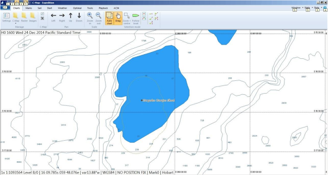
 Expedition/C-Map presentation of Cargados Carajos Shoals at Level B/0 (1:1.1million)

 Expedition/C-Map presentation of Cargados Carajos Shoals at Level B/0 (1:1.1million)
displaying the ‘Chart Bounds’ of the reef and dangers and the ‘Cautionary Areas’ marking the Territorial Sea

Part of the large scale chart available on Expedition/C-Map –
but was not
available on the weather routing
laptop with the Adrena software,
so the dangers of the Cargados Carajos Shoals
would not have been visible
on this second navigation system.
“We are also reassessing the level of competency on each boat,” said Lloyd, who has been the race director since 2008.
The
accident highlighted the heavy reliance on electronic navigation, he
said, although the race provides paper charts for all the seas the boats
will be racing.
“But
they’re stopping printing of paper charts, and some are quite old,”
Lloyd said.
“Some say they are not accurate, but digital charts have
problems, too.”


A comparison between the detail shown on Expedition/C-Map Level A/0 1:3.3 million
and UKHO
Chart 4702 Chagos to Madagascar 1: 3.5 million
Paper charts and the race-provided sextant are age-old navigation tools that are good backups, Lloyd said — if the sailors know how to use them.
“It’s
funny; it’s a new way forward,” he said.
“We have to make sure the
skills are there. There’s something useful about being able to spread
out a whole chart of the Pacific and see every island.”


Nicholson is no stranger to high-seas calamity.

The ENC data quality feature.
An ECDIS screen shot of French ENC FR274880
Zoomed in on
Cargados Carajos Shoals – with ZOC switched on displaying 4 stars ZOC B
at the reef and 2 stars ZOC D in
surrounding ocean
GeoGarage animation
with official ENCs (courtesy of 7SCs)
with official ENCs (courtesy of 7SCs)
Nicholson is no stranger to high-seas calamity.
In the 2005-6 race, he tried to
connect power to underwater bilge pumps before abandoning the sinking
Spanish entry Movistar in the North Atlantic.
Nicholson
said there were obvious technological changes to be made to help
prevent the human error that had led to the grounding of Team Vestas
Wind.
“There
has to also be an impact on the boating community purely from the story
of the accident,” he said.
“The sheer example of it will help prevent
these accidents.”
Nicholson said he still felt pressure in the race, even though a top-three finish was out of reach.
“But
that goes with the territory,” he said.
“I don’t think we can have more
pressure during the race than we had getting the boat here.”
Links :
Links :
SailMagazine : Vestas Wind and the Cargados Carajos Shoal
ReplyDeleteYacht : Ran aground on a reef and almost completely destroyed
ReplyDelete