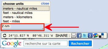
 for the scale bar
clicking to change the scale bar units and switch between :
meters - nautical miles switch (scale : 750 m then next lower scale : 2 nm)
feet - nautical miles switch (scale : 5000 feet then next lower scale : 2 nm)
meters - kilometers switch (scale : 750 m then next lower scale : 2 km)
feet - miles switch (scale : 5000 feet then next lower scale : 2 miles)
Note : this setup doesn't affect the display of the global distance for a route
-always displayed in meters if D is less of 1852 meters and in nautical miles (nm) if D is greater than 1852 m-
 for the Latitude / Longitude display of the cursor position (WGS84)
clicking to select the format on the dedicated icon and switch between :
Degrees & Decimal Minutes : DD°DD.DDD' (default setting for marine locations)
Degrees, Minutes, Seconds : DD°MM'SS.SS''
Decimal degrees : DD.DDDDDDD° (submeter precision, around 0.3 meter at higher Google Maps scale)
No comments:
Post a Comment