From Federica Shipping Brief
China’s Arctic strategy is entering a new phase — one defined less by symbolic research presence and more by hard maritime capability.
In December, the state-run 708 Research Institute unveiled a conceptual design for a nuclear-powered, bull-nosed icebreaker capable of breaking through floes up to 2.5 metres thick.
Officially described as a “multirole” cargo and polar tourism vessel, the ship is intended to serve as a prototype for China’s emerging polar fleet.
While framed in commercial and research terms, the development is best understood within the broader context of shipping security, trade resilience and long-term commodity access.

While framed in commercial and research terms, the development is best understood within the broader context of shipping security, trade resilience and long-term commodity access.
A new conceptual design of a nuclear-powered multirole icebreaker developed by China State Shipbuilding Corp.
[Photo provided to China Daily]
The industrial base: dual-use capacity
The strategic signal lies not only in the ship itself, but in who is building it.
The yard responsible for China’s first indigenous icebreaker also delivered the aircraft carrier Fujian, now operated by the People’s Liberation Army Navy.
The strategic signal lies not only in the ship itself, but in who is building it.
The yard responsible for China’s first indigenous icebreaker also delivered the aircraft carrier Fujian, now operated by the People’s Liberation Army Navy.
That yard falls under China State Shipbuilding Corporation (CSSC), one of the world’s largest shipbuilding conglomerates.
For maritime observers, this matters.
Icebreakers are not simply commercial assets.
For maritime observers, this matters.
Icebreakers are not simply commercial assets.
They are sovereignty tools— enabling year-round access, hydrographic mapping, escort capability and sustained presence in contested or infrastructure-poor waters.
A nuclear-powered platform, in particular, signals endurance and strategic commitment rather than seasonal experimentation.
The trade logic: distance, diversification, and redundancy
Beijing’s 2018 Arctic policy introduced the concept of a “Polar Silk Road.”
A nuclear-powered platform, in particular, signals endurance and strategic commitment rather than seasonal experimentation.
The trade logic: distance, diversification, and redundancy
Beijing’s 2018 Arctic policy introduced the concept of a “Polar Silk Road.”
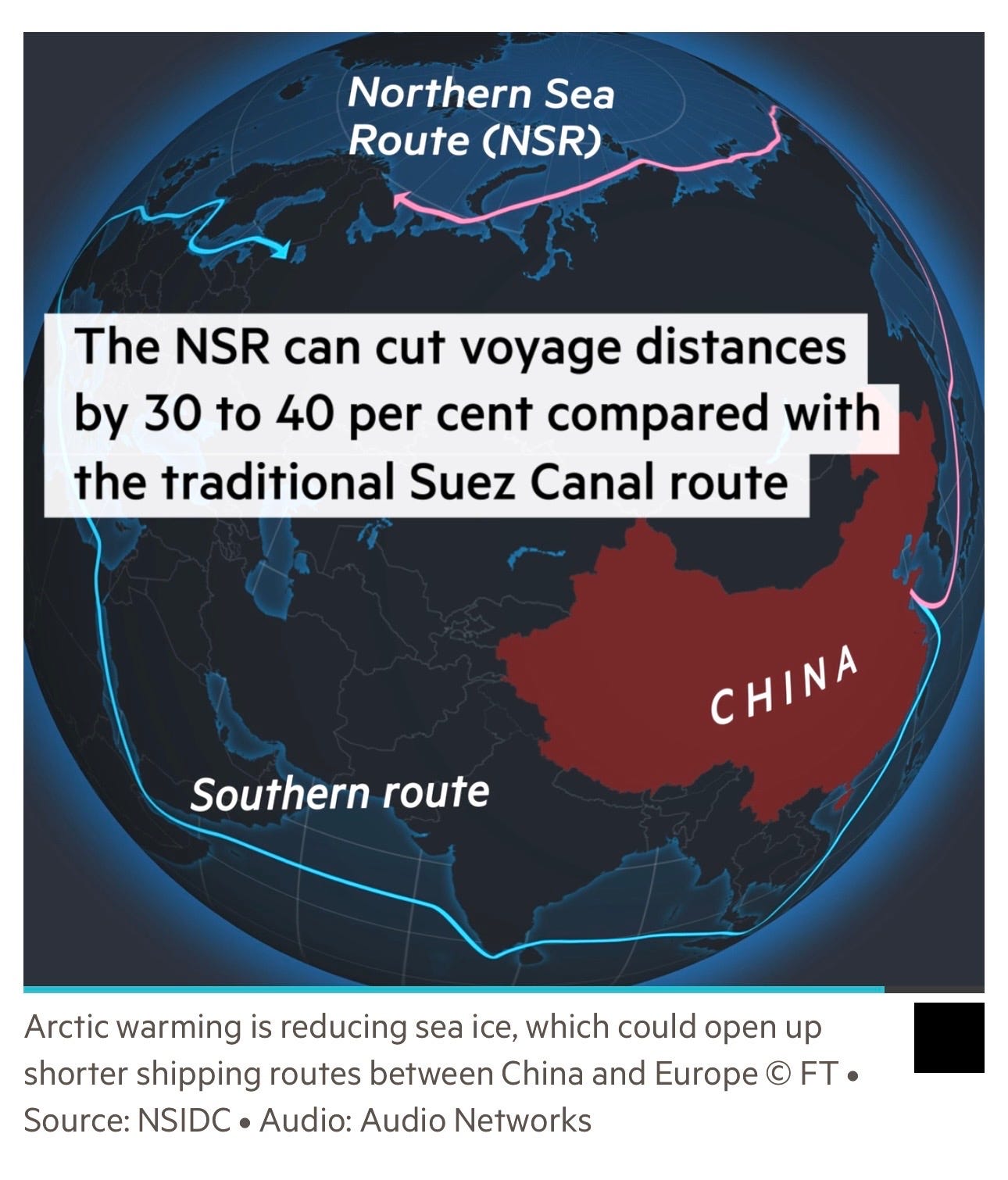
The core argument is geographic: Arctic routes, particularly via Russia’s Northern Sea Route (NSR), can cut voyage distances between northern China and northern Europe by 30–40% compared to the Suez Canal corridor.
In September, the container vessel Istanbul Bridge sailed from Ningbo to Felixstowe via the NSR — described in Chinese state media as the opening of a “China-Europe Arctic Express.”
From a freight economics perspective, however, several realities remain:
In September, the container vessel Istanbul Bridge sailed from Ningbo to Felixstowe via the NSR — described in Chinese state media as the opening of a “China-Europe Arctic Express.”
From a freight economics perspective, however, several realities remain:
- Seasonality limits predictable scheduling.
- Ice-class premiums and insurance costs erode distance savings.
- Search-and-rescue and port infrastructure remain underdeveloped.
- Sanctions exposure and geopolitical risk complicate Western-facing trade.
For southern Chinese exporters, Suez often remains operationally faster despite longer nautical miles.
In other words, the Arctic is not yet a Suez replacement.
In other words, the Arctic is not yet a Suez replacement.
It is a strategic hedge — a redundancy option in a fragmented global trade system increasingly shaped by chokepoint risk.
Commodities: energy, minerals and Arctic logistics
Where the Arctic becomes more structurally significant is in commodities.
China has expanded investments in Russia’s north, including coal developments near Murmansk and port infrastructure in Arkhangelsk.
State shipping giant COSCO Shipping is widely expected to anchor logistics activity through Arctic gateways.
The Arctic offers three strategic commodity levers:
The Arctic offers three strategic commodity levers:
- Hydrocarbons — LNG and offshore oil potential.
- Critical minerals and rare earths — increasingly central to energy transition supply chains.
- Alternative export corridors for Russian volumes, particularly as sanctions reshape global flows.
Over time, that shifts the economics of upstream investment and midstream transport.
Governance and geopolitical friction
China describes itself as a “near-Arctic state,” a classification rejected by several Arctic governments. The eight Arctic states have historically limited formal governance roles to themselves.
Meanwhile, Washington has earmarked $9bn for icebreakers and polar infrastructure to maintain US leadership in the region.
NATO-controlled territories — including Canada and Greenland — sit astride key North Atlantic access points.
Yet analysts note important nuance:
For maritime and commodity participants, the Arctic is no longer a theoretical trade lane. It is an emerging strategic variable.
Three implications stand out:
Yet analysts note important nuance:
- Chinese naval patrols with Russia have increased near Alaska.
- There has not yet been a confirmed Chinese military vessel operating in the central Arctic Ocean.
- The Northern Sea Route’s narrow passages and short seasons limit military utility in a conflict scenario.
For maritime and commodity participants, the Arctic is no longer a theoretical trade lane. It is an emerging strategic variable.
Three implications stand out:
- Route optionality will become a core element of supply-chain resilience.
- China–Russia energy integration in the Arctic will deepen, particularly around LNG and minerals.
- Icebreaking capacity will increasingly define access, influence and commercial advantage in polar waters.
But with nuclear-powered icebreakers, port investments and state-backed shipping, Beijing is positioning for a long-term structural presence in northern trade routes.
For markets, the key question is not whether the Arctic will matter — but when its economics begin to align with its geopolitics.
For markets, the key question is not whether the Arctic will matter — but when its economics begin to align with its geopolitics.
Links :
- China Daily : Conceptual design of nuclear-powered icebreaker unveiled


 Doba completing his second trans-Atlantic crossing.
 The Olo, Doba’s 2010 kayak.
 Doba during his second Atlantic crossing. Photo: Nicola Muirhead
  Doba, interviewed at a trade show, 2016.


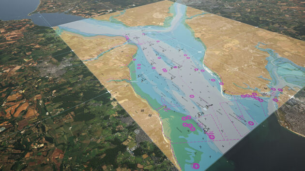


 Satellite imagery of the vessels NORA, HEDY, and PING SHUN at Kharg Island on March 7, 07:31 UTC.
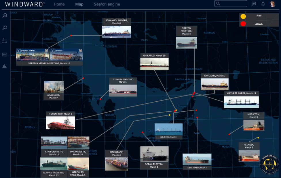 Map of vessel attacks since the start of the Iran War.
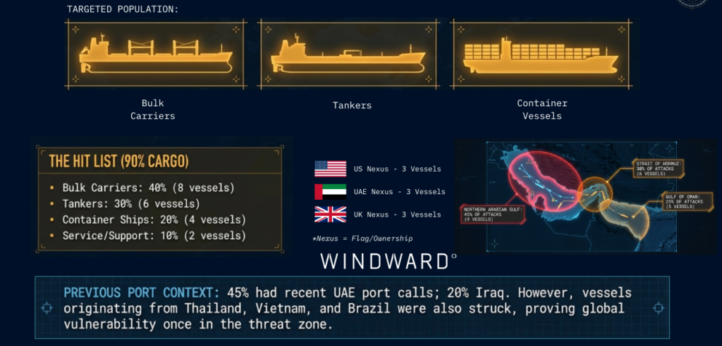


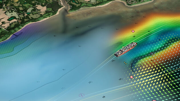
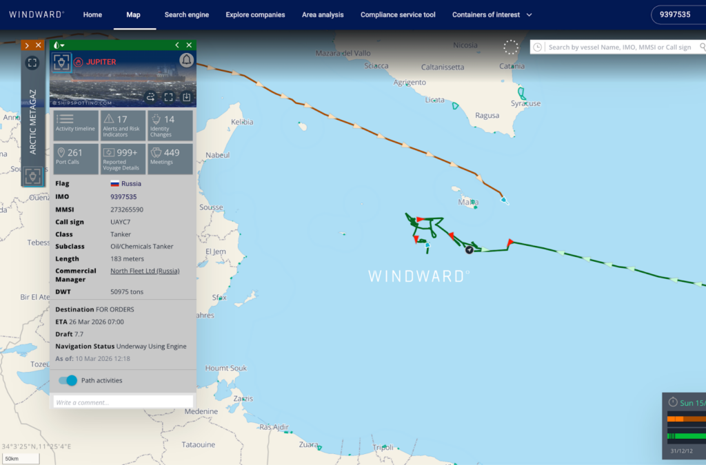 Russian tanker approaching the Arctic Metagaz platform, which has been loitering since March 9.


