Our oceans are changing at an unprecedented rate.
Discover how Saildrone is taking action by building a global fleet of 1,000 wind-powered, emission-free ocean drones to monitor our oceans in real time and working with the science community to improve our collective understanding on how these changes impact people around the world.
From Popular Mechanics by Stav Dimitropoulos
Meet the wind- and solar-powered ocean drones boldly going where humans rarely venture—including the harsh, unforgiving Antarctic.

On January 19, 2019, an unmanned surface vehicle going by the name SD 1020 left Bluff, New Zealand, heavily tasked.
SD 1020 had to cover 22,000 kilometers (11,879 nautical miles) around the Antarctic (Southern) Ocean, where colossal waves occasionally soar to nearly 24 meters, gusting winds exceed 65 knots, and titanium icebergs emerge out of nowhere, as the neophyte ocean envelops Antarctica like the iciest blanket ever—the Earth’s coldest, most remote, and most hostile water mass.
The SD 1020 showed great resolve.
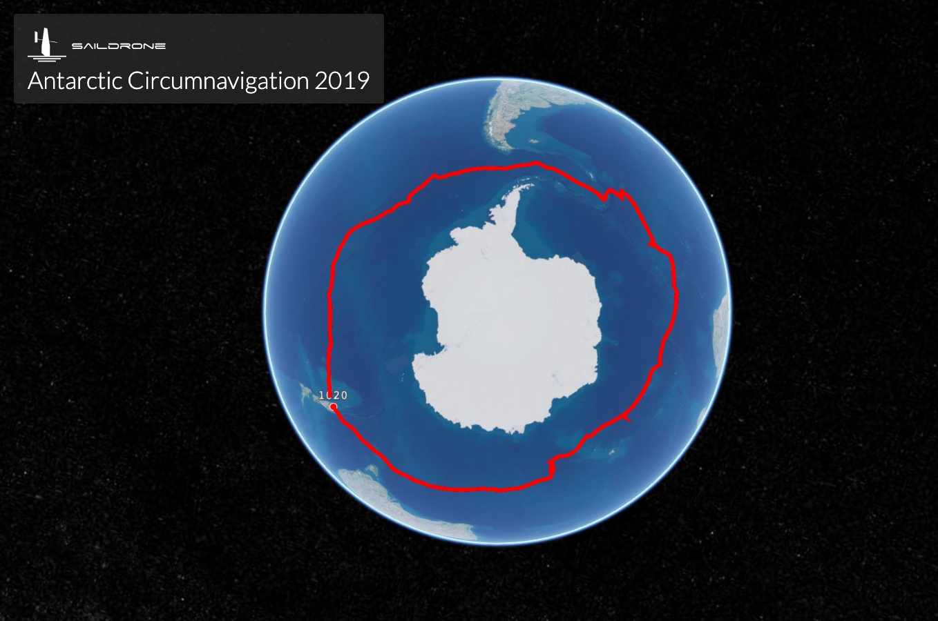
On August 3, 2019, it returned to Bluff safe and became the first vessel ever to have completed an autonomous circumnavigation of the Antarctic.
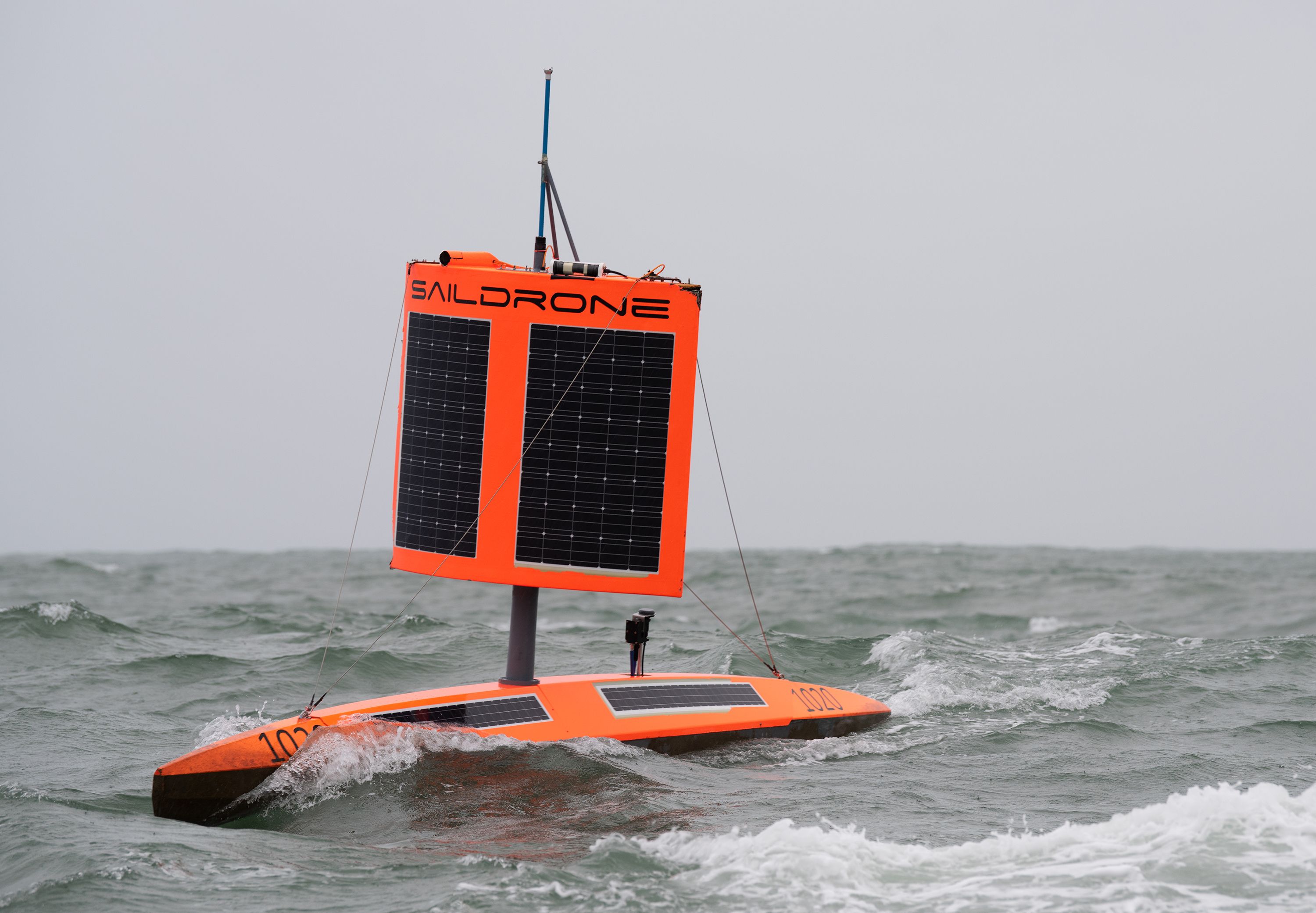
SD 1020 approaches Point Bluff, New Zealand, in stormy conditions after finishing the First Saildrone Antarctic Circumnavigation, sailing 22,000 kilometers around the Antarctic Ocean in 196 days.
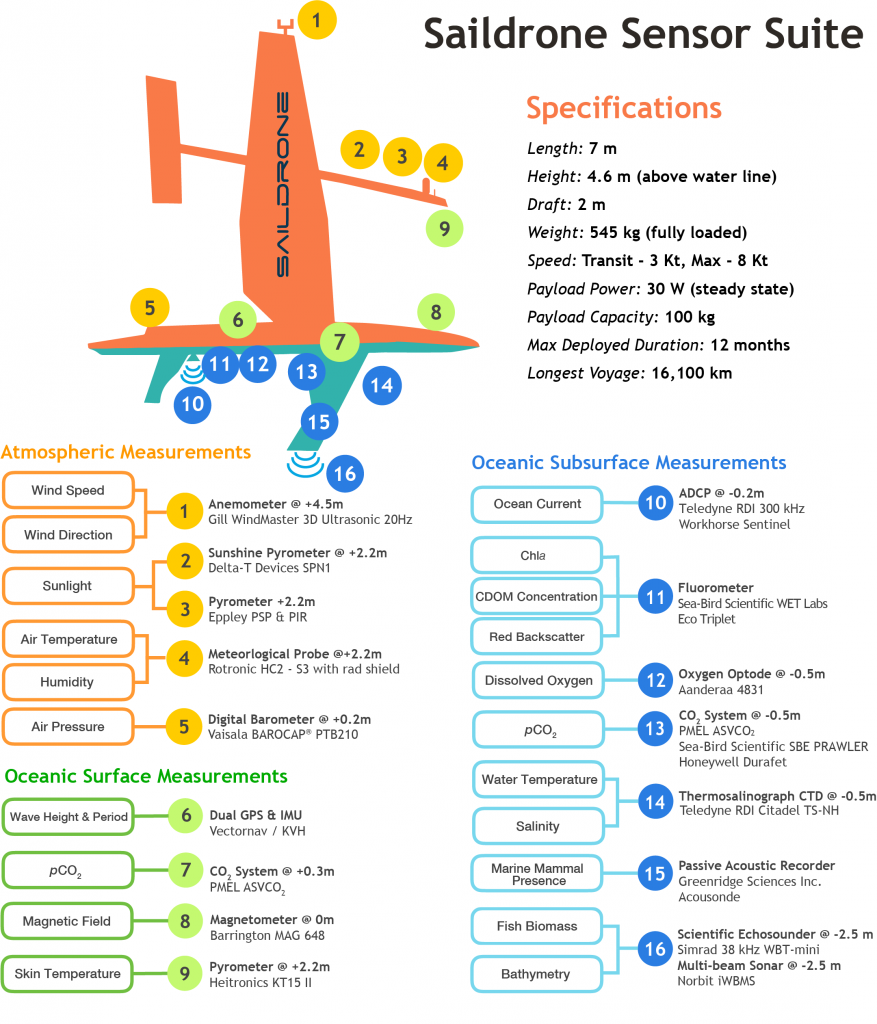
SD 1020 is a member of the wider family of saildrones, wind- and solar-powered ocean drones that are able to sail 100 kilometers per day on average, and which consist of a narrow seven-meter-long hull, a five-meter-tall wing, and a keel with a 2.5-meter draft.
These saildrones can be deployed and recovered from any seaside dock and can fit into a shipping container allowing transit to any launch site.
When they’re deployed from a dock, they can sail to the area of study, and come back once the mission is complete.
“Saildrones are autonomous,” says Richard Jenkins, engineer, founder, and CEO of Saildrone, the company that designs, produces, and manages these USVs.
A human gives them a route to sail and waypoints, and the vehicles get from one waypoint to the next autonomously by themselves.
And they do so without putting to risk the sea or any marine life that crosses their path.
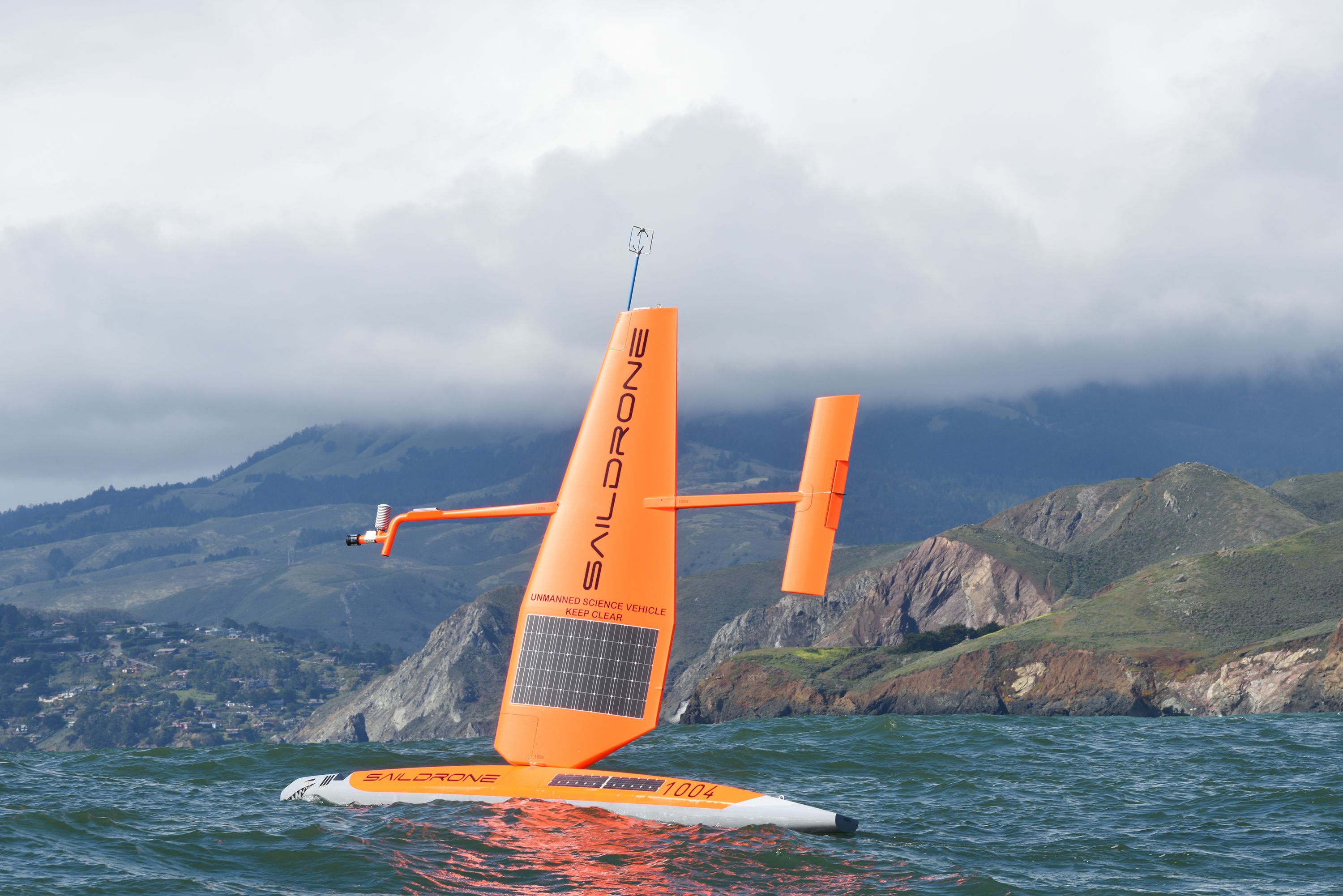
Generation 4 saildrone deployed from San Francisco on the 2018 White Shark Cafe mission.
The technology enabling this autonomy is wholesome: Each USV carries an automatic identification system, navigation lights, a radar reflector, high visibility wing colors, four onboard cameras, acoustic Doppler current profilers (sonar systems to measure water current velocities), passive acoustic recorders for marine mammal studies, and an array of 20 sensors, different for each saildrone (sensors are recruited in alignment with the tasks the human operator wants to complete).
These machines don’t fly, but that doesn’t make them any less fascinating.
Currently, there are about 30 of these autonomous SailDrones deployed around the world.
These vessels are jam-packed with sensors and analyze parts of the oceans where normally very few people venture.
The SailDrone company aims to have about 1,000 of these sailing drones navigating the world in a few years.
Linked to onboard computers and transmitting their data through satellite communications to the Saildrone mission control center in Alameda, California, these sensors can measure anything, whether it be air, sea, and bulk water temperature, irradiance, barometric pressure, wind speed and direction, wave height and period, salinity and acidity levels, biomass and the list goes on.
When SD 1020 was launched from Bluff, it was “ordered” to accomplish a suite of science objectives.
Most of them were about investigating the abundance of krill, the direct and indirect relationships between marine predators and prey, and the oceanic carbon dioxide uptake and general acidification—targets developed in collaboration with prominent research agencies of the U.S., Europe, and Australia.
But SD 1020 didn’t leave the shores of New Zealand alone.
On that same January day, SD 1022 and SD 1023, two more saildrones, were launched alongside SD 1020, but were damaged en route and had to return to Bluff soon after.
(The two drones were relaunched last May and are currently in the Southern Atlantic Ocean, collecting data on krill.)
What made SD 1020 successful was its wing.
SD 1022 and SD 1023 had a tall and slender wing, unable to withstand winds over 60 knots and the subsequent massive waves; au contraire, the triumphant USV had a robust, newly designed “square rig” able to withstand the huge forces of being rolled and submerged by 15-meter waves.
It was a result of 10 years of research that interestingly span from Jenkins’s previous successful attempt to break the land speed record for a wind-powered vehicle.
“The Southern Ocean is one of the most unexamined areas of our planet,” Jenkins says.
“The survival of the saildrone at sea for [so] long is an evolution of very solid engineering,” Jenkins says.
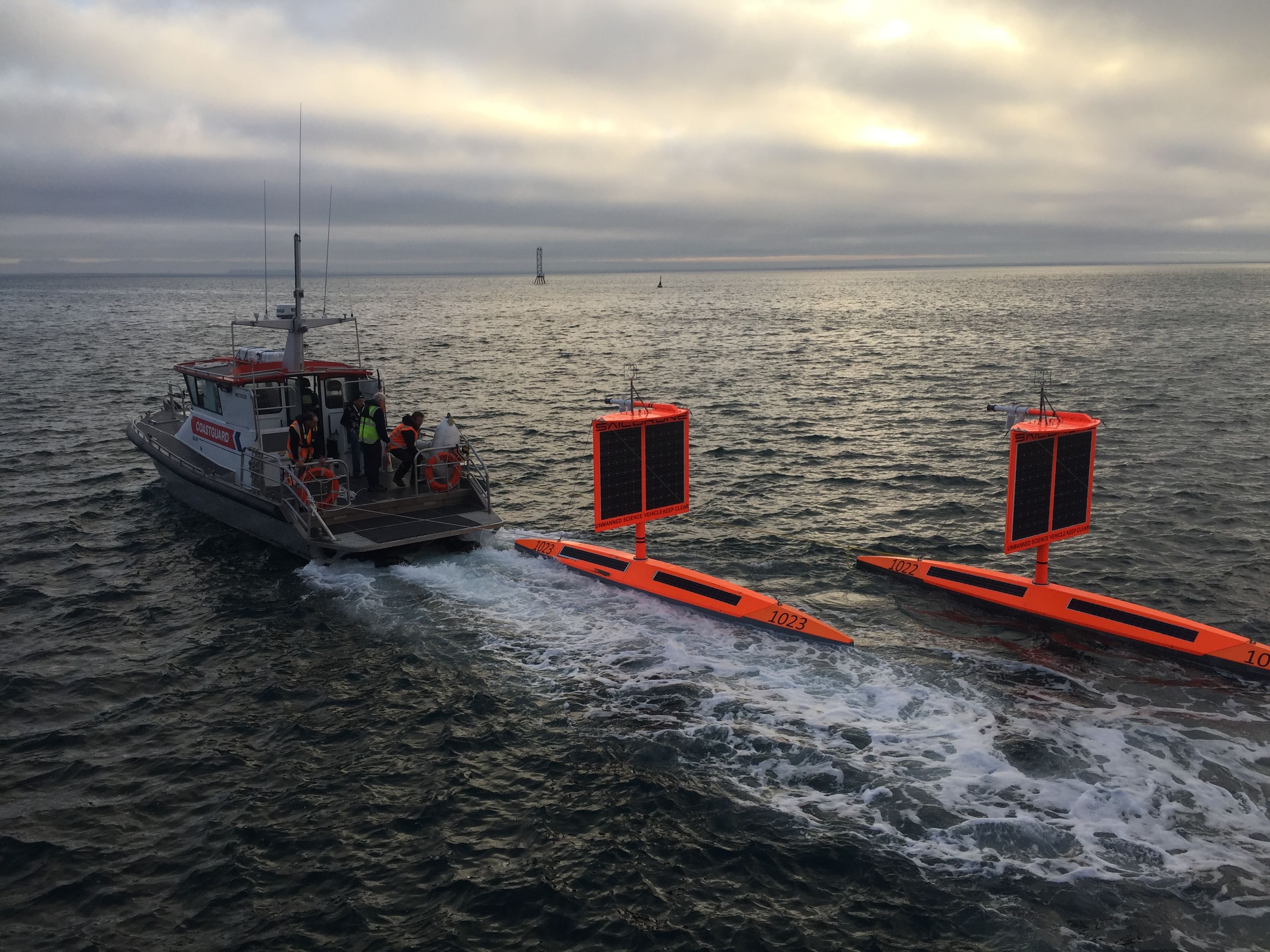
SD 1022 and SD 1023 being redeployed to the Southern Ocean after receiving new "square wings."
Though scientists have yet to wrap up their surveys, Jenkins is confident that the data saildrone SD 1020 brought to shore after circumnavigating the world’s youngest ocean for 196 days will have a tremendous impact on our understanding of the environment, weather, and climate, and will aid the sectors of shipping, fishing and oil and gas exploration.
“We can’t make any sweeping claims before scientists digest the data, but it’s safe to say that we already have important new data, particularly with reference to the rates of carbon uptake in the Southern Ocean,” Jenkins says.
Previous scientific knowledge on the Southern Ocean based primarily on observations made from ships that avoided extreme winter weather conditions in the region assumed that the Antarctic was a huge carbon sink.
But in the face of recent findings, scientists might want to reconsider.
“Work done through the Southern Ocean Carbon and Climate Observations and Modeling project [a multi-institutional program aimed at unraveling the mysteries of the Southern Ocean and determining its impact on the climate] involved deploying pH sensors on autonomous floats in the ocean, a hose developed by Team Durafet, one of the winning Teams in the Wendy Schmidt Ocean Health XPRIZE,” says Jyotika Virmani, physical oceanographer, atmospheric scientist, and executive director of planet and environment at XPRIZE.
“Data showed that the Southern Ocean may not sponge up as much carbon as hitherto thought, however, there was some uncertainty in this data,” Virmani continues.
Obviously, she finds the Saildrone mission a great achievement: “The strong winds and giant waves, and generally extremely harsh conditions of the Antarctic Ocean in the winter make it extremely difficult to accurately sample with manned vessels.
The recent amazing Saildrone mission has shown that advancing autonomous and unmanned technologies can really enhance the understanding of our ocean.”
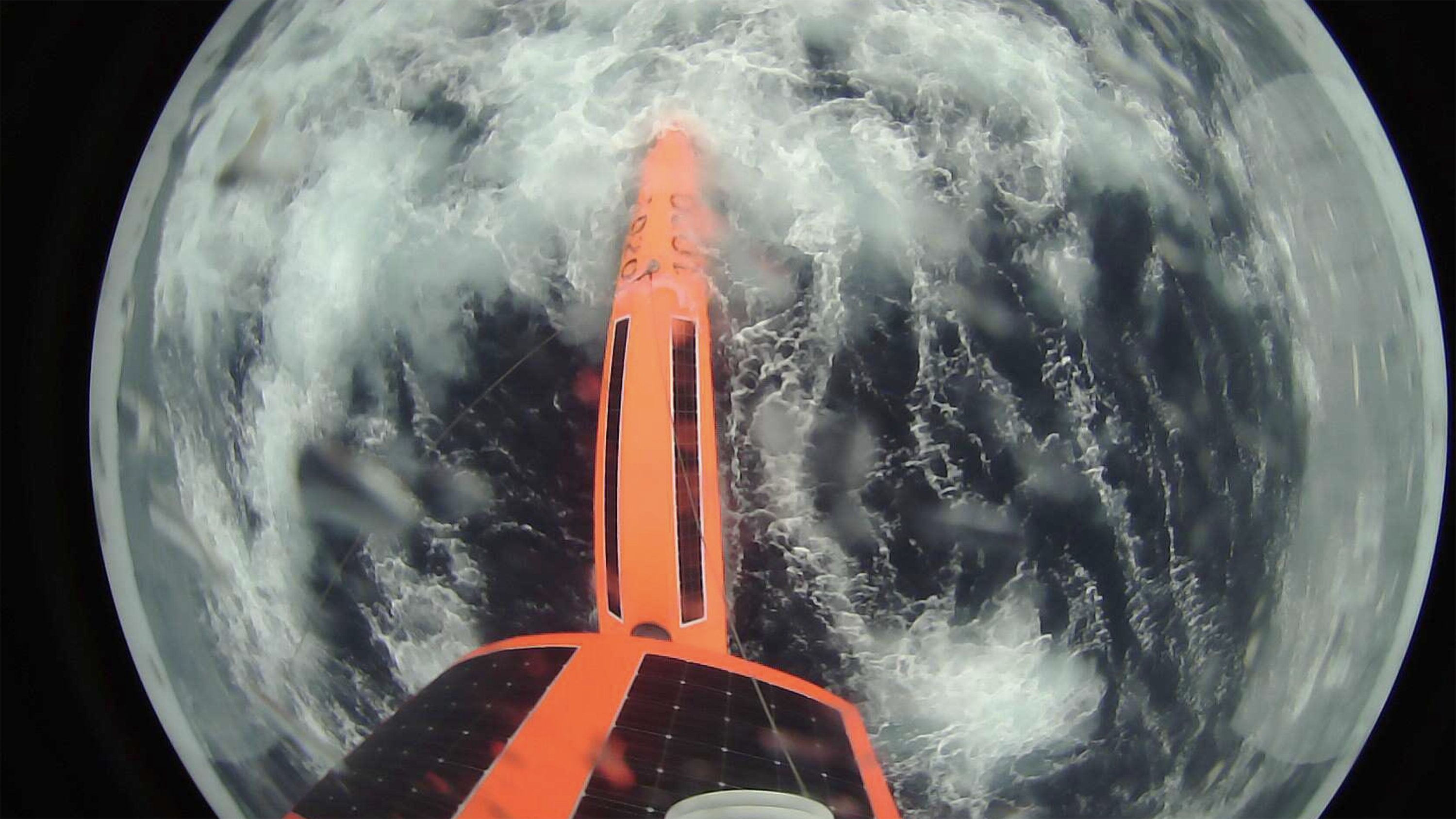
Photo taken from SD 1020’s onboard camera during the 2019 Antarctic Circumnavigation.
Petros Ioannou, professor of electrical engineering systems at the University of Southern California, is also positive that such big strides in ocean exploration are a natural expression of where the technology is headed.
“It’s great to have all these unmanned vehicles,” Ioannou says.
“We are talking about a very hostile environment where it would be risky for humans to be on board.”
So these drones become very potent.
They can discover things previously impossible to discover.
That said, Ioannou is quick to sound a more skeptical note about the safety of the USVs.
“What happens if pirates interfere with the signals coming from the commander control centers and direct the drone elsewhere?” he asks.
“What if you lose contact with the vehicle? How does it recover? What kind of protocols will it follow? How about its failure modes? Can you sink it for example? How do you eliminate the risk of causing epic accidents?” Ioannou says.
Asked about whether saildrones have failure modes, Jenkins says there’s no need for a self-destruct capability on the drones because their data is encrypted, and there’s no scrap value in the vehicle, so the targets for capture in the same way that some USVs, mostly military drones, are.
Ioannou also appears unsure of who is going to benefit from such technologies.
“Let’s say you map the ocean, like we map the space.
Who is going to pay for it? Who would benefit from the knowledge of the deep ocean? We know there are minerals in the ocean floor.
Probably oil mining companies?” he says.
(The Antarctic Ocean is believed to host huge deposits of oil and gas fields on continental margin and valuable minerals like gold).
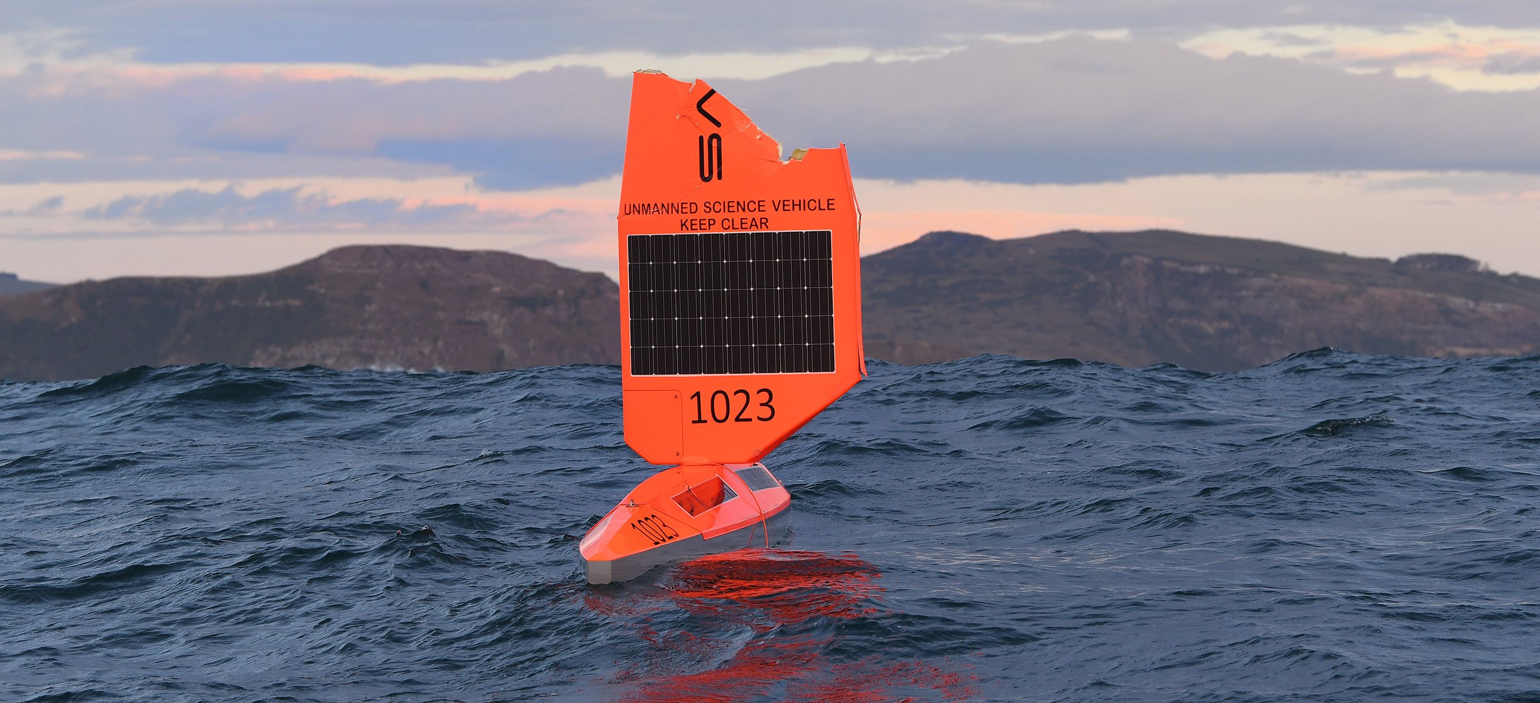
SD 1023 returning to New Zealand for repairs after damage to the wing during a storm in the Antarctic Ocean.
photo : Stephen Jaquiery
Meanwhile, last August, another saildrone family member, SD 1021, completed the fastest unmanned Atlantic crossing.
SD 1021 was launched from Bermuda in the North Atlantic Ocean on May 25, with the mission to sail toward the Solent, the strait that separates the Isle of Wight from the mainland of England, and cover 3,000 nautical miles (5,550 km) in 75 days in the process.

SD 1021’s mission track from Newport, RI, to the Gulf Stream (pink), Bermuda to the UK (green), and back across the North Atlantic to Newport, RI (red).
see Saildrone news
It was one more record-setting race for Saildrone, which, according to its website, collects the data of all its missions for fish stock assessments, marine mammal tracking, bathymetric mapping, monitoring changes to the ocean ecosystem, and improved weather forecasting.
Only at the time of speaking, the company deploys 30 drones around the world, with aims to snowball the size of the fleet.
“We are making 100 drones this year and intend to make 200 next year,” says Jenkins.
“Next year again, we want to have 10 to 20 vehicles permanently circumnavigating the Southern Ocean.”

An estimated 1,000 drones roaming the planet is the Saildrone’s CEO ultimate endgame; he wants to fill the Earth with saildrones.
“We have collected data from where no data has ever been collected before and proven we are capable of navigating anywhere in the world, throughout the entire year,” Jenkins says.
“This opens the door to a whole new chapter in understanding weather and climate.”
Links :
- Maritime Executive : Saildrone Makes Another Record Voyage
- KomoNews : UW studies tiny drone-powered sailboats as potential breakthrough in weather forecasts
- Phys : Saildrone is first to circumnavigate Antarctica, in search for ...
- GeoGarage blog : Saildrone launched with seafloor mapping ...
No comments:
Post a Comment