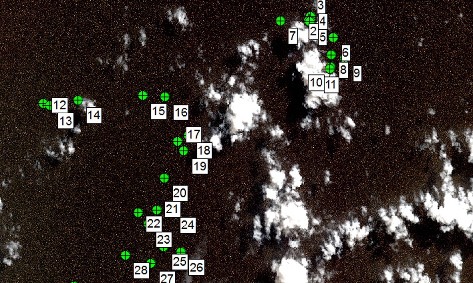
Reports prepared by Geoscience Australia and the CSIRO analyse French satellite imagery taken two weeks after the disappearance of MH370.
Photograph: Byrne Guy/Geoscience Australia
From The Guardian by Oliver Holmes
Drift analysis of debris reveals new coordinates for potential impact location
Australia has released satellite images it says show 12 “probably man-made” objects floating in the sea near the suspected crash site of Malaysia Airlines flight MH370.
Taken two weeks after MH370 disappeared on 8 March 2014, the photos were analysed by the Australian Transport Safety Bureau (ATSB).
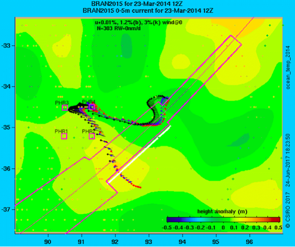
Its researchers used drift modelling of the debris to suggest a new potential location for the crash site — a 5,000 sq km (1930 sq miles) area just north of the former search zone.
Drift modelling from the CSIRO report showing simulated trajectories of debris items over time from a single point of origin: at 35.6 degrees south and 92.8 degrees east.
Australia is on the right of the picture.
Photo: ATSB
Two Australian government agencies, Geoscience Australia and the Commonwealth Scientific and Industrial Research Organisation (CSIRO), analysed the images, which were taken by a French military satellite but not released to the public.
The report said the detected objects appeared to form clusters, rather than being randomly scattered across the area.
The findings seemed to bolster the ATSB’s conclusion last November that the plane most likely crashed north of waters it spent more than two-and-a-half years searching.
The CSIRO report provided precise coordinates —35.6°S, 92.8°E.
The areas covered by four newly-analysed images thought to depict wreckage of MH370
The report said that the 35.6S, 92.8E location was the likely crash site, though two other possible candidates (34.7S, 92.6E and 35.3S, 91.8E) had been identified.
All are just outside the search area specified by the Australian Transport Safety Bureau.
Researchers said they had a “high degree of confidence” that the drift models of the debris pointed to an impact site within that area, a part of the Indian Ocean that was not searched.
Greg Hood, Chief Commissioner of the ATSB, said the reports “may be useful in informing any further search effort that may be mounted in the future” but called for caution.
“These objects have not been definitely identified as MH370 debris,” he said.
“The image resolution is not high enough to be certain whether the objects originated from MH370 or are other objects that might be found floating in oceans around the world.”
Images of an object in the water
Source: French Military Intelligence Service
Regardless, the tantalising new information will reignite pressure to locate the passenger plane that vanished with 239 people aboard, one of aviation’s greatest mysteries.
The underwater search for the Boeing 777 in the southern Indian Ocean was suspended indefinitely in January to an outcry from families of the missing.
New area with the GeoGarage platform (AHS chart)
Investigators have used satellite data, radar tracking, and air traffic to estimate where MH370 plunged into the ocean.
Inexplicably, the jet’s communication systems were cut off early into the flight, and the pilot failed to check in with air traffic controllers.
The plane’s transponder, a vital radar system that broadcasts height and location information, also stopped transmitting.
Later, the 120,000 sq km (46,000 sq miles) search zone was determined along a curved line called the Seventh Arc, an area where the plan is considered to have exhausted its fuel.
More than a year after the plane disappeared, a 2.7m-long piece of metal covered in barnacles washed up on Réunion Island, more than 3,700km (2,300 miles) away from the main search site.
French investigators confirmed it was part of the missing aircraft.
Since then, more parts of the aircraft appear to have washed up on the east coast of Africa.
Malaysia, as the state of registry for the aircraft, retains overall authority and responsibility for any future search and has not indicated an interest in restarting it.
Links :
- Geoscience Australia : detailed analysis of four images captured by the PLEIADES 1A Earth-imaging satellite on March 23rd, 2014, not long after the March 8th disappearance of the plane
- SMH : MH370: 1258 days later, new analysis pinpoints possible location of missing Malaysia Airlines plane
- The Week : MH370: Major breakthrough in hunt for missing plane
- DailyMail : Independent investigator claims he has found MH370 debris near Mauritius using Google Earth
- GeoGarage blog :MH370 search data unveils fishing hot spots, ancient ... / The search for MH370 is over: what we learnt and where ... / MH370: new report proposes shifting plane search to ... / ...


Maritime Executive : The "Almost Inconceivable" MH370 Search Failure
ReplyDeleteATSB final report
Hydro : Increased-resolution Bathymetry in the Southeast Indian Ocean
ReplyDelete