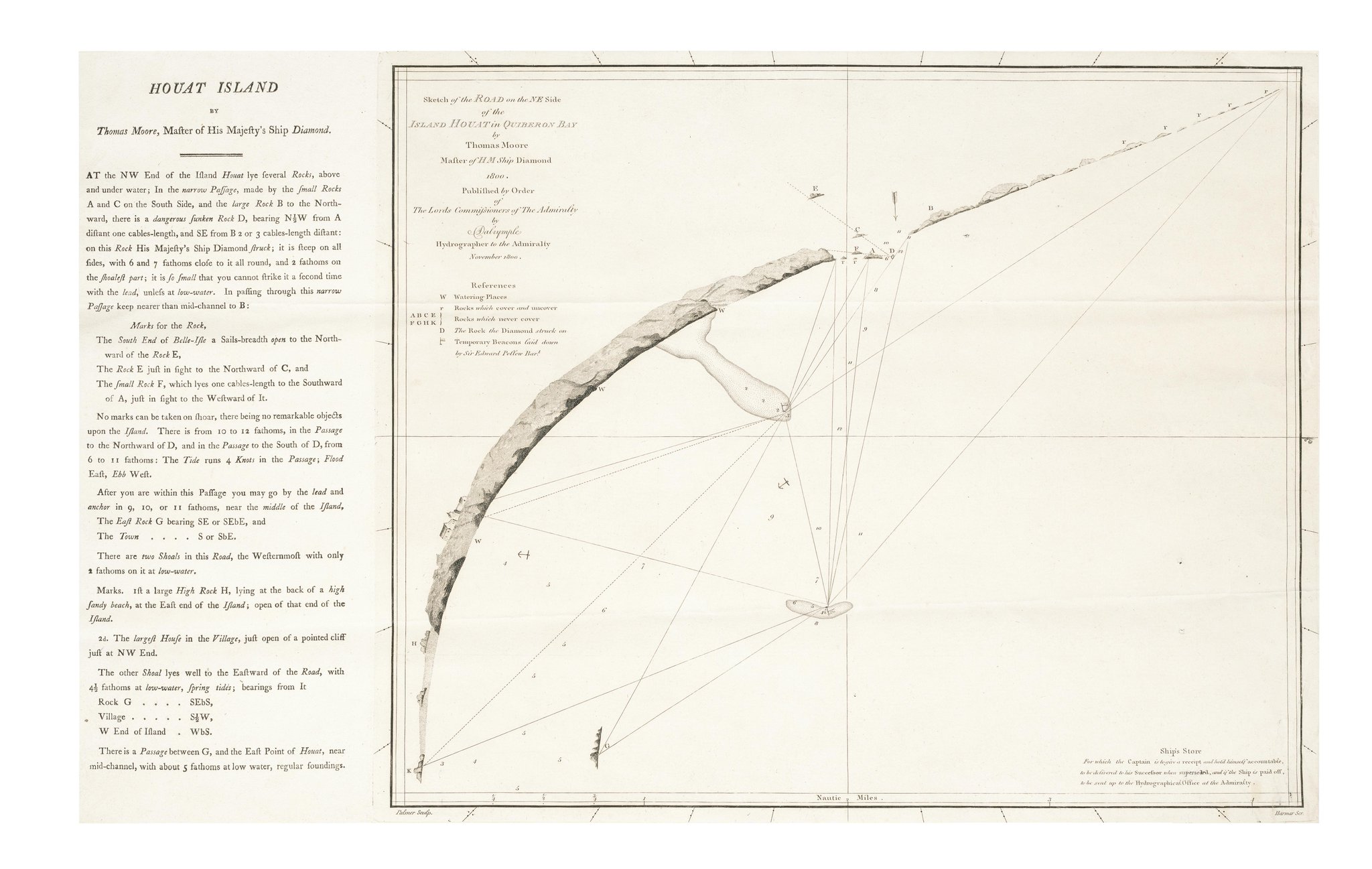
Sketch of the road on the NE side of the Island Houat in Quiberon Bay by Thomas Moore
(map oriented SW up)
(map oriented SW up)
Published Nov. 1800
 Houat island in the GeoGarage platform (SHOM chart)

Neptune françois the first nautical atlas published in France in 1693
7e carte particuliere des costes de Bretagne
 from Morbihan archives
 zoom from above
Carte de Belle-Isle et les Isles d'Houat et d'Hedic / Bellin -- 1764 -- BNF
see Rumsey collection : I /II

 The Coast of Bretagne from the Penmarks to port Douelan (1702-1707)
with zoom on Houat from Samuel Thornton
NY Public Library
extract from : Alexander Dalrymple (1737-1808), hydrographer to the East India Company and the Admiralty, as publisher: a catalogue of books and charts, by Andrew Stanley Cook (source : core.ac.uk)
Dalrymple 'was desired to look out for Engravers &c.' and a press was in place later in the same year.
The list of charts and plans 'fit to be engraved' has not survived, but it is generally accepted that the first plate printed at the Hydrographical Office was Moore's plan of the island Houat in Quiberon Bay, with a date of November 1800 (catalogue B904 001100 Houat)
The list of charts and plans 'fit to be engraved' has not survived, but it is generally accepted that the first plate printed at the Hydrographical Office was Moore's plan of the island Houat in Quiberon Bay, with a date of November 1800 (catalogue B904 001100 Houat)


Neptune françois the first nautical atlas published in France in 1693
7e carte particuliere des costes de Bretagne


Carte de Belle-Isle et les Isles d'Houat et d'Hedic / Bellin -- 1764 -- BNF
see Rumsey collection : I /II


with zoom on Houat from Samuel Thornton
NY Public Library
Links :
No comments:
Post a Comment