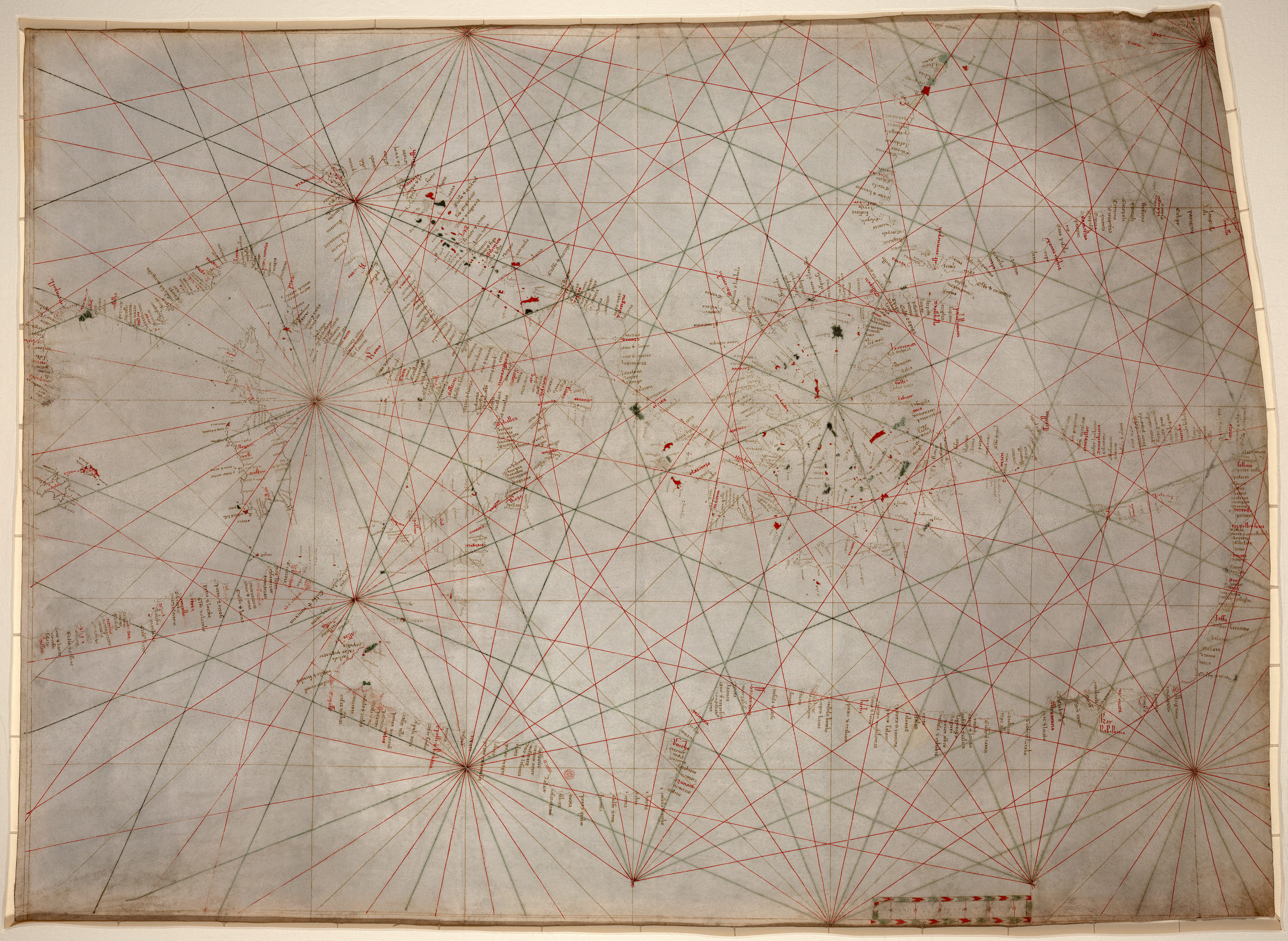
 Portolan nautical chart of Mediterranean Sea around 1320-1350.
This is oldest original cartographic artifact in the Library of Congress.
Map showing Mediterranean Sea from the Balearic Islands to the Levantine coast;
also covers western part of Black Sea. Author is anonymous, probably Genoan
Map showing Mediterranean Sea from the Balearic Islands to the Levantine coast;
also covers western part of Black Sea. Author is anonymous, probably Genoan
The Washington Post reports on a conference held last Friday at the Library of Congress: Re-Examining the Portolan Chart: History, Navigation and Science explored the mysterious origins of the portolan chart, which apparently appeared from nowhere, with no known antecedents, in the 13th century.
John Hessler, mathematical wizard and the senior cartographic librarian at the Library of Congress, slipped into the locked underground vaults of the library one morning earlier this week. Hessler, 49, is one of the world's leading experts in trying to decode the mysteries of the early world maps.
Slim, handsome, intense, bespectacled, Hessler approached a priceless 1559 portolan chart on the table before him, sketched in the hand of Mateo Prunes, the Majorcan mapmaker. The nautical map of the Mediterranean and Black seas is inked onto the skin of a single sheep.
It is a rare representative of one of the world's greatest and most enduring mysteries: where and how did medieval mapmakers, apparently armed with no more than a compass, an hourglass and sets of sailing directions, develop stunningly accurate maps of southern Europe, the Black Sea and North African coastlines, as if they were looking down from a satellite, when no one had been higher than a treetop?
The earliest known portolan (PORT-oh-lawn) chart, the Carta Pisana, just appears in about 1275 -- with no known predecessors. It is perhaps the first modern scientific map and contrasted sharply to the "mappamundi" of the era, the colorful maps with unrecognizable geography and fantastic creatures and legends. It bears no resemblance to the methods of the mathematician Ptolemy and does not use measurements of longitude and latitude.
And yet, despite it's stunning accuracy, the map "seems to have emerged full-blown from the seas it describes," one reference journal notes. No one today knows who made the first maps, or how they calculated distance so accurately, or even how all the information came to be compiled.
"The real mystery is that if you took all the notebooks from the sailors used in making these charts, along with the coordinates and descriptions," Hessler says, tapping the glass that covers the ancient vellum, "you still couldn't make this map."
Sponsored by the Philip Lee Phillips Society, the fundraising arm of the library's Geography and Map Division, it drew about 200 academics, donors and collectors to a day-long session that presented the ancient mystery of the portolans (from the Italian word for "ports"). It was one of those moments in which Washington, invariably portrayed as a dry city of faceless bureaucrats, revealed itself as a place filled with people who could, with a little fictional help, just as easily be the basis for a ripping good thriller.
"People think maybe the Romans made the first ones and they've been lost, or the Phoenicians, or even aliens," says Evelyn Edson, author of "The World Map: 1300-1492" and one of the conference's speakers. "It certainly seems related to the introduction of the compass, in the 11th century. But there's nothing at all to explain how they were made. . . . It's been very tempting for people over the years to try to make up the answer."
"The ancient Greeks and Romans had traditions of map-making, there's Ptolemy, and there's a line of progression," Hessler says. "But here, it just explodes out of nowhere. It appears to be a true invention of the Middle Ages."
Hessler's means of research isn't cultural or nautical -- it is entirely mathematical. He has taken 22 of the few hundred portolan maps known to be in existence and measured them against modern maps of the same area. He uses, say, 100 points of comparison on each map and then applies complicated algorithms to calculate the differences between each point on each map. (We could go into your basic Euclidean transformation method of calculating scales of error, and of course the Helmert transformation, but since these calculations take three or four months for each map, let's just move along.)
Hessler compares these two maps on a computer-modeled overlay, with the scale of error then plotted onto a "deformation grid." He is then able to see where the charts were more accurate and where they were less accurate, from which he infers where sailing and close observation took place, and which areas were more loosely charted. This, in turn, reveals more about the birthplace and methodology of the map. For example, the maps were good in the various seas of the Mediterranean, but terrible once out in the Atlantic, rounding up to the British Isles.
"That tells me different sources were used to make the same map," he says.
"So now you start to discover where those different charts came from, and how they got to the mapmaker."
The maps usage began to come to an end during trans-Atlantic exploration. For all their regional accuracy, the mapmakers did not know how to calculate for the curvature of the earth on a flat map. Across the Mediterranean, they could take you from port to port because the distances were comparably small. Over the distance of the Atlantic, if you set out for modern-day Miami, you'd wind up on Long Island.
Still, they were reliable guides to the known world for 400 years, and they have concealed the secrets of their origins and methods for another four centuries, leaving the answers to the realm of novelists and storytellers.
"Even with all the research that has been done on them the world over," Hessler says, looking up from the Prunes masterpiece, "there's not a single question about them that we can definitively answer."
Links :
- MapHist, discussion group on the history of cartography
- Rumsey historical collection on Google Maps
- From Portolan charts to virtual beacons : an historic overview of mediated communication at sea
- The history of early dead reckoning and celestial navigation
- Dead reckoning and magnetic declination : unveiling the mystery of Portolan charts
Robert Putman : The development of the sea charts till the second half of the 16th century
ReplyDeleteRobert Putman : Dutch sea charts from Hollands golden age