Nautical charts have all a horizontal datum.
On a global basis, the International Hydrographic Organization (IHO) designated the use of the World Geodetic System (WGS) as the universal datum.
Since then, the horizontal features have been based on WGS 84 or in other geodetic reference systems which are compatible, such as NAD 83 (in the US) or the ITRF combined with the GRS80 ellipsoid.
But what about heights ?
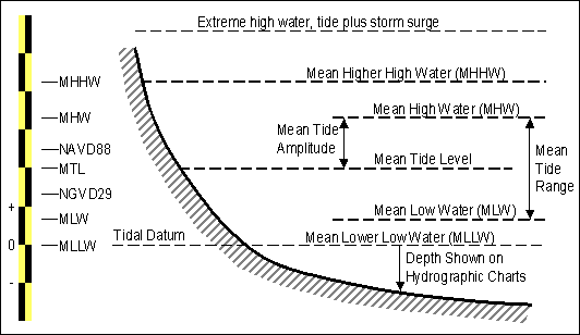
Nautical charts have depths referred to different tidal surfaces, which may vary from chart to chart. Tide heights are given relative to the "datum" which in most cases is one of different benchmarks corresponding to low tides of varying extremeness.
In the United States, Mean Lower Low Water (MLLW) is the typical low water reference surface (MLWS in Nederlands, LAT in Germany...)
By the way, to support harbor and river navigation, bridge clearances are also typically referenced to mean high water (MHW): not to a low water...
Vertical datum used by software covering the whole planet (such as Google Earth) is the WGS84 EGM96 Geoid which gives altitudes in meters above sea level (MSL) while seafloor mapping software (Hypack, Olex...) reference bathymetric survey data to Low Water vertical datums...
In a goal of uniformity, seamless VDatum software emerges to cover all of the U.S. coastal areas out to 25 nautical miles from land. The availability of VDatum nationwide will enable bathymetric, topographic and coastline data to be easily transformed and assembled in a manner that complements dissemination through national databases.
Last week the National Oceanic and Atmospheric Administration held a Federal Geospatial Summit in Maryland to discuss the proposed improvements to the National Spatial Reference System (NSRS) in the US.
The meeting discussed how the replacement of the North American Datum of 1983 (NAD83) and the North American Vertical Datum of 1988 (NAVD88) will positively impact measurement and operations.
The agency recently received the findings of an independent study that shows the benefits to the U.S. economy for better positioning.
The study found that the NSRS provides a benefit of more than $2.4 billion annually to the U.S. economy, and that an additional $522 million in economic benefits could be realized by improving the precision of elevation measurements, with an estimated $240 million saved by improved floodplain management.
The existing vertical datum means elevation errors from 16 inches to 6 feet at sea level.
The improved Gravity for the Redefinition of the American Vertical Datum (GRAV-D) reference system would improve that error to under an inch.
Links :
- overview of the 'U.S. economy for better positioning' study / full report
- NSRS / Elements of NSRS
- NOAA : Tutorial geodesy
- Height modernization program
- Water level information
Heights in Coordinate Systems
ReplyDelete