
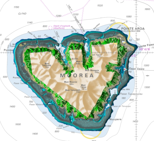
3D model from airborne topo/bathy Lidar.
(Image courtesy: Leica Geosystems)
(Image courtesy: Leica Geosystems)
The exploration and classification of the seabed have always been crucial for various scientific, environmental and commercial purposes.
Traditional methods of seabed classification have relied heavily on sonar and direct sampling techniques.
However, recent advancements have opened up new possibilities, particularly through the fusion of airborne imaging and bathymetric Lidar data.
This article delves into the potential of these fused datasets for large-area shallow seabed classification.
Bathymetric Lidar (light detection and ranging) technology offers the ability to create precise 3D maps of the seabed, providing valuable data on its morphology.
Additionally, the radiometric properties of both the water volume and the seabed are recorded in the Lidar wavelength (515nm).
The Lidar laser pulses are typically emitted with a constant pulse energy from a constant altitude, ensuring that the radiometric response does not vary with sun angles, cloud shadows and atmospheric losses as it does with passive imaging.
Furthermore, the shape of the received reflection can provide information on whether the emitted beam has been reflected off high vegetation or a flat seabed, for example.
All this information can be used to aid a seabed classification algorithm.
Airborne imaging
Modern bathymetric Lidar systems also integrate airborne imaging in four bands: red, green, blue and near infrared (NIR delivering a resolution of typically 5cm).
This passive imaging primarily aids in seabed classification, as different materials reflect different wavelengths.
Unlike imaging over land, water significantly impacts the measured radiometry, which must be compensated for.
The water surface can cause specular reflections from the sun (sunglint), affecting certain sections of the image.
Additionally, the transmission varies for different wavelengths: water is almost opaque for NIR, the red band provides information for only a few metres even in clear waters, and the blue and green bands have significantly higher transmission.
Creating useful radiometric seabed information from airborne imaging typically requires advanced image normalization algorithms, including solar radiation and sun angle modelling, sunglint removal and compensation for water radiometric properties.
The depth measured from Lidar plays a significant role in aiding these normalization algorithms.
 Airborne RGB image, co-collected with the bathy Lidar.
(Image courtesy: Leica Geosystems)
Airborne hyperspectral
Airborne hyperspectral imaging collects passive imaging with a lower spatial resolution but in many more and narrower bands than airborne imaging.
The additional bands offer more accurate modelling of water properties and seabed radiometry.
However, like airborne imaging, advanced algorithms are needed for data normalization for seabed classification use.
Fusing the datasets
The fusion of imaging and Lidar data combines the strengths of all technologies, resulting in a more comprehensive and accurate representation of the seabed.
By integrating passive imaging radiometric data with precise 3D bathymetric information, we can gain deeper insights into the seabed’s characteristics.
This fusion allows for the identification of subtle features that might be missed when using either technology alone.
Applications of fused data in seabed classification
Habitat mapping:
Fused imaging and Lidar data can be used to create detailed habitat maps, identifying different types of seabed environments and the species that inhabit them.
This information is crucial for marine conservation efforts and the management of marine protected areas.
This can include additional factors such as seabed slope and roughness derived from the bathymetric information and ‘health’ metrics such as chlorophyll presence and algal blooms from the hyperspectral data.
River exploration:
Bathymetric Lidar is heavily used for river mapping, primarily for the purpose of flood modelling and mitigation.
The radiometric information can however reveal important information, such as playgrounds for salmon habitats and the presence of run-off from adjacent land use.
Environmental monitoring:
The radiometric information can however reveal important information, such as playgrounds for salmon habitats and the presence of run-off from adjacent land use.
Environmental monitoring:
Fused data can be used to monitor changes in the seabed over time, as well as local pollution in the water, providing valuable information on the impacts of human activities such as trawling, dredging and sewage outlets and natural events such as storms and earthquakes.
Archaeological surveys:
Archaeological surveys:
Underwater archaeology can also benefit from the fusion of imaging and Lidar data.
Detailed maps of the seabed can reveal the locations of shipwrecks, submerged settlements and other archaeological sites, aiding in their preservation and study.
Detailed maps of the seabed can reveal the locations of shipwrecks, submerged settlements and other archaeological sites, aiding in their preservation and study.
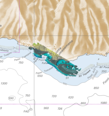
 Seabed classification based on fused airborne bathy Lidar and imaging data.
(Image courtesy: Leica Geosystems)
Comparison with other technologies
Sonar: Sonar technology is widely used, and significant advancements are taking place, particularly in utilizing sonar backscatter information for seabed classification.
Compared to airborne capture, sonar covers much smaller areas and its efficiency decreases with decreased depth, whereas airborne capture maintains constant efficiency.
Many bathymetric Lidar survey providers also capture shipborne sonar data and fuse the datasets to optimize collection efficiency.
It is important to note that sonar measures different properties compared to airborne data.
While sonar measures the ‘hardness’ of the seabed, airborne data collects ‘radiometric’ properties.
ROVs and direct underwater sampling: Equipping ROVs (remotely operated vehicles) and/or towed underwater devices with cameras and sonar technology allows for data capture very close to the seabed with remarkable resolution.
This high-resolution data enables detailed species recognition, classification and identification.
The primary disadvantage compared to airborne capture is the limited area coverage.
However, when used in combination with airborne capture, such datasets are ideal for creating training datasets for machine learning algorithms, enabling large-scale classification.
Satellite-based seabed classification: Satellite-captured multispectral data offers another method for seabed classification.
Unlike airborne data, satellite remote sensing is heavily affected by atmospheric conditions, where small errors in atmospheric correction can lead to significant errors in the measured radiometric properties of the seabed.
Additionally, cloud coverage can severely impact the capture of satellite images, making it challenging to find suitable images to be used, depending on the area of interest.
Compared to airborne imaging, satellite resolution is much lower, and compared to airborne Lidar, depth penetration and accuracy are significantly less.
However, combining airborne Lidar and satellite data can be an effective approach for scaling.
The potential of data fusion
Data fusion of multiple sensors offers large potential for enhanced seabed modelling.
These technologies provide different resolutions, measure multiple properties and cover different parts of the seabed.
By combining the strengths of multiple data sources, we can achieve a more complete, detailed and accurate understanding of the seabed’s characteristics.
This has far-reaching implications for habitat mapping, resource exploration, environmental monitoring and underwater archaeology.
As technology continues to advance, the possibilities for using fused data in seabed classification are bound to grow, paving the way for new discoveries and innovations in marine science.
Advancements in airborne topobathymetric Lidar and imaging
Airborne topobathymetric Lidar and imaging offer an unmatched combination of accuracy and resolution for nationwide coastal and inland water surveys in shallow waters.
Recent developments have increased collection efficiency by up to 250% compared to previous generations, enabling not only one-off collections but also repetitive surveys needed to monitor changes over time in a cost-efficient manner.
As about 40% of the world population lives in coastal zones, coastal nearshore information is highly valuable for maximizing the return on infrastructure investments, mitigating risks from coastal changes and preserving essential marine habitats.
More and more countries understand the value of an updated national coastal elevation model and the market for airborne bathymetric Lidar is therefore likely to continue to grow.
 Modern freshwater pipeline and remains from Bronze Age construction on the seabed.
The Bronze Age construction is estimated at 3,300–3,500 years old, located at about four metres depth due to land mass elevation change.
(Image courtesy: Leica Geosystems)
Links :
No comments:
Post a Comment