From Unidivers by Marjolaine Tanguy
A territory that maps bring back to life.
This is the promise kept by the exhibition L’île à la carte – Ouessant disparu, Ouessant imaginé (The island on the map – Ouessant lost, Ouessant imagined), on display until November 2, 2025, at the Stiff lighthouse.
Organized by the Ar(t) Stiff association and curated by cartographer Laurent Gontier, this geo-historical exploration brings to life a submerged past, between military memory, ghost landscapes, and engineers' utopias.
The magnificent catalog that accompanies it, published by Les Îliennes, is a scholarly and sensitive compendium of representations of Ouessant since the 17th century.
From the very first pages of the book, a strong intuition emerges: a map is never neutral.
It is the imprint of an era, a power, an intention.
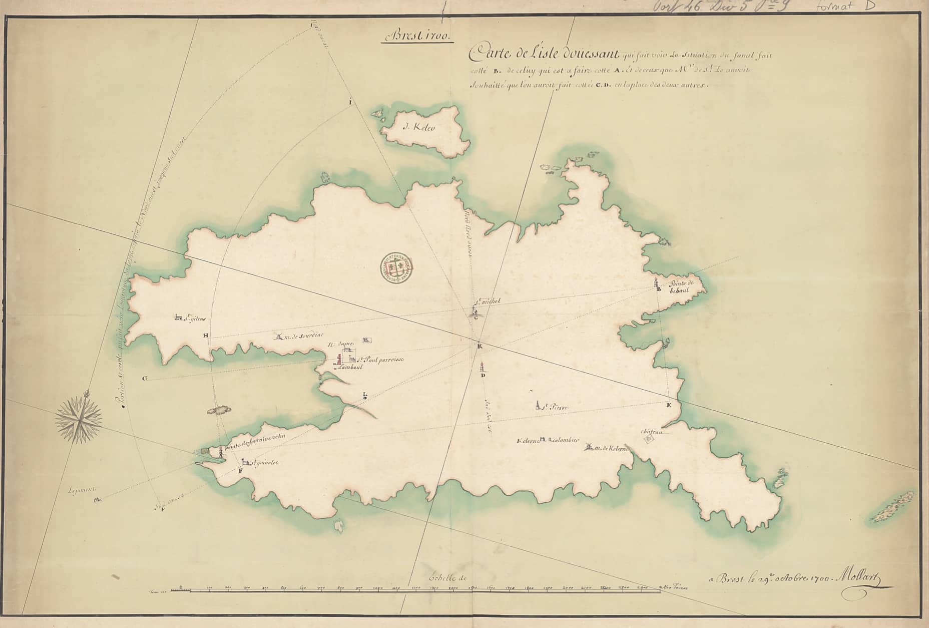
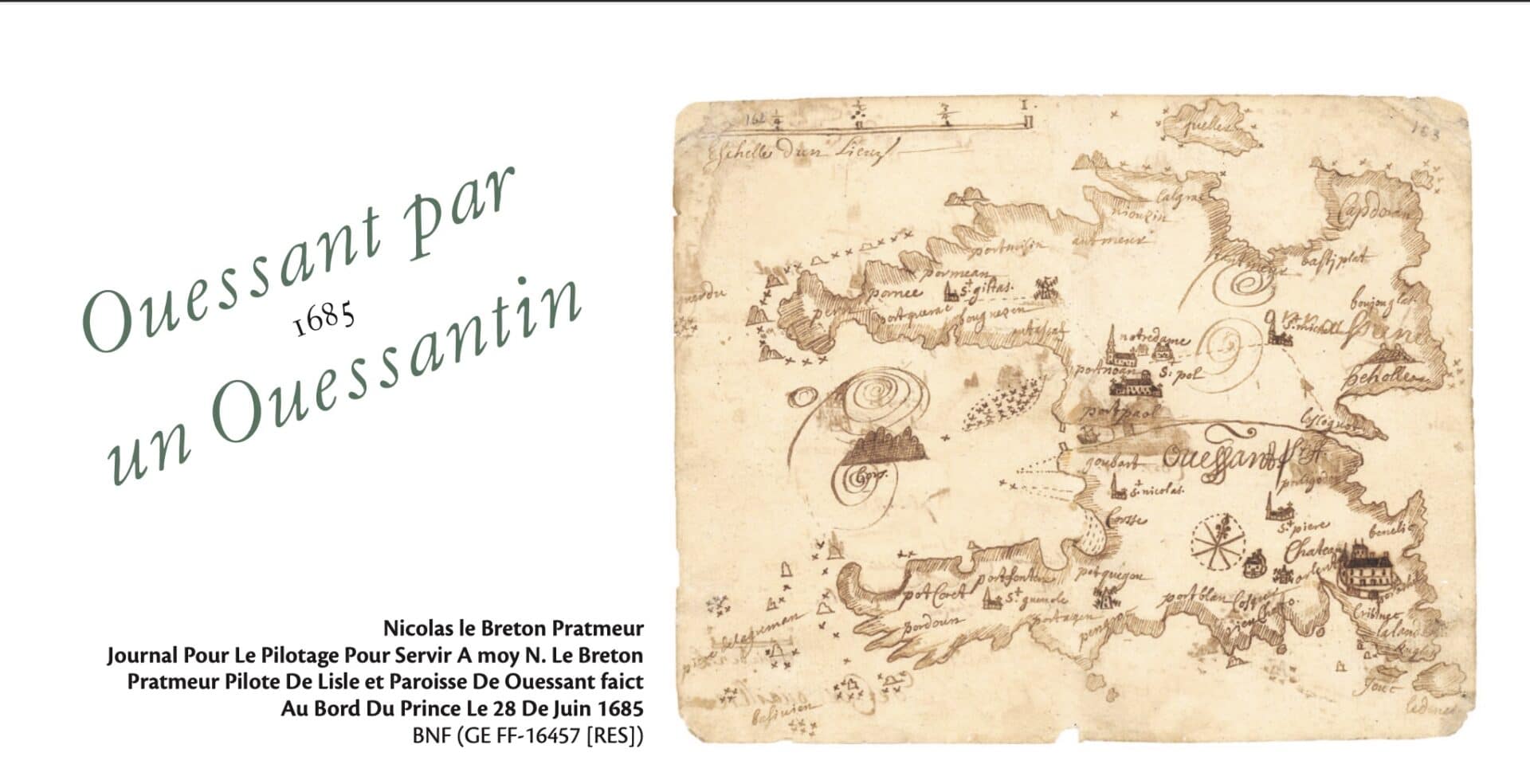
Through a rich selection of documents from the Defense Historical Service, the BnF, the SHOM, and departmental archives, the exhibition shows Ouessant as seen by military engineers, naval pilots, surveyors, and cadastral dreamers.
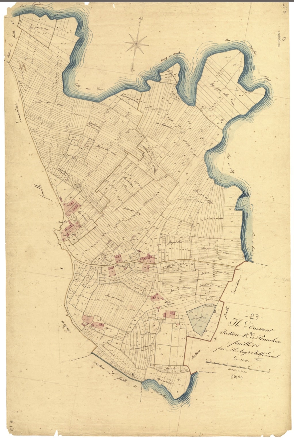
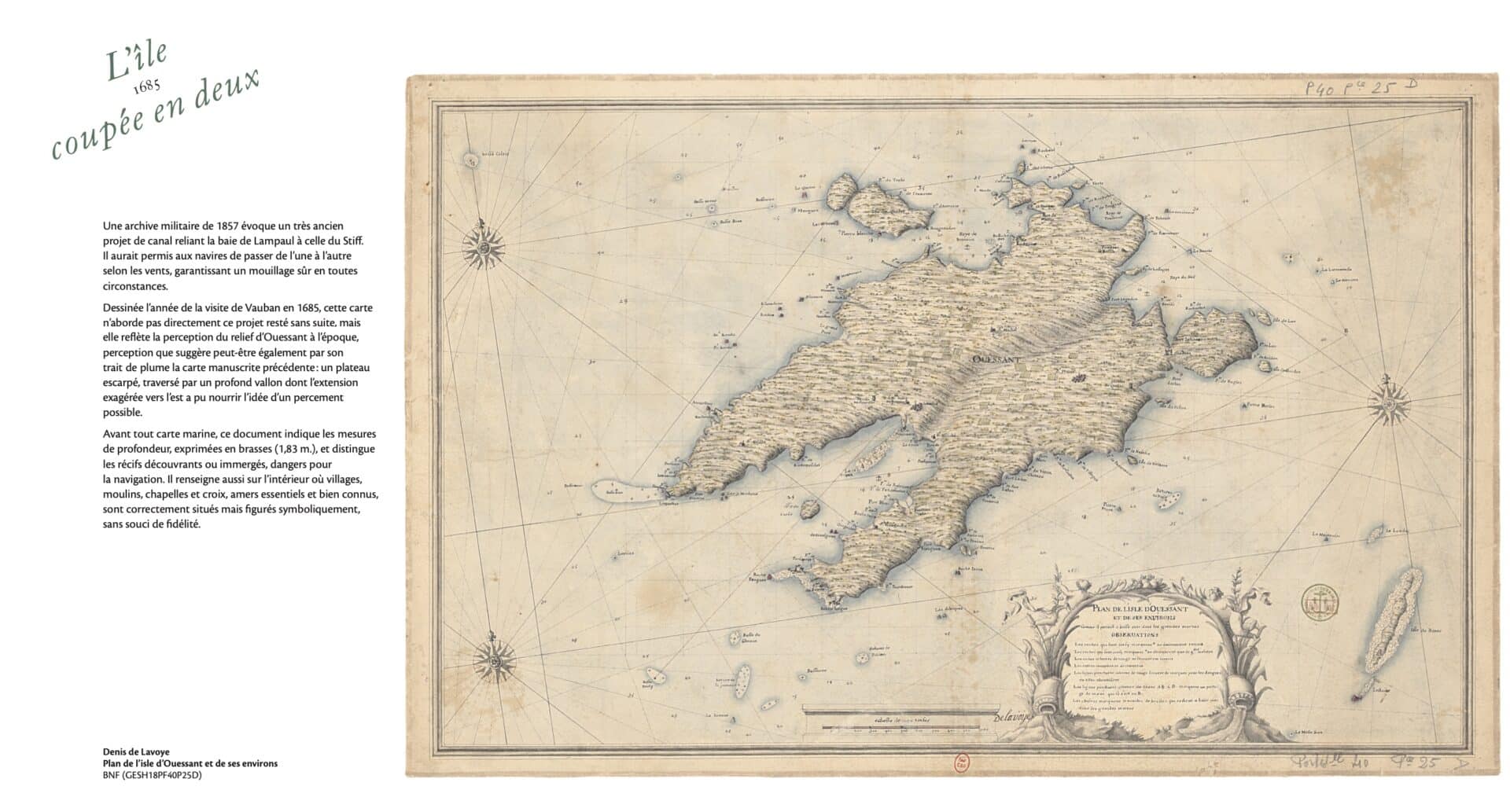
From Vauban's maps (1685) to the surveys of the Génie in the 19th century, another Ouessant emerges: a military island, strategic, defended, planned.
An island crisscrossed by coastal batteries, forts that were never built, abandoned dykes, and vanished chapels.
An island seen from above, but also traversed by the imagination.
This is the promise kept by the exhibition L’île à la carte – Ouessant disparu, Ouessant imaginé (The island on the map – Ouessant lost, Ouessant imagined), on display until November 2, 2025, at the Stiff lighthouse.
Organized by the Ar(t) Stiff association and curated by cartographer Laurent Gontier, this geo-historical exploration brings to life a submerged past, between military memory, ghost landscapes, and engineers' utopias.
The magnificent catalog that accompanies it, published by Les Îliennes, is a scholarly and sensitive compendium of representations of Ouessant since the 17th century.
From the very first pages of the book, a strong intuition emerges: a map is never neutral.
It is the imprint of an era, a power, an intention.
Through a rich selection of documents from the Defense Historical Service, the BnF, the SHOM, and departmental archives, the exhibition shows Ouessant as seen by military engineers, naval pilots, surveyors, and cadastral dreamers.
From Vauban's maps (1685) to the surveys of the Génie in the 19th century, another Ouessant emerges: a military island, strategic, defended, planned.
An island crisscrossed by coastal batteries, forts that were never built, abandoned dykes, and vanished chapels.
An island seen from above, but also traversed by the imagination.
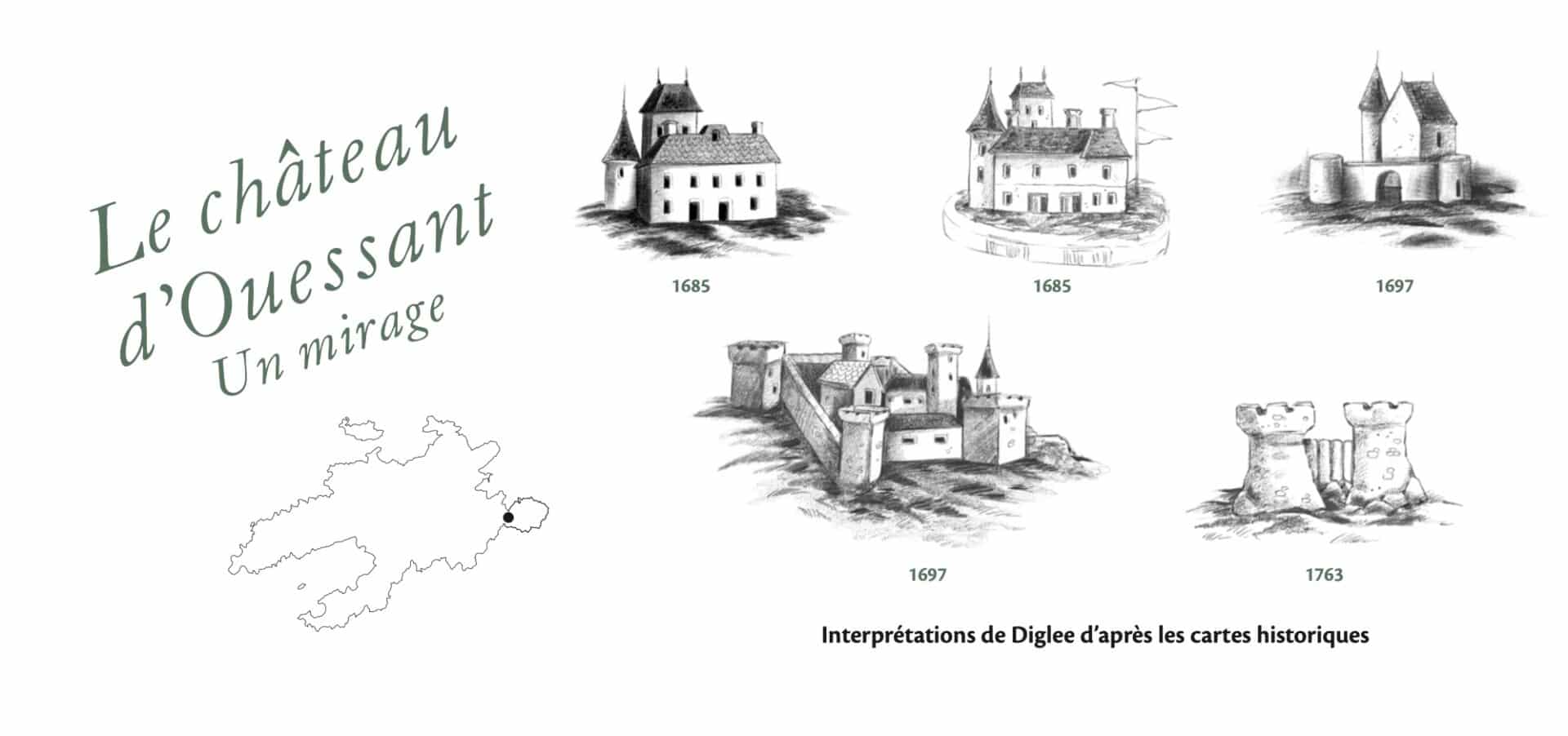
Laurent Gontier creates a dialogue between the maps to bring forth an alternative topography: that of forgotten intentions.
By revealing the successive layers of abandoned projects, he recreates a Ouessant that could have been.
This speculative reconstruction, both rigorous and poetic, culminates in 3D reconstructions of the Saint-Michel fort and the Créac'h lighthouse project.
The exhibition catalog is not just a simple annotated guide.
It is also the logbook of an investigation conducted over more than ten years by its author.
Gontier recounts his residencies on the island, his discoveries in the attics of the town hall, his dialogue with the inhabitants of Ouessant and schoolchildren, his comings and goings between the Napoleonic land registry and contemporary wastelands.
This interweaving of personal narrative, field research, and historical scholarship gives the project a rare depth.
It touches on geography as much as it does collective memory.
The island becomes a palimpsest, where traces of the past still surface in the landscape, in the names of plots of land, in a forgotten ruin.
At the heart of the project is an ethic of transmission: passing on to future generations what maps teach us—their graphic beauty, their technical rigor, their narrative power, but also their incompleteness—what they leave unsaid, what they leave to the reader's imagination.
The exhibition concludes with a contemporary section that questions what remains of these maps today: a collapsed wall in Kernoas, a cross on a vanished chapel, an incongruous relief at the bend in a path.
The map does not freeze space: it extends it.
It makes you want to walk, to search, to see differently.
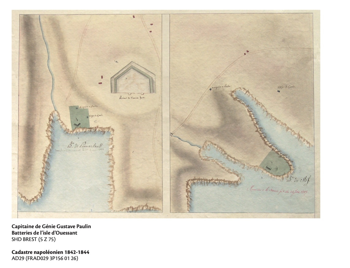
"The attentive and knowledgeable eye can still spot the rare traces of the old batteries across the island.
The most spectacular remains are located at Kernoas, at the entrance to the Penn Arland peninsula.
Beneath the grass, the embankments and ditches designed to protect the cannons retain clearly marked contours, forming a triangle whose sides cover the enemy's possible approaches.
Its shape, clearly visible on the Napoleonic cadastre, is intriguing.
In particular, the two arcs to the east, which some believe to be the base of the towers of the old castle of Ouessant.
Published in June 2025, the book-catalogue L’île à la carte – Ouessant disparu, Ouessant imaginé (ISBN 978-2-494215-04-7) is a work of art and knowledge.
Richly illustrated and featuring original cartography, it is a valuable tool for island history enthusiasts, researchers, teachers, and all lovers of Ouessant.
Richly illustrated and featuring original cartography, it is a valuable tool for island history enthusiasts, researchers, teachers, and all lovers of Ouessant.

Ouessant in the GeoGarage platform (SHOM nautical raster chart)
No comments:
Post a Comment