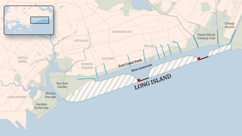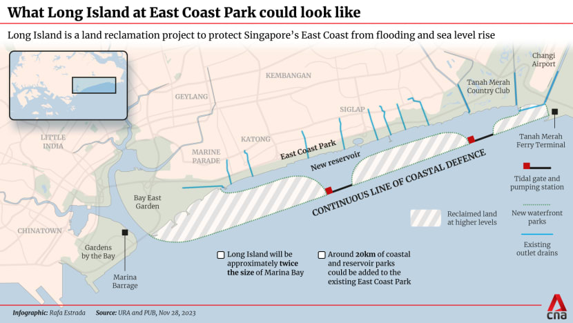
Long Island's 800ha of reclaimed land off East Coast could be split into
three segments catering to commercial and residential use; recreational
activities; and Changi's hub ambitions, according to an expert.
(Graphic: CNA/Rafa Estrada)
From CNA by Matthew Mahan
Experts say the "audacious" plan could meet the country's long-term needs up to 50 years down the line.
Singapore announced on Tuesday (Nov 28) potential plans for a project on its east coast which would reclaim around 800ha of land - the size of over 1,000 football fields.
Technical studies into this "Long Island" will start from 2024 and be carried out over the next few years.
What does it involve?
Twice the size of the downtown Marina Bay area, Long Island could take the form of tracts of land a distance away from the East Coast shoreline, but extending from Marina East to Tanah Merah.
This would create an enclosed waterbody - eventually, a freshwater reservoir - in front of East Coast Park.
Localization with the GeoGarage platform (MPA ENC chart)
Long Island would add around 20km of new coastal and reservoir parks.
It was first mooted under the 1991 Concept Plan, Singapore's second strategic land use and transportation plan.
Prime Minister Lee Hsien Loong mentioned Long Island during his National Day Rally in 2019, and it was showcased at an exhibition by the Urban Redevelopment Authority (URA) last year.
URA said it will seek public feedback and ideas on the plans, including potential names, as Long Island is currently a working title for the project.

Why is it needed?
Coastal protection measures are at the heart of the Long Island plan.
Studies have projected a rise in mean sea level of up to 1m by 2100. Combined with possible high tides and storm surges, sea levels could rise by 4m to 5m, threatening low-lying Singapore's shorelines.
Since 2021, Singapore has studied different parts of its coastline and in September it launched a research centre for coastal protection and flood management.
Around one-third of Singapore - including East Coast Park - is less than 5m above mean sea level. And the effects of high sea levels at the park - Singapore's largest, with a span of about 13km - are already being felt. In 2018 and in January this year, swathes of the park were flooded due to rain and high tide.
Solutions such as a 3m-high sea wall along the entire waterfront of East Coast Park are not ideal: This would limit access to the beach and sacrifice a substantial portion of the park.
The authorities thus settled on Long Island as a more optimal solution.
Hasn't Singapore reclaimed land before?
Yes. The country is no stranger to creating new land from the seas - in particular along its eastern coast.
For instance, the East Coast Reclamation Scheme was launched in 1966 and carried out over seven phases, at a total cost of S$613 million. It reclaimed a total of 1,525 ha of land.
Material for the reclamation came from hills in Bedok and Tampines, and sand was also sourced from overseas.
The reclaimed land was used largely for commercial and residential purposes, with Marine Parade the first housing estate to be built entirely on reclaimed land.
East Coast Park and East Coast Parkway were also born from this reclamation.
What could change?
Dr Woo Jun Jie, senior research fellow from the Institute of Policy Studies (IPS), said Long Island would kill two birds with one stone for Singapore's urban planners and policymakers, in terms of tackling rising sea levels and creating more space for recreation and waterfront living.
"The retention and creation of waterfront spaces around East Coast Park is particularly significant, given that waterfront land is very valuable and presents unique lifestyle and recreational opportunities," he told CNA.
Dr Woo said the impact would be more subdued when it comes to population planning, as the residential portion of Long Island would not be large and would only accommodate a relatively small amount of housing.
Property analysts have said that a mix of potentially up to 60,000 private and public properties would likely be built on the site.
Describing the plan as an "audacious" one, Dr Leong Chan-Hoong, head of policy development, evaluation and data Analytics at Verian, noted that successful implementation of Long Island may give insights on how other parts of Singapore could be redeveloped to protect against rising sea levels.
Professor Sing Tien Foo, provost's chair professor in the real estate department at the National University of Singapore's business school, told CNA the land supplied by Long Island could meet Singapore's long-term needs at least in the next 30 to 50 years.
Given that Marina Bay area reclamation works - spanning 360ha - took more than 20 years to complete and several years for the land to settle before the first commercial project was built, Long Island project can be expected to take even longer time, said Prof Sing.
He said Long Island could be divided into three segments.
The first, connecting to Marina East, would be a natural extension to the future Marina downtown Central Business District and will probably be planned for commercial and residential developments.
In the middle, parallel to East Coast Park, the land could be developed into premium water and recreational activities, said Prof Sing.
And the segment connecting to Changi Airport and Terminal 5 could extend the waterfront district and Changi Business Park, supporting Changi's transformation into a hub for logistics and aviation-related industries.
Links :
- CNA : Reclaimed 'Long Island' off East Coast would likely house a mix of public and private properties: Analysts / Singapore's 'Long Island' reclamation project: 5 other names that raised eyebrows
- SCMP : Singapore mulls building artificial ‘Long Island’ as ‘line of defence’ against rising sea levels
- MalayMail : Upcoming ‘Long Island’ will be about twice the size of Marina Bay, says Singapore’s National Development Minister

No comments:
Post a Comment