From BWorldonline y Amelia H. C. Ylagan
“Buy it, na!” Tony Carpio said to his friend Mel Velarde.
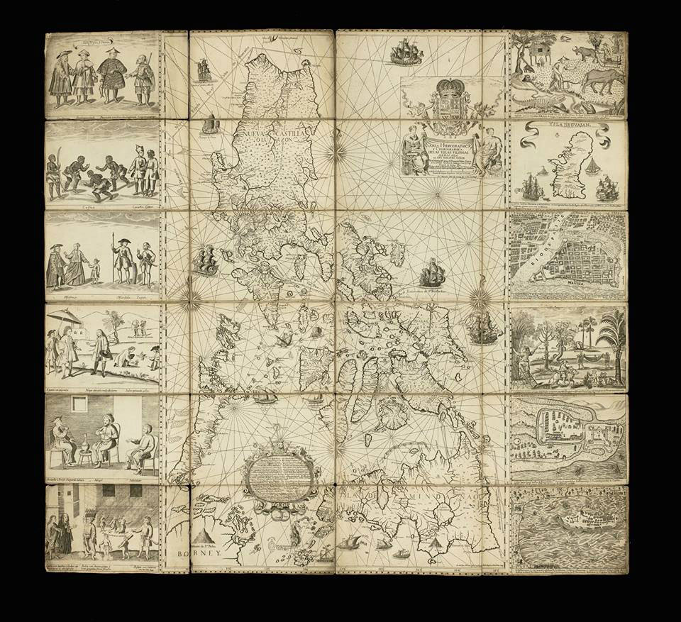
It was an old map that Tony encouraged Mel to buy — the Carta Hydrographica y Chorographica de las Islas Filipinas, more commonly known as the Murillo Velarde 1734 map — the oldest known map in Philippine history.
It was November 2014.
Sotheby’s had announced an auction of some 80 heirlooms of the Duke of Northumberland, Ralph George Algernon, which included the rare map.
Retired Supreme Court Associate Justice Antonio “Tony” Carpio, whose personal advocacy was (and still is) the protection and preservation of Philippine territorial and maritime sovereignty, specifically in the West Philippine Sea, immediately saw the value of the Murillo Velarde map to counter the adverse claims of China on Philippine territory.
“Local public and private museums declined to take part in the Sotheby’s bid.
The National Museum was interested but didn’t have the money, so the plan was for (Mel Velarde) to buy the map and sell it later to the National Museum,” Velarde recalled to media in June 2014.
The National Museum had a limit of only P5 million to buy rare items.
Mel Velarde paid £170,500 (approximately ₱12 million at that time) for the Murillo Velarde map — not for the name, he says, for he cannot trace his lineage to the Jesuit priest Father Pedro Murillo Velarde (1696-1753) who conceptualized and designed the map under orders from King Philip of Spain.
Filipinos Francisco Suárez and Nicolás de la Cruz Bagay did the artwork and engraving, respectively.
There are less than 50 extant copies of the map.
Some are mounted on a cloth backing measuring 112×120 cm.
The map itself measures 108×71 cm and is on a scale approximating 1:1,400,000.
The National Library of Congress of the USA, which owns one of the original copies, describes the “Carta” map thus:
“The Philippines were (sic.) at that time a vital part of the Spanish Empire, and the map shows the maritime routes from Manila to Spain and to New Spain (Mexico and other Spanish territory in the New World), with captions.
In the upper margin stands a great cartouche with the title of the map, crowned by the Spanish royal coat of arms flanked each side by an angel with a trumpet, from which an inscription unfurls.
The map is not only of great interest from the geographic point of view, but also as an ethnographic document.
It is flanked by 12 engravings, six on each side, eight of which depict different ethnic groups living in the archipelago and four of which are cartographic descriptions of particular cities or islands.
According to the labels, the engravings on the left show: Sangleyes (Chinese Filipinos) or Chinese; Kaffirs (a derogatory term for non-Muslims), a Camarin (from the Manila area), and a Lascar (from the Indian subcontinent, a British Raj term); mestizos, a Mardica (of Portuguese extraction), and a Japanese; and two local maps — one of Samboagan (a city on Mindanao), and the other of the port of Cavite.
On the right side are: various people in typical dress; three men seated, an Armenian, a Mughal, and a Malabar (from an Indian textile city); an urban scene with various peoples; a rural scene with representations of domestic and wild animals; a map of the island of Guajan (meaning Guam); and a map of Manila.
Scarborough Shoal and the Spratlys in Ancient Maps: An Exhibition, opened on Friday at the Alliance Française de Manille featuring the Murillo Velarde 1734 Map and Justice Carpio’s old Philippines map collection.
Justice Carpio, who was the guest of honor and main speaker at the Alliance Française, said “the 1734 Murillo Velarde map is a living document because it determines Philippine territory today, that is, Philippine territory cannot be determined without this map.”
This oldest Philippine map of “Las Yslas Filipinas” is the official Spanish Government map showing Philippine territory during the Spanish regime.
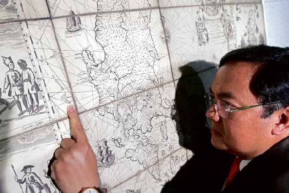
MEL VELARDE points to Bajo deMasinloc, now known as Panatag or Scarborough Shoal, as incontrovertible proof that it has always been part of the Philippines
– Photo by RICHARD A. REYES – www.plnmedia.com
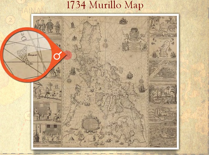
It shows Panacot (Scarborough Shoal) and Los Bajos de Paragua (the Spratlys) as part of Philippine territory, Justice Carpio said.
None of these islands drawn in this Murillo Velarde map appeared in China’s maps from centuries ago.
“The map debunks once and for all, the Chinese historical narrative that China has owned the South China Sea for 200 years.
Now the world knows better.
Thanks to the definitive ruling of the Arbitral Tribunal, China’s historical narrative has been exposed as fake news.
The map proves, beyond any shadow of doubt, that Spratlys and Scarborough Shoal were part of the Philippine territory as early as 1734,” Justice Carpio had said at a lecture at the Ateneo de Manila University in 2017.
At the Alliance Française opening, Justice Carpio explained that the aggressiveness of China in claiming the Spratlys and Scarborough Shoal started with the 1898 Treaty of Paris, after the Spanish-American war, when Spain ceded to the United States the archipelago known as the Philippine Islands in exchange for $20 million to ratify the Treaty.
Spain might have missed the Spratly Islands and Scarborough Shoal, putting these outside the western side of the polygonal lines of the Philippines in the Treaty of Paris.
But the United States noticed the exclusion, and demanded a revision of the map for the revised treaty, called the 1900 Treaty of Washington, which provided that “Spain relinquishes to the United all title and all claim of title, which she may have had at the time of the conclusion of the Treaty of Peace of Paris, to any and all islands belonging to the Philippine Archipelago, lying outside the lines described in Article III of that Treaty and particularly to the islands of Cagayan (Mapun), Sulu and Sibutu and their dependencies, and agrees that all such islands shall be comprehended in the cession of the Archipelago as fully as if they had been expressly included within those lines.”
The frame of reference for the 1900 Treaty of Washington’s definition of the Philippine territory was the Murillo Velarde map, which included the Spratlys and the Scarborough Shoal, But still, China’s position is that Philippine territory is limited to the islands enclosed by the polygonal lines drawn in the 1898 Treaty of Paris.
Justice Carpio said that China did not participate in the Arbitral proceedings, but “by officially submitting its Position Paper to the Arbitral Tribunal, China expressly and formally recognized that Philippine territory is defined by three treaties, including the 1900 Treaty of Washington… China is forever estopped from claiming that Philippine territory is limited to the islands enclosed by the Treaty of Paris.”

Scarborough Reef in the GeoGarage platform (NGA nautical raster chart)
It was only in 1947 that China started to claim the Spratlys, Justice Carpio said.
Scarborough Shoal appears in a 1948 Chinese map, named Si-ka-ba-luo, a Chinese transliteration of the English name Scarborough, The shoal was named by Captain Philip D’Auvergne, whose East India Company ship East Indiaman Scarborough grounded on one of the rocks on Sept.
12, 1784, before sailing on to China although it already had a Spanish name recorded in the 1734 Murillo Velarde map of Spanish Philippines (W. Gilbert [1804] A New Nautical Directory for the East-India and China Navigation .., pp.480-482).
The Carta Hydrographica y Chorographica de las Islas Filipinas, the Murillo Velarde 1734 map is indeed the “Mother of all Philippine Maps,” a “Living Document” to history, as Justice Carpio says.
Filipinos thank Justice Antonio Carpio for his unrelenting fight for Philippine territory and maritime sovereignty in the West Philippine Sea (South China Sea).
We thank Former Secretary of Foreign Affairs and Ambassador Albert del Rosario, who had fought together with Justice Carpio for Philippine rights on the seas.
Ambassador del Rosario, 83, passed away on April 18. May he rest in peace.
Links :
- Inquirer : The 1734 Murillo Velarde Map / ‘Mother of Philippine maps’ settles sea dispute with China
- PLN Media : Can historic map prove Scarborough Shoal belongs to the Philippines?
- GMA News : How 1734 Murillo Velarde map serves as living document of Philippine territory
- GeoGarage blog : Philippines uses 18th-century English aristocrat's map to ... / China revises mapping law to bolster claims over South ...
No comments:
Post a Comment