Map of satellite data shows how glacier ice thinning has spread deep into Antarctica
From ESA by
By combining 25 years of ESA satellite data, scientists have discovered that warming ocean waters have caused the ice to thin so rapidly that 24% of the glacier ice in West Antarctica is now affected.
A paper published in Geophysical Research Letters describes how the UK Centre for Polar Observation and Modelling (CPOM) used over 800 million measurements of Antarctic ice sheet height recorded by radar altimeter instruments on ESA’s ERS-1, ERS-2, Envisat and CryoSat satellite missions between 1992 and 2017.
The study also used simulations of snowfall over the same period produced by the RACMO regional climate model.
Together, these measurements allow changes in ice-sheet height to be separated into those caused by meteorological events, which affect snow, and those caused by longer-term changes in climate, which affect ice.
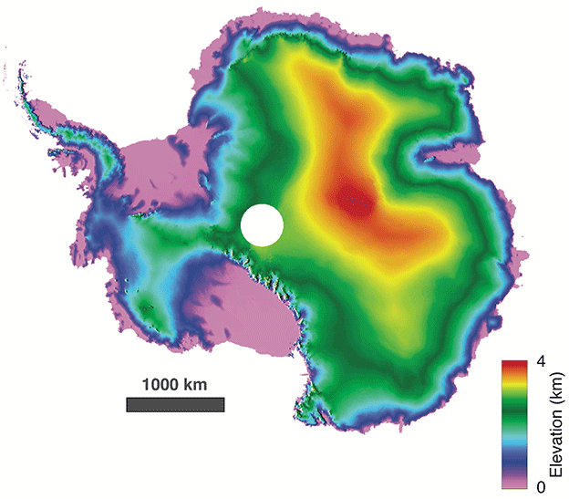
Europe's dedicated polar-monitoring Cryosat satellite
has produced its sharpest view yet of the shape of Antarctica.
(ESA:Cryotop/Edinburg Univ)
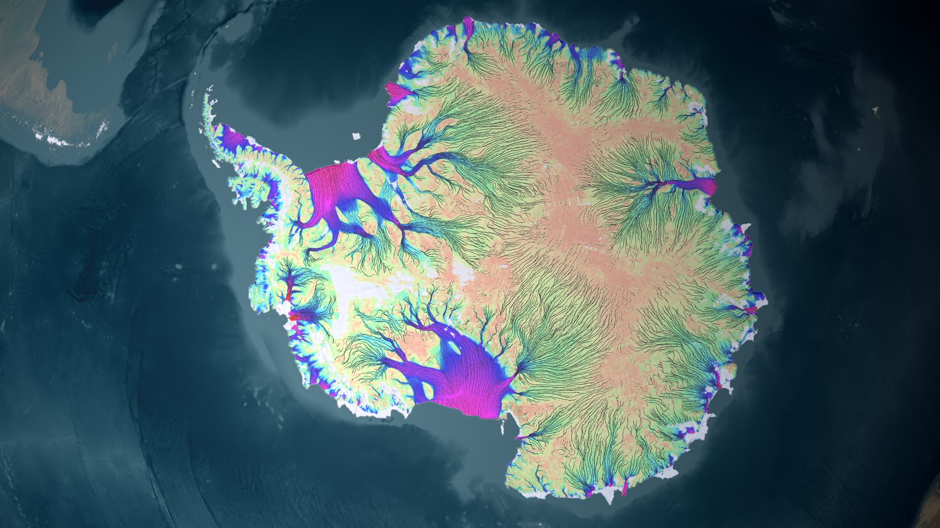
Velocity of recent ice flow around Antarctica. Thwaites Glacier is one of the smaller purple regions on the left side of this image.
New model finds processes that could help slow loss at some glaciers.
The ice sheet has thinned by up to 122 metres in places, with the most rapid changes occurring in West Antarctica where ocean melting has triggered glacier imbalance.
CPOM Director, Andy Shepherd, explained, “Parts of Antarctica have thinned by extraordinary amounts. So we set out to show how much was down to changes in climate and how much was instead due to weather.”
3D view of Thwaites Glacier’s grounding line migration over 500 years,
for old models (green) where the bedrock is rigid, and our new model
(red) where the bedrock is elastic.
Note that the ice shelf (floating
part of the glacier) has been masked to show the underlying bedrock.
Credit: Eric Larour @JPL/NASA/CalTech
Where the signal was greater they attributed its origin to glacier imbalance.
They found that fluctuations in snowfall tend to drive small changes in height over large areas for a few years at a time, whereas the most pronounced changes in ice thickness coincide with signals of glacier imbalance that have persisted for decades.
Prof. Shepherd added, “Knowing how much snow has fallen has really helped us to isolate the glacier imbalance within the satellite record.
We can see clearly now that a wave of thinning has spread rapidly across some of Antarctica’s most vulnerable glaciers, and their losses are driving up sea levels around the planet.

Twaites glacier with the GeoGarage platform (NGA nautical chart)
“After 25 years, the pattern of glacier thinning has spread across 24% of West Antarctica, and its largest ice streams – the Pine Island and Thwaites Glaciers – are now losing ice five times faster than they were in the 1990s.
“Altogether, ice losses from East and West Antarctica have added 4.6 mm of water to global sea level since 1992.”
ESA’s Marcus Engdahl, noted, “This is a fantastic demonstration of how satellite missions can help us to understand how our planet is changing.
The polar regions are hostile environments and are extremely difficult to access from the ground.
Because of this, the view from space is an essential tool for tracking the effects of climate change.”
Scientific results such as this are key to understanding how our planet works and how natural processes are being affected by climate change – and ice is a hot topic at ESA’s Living Planet Symposium, which is currently in full swing in Milan.
This study demonstrates that the changing climate is causing real changes in the far reaches of the Antarctic.
Links :
- PNAS : Ice sheet contributions to future sea-level rise from structured expert judgment
- BBC : Antarctic revealed in sharper 3D view / Antarctic instability 'is spreading' / Climate change: Global sea level rise could be bigger than expected
- The Guardian : ‘Extraordinary thinning’ of ice sheets revealed deep inside Antarctica
- Phys : 24% of west Antarctic ice is now unstable : study / 2-metre sea level rise 'plausible' by 2100: study / Antarctica's effect on sea level rise in coming centuries
- Gizmodo : Sea Level Rise Could Displace Nearly 200 Million This Century If We Don't Change Course
- PRI : This submarine’s historic tour under Thwaites Glacier will help scientists predict sea level rise
- Inverse : Melting Continental Glaciers Remain a World-Flooding Enigma
No comments:
Post a Comment