
NOAA satellite picture
From Washington Post by Jason
On Saturday, Hurricane Ophelia accomplished the unthinkable, attaining Category 3 strength farther east than any storm in recorded history.
Racing north into colder waters, the storm has since weakened to Category 1, but it is set to hammer Ireland and the northern United Kingdom with damaging winds and torrential rain on Monday as a former hurricane.

Wind wave height (until 13-14 meters forecasting) on Ventusky
see also CEFAS WaveNet interactive map
or Irish weather buoy network (IMOS) for live observations
see also CEFAS WaveNet interactive map
or Irish weather buoy network (IMOS) for live observations
The Irish Times reported that the storm could be the strongest to hit Ireland in 50 years.
The Daily Mail reported that the UK Met Office had compared the storm to Hurricane Katia, the tail end of which struck the region in 2011.

(National Hurricane Center)
The storm, about 700 miles south-southwest of Ireland’s southern tip and packing 90 mph winds, is jetting to the northeast at 38 mph.
As it heads north, it is forecast to weaken further and morph into what’s known as a post-tropical storm by Sunday night.
It is passing over progressively colder water, which is stripping the storm of its tropical characteristics.
However, even as these cold waters cause the eye of the hurricane and its inner core to collapse, its field of damaging winds will expand and cover more territory — even if it doesn’t pack quite the same punch near its center.

Percent likelihood of at least tropical storm-force winds over Ireland and the United Kingdom. (National Hurricane Center)
Maximum sustained winds of at least 70 mph are projected by the time Ophelia reaches Ireland, and the National Hurricane Center forecast shows almost the entirety of Ireland guaranteed to witness tropical-storm force winds of over 39 mph.
Hurricane force gusts of up to 80 mph are possible.
“This will be a significant weather event for Ireland with potentially high impacts — structural damage and flooding (particularly coastal) — and people are advised to take extreme care,” the Irish Meteorological Service said.
It issued a “red warning,” its highest-level storm alert for the southern and coastal areas.

GFS model projects wind gusts near 80 mph over southwest Ireland early Monday. (WeatherBell.com)
The UK Met Office issued an “amber wind warning” for northern Ireland, the second-highest alert, where it is predicting wind gusts up to 70-80 mph, and released the following statement:
A spell of very windy weather is expected on Monday in association with ex-Ophelia. Longer journey times and cancellations are likely, as road, rail, air and ferry services may be affected as well as some bridge closures.
There is a good chance that power cuts may occur, with the potential to affect other services, such as mobile phone coverage.
Flying debris is likely, such as tiles blown from roofs, as well as large waves around coastal districts with beach material being thrown onto coastal roads, sea fronts and properties.
This leads to the potential for injuries and danger to life.
Parts of southern and central Scotland and northern England also may face a hazardous combination of tropical storm-force winds and heavy rain.
Because the storm is moving so fast, its powerful blow will be brief, the worst lasting six to 12 hours in most locations.
It will leave the British Isles by Tuesday morning.
On Sunday, ahead of the storm, strong southerly winds were drawing abnormally warm conditions into the British Isles, with high temperatures up to 77 degrees (25 Celsius) forecast.
The Daily Mail reported that “swarms of deadly jellyfish” (actually, Portuguese man o’ war) had washed ashore on southern beaches.
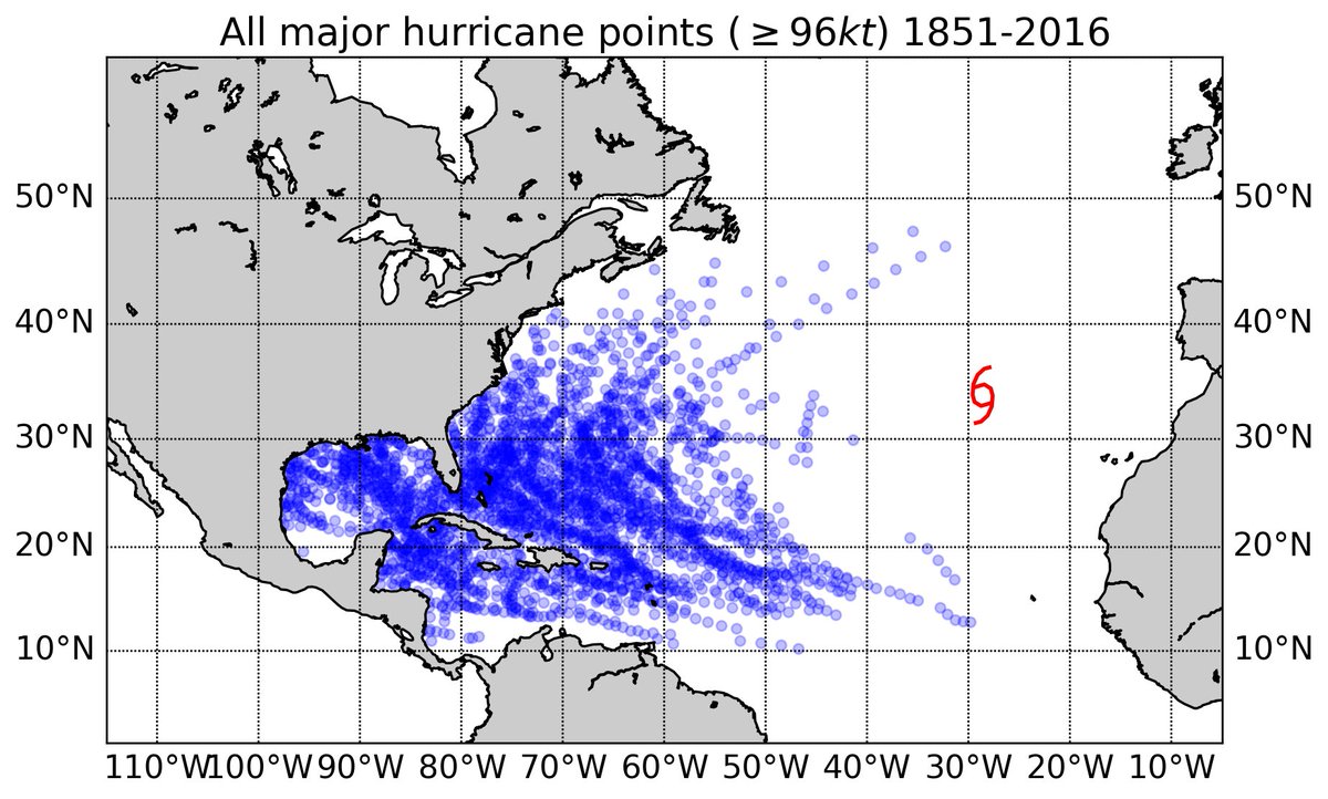
Ophelia’s place in history

Ophelia near peak intensity Saturday. (NOAA)
When Ophelia became a major — Category 3 (or higher) — hurricane Saturday, it marked the sixth such storm to form in the Atlantic this year, tied with 1933, 1961, 1964 and 2004 for the most through Oct. 14, according to Phil Klotzbach, tropical weather researcher at Colorado State University.

A singular trajectory
The storm is most remarkable, however, for where it reached such strength — becoming the first storm to reach Category 3 strength so far east.
— Sam Lillo (@splillo) October 14, 2017This figure really says it all. #Ophelia is a huge outlier from the typical envelope of major hurricane tracks in the Atlantic

Sea surface temperature difference from normal over Atlantic waters which Ophelia traversed. (NOAA)
While having a major hurricane so far east in the Atlantic Ocean is rare, it is not particularly unusual for former tropical weather systems to slam into Ireland and the United Kingdom.
As we wrote Friday, this happens about once every several years, on average, conservatively.
Links :
- WashingtonPost : Ophelia may slam Ireland, Britain as an ex-hurricane, but this isn’t as rare as you might think
- NYTimes : Ireland and Britain Brace for Unusual European Hurricane / 10 Hurricanes in 10 Weeks: With Ophelia, a 124-Year-Old Record is Matched
- CNN : Hurricane Ophelia heading to Ireland, then Scotland
- Mashable : 'Red' alert in Ireland as ex-hurricane Ophelia roars ashore with destructive winds
- Weather Underground : Ophelia Hits Category 3; Destructive Winds On Tap for Ireland
- Irish Times : Why is Hurricane Ophelia so powerful and why is it heading for Ireland?
Earther : Why a Bizarre Ex-Hurricane Is Pounding Ireland
ReplyDeleteArs Technica : Ophelia became a major hurricane where no storm had before
ReplyDeleteECMWF picture : Sometimes winds can be just as strong when a hurricane re-intensifies as an extratropical storm. With Ophelia land areas missed the worst.
ReplyDelete