Google and its partners are committed to using technology
to better understand and protect the ocean.

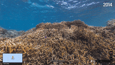
Mapping the ocean is key to preserving it.
Each image in Google Maps is a GPS-located digital record of these underwater and coastal environments, which can be used as a baseline to monitor change over time.
This comprehensive record of coral reefs showcases the beauty of these ecosystems and highlights the threats they face, such as the impact of increasing storms in the Great Barrier Reef and of rising water temperatures, factors causing the reefs to bleach white.
With just one click, you can swim underwater alongside some of the most wondrous and exotic creatures, including great white sharks in Australia.
 Mola mola, the world’s heaviest bony fish, in Crystal Bay, Bali
From Google_LatLon by Jenifer Austin and Brian Sullivan, Google Ocean Program
Covering more than 70 percent of the Earth’s surface, the ocean remains one of the most uncharted and undiscovered ecosystems on the planet.
Covering more than 70 percent of the Earth’s surface, the ocean remains one of the most uncharted and undiscovered ecosystems on the planet.
Home to the majority of life on Earth, the ocean acts as its life support system, controlling everything from our weather and rainfall to the oxygen we breathe.
Yet despite the ocean’s vital importance, the ocean is changing at a rapid rate due to climate change, pollution, and overfishing, making it one of the most serious environmental issues we face today.
Yet despite the ocean’s vital importance, the ocean is changing at a rapid rate due to climate change, pollution, and overfishing, making it one of the most serious environmental issues we face today.
Walk the coastline of Larsen Bay, Samoa, home to some of the most pristine coral reefs in the Pacific
Mapping the ocean is key to preserving it.
Each image in Google Maps is a GPS-located digital record of these underwater and coastal environments, which can be used as a baseline to monitor change over time.
This comprehensive record of coral reefs showcases the beauty of these ecosystems and highlights the threats they face, such as the impact of increasing storms in the Great Barrier Reef and of rising water temperatures, factors causing the reefs to bleach white.
These two images taken just one year apart, demonstrate reef deterioration from ocean warming.
With just one click, you can swim underwater alongside some of the most wondrous and exotic creatures, including great white sharks in Australia.
Google recommends you check out these amazing “street views” of ocean life:
- Dive with giant ocean sunfish (Mola mola) and giant parrotfish off the coast of Bali.
- Swim underwater alongside schools of giant travely in Mexico.
- Do the backstroke with humpback whales in the Cook Islands.
- See the breathtaking beauty of sea turtles in Timor-Leste.
- Search the ruins of shipwrecks in Aruba.
- In American Samoa, you can go for sunset walk along Ofu Airport Beach, or walk along Ofu beach, known as one of the most scenic beaches in the world.
- In Chagos Islands, you can tour Ile du Sel, a tiny island vegetated with a thick forest of coconut palms, and explore the famed bird nesting habitat of Grande Ile Bois Mangue.

Working closely with XL Catlin Seaview Survey, we’re announcing a select group of new partnerships for our underwater Street View program to map and publish more imagery of our ocean and water systems for the world to understand and explore.
- NOAA’s Office of National Marine Sanctuaries: Expanding our current partnership to bring unprecedented access to American marine protected areas
- Reef Check: Engaging and training volunteer citizen scientists to participate in ocean mapping and data collection
- Blue Ventures: Developing locally-managed marine areas for biodiversity and the benefit of coastal people throughout Madagascar and the Indian Ocean
- Our World Underwater Scholarship Society: Providing a program of firsthand underwater-related experiences to selected scholars across the world
- GUE’s Project Baseline: Empowering a global network of highly skilled SCUBA divers to create a lasting visual legacy of underwater conditions in oceans, lakes, rivers, springs, and caves all over the world
With so much of what happens on the ocean going unnoticed, Global Fishing Watch will aim to empower governments, the seafood industry, research institutions and the public with new tools to better inform sustainable practices and management policies.
This World Oceans Day, we hope that you’re inspired to learn more about ocean change.
So dive into the deeps of the sea and become engaged to protect the ocean and understand how it supports us, so that all of us can better support it in return.
Links :
- GeoGarage blog : Google SeaView : Ocean survey launches on Great Barrier Reef / Dive into the Great Barrier Reef with the first underwater imagery in Google Maps / Caribbean has lost 80% of its coral reef cover in recent years / Take a virtual swim with the dolphins on protected Brazilian islands
- Google LatLon : Dive in to the heart of the Coral Triangle in Asia, home of the richest coral reefs on Earth
No comments:
Post a Comment