Past sea level rise is not captured by models yet, in particular the response from ice sheets in Antarctica due to global warming.
Projections therefore can often be regarded to potentially underestimate future sea level rise.
For example, Overpeck et al. (2006), and Hansen (2007) suggest possibilities which could eventually lead to a nonlinear response from ice sheets - accelerating the current observed sea level rise.
On a warming Earth, seas inevitably rise, as ice on land melts and makes its way to the ocean.
And not only that — the ocean itself swells, because warm water expands.
We already know this is happening — according to NASA, seas are currently rising at a rate of 3.5 millimeters per year, which converts to about 1.4 inches per decade.
However, scientists have long expected that the story should be even worse than this.
Predictions suggest that seas should not only rise, but that the rise should accelerate, meaning that the annual rate of rise should itself increase over time.
That’s because the great ice sheets, Greenland and Antarctica, should lose more and more mass, and the heat in the ocean should also increase.

The altimeter record with decadal rates of change indicated.
Estimates during the early stages of the record (dashed)
are particularly subject to instrument related uncertainty
The problem, or even mystery, is that scientists haven’t seen an unambiguous acceleration of sea level rise in a data record that’s considered the best for observing the problem — the one that began with the TOPEX/Poseidon satellite, which launched in late 1992 and carried an instrument, called a radar altimeter, that gives a very precise measurement of sea level around the globe.
(It has since been succeeded by other satellites providing similar measurements.)
This record actually shows a decrease in the rate of sea level rise from the first decade measured by satellites (1993 to 2002) to the second one (2003 to 2012).
“We’ve been looking at the altimeter records and scratching our heads, and saying, ‘why aren’t we seeing an acceleration in the satellite record?’ We should be,” said John Fasullo, a climate scientist at the National Center for Atmospheric Research in Boulder, Colorado.
In a new study in the open-access journal Scientific Reports, however, Fasullo and two colleagues say they have now resolved this problem.
It turns out, they say, that sea level rise was artificially masked in the satellite record by the fact that one year before the satellite launched, the Earth experienced a major cooling pulse.
The cause?
The 1991 eruption of Mount Pinatubo in the Philippines, which filled the planet’s stratosphere with aerosols that reflected sunlight away from the Earth and actually led to a slight sea level fall in ensuing years as the ocean temporarily cooled.
“What we’ve shown is that sea level acceleration is real, and it continues to be going on, it’s ongoing, and we understand why you don’t see it in the short satellite record,” said Fasullo, who conducted the research along with scientists from the University of Colorado in Boulder and Old Dominion University.
The study was performed using a suite of 40 climate change models to determine how the Pinatubo eruption affected seas and the global distribution of water.
The scientists estimate as a result that sea level not only fell between 5 and 7 millimeters due to a major ocean cooling event in the eruption’s wake, but then experienced a rebound, or bounce back, of the same magnitude once the influence of the eruption had passed.

courtesy of Climate Central
So the researchers conclude that while no official acceleration trend can be seen in the satellite record now, that’s an artificial consequence of Pinatubo and should be gone over time — barring another Pinatubo-like event.
“Our initial impression of sea level rise was not only influenced by climate change and the rate of change, but the response and the recovery from the eruption itself,” says Fasullo.
“Those effects largely have ebbed by now, and once we get a few more years into the altimeter record, we should see a clear acceleration.
That’s really the punch line of the article.”
In fact, the researchers also removed the sea level effect of Pinatubo, and found that when they did so they could see sea level rise acceleration happening already.
Altimetric satellites are able to measure sea level and can observe how it has been changing with climate change since 1992.
Not only can they tell us the global change but also the regional changes. Sea level changes are due to thermal expansion of water, melting of the polar ice caps and continental glaciers and water inputs from land.
Tide gauges are able to tell us that sea level rose at a slower rate before the 1990s and then the global sea level trend increased after that.
This is likely due to the increase of greenhouse gasses and climate change.
The continued observation of sea level by altimetric satellites will be able to inform us what the future of sea level is.
credit : CNES (Centre National d'Etudes Spatiales) and Mira Productions
credit : CNES (Centre National d'Etudes Spatiales) and Mira Productions
One sea level rise expert who was not involved in the new study, Robert Kopp of Rutgers University, praised the work in response to a query from the Post.
The study, Kopp explained by email, found that the Pinatubo eruption would have caused seas to fall “just before the start of the altimetry record, the recovery from which was spread out of the remainder of the 1990s and therefore masked some of the acceleration that would otherwise have been seen in the tide-gauge record between the 1990s and the 2000s.
This makes strong physical sense.”
It also aligns better with actual observations from Greenland and Antarctica.
Scientists have shown that both of the Earth’s major ice sheets have seen an accelerating rate of ice loss in recent years, which ought to help drive an accelerating rate of sea level as well.

A record of Greenland mass loss based on satellite data from 2002 to the
present day. Data are in gigatons, or GT, equivalent to 1 billion
metric tons. (NASA)
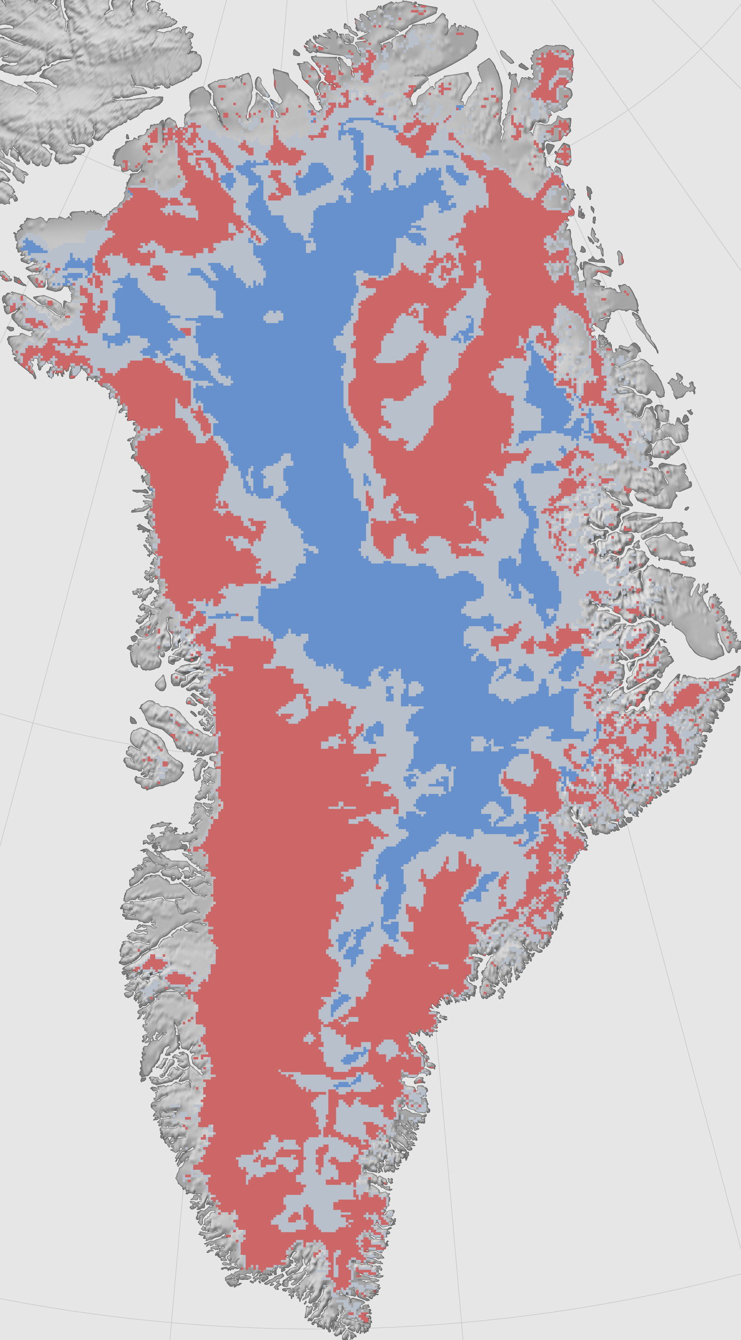
Greenland looks like a big pile of snow seen from space using a regular camera.
But satellite radar interferometry helps us detect the motion of ice beneath the snow.
Ice
starts flowing from the flanks of topographic divides in the interior
of the island, and increases in speed toward the coastline where it is
channelized along a set of narrow, powerful outlet glaciers.
In the east, these glaciers make their sinuous way through complex terrain at low speed.
They form long floating extensions that deform slowly in the cold north.
As
we move toward sectors of higher snowfall in the northwest and centre
west, ice flow speeds increase by nearly a factor 10, with many, smaller
glaciers flowing straight down to the coastline at several kilometers
per year.
This
complete description of ice motion was only made possible from the
coordinated effort of four space agencies: the Japanese Space Agency,
the Canadian Space Agency, the European Space Agency, and NASA's Jet
Propulsion Laboratory.
The
data will help scientists improve their understanding of the dynamics
of ice in Greenland and in projecting how the Greenland Ice Sheet will
respond to climate change in the decades and centuries to come.
This animation shows how ice is naturally transported from interior topographic divides to the coast via glaciers.
This animation shows how ice is naturally transported from interior topographic divides to the coast via glaciers.
The colors represent the speed of ice flow, with areas in red and purple flowing the fastest at rates of kilometers per year.
The vectors indicate the direction of flow.
In one thought experiment recently, former NASA climate scientist James Hansen calculated the consequences if the “doubling time” for ice loss is as fast as 10 years — finding dramatic sea level increases as a result.
“Doubling times of 10, 20 or 40 years yield sea level rise of several meters in 50, 100 or 200 years,” Hansen’s study concluded.
However, it is far from clear at this point that ice loss is actually increasing this rapidly.
GRACE satellites show as ice melts, Earth's gravitational and rotational fields change.
An animation showing “sea level fingerprints,” or patterns of rising and falling sea levels across the globe in response to changes in Earth’s gravitational and rotational fields.
Major changes in water mass can cause localized bumps and dips in gravity, sometimes with counterintuitive effects.
Melting glaciers, for example, actually cause nearby sea level to drop; as they lose mass, their gravitational pull slackens, and sea water migrates away. In this animation, computed from data gathered by the twin GRACE satellites between April 2002 and March 2015, sea level is dropping around rapidly melting Greenland (orange, yellow).
But near coastlines at a sufficient distance, the added water causes sea levels to rise (blue).
The computational method is described in Adhikari et al. (2016, Geoscientific Model Development). And, these solutions are presented in Adhikari and Ivins (2016, Science Advances).
So far, the U.N.’s Intergovernmental Panel on Climate Change officially estimates that the high-end sea-level rise projection for 2100 is lower than some of these scenarios, closer to about 1 meter (3.3 feet) by that year.
But that has recently been challenged by new work estimating that Antarctica alone could add this much to global sea levels by 2100 if high levels of human greenhouse gas emissions continue.
Fasullo says that debate — over precisely how fast acceleration happens, or where that leaves us in 2100 — remains unresolved.
For now, he says, at least it’s pretty clear that the acceleration is actually happening as expected.
“Accelerated sea level rise is real, and it’s ongoing, and it’s not something we should doubt based on the altimeter record,” said Fasullo.
Links :
No comments:
Post a Comment